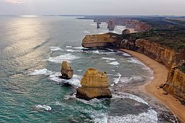
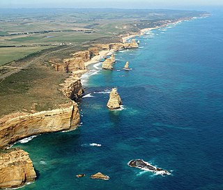
The Great Ocean Road is an Australian National Heritage-listed 240-kilometre (150 mi) stretch of road along the south-eastern coast of Australia, between the Victorian towns of Torquay and Allansford. Built by returned soldiers between 1919 and 1932, and dedicated to soldiers killed during World War I, the road is the world's largest war memorial. Winding through varying terrain along the coast, and providing access to several prominent landmarks, including the Twelve Apostles limestone stack formations, the road is an important tourist attraction.
The Port Campbell National Park is a national park in the south-western district of Victoria, Australia. The 1,750-hectare (4,300-acre) national park is situated approximately 190 kilometres (120 mi) south-west of Melbourne and approximately 10 kilometres (6.2 mi) east of Warrnambool. The park is located adjacent to the Great Otway National Park and the Bay of Islands Coastal Park.

London Bridge is an offshore natural arch in the Port Campbell National Park, Australia. The arch is a significant tourist attraction along the Great Ocean Road near Port Campbell in Victoria. This stack was formed by a gradual process of erosion, and until 1990 formed a complete double-span natural bridge.

The Shire of Moyne is a local government area in the Barwon South West region of Victoria, Australia, located in the south-western part of the state. It covers an area of 5,481 square kilometres (2,116 sq mi) and in June 2018 had a population of 16,887. It includes the towns of Port Fairy, Koroit, Mortlake, Macarthur, Peterborough, Caramut, Ellerslie, Framlingham, Garvoc, Hawkesdale, Kirkstall, Panmure, Mailors Flat, Purnim, Wangoom and Woolsthorpe. It also entirely surrounds the City of Warrnambool, a separate local government area. It was formed in 1994 from the amalgamation of the Shire of Belfast, Shire of Minhamite, Borough of Port Fairy, and parts of the Shire of Mortlake, Shire of Warrnambool, Shire of Dundas, Shire of Mount Rouse and Shire of Hampden.

Stawell ( "stall"), is an Australian town in the Wimmera region of Victoria 237 kilometres (147 mi) west-north-west of the state capital, Melbourne. Located within the Shire of Northern Grampians local government area, it is a seat of local government for the shire and its main administrative centre. At the 2021 census, Stawell had a population of 6,220.

Peterborough is a town on the Great Ocean Road in Victoria, Australia, approximately three hours' drive from Melbourne. The town is situated on land to the west side of the mouth of the Curdies River.

Ararat is a town in south-west Victoria, Australia, about 198 kilometres (120 mi) west of Melbourne, on the Western Highway on the eastern slopes of the Ararat Hills and Cemetery Creek valley between Victoria's Western District and the Wimmera. Its urban population according to 2021 census is 8,500 and services the region of 11,880 residents across the Rural City's boundaries. It is also the home of the 2018/19 GMGA Golf Championship Final.

Mount Gambier is the second most populated city in South Australia, with an estimated urban population of 33,233 as of 2021. The city is located on the slopes of Mount Gambier, a volcano in the south east of the state, about 450 kilometres (280 mi) south-east of the capital Adelaide and just 17 kilometres (11 mi) from the Victorian border. The traditional owners of the area are the Bungandidj people. Mount Gambier is the most important settlement in the Limestone Coast region and the seat of government for both the City of Mount Gambier and the District Council of Grant.

Port Fairy is a coastal town in south-western Victoria, Australia. It lies on the Princes Highway in the Shire of Moyne, 28 kilometres (17 mi) west of Warrnambool and 290 kilometres (180 mi) west of Melbourne, at the point where the Moyne River enters the Southern Ocean.

Port Campbell is a coastal town in Victoria, Australia. The town is on the Great Ocean Road, west of the Twelve Apostles, in the Shire of Corangamite. At the 2016 census, Port Campbell had a population of 478.

The Border Watch is an Australian newspaper based in Mount Gambier, South Australia, as of October 2020 owned by TBW Today Pty Ltd. The paper services Mount Gambier, the South Australian Limestone Coast, and parts of Western Victoria. It is the oldest and largest regional newspaper in South Australia. After 159 years of publishing the newspaper was briefly discontinued on 21 August 2020. However, The Border Watch resumed operation, under a consortium of new publishing owners, in an initial weekly format on 16 October 2020.
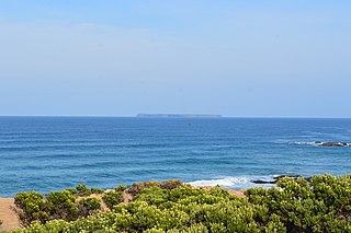
Lady Julia Percy Island, known as Deen Maar or Dhinmar in the Gunditjmara language, lies 8.1 kilometres (5.0 mi) off the coast, in the Barwon South West region of Victoria, Australia in Bass Strait. The island is an unincorporated area under the direct administration of the Government of Victoria.
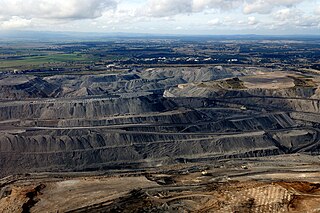
Coal is mined in every state of Australia. The largest black coal resources occur in Queensland and New South Wales. About 70% of coal mined in Australia is exported, mostly to eastern Asia, and of the balance most is used in electricity generation. In 2019-20 Australia exported 390 Mt of coal and was the world's largest exporter of metallurgical coal and second largest exporter of thermal coal. While only employing 50,000 mining jobs nationally coal provides a rich revenue stream for governments.
Yambuk is a small town in Victoria, Australia. The Yambuk township was established in the 1850s, and the Post Office opened on 1 March 1859. Yambuk is sited where the Princes Highway crosses the Shaw River. At the 2006 census, the town and surrounding area had a population of 540. The 2016 census recorded a population of 267.
Caramut is a town in the Western District of Victoria, Australia on the Hamilton Highway. It is in the Shire of Moyne local government area and the federal Division of Wannon.
Hexham is a township in Victoria, Australia.

Garvoc is a town in the Western District of Victoria, Australia. The town is located in the Moyne Shire local government area, 223 kilometres (139 mi) south west of the state capital, Melbourne.

The Twelve Apostles Marine National Park is a protected marine national park located on the south-west coast of Victoria, Australia. The 7,500-hectare (19,000-acre) marine park is situated near Port Campbell and is named after the scenic Twelve Apostles rock stacks, and contains the wreck of the clipper Loch Ard, wrecked on Mutton Bird Island in 1878. The marine park borders Port Campbell and Great Otway National Parks.

Michael Sven Sukkar is an Australian politician has served as the Shadow Minister for Housing, NDIS, and Social Services since 2022. Previously he had served as Assistant Treasurer and Minister for Housing and as the Minister for Homelessness, Social and Community Housing. Sukkar has been a member of the House of Representatives since September 2013, representing the Division of Deakin in Victoria for the Liberal Party.
Cathrine Mary Burnett-Wake is a former Australian politician, who was a member of the Victorian Legislative Council for the Eastern Victoria Region representing the Liberal Party between December 2021 and November 2022. Burnett-Wake was appointed by a joint sitting of the Victorian Parliament on 2 December 2021 to fill a vacancy brought about by the resignation of Edward O'Donohue. She is the first Liberal female upper house member for Eastern Victoria.