
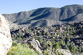
Tikaboo Valley is a valley in Lincoln County, Nevada, United States. Its geographical coordinates are 37.1563494 and -115.4016881. [1] It has an elevation of 3,793 feet or 1,156 meters. [2]
Tikaboo Valley is a valley in Lincoln County, Nevada, United States. Its geographical coordinates are 37.1563494 and -115.4016881. [1] It has an elevation of 3,793 feet or 1,156 meters. [2]
The climate there is dry, even on cool mornings after a rainfall. [3]
Biologist Chris Smith has studied flora and fauna in the area including Joshua trees and moths. [4] It appears that this may be the only place where two types of Joshua tree, namely the Eastern and Western varieties have come together. Part of the reason for this is the possibility of Climate change which could account for the northward appearance of a hybridized species. [5]
B-52H and B-1B Bombers often do low-level runs there. There have been other military tests there.

Yosemite National Park is an American national park located in the western Sierra Nevada of Central California, bounded on the southeast by Sierra National Forest and on the northwest by Stanislaus National Forest. The park is managed by the National Park Service and covers an area of 748,436 acres and sits in four counties: centered in Tuolumne and Mariposa, extending north and east to Mono and south to Madera County. Designated a World Heritage site in 1984, Yosemite is internationally recognized for its granite cliffs, waterfalls, clear streams, giant sequoia groves, lakes, mountains, meadows, glaciers, and biological diversity. Almost 95% of the park is designated wilderness.

The Sierra Nevada is a mountain range in the Western United States, between the Central Valley of California and the Great Basin. The vast majority of the range lies in the state of California, although the Carson Range spur lies primarily in Nevada. The Sierra Nevada is part of the American Cordillera, an almost continuous chain of mountain ranges that forms the western "backbone" of the Americas.

Yucca brevifolia is a plant species belonging to the genus Yucca. It is tree-like in habit, which is reflected in its common names: Joshua tree, yucca palm, tree yucca, and palm tree yucca.

The Great Basin is the largest area of contiguous endorheic watersheds in North America. It spans nearly all of Nevada, much of Oregon and Utah, and portions of California, Idaho, and Wyoming. It is noted for both its arid climate and the basin and range topography that varies from the North American low point at Badwater Basin in Death Valley to the highest point of the contiguous United States, less than 100 miles (160 km) away at the summit of Mount Whitney. The region spans several physiographic divisions, biomes, ecoregions, and deserts.

The Mojave Desert is an arid rain-shadow desert and the driest desert in North America. It is in the North American Southwest, primarily within southeastern California and southern Nevada, and it occupies 47,877 sq mi. Small areas also extend into Utah and Arizona. Its boundaries are generally noted by the presence of Joshua trees, which are native only to the Mojave Desert and are considered an indicator species, and it is believed to support an additional 1,750 to 2,000 species of plants. The central part of the desert is sparsely populated, while its peripheries support large communities such as Las Vegas, Barstow, Lancaster, Palmdale, Victorville, and St. George.

The Great Basin Desert is part of the Great Basin between the Sierra Nevada and the Wasatch Range. The desert is a geographical region that largely overlaps the Great Basin shrub steppe defined by the World Wildlife Fund, and the Central Basin and Range ecoregion defined by the U.S. Environmental Protection Agency and United States Geological Survey. It is a temperate desert with hot, dry summers and snowy winters. The desert spans a large part of the state of Nevada, and extends into western Utah, eastern California, and Idaho. The desert is one of the four biologically defined deserts in North America, in addition to the Mojave, Sonoran, and Chihuahuan Deserts.

The tree line is the edge of the habitat at which trees are capable of growing. It is found at high elevations and high latitudes. Beyond the tree line, trees cannot tolerate the environmental conditions. The tree line is sometimes distinguished from a lower timberline or forest line, which is the line below which trees form a forest with a closed canopy.

Rachel is a census-designated place (CDP) in Lincoln County, Nevada, United States. As of the 2010 census it had a population of 54. As the closest habitation to the Nellis Air Force Range and Area 51, Rachel enjoys a modest celebrity status, particularly among aviation enthusiasts and UFO hunters.

Eastern California is a region defined as either the strip to the east of the crest of the Sierra Nevada or as the easternmost counties of California.

The Desert National Wildlife Refuge is a protected wildlife refuge, administered by the U.S. Fish and Wildlife Service, located north of Las Vegas, Nevada, in northwestern Clark and southwestern Lincoln counties, with much of its land area lying within the southeastern section of the Nevada Test and Training Range. The Desert NWR, created on May 20, 1936, is the largest wildlife refuge in the lower 48 states of the United States, encompassing 1.615 million acres (6,540 km2) of the Mojave Desert in the southern part of Nevada. This Range is part of the larger Desert National Wildlife Refuge Complex, which includes the Ash Meadows National Wildlife Refuge, the Moapa Valley National Wildlife Refuge, and the Pahranagat National Wildlife Refuge.

Alamo is an unincorporated town in Lincoln County, Nevada, United States, about 90 miles (140 km) north of Las Vegas along U.S. Route 93. Its elevation is 3,449 feet (1,051 m). As of the 2010 census it had a population of 1,080.
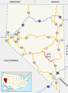
State Route 375 is a 98.414-mile (158.382 km) state highway in Nye and Lincoln counties in south-central Nevada, United States. The highway stretches from State Route 318 at Crystal Springs northwest to U.S. Route 6 at Warm Springs. The route travels through mostly unoccupied desert terrain, with much of its alignment paralleling the northern edges of the Nellis Air Force Range. The road originally traversed through what is now the northern reaches of the air force range in the 1930s, when it was previously designated State Route 25A and later part of State Route 25.
U.S. Route 50 (US 50) is a transcontinental highway in the United States, stretching from West Sacramento, California, in the west to Ocean City, Maryland, on the east coast. The Nevada portion crosses the center of the state and was named The Loneliest Road in America by Life magazine in July 1986. The name was intended as a pejorative, but Nevada officials seized it as a marketing slogan. The name originates from large desolate areas traversed by the route, with few or no signs of civilization. The highway crosses several large desert valleys separated by numerous mountain ranges towering over the valley floors, in what is known as the Basin and Range province of the Great Basin.

The Sierra Nevada subalpine zone refers to a biotic zone below treeline in the Sierra Nevada mountain range of California, United States. This subalpine zone is positioned between the upper montane zone at its lower limit, and tree line at its upper limit.

The Lower Colorado River Valley (LCRV) is the river region of the lower Colorado River of the southwestern United States in North America that rises in the Rocky Mountains and has its outlet at the Colorado River Delta in the northern Gulf of California in northwestern Mexico, between the states of Baja California and Sonora. This north–south stretch of the Colorado River forms the border between the U.S. states of California/Arizona and Nevada/Arizona, and between the Mexican states of Baja California/Sonora.

Joshua Tree National Park is an American national park in southeastern California, east of Los Angeles and San Bernardino, near Palm Springs. The park is named for the Joshua trees native to the Mojave Desert. Originally declared a national monument in 1936, Joshua Tree was redesignated as a national park in 1994 when the U.S. Congress passed the California Desert Protection Act. Encompassing a total of 790,636 acres —an area slightly larger than the state of Rhode Island—the park includes 429,690 acres of designated wilderness. Straddling the border between San Bernardino County and Riverside County, the park includes parts of two deserts, each an ecosystem whose characteristics are determined primarily by elevation: the higher Mojave Desert and the lower Colorado Desert. The Little San Bernardino Mountains traverse the southwest edge of the park.
The Sylvania Mountains Wilderness is a federally designated wilderness area located 30 miles (48 km) east of Bishop in the state of California. The wilderness is 18,677acres in size and is managed by the Bureau of Land Management (BLM). The California Desert Protection Act of 1994 created the Sylvania Mountains Wilderness and was added to the National Wilderness Preservation System. The wilderness is bordered by Nevada stateline on the east, Piper Mountain Wilderness on the west and Death Valley National Park to the south.
The Mount Irish Range is a mountain range in Lincoln County, Nevada. The range is bounded by the Coal Valley to the north, the Pahranagat Valley to the east, the Tikaboo Valley to the southwest and the Wild Horse Valley to the northwest. Surrounding ranges include the Seaman Range and Hiko Range to the east, the Pahranagat Range and East Pahranagat Range to the south and south east, the Groom Range to the southwest, the Timpahute Range to the west and the Golden Gate Range across Murphy Gap to the northwest.

Indian Springs Valley is one of the Central Nevada Desert Basins in the Clark County portion of the Nevada Test and Training Range and includes Creech Air Force Base and the communities of Cactus Springs and Indian Springs, Nevada. The south side of the valley is along the "Las Vegas Valley Shear Zone", and to the east is the Pintwater Range, to the southeast is the Las Vegas Valley, to the south are foothills near the Spring Mountains, to the southwest is Mercury Valley, and to the west is the Spotted Range. The valley's drainage basin receives ~500 acre feet (620,000 m3) of annual precipitation and is a southern portion of the Sand Springs-Tikaboo Watershed where it meets the Ivanpah-Pahrump Watershed. The Wheeler Survey in 1869 passed through the Indian Springs Valley.
Montane ecosystems are found on the slopes of mountains. The alpine climate in these regions strongly affect the ecosystem because temperatures fall as elevation increases, causing the ecosystem to stratify. Dense montane forests are common at moderate elevations, due to moderate temperatures and high rainfall. At higher elevations, the climate is harsher, with lower temperatures and higher winds, preventing the growth of trees and causing the plant community to transition to montane grasslands, shrublands or alpine tundra.
![]()