
The following is a timeline of the history of the city of Melbourne , Victoria, Australia.
The following is a timeline of the history of the city of Melbourne , Victoria, Australia.


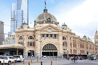
Flinders Street railway station is a train station located on the corner of Flinders and Swanston streets in Melbourne, Victoria, Australia. It is the second busiest train station in Australia, serving the entire metropolitan rail network, 15 tram routes travelling to and from the city, as well as some country and regional V/Line services to eastern Victoria. Opened in 1854, the station is the oldest in Australia, backing onto the Yarra River in the central business district, the complex includes 13 platforms and structures that stretch over more than two city blocks, from east of Swanston Street to nearly at Market Street.

The City Loop is a piece of underground commuter rail infrastructure in the central business district (CBD) of Melbourne, Victoria, Australia

Docklands, also known as Melbourne Docklands, is an inner-city suburb in Melbourne, Victoria, Australia, 2 km (1.2 mi) west of Melbourne's Central Business District, located within the City of Melbourne local government area. Docklands recorded a population of 15,495 at the 2021 census.

Southbank is an inner-city suburb in Melbourne, Victoria, Australia, 1 km south of the Melbourne central business district, located within the Cities of Melbourne and Port Phillip local government areas. Southbank recorded a population of 22,631 at the 2021 census.
Batman railway station is located on the Upfield line in Victoria, Australia. It serves the northern Melbourne suburb of Coburg North and it on 8 October 1889 as Bell Park. It closed on 13 July 1903, and reopened on 1 October 1914 as Batman.
Victoria Park railway station is located on the Mernda and Hurstbridge lines in Victoria, Australia. It serves the north-eastern Melbourne suburb of Abbotsford, and it opened on 8 May 1888 as Collingwood. It was renamed Victoria Park on 1 May 1909.
The Melbourne rail network is a metropolitan suburban and freight rail system serving the city of Melbourne, Victoria, Australia. The metropolitan rail network is centred around the Melbourne central business district (CBD) and consists of 222 railway stations across 16 lines, which served a patronage of 99.5 million over the year 2021–2022. It is the core of the larger Victorian railway network, with regional links to both intrastate and interstate rail systems.

Flinders Street is a street in Melbourne, Victoria, Australia. Running roughly parallel to the Yarra River, Flinders Street forms the southern edge of the Hoddle Grid. It is exactly 1 mi (1.6 km) in length and one and a half chains in width.

Melbourne tram route 70 is operated by Yarra Trams on the Melbourne tram network from Waterfront City to Wattle Park. The 16.5 kilometre route is operated out of Camberwell depot with A and B class trams.
Spencer Street is a major street and thoroughfare in the Melbourne central business district, Victoria, Australia. The street was gazetted in 1837 as the westernmost boundary of the Hoddle Grid.
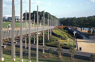
Birrarung Marr is an inner-city park between the central business district in Melbourne, Victoria, Australia and the Yarra River. It was opened in 2002. The name refers to the bank of Birrarung, the 'river of mists', in the Woiwurrung language of the Wurundjeri people, the Indigenous inhabitants at the time of European colonisation of the Melbourne area.

Melbourne is Australia's second largest city and widely considered to be a garden city, with Victoria being nicknamed "the Garden State". Renowned as one of the most livable cities in the world, there is an abundance of parks, gardens and green belts close to the CBD with a variety of common and rare plant species amid landscaped vistas, pedestrian pathways, and tree-lined avenues, all managed by Parks Victoria.
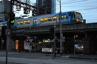
Transport in Melbourne, the state capital of Victoria, Australia, consists of several interlinking modes. Melbourne is a hub for intercity, intracity and regional travel. Road-based transport accounts for most trips across many parts of the city, facilitated by Australia's largest freeway network. Public transport, including the world's largest tram network, trains and buses, also forms a key part of the transport system. Other dominant modes include walking, cycling and commercial-passenger vehicle services such as taxis.

Princes Bridge, originally Prince's Bridge, is a bridge in central Melbourne, Australia that spans the Yarra River. It is built on the site of one of the oldest river crossings in the city, and forms a gateway into the central city from the south. The bridge connects Swanston Street on the north bank of the Yarra River to St Kilda Road on the south bank, and carries road, tram and pedestrian traffic. The present bridge was built in 1888 and is listed on the Victorian Heritage Register.
The Port Melbourne railway line is a former railway line in Melbourne, Australia, opened in September 1854, that is now a light rail line. It was instigated by the Melbourne and Hobson's Bay Railway Company to carry passengers arriving in Victoria at Station Pier and to alleviate the high cost of shipping goods using small vessels up the Yarra River to Melbourne. The line's conversion to light rail occurred in 1987; it is now served by tram route 109.

The Melbourne central business district is the city centre and main urban area of the city of Melbourne, Victoria, Australia, centred on the Hoddle Grid, the oldest part of the city laid out in 1837, and includes its fringes. The Melbourne CBD is located in the local government area of the City of Melbourne which also includes some of inner suburbs adjoining the CBD.

Jolimont Yard was an array of railway lines and carriage sidings on the edge of the central business district of Melbourne, Australia. Located between Flinders Street station, Richmond Junction, the Yarra River and Flinders Street they were often criticised for cutting off the city from the river, being the site of many redevelopment proposals. The Princes Gate Towers were built over part of the yard in the 1960s, which themselves were replaced by Federation Square in the 2000s. The rail sidings themselves were progressively removed from the 1980s to the 1990s with only running lines today, but the area continues to be referred to as the 'Jolimont railyards' by Melburnians.

The Metro Tunnel is a metropolitan rail rapid transit project currently under construction in Melbourne, Victoria, Australia. It includes the construction of twin 9-kilometre (5.6 mi) rail tunnels between South Kensington and South Yarra with five new underground stations. The tunnel will connect the Pakenham and Cranbourne lines with the Sunbury line, creating a new cross-city line that bypasses Flinders Street station and the City Loop. The line is also planned to serve Melbourne Airport via a new branch line west of Sunshine station.

The architecture of Melbourne, the capital of the state of Victoria and second most populous city in Australia, is characterised by a wide variety of styles dating from the early years of European settlement to the present day. The city is particularly noted for its mix of Victorian architecture and contemporary buildings, with 74 skyscrapers in the city centre, the most of any city in the Southern Hemisphere.
The Melbourne tram network began in 1884 with the construction of the Fairfield Horse Tramway. However, the purpose of the line was to increase land prices in the area, and it soon closed during the depression in 1890. The first genuine attempt to construct a tramway network was the construction of the Richmond cable tram line by the Melbourne Tramway & Omnibus Company in 1885. Over the next few years, 16 more cable tram lines were constructed, as well as numerous other horse tramways. The depression of the early 1890s slowed further expansion of the cable network. The first electric tram line was the Box Hill and Doncaster tramway which opened in 1889. This was a pioneering line in what was then the countryside and thus didn't receive much patronage. It closed in 1896. The next attempt at an electric tramway was Victorian Railways' St Kilda to Brighton line, which opened in 1906. Later that year, the North Melbourne Electric Tramway & Lighting Company opened lines to Essendon and Maribyrnong. Many local councils formed their own tramway trusts and built tramways within their own constituency. The most successful of these was the Prahran & Malvern Tramways Trust.