| History of Israel |
|---|
 |
The following is a timeline of the history of the city of Tel Aviv, Israel.
| History of Israel |
|---|
| |
The following is a timeline of the history of the city of Tel Aviv, Israel.

| | This section needs expansion. You can help by adding to it. (May 2020) |

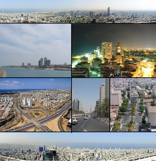
Tel Aviv-Yafo, usually referred to as just Tel Aviv, is the most populous city in the Gush Dan metropolitan area of Israel. Located on the Israeli Mediterranean coastline and with a population of 467,875, it is the economic and technological center of the country. If East Jerusalem is considered part of Israel, Tel Aviv is the country's second-most-populous city, after Jerusalem; if not, Tel Aviv is the most populous city, ahead of West Jerusalem.
Gush Dan or Tel Aviv metropolitan area is a conurbation in Israel, located along the country's Mediterranean coastline. There is no single formal definition of Gush Dan, though the term is in frequent use by both governmental bodies and the general public. It ranges from combining Tel Aviv with cities that form an urban continuum with it to the entire areas from both the Tel Aviv and the Central District or sometimes the whole Metropolitan Area of Tel Aviv, which includes a small part of the Southern District as well. Gush Dan is the largest conurbation and metropolitan area in Israel, with the metropolitan area having an estimated population of 4,156,900 residents, 89% of whom are Israeli Jews.
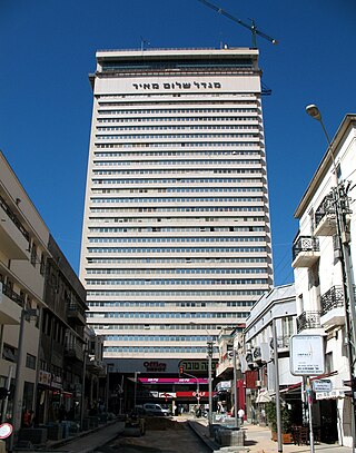
Shalom Meir Tower is an office tower in Tel Aviv, Israel. It is Israel's first skyscraper.

Independence Hall, originally the Dizengoff House is the site of the signing of Israel's Declaration of Independence. It is located on the historic Rothschild Boulevard in Tel Aviv, Israel. From 1932 to 1971 housing the Tel Aviv Museum of Art, it is currently a museum dedicated to the signing of the Israeli Declaration of Independence and the history of Tel Aviv.

Nachum Gutman was a Moldovan-born Israeli painter, sculptor, and author.

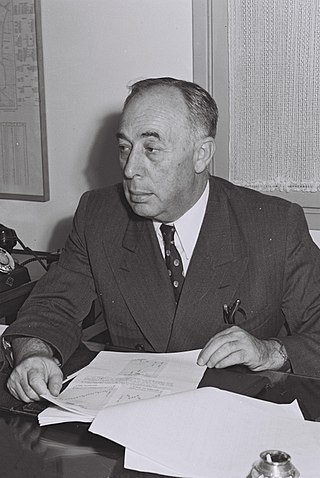
Meir Dizengoff was a Zionist leader and politician and the founder and first mayor of Tel Aviv. Dizengoff's actions in Ottoman Palestine and the British Mandate for Palestine helped lead to the creation of the State of Israel. David Ben-Gurion declared Israeli independence in 1948 at Dizengoff's residence in Tel Aviv. Dizengoff House is now Israel's Independence Hall.
Kerem HaTeimanim is a neighborhood in the center of Tel Aviv, Israel. The neighborhood is adjacent to the Carmel Market.

Neve Tzedek is a neighborhood located in southwestern Tel Aviv, Israel. It was the first Jewish neighborhood to be built outside the old city of the ancient port of Jaffa. Originally it was a Sephardi Jewish neighbourhood. Since the 1990s, rundown properties have been restored and it is now a fashionable quarter of Tel Aviv.
The city of Tel Aviv-Yafo is subdivided into four quarters, which are further divided into neighborhoods.
Israel Rokach, Honorary CBE was an Israeli politician, Knesset member, and fourth mayor of Tel Aviv from November 15, 1936 until April 13, 1953.

The Tel Aviv transportation system is seen as the hub of the Israeli transport network in terms of road, rail, and air transport. The Israeli road network partly centers on Tel Aviv, with some of the country's largest highways passing through or running to the city. The city forms a major part of the country's rail network, whilst Ben Gurion International Airport located near the city is the country's largest airport. There is also a strong public transport system within the city, based primarily on bus transportation.

Dizengoff Center is a shopping mall at the intersection of Dizengoff Street and King George Street in Tel Aviv, Israel. The mall is named for Meir Dizengoff, the first mayor of Tel Aviv.

Begin Road is a major thoroughfare in Tel Aviv, Israel. It begins at Allenby Street and runs to its northern end which is at Arlozorov Interchange on Ayalon Highway.

The Suzanne Dellal Centre for Dance and Theatre is a centre for dance in Israel, located in Neve Tzedek, Tel Aviv.
Neve Shalom is a cooperative village in Israel.
Koidanov is a Hasidic dynasty originating from the city of Dzyarzhynsk (Koidanov), Belarus, where it was founded by Rabbi Shlomo Chaim Perlow in 1833. Koidanov is a branch of both Lechovitch Hasidism and Karlin-Stolin Hasidism as Rabbi Shlomo Chaim Perlow was the paternal grandson of Rabbi Mordechai of Lechovitch and the maternal grandson of Rabbi Asher of Stolin. Koidanov was the smallest of the three Lithuanian Hasidic dynasties, with most of its Hasidim being murdered in the Holocaust. The dynasty was re-established after the war in Tel Aviv, then moved to Bnei Brak, where the majority of the dynasty is located, but there are Chassidim located around the world.
Neve Shalom is an historic neighborhood in Tel Aviv, Israel. It was established by Zerah Barnett in 1890 outside the walls of Jaffa and named after Isaiah 32:18: "My people will live in a dwelling place of peace."

Ohel Moshe was a Jewish neighborhood which located Eastern-Northern to Jaffa, established in 1906. it was founded by Moshe Asulin, Moshe Elbaz and Moshe Attia, therefore its name. The neighborhood was inhabited mainly by Maghrebi Jews, with small numbers of Ashkenazi Jews and Yemenite Jews. It grew quickly and by 1922 its population was 936 inhabitants, living in 82 houses. In the 1920s, it has merged with Tel Aviv municipality.

Tel Aviv-Yafo Municipality is the arm of local government responsible for the administration of the Israeli city of Tel Aviv-Yafo. Tel Aviv-Yafo Municipality handles such municipal affairs as education, culture, social welfare, infrastructure, urban planning and sanitation. The current head of the municipality is Ron Huldai.
Ha-Tomer is an art cooperative that operated in 1920 in Tel Aviv-Yafo. Its members were among the first to support and implement modernist art in Israel.
This article incorporates information from the Hebrew Wikipedia, Polish Wikipedia, and French Wikipedia.