Times Atlas of the World

Last updated

First (1895) edition TheTimesAtlas.jpg
First (1895) edition

The Times Atlas of the World, rebranded The Times Atlas of the World: Comprehensive Edition in its 11th edition and The Times Comprehensive Atlas of the World from its 12th edition, is a world atlas currently published by HarperCollins Publisher L.L.C. Its most recent edition, the sixteenth, was published on October 12th, 2023.

Contents

Editions

First generation

The first version of The Times Atlas of the World appeared as The Times Atlas in 1895; more printings followed up to 1900. It was published at the office of The Times newspaper in London, and contained 117 pages of maps with an alphabetical index of 130,000 names. The atlas was a reprint of Cassell & Co.'s Universal Atlas, published in 1893. Cassell's atlas, in turn, used maps in English printed in Leipzig which were drawn from the second edition (1887; with some maps of the third edition (1893)) of the German Andrees Allgemeiner Handatlas from the publisher Velhagen & Klasing. [1]

Second generation

The second generation of the atlas was issued in 1922 as The Times Survey Atlas of the World and was prepared at the Edinburgh Geographical Institute under the direction of John George Bartholomew. It contained 112 double page maps with 200,000 names, and measured 47 cm × 33 cm.

Third generation

The third generation, based on the second, was Bartholomew's famous five-volume set of 19"×12" elephant folio atlases with 120 plates in eight colors, most maps being double page, and over 200,000 names. The set was issued from 1955–59 as The Times Atlas of the World. Mid-Century Edition by The Times Publishing Company Ltd. in London, (Volume One: The World, Australasia & East Asia. Volume Two: South-West Asia & Russia. Volume Three: Northern Europe. Volume Four: Southern Europe & Africa. Volume Five: The Americas; however, volumes III-V were in fact published first.) A July, 1957 advertisement for The Americas volume suggested that the maps included the latest places of note: "the St. Lawrence Seaway, the newest Federal and Interstate highway systems, ... rocket-launching sites and Atomic Energy installations."

In 1967, an edition in one volume (in which the maps were printed back-to-back – some on a fractionally smaller scale) was published as The Times Atlas of the World. Comprehensive Edition (with 123 leaves of maps in the 9th edition of 1992). This edition also appeared in a German, a Dutch and a French translation. Its introduction reads: "The successor to [the Mid-Century Edition] in one volume, nevertheless, this work contains greater detail, as well as considerable additional material, with no loss of scale, this being achieved by printing on both sides of the paper, using narrower margins, and including a single index. Some revisions and improvements were made; endpaper keys show which parts of the world are covered by which plates; an international glossary gives the English equivalents of common name-words. Some discoveries by satellite surveys were included."

Fourth generation

The 10th or "Millennium" edition (1999) of the 1967 Comprehensive Edition is in effect the first representative of the fourth generation. In contrast to its predecessors, it is completely produced by means of computer-cartography: The Times Comprehensive Atlas of the World, published by Times Books in London (124 leaves of maps). Contents are slightly different in scale, or in arrangement.

10th edition (1999)

According to the publisher, this "was the first entirely new edition of the atlas since the Mid-Century Edition and also the first to be produced from digital data." [2]

11th edition (2003)

This edition was also offered, bound in half-leather, by the Folio Society.

12th edition (2007)

Changes to previous editions include "an estimated 20,000 mapping updates including 3,500 changes to names, a brand new map of Alaska and NW Canada, abandoned settlements featured for the first time, new satellite images of the continents, revision of all national and socio-economic statistics and new coverage on Biodiversity and the Environment ... The division of Serbia and Montenegro into separate countries. The new national capital of Myanmar called Nay Pyi Taw, a joint capital with Yangon (Rangoon). Secession of St-Barthelemy and St-Martin from Guadeloupe. New World Heritage Sites. Opening of the 1118 km Golmud to Lhasa railway in China, the highest railway in the world. Opening of the 32.5 km cross sea Donghai bridge, in China, linking Shanghai to the deepwater port on Xiaoyang Shan island." [3]

A Luxury Edition was also offered from 2008, bound by Book Works Studio in London.

13th edition (2011)

The map of Greenland depicted 15% less ice cover than in the 1999 edition. A number of glaciologists and climate scientists contested the claim. [4] [5] Researchers from the Scott Polar Research Institute wrote: "A sizable portion of the area mapped as ice-free in the Atlas is clearly still ice-covered. There is to our knowledge no support for this claim in the published scientific literature. It's a really bad mapping error." [6] The publishers accepted that "the map did not meet the usual high standards of accuracy and reliability that The Times Atlas of the World strives to uphold" and designed a new map that is now included as an insert in the atlas; it is also available for free download. [7]

14th edition (2014)

Changes to the new edition include "5000 place name changes, most notably in Japan, Brazil, South Korea, Taiwan and Spain. Updated national parks and conserved areas including the Kavango Zambezi Transfrontier Conservation Area (KAZA TFCA), the largest conservation zone in the world. Addition of over 50 major waterfalls around the world." [8] [ sic ] Geopolitical changes include "Realignment of a section of the international boundary between Burkina Faso and Niger resulting from the International Court of Justice decision. New administrative structures in Burkina Faso, Côte d'Ivoire, Kenya and Madagascar, and the addition of the long proposed new Indian state of Telangana. Updated population of Brazilian towns from new census information. Disputed boundary around Crimea." [8]

New features include "New maps of the sub-ice features in the Antarctic and Arctic Ocean. Physical maps of all the continents showing land features which offer a useful counterpoint to political mapping. Illustrated articles on Biodiversity and Climate Change. The Power of Maps – this new section illustrates the influence maps have had on all our lives." [9]

15th edition (2018)

16th edition (2023)

New features include [10] :
• New country names for Eswatini (formerly Swaziland) and North Macedonia (previously the Former Yugoslav Republic of Macedonia)
• More than 8000 place name changes with names comprehensively updated in Kazakhstan and Ukraine
• Addition of Māori names in New Zealand and restored indigenous names in Australia, the most notable being the renaming of Fraser Island in Queensland to its Butchulla name K’gari
• Administrative boundary updates in Ethiopia, Mali, and Kazakhstan
• Added road, railway and airport infrastructure across the globe including the 4km-long Dardanelles Bridge (Turkey), the Fehmarn Belt road/rail tunnel alignment (Germany/Denmark) and the Sandoy Tunnel (Faroe Islands)

Related Research Articles

<span class="mw-page-title-main">Burkina Faso</span> Country in West Africa

Burkina Faso is a landlocked country in West Africa with an area of 274,223 km2 (105,878 sq mi), bordered by Mali to the northwest, Niger to the northeast, Benin to the southeast, Togo and Ghana to the south, and Ivory Coast to the southwest. As of 2021, the country had an estimated population of 20,321,378. Previously called Republic of Upper Volta (1958–1984), it was renamed Burkina Faso by President Thomas Sankara. Its citizens are known as Burkinabè, and its capital and largest city is Ouagadougou. Its name is often translated into English as the "Land of Honest Men".

<span class="mw-page-title-main">Jan Janssonius</span> Dutch cartographer and publisher

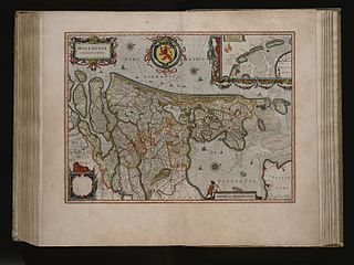
Johannes Janssonius was a Dutch cartographer and publisher who lived and worked in Amsterdam in the 17th century.

<span class="mw-page-title-main">Glaciology</span> Scientific study of ice and natural phenomena involving ice

Glaciology is the scientific study of glaciers, or more generally ice and natural phenomena that involve ice.

<i>The Atlas of Middle-earth</i> 1981 book by Karen Wynn Fonstad

The Atlas of Middle-earth by Karen Wynn Fonstad is an atlas of J. R. R. Tolkien's fictional realm of Middle-earth. It was published in 1981, following Tolkien's major works The Hobbit, The Lord of the Rings, and The Silmarillion. It provides many maps at different levels of detail, from whole lands to cities and individual buildings, and of major events like the Battle of the Pelennor Fields. The maps are grouped by period, namely the First, Second, and Third Ages of Middle-earth, with chapters on The Hobbit and The Lord of the Rings. A final chapter looks at geographic themes such as climate, vegetation, population, and languages around Middle-earth.

<span class="mw-page-title-main">August Heinrich Petermann</span> German cartographer (1822–1878)

Augustus Heinrich Petermann was a German cartographer.

Collins Bartholomew, formerly John Bartholomew and Son, is a long-established map publishing company originally based in Edinburgh, Scotland. It is now a subsidiary of HarperCollins.

<span class="mw-page-title-main">Alexander Keith Johnston (1804–1871)</span> Scottish geographer and cartographer

Alexander Keith Johnston FRSE FRGS FGS FEGS LLD was a Scottish geographer and cartographer.

<i>Atlas Maior</i> Atlas by Joan Blaeu

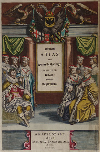
The Atlas Maior is the final version of Joan Blaeu's atlas, published in Amsterdam between 1662 and 1672, in Latin, French, Dutch, German and Spanish, containing 594 maps and around 3,000 pages of text. It was the largest and most expensive book published in the seventeenth century. Earlier, much smaller versions, titled Theatrum Orbis Terrarum, sive, Atlas Novus, were published from 1634 onwards. Like Abraham Ortelius's Theatrum Orbis Terrarum (1570), the Atlas Maior is widely considered a masterpiece of the Golden Age of Dutch/Netherlandish cartography.

<i>The Times Atlas of World History</i>

The Times Atlas of World History is a historical atlas first published by Times Books Limited, then a subsidiary of Times Newspapers Ltd and later a branch of Collins Bartholomew, which is a subsidiary of HarperCollins, and which in the latest editions has changed names to become The Times Complete History of the World. The first two editions were created by Barry Winkleman, the editorial director of Times Atlases and Managing Director of Times Books. They were edited by the Oxford Chichele Professor of Modern History Geoffrey Barraclough. It contains large full color plates and commentary on each map or set of maps. Includes approximately 600 maps covering the date span of 3000 BCE to 1975. It has been revised and reprinted for many times and the latest edition is the ninth edition, published in 2015, and reflects on the modern world up to the 21st Century.

<span class="mw-page-title-main">John George Bartholomew</span> British cartographer and geographer

John George Bartholomew was a British cartographer and geographer. As a holder of a royal warrant, he used the title "Cartographer to the King"; for this reason he was sometimes known by the epithet "the Prince of Cartography".

<i>Barrington Atlas of the Greek and Roman World</i> Large-format English language atlas

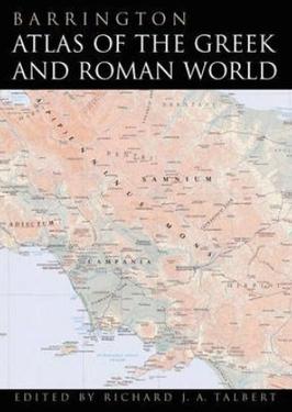
The Barrington Atlas of the Greek and Roman World is a large-format English language atlas of ancient Europe, Asia, and North Africa, edited by Richard J. A. Talbert. The time period depicted is roughly from archaic Greek civilization through Late Antiquity. The atlas was published by Princeton University Press in 2000. The book was the winner of the 2000 Association of American Publishers Award for Best Professional/Scholarly Multivolume Reference Work in the Humanities.

<span class="mw-page-title-main">Joan Blaeu</span> Dutch cartographer (1596–1673)

Joan Blaeu was a Dutch cartographer born in Alkmaar, the son of cartographer Willem Blaeu.

<span class="mw-page-title-main">Uunartoq Qeqertaq</span> Island off the coast of Greenland

Uunartoq Qeqertaq (Greenlandic), Warming Island in English, is an island off the east central coast of Greenland, 550 kilometres north of the Arctic Circle. It became recognised as an island only in September 2005, by US explorer Dennis Schmitt. It was attached to the mainland of Liverpool Land by glacial ice even in 2002, when the ice shelves began retreating rapidly in this area, so that by 2005 it was no longer attached to the mainland. Members of the scientific community believe this newly discovered island is a direct result of global warming.

The Nicholson Guides are a set of books originally published by Robert Nicholson Publications, then jointly by Bartholomew and the Ordnance Survey, and now by HarperCollins, as guides to the navigable and un-navigable waterways of England and Wales.

<span class="mw-page-title-main">Rail transport in Burkina Faso</span>

There are 622 kilometres of 1,000 mmmetre gauge railway in Burkina Faso, which run from Kaya to the border with Côte d'Ivoire and is part of the Abidjan-Ouagadougou railway. As of June 2014, 'Sitarail' operates a passenger train three times a week along the route from Ouagadougou to Abidjan. Journey time is 43 to 48 hours.

<span class="mw-page-title-main">Geographers' A–Z Map Company</span> British independent map publisher

Geographers' A–Z Map Company Ltd. is the largest independent map publisher in the United Kingdom, providing cartographic services, digital data products and paper mapping publications.

<span class="mw-page-title-main">John Francon Williams</span> British writer, geographer, historian, journalist, cartographer and inventor

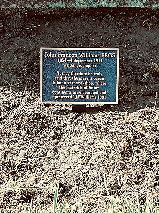
John Francon Williams was a British writer, geographer, historian, journalist, cartographer, and inventor, born in Llanllechid, Caernarvonshire. His seminal work was The Geography of the Oceans.

References

  1. Espenhorst, Jürgen (2003). Petermann's Planet, vol. 1. Pangaea Verlag. pp. 610–613. ISBN   978-3-930401-35-2.
  2. The Times Comprehensive Atlas of the World (London: Times Books, 2005; p. [5])
  3. "Explore Times World Atlases and Maps over the last 100 years". Archived from the original on 23 April 2009. Retrieved 21 May 2009.
  4. Black, Richard (20 September 2011). "Greenland ice: Are the Times a-changing?". BBC News.
  5. Harvey, Fiona (20 September 2011). "Times Atlas publishers apologise for 'incorrect' Greenland ice statement". The Guardian.
  6. "UPDATED: Atlas Shrugged? 'Outraged' Glaciologists Say Mappers Misrepresented Greenland Ice Melt". 19 September 2011. Archived from the original on 30 January 2013. Retrieved 9 April 2017.
  7. "A guide to how the Times World Atlas team developed new mapping of Greenland". Archived from the original on 18 January 2013. Retrieved 3 January 2013.
  8. 1 2 http://resources.collins.co.uk/Website%20images/TimesAtlas/PDF-BLAD.pdf [ dead link ]
  9. "The Times Comprehensive Atlas of the World".
  10. "The Times Comprehensive Atlas of the World".