Timor Gap Treaty

Last updated

Timor Gap Treaty
Treaty between Australia and The Republic of Indonesia on the Zone of Cooperation in an area between the Indonesian province of East Timor and Northern Australia
Timor gap blank.PNG
The Timor Gap
The Zone of Cooperation was divided into Area A (Pink), Area B (Yellow) and Area C (Red)
TypeBilateral Treaty
Signed11 December 1989 (1989-12-11)
Effective9 February 1991
Expiry20 May 2002
Original
signatories
Flag of Indonesia.svg Ali Alatas
Parties

The Timor Gap Treaty was formally known as the Treaty between Australia and the Republic of Indonesia on the zone of cooperation in an area between the Indonesian province of East Timor and Northern Australia. It was a bilateral treaty between the governments of Australia and Indonesia, which provided for the joint exploitation of petroleum and hydrocarbon resources in a part of the Timor Sea Seabed. [1] The treaty was signed on 11 December 1989 and came into force on 9 February 1991. [2] The signatories to the treaty were then Australian Foreign Affairs Minister Gareth Evans and then Indonesian Foreign Minister Ali Alatas. [3]

Contents

The Treaty has been the centre of much controversy as it was signed during a period of political uncertainty in East Timor. [2] In 1991, Portugal challenged the validity of the Treaty in the International Court of Justice but no case could be brought due to the Court's lack of jurisdiction. [4] The United Nations replaced Indonesia as a treaty party in 2000 after East Timor gained independence from Indonesia. [3] In 2002, the Timor Gap Treaty was replaced by the Timor Sea Treaty between the Government of East Timor and the Government of Australia. [5] In 2019, the Timor Sea Treaty was replaced by the Treaty Between Australia and the Democratic Republic of Timor-Leste Establishing Their Maritime Boundaries in the Timor Sea. [5]

Geography and Historical Context of the Treaty

The Timor Gap refers to the 60,000 square kilometre “coffin-shaped” area between Australia and East Timor. [6] The area contains several oil and gas reserves. The exact value of the resources contained in the Timor Gap is unknown, but three of the largest reserves, Elang-Kakatua, Bayu-Undan and Sunrise-Troubadour are estimated to hold US$17 billion worth of oil. [7]

The Timor Gap does not refer to any geographical landmark but is instead the area of continental shelf that was subject to negotiations between Indonesia, Australia and Portugal in the early 1970s. [6] In 1971-2 Indonesia and Australia delimited their seabed boundaries in the Timor Sea. [6] Australia attempted to negotiate with Portuguese Timor to come to a similar boundary agreement, but these negotiations remained inconclusive when Portugal withdrew from East Timor in 1975. [2] As a result, there was a break in the Australia-Indonesia boundary in the area surrounding East Timor. [2] This break is known as the Timor Gap.

On 7 December 1975, Indonesian forces invaded and annexed East Timor as its twenty-seventh province. [8] This was nine days after East Timor had declared its independence following Portugal withdrawing from the country. [8] The UN did not recognise Indonesia as the ruling force of East Timor and asserted Portugal as the administering authority of the nation. [9] Australia initially refused to acknowledge Indonesian control of East Timor. [2] However, in 1979 it gave de jure recognition of Indonesian occupation of the country, and began negotiations with Indonesia in relation to closing the Timor Gap. [2]

Controversy surrounding Australia's involvement in the Indonesian invasion in East Timor

The extent to which Australia knowingly allowed or encouraged Indonesia to invade East Timor has long attracted international debate. [9] Australia was the only western nation to recognise Indonesian rule. [7] It has been contended by commentators such as Noam Chomsky, [10] that Australia was motivated to support Indonesia due to the prospect of an eventual Timor Gap Treaty, which would have significant financial and resource benefits, [11] and enhance the nation's relationship with Indonesia and its foothold in Asia. [9]

Gareth Evans responded to these criticisms by asserting that Australia did not support the Indonesian invasion of East Timor, but had no power to stop Indonesia's invasion. [12] He stated that there was “nothing morally offensive” [12] about Australia's recognition of Indonesian sovereignty in East Timor as it never denied the right of self-determination of the East Timorese population. [12] He also argued that East Timor “was never disadvantaged by the Timor Gap Treaty”, [12] as it was always intended that East Timor would replace Indonesia in the Treaty if they emerged as an independent nation.

Formation and Signing of the Treaty

Indonesia and Australia held substantially different positions on how the Timor Gap should be delimited. Both positions were supported by conflicting sources of International Law, complicating the treaty making process. [2]

Australia proposed that the boundaries should be determined according to the Convention on the Continental Shelf 1958, which grants sovereignty to a nation over the continental shelf beyond their shores. [2] Australia contended that the Timor Trough marked the edge of its continental shelf, giving the nation sovereignty over a significant share of the Timor Gap pursuant to the Convention. [11] This position was upheld in the North Sea Continental Shelf Cases of 1969, where the International Court of Justice determined a state's continental shelf to be the “natural prolongation of its land territory”. [2]

Indonesia's position was based on the UN Convention on the Law of the Sea (UNCLOS) 1982, [2] which gives a state full and exclusive rights over the 200 nautical miles from its territorial sea baseline, even if its continental shelf is geographically much smaller (unless proved that the continental shelf extends beyond this 200 nautical miles). [13]

As neither party would concede, and an agreement on boundary lines could not be made, the parties instead agreed to a provisional arrangement in accordance to UNCLOS Article 83. [2] In 1985, the parties agreed on the ‘Zone of Cooperation’ which would allow them to jointly exploit the resources in the Timor Gap. [2] This arrangement was formalised on 11 December 1989 when the Timor Gap Treaty was signed by the Australian and Indonesian Foreign Ministers, Gareth Evans and Ali Alatas, during a flight over the Timor Gap. [14] The Zone of Cooperation has been “heralded as the most complex, comprehensive and sophisticated maritime joint development zone ever concluded”. [15]

Effect of the Treaty

The Timor Gap Treaty divided the Zone of Cooperation into three areas – Areas A, B and C. [3] It created a regime for an initial term of 40 years for the exploration of resources in these three areas. [3] Part II of the Treaty set out that Area B, the southern part of the Gap, was to be administered by Australia, with Indonesia entitled to 10 per cent of the Resource Rent Tax from petroleum revenues in the area. [16] Area C, the northern part of the Gap, was to be administered by Indonesia who had to provide 10 per cent of tax revenue from petroleum activities in the area to Australia. [16] Area A, the middle and largest portion of the Gap, was jointly administered by both parties and revenues were divided equally. The rights of both parties to Area A were monitored by the Joint Authority and Ministerial Council created by the Treaty. [3] The Treaty stipulated that this division of the Zone of Cooperation did not affect the ability for Australia and Indonesia to reach a permanent boundary agreement, and both parties should continue efforts to do so. [2]

Area A — Shared Zone

Area A was administered by a Ministerial Council and a Joint Authority, which were responsible for the activities and allocation of resources in the Area. The Ministerial Council oversaw all matters concerning the Area, including the supervision of the Joint Authority. [2] The Joint Authority performed a practical role in managing the activities of the Area. [2]

Part III of the Treaty outlined the function and structure of the Ministerial Council. [11] Article 6(1) stipulated that the Ministerial Council held "overall responsibility for all matters relating to the exploration for and the exploitation of the petroleum resources in Area A of the Zone of Cooperation", including any policy making. [11] A number of measures were put in place to ensure that the Ministerial Council held equal representation of both parties. An equal number of ministers from each nation were appointed to sit on the Council. [2] Article 5(5) of the Treaty required that all decisions made by the Ministerial Council were achieved by unanimity. [11] The location of the annual meetings that were held by the Council also alternated between Indonesia and Australia. [11] The first annual meeting was held in 1991 in Bali, Indonesia and was attended by two ministers from each nation. [11]

The function and structure of the Joint Authority was found in Part IV of the Treaty. [16] The Joint Authority was directly accountable to the Ministerial Council and was required to perform under its direction. [16] Article 8 outlined that the Joint Authority was responsible for “the management of activities relating to exploration for and exploitation of the petroleum resources in Area A”. [16] One of its largest roles was to enter into Production Sharing Contracts with corporations, under Article 8(b) of the Treaty. [11] These contracts allowed companies to exploit oil resources in the Area. [16] The Joint Authority supervised the behaviour of these companies to ensure all activities were pursuant to the Treaty's Petroleum Mining Code. [2] A sample Production Sharing Contract was provided in Annex C of the Treaty. [16] The Joint Authority was unable to enter into or terminate any contracts without the approval of the Ministerial Council. [11] All activities of the Joint Authority were originally funded by Australia and Indonesia, but were intended to eventually be supported by the revenues generated by any mining in Area A. [11]

These responsibilities of the Joint Authority were equally shared between Australia and Indonesia. The executive board consisted of one executive director from each nation (which were appointed by the Ministerial Council) and one director of each of the four functions of the Authority: Technical, Financial, Corporate Services and Legal. [11] The directors of the Technical and Financial functions could not be representatives from the same nation, as these were the two most important functions of the Authority. [11] Agreement had to be reached by both parties on every decision. [11] If no agreement could be made, the matter was referred to the Ministerial Council. [11] The Joint Authority had offices in both Darwin, Australia and Jakarta, Indonesia.

International Court of Justice Proceedings

In 1991, Portugal brought proceedings against Australia in the International Court of Justice (ICJ) in regards to the Timor Gap Treaty. [4] Portugal argued that by being a party to the Treaty, Australia had violated the right to self determination of the East Timorese population, and had disregarded Portugal's status as the administering authority of East Timor. [2] The ICJ handed down its judgement on 30 June 1995. [4] It ruled that no case was able to be brought against Australia without also considering Indonesia's role as a Treaty party. [4] To decide whether Indonesia could lawfully enter into treaties on behalf of the East Timorese population, the Court would have been required to determine whether Indonesia's invasion of East Timor was lawful. [4] The Court ruled 14 to 2 that this decision could not be made without Indonesia's consent as they were an indispensable third party. [4] Portugal's claim were dismissed.

Judge Weeramantry and Judge Skubiszewski dissented the decision. [17] Judge Skubiszewski condemned the ruling of the court, stating that "recognition of annexation erodes self-determination", and the court's adherence to legal correctness alone had been to the detriment of justice and was "cause for concern". [17]

Effect of East Timor's Independence on the Treaty

East Timor gained independence from Indonesia in 1999. [18] On 25 October 1999, The United Nations Transitional Administration in East Timor (UNTAET) was created by the Security Council Resolution 1272 to help East Timor transfer to a self governing territory. [3] Had East Timor transitioned to independence immediately without UN administration, customary international law dictates that the nation would have “start[ed] with a clean slate in the matter of treaty obligations”. [3] East Timor would not have been required to assume the treaty obligations of Indonesia.

However, Resolution 1272 gave extensive treaty-making power to the UNTAET, allowing the UN (via the UNTAET) to replace Indonesia as Australia's treaty party, until East Timor transitioned to complete independence. [3] On 5 July 2001, this arrangement was formalised in a Memorandum of Understanding that established the Joint Petroleum Development Area (JPDA). The JPDA covered the same area as the Zone of Cooperation. [19] This agreement was incorporated into Australian law in the Timor Gap Treaty (Transitional Arrangements) Act 2000 (Cth). [3]

Current Position

The Timor Gap Treaty was replaced by the Timor Sea Treaty between the Government of East Timor and the Government of Australia (Timor Sea Treaty). [20] On 20 May 2002, The Timor Sea Treaty was signed in Dili by the Australian Prime Minister at the time, John Howard, and the then East Timorese Prime Minister, Mari Alkatiri. [21] This was the same day that East Timor gained independence from UN rule. [21] This new treaty created only one zone. Revenue from that zone was divided 10% to Australia and 90% to East Timor. [22]

In April 2016, East Timor brought conciliation proceedings against Australia under Annex V of the UNCLOS with the intent of establishing permanent maritime boundaries. [23] A UNCLOS Conciliation Commission considered the matter and was able to solve the boundary disputes of each party. [23] Following the proceedings, the Treaty between Australia and the Democratic Republic of Timor-Leste Establishing their Maritime Boundaries in the Timor Sea (Maritime Boundaries Treaty) was drafted. The Maritime Boundaries Treaty was signed on 9 March 2018 at the UN Headquarters in New York by the Foreign Ministers of Australia and East Timor. [23] This treaty established permanent maritime boundaries between East Timor and Australia and a framework for resource development. [5]

The Timor Sea Treaty was terminated on 30 August 2019 when the Maritime Boundaries Treaty came into force. [5]

See also

Related Research Articles

<span class="mw-page-title-main">United Nations Convention on the Law of the Sea</span> International maritime law

The United Nations Convention on the Law of the Sea (UNCLOS), also called the Law of the Sea Convention or the Law of the Sea Treaty, is an international agreement that establishes a legal framework for all marine and maritime activities. As of June 2016, 167 countries and the European Union are parties.

<span class="mw-page-title-main">Economy of East Timor</span>

The economy of East Timor is a low-income economy as ranked by the World Bank. It is placed 133rd on the Human Development Index, indicating a medium level of human development. 20% of the population is unemployed, and 52.9% live on less than $1.25 a day. About half of the population is illiterate. At 27%, East Timor's urbanisation rate is one of the lowest in the world.

<span class="mw-page-title-main">International waters</span> Water outside of national jurisdiction

The terms international waters or transboundary waters apply where any of the following types of bodies of water transcend international boundaries: oceans, large marine ecosystems, enclosed or semi-enclosed regional seas and estuaries, rivers, lakes, groundwater systems (aquifers), and wetlands.

<span class="mw-page-title-main">Territorial waters</span> Coastal waters that are part of a sovereign states sovereign territory

The term territorial waters is sometimes used informally to refer to any area of water over which a sovereign state has jurisdiction, including internal waters, the territorial sea, the contiguous zone, the exclusive economic zone, and potentially the extended continental shelf. In a narrower sense, the term is used as a synonym for the territorial sea.

<span class="mw-page-title-main">Timor Sea</span> Sea between Malay Archipelago and Australia

The Timor Sea is a relatively shallow sea in the Indian Ocean bounded to the north by the island of Timor with Timor-Leste to the north, Indonesia to the northwest, Arafura Sea to the east, and to the south by Australia. The Sunda Trench marks the deepest point of the Timor Sea with a depth of more than 3300 metres, separating the continents of Oceania in the southeast and Asia to the northwest and north. The Timor sea is prone to earthquakes and tsunamis north of the Sunda Trench, due to its location on the Ring of Fire as well as volcanic activity and can experience major cyclones, due to the proximity from the Equator.

<span class="mw-page-title-main">Law of the sea</span> International law concerning maritime environments

Law of the sea is a body of international law governing the rights and duties of states in maritime environments. It concerns matters such as navigational rights, sea mineral claims, and coastal waters jurisdiction.

<span class="mw-page-title-main">Exclusive economic zone</span> Adjacent sea zone in which a state has special rights

An exclusive economic zone (EEZ), as prescribed by the 1982 United Nations Convention on the Law of the Sea, is an area of the sea in which a sovereign state has special rights regarding the exploration and use of marine resources, including energy production from water and wind. It stretches from the outer limit of the territorial sea out to 200 nautical miles (nmi) from the coast of the state in question. It is also referred to as a maritime continental margin and, in colloquial usage, may include the continental shelf. The term does not include either the territorial sea or the continental shelf beyond the 200 nautical mile limit. The difference between the territorial sea and the exclusive economic zone is that the first confers full sovereignty over the waters, whereas the second is merely a "sovereign right" which refers to the coastal state's rights below the surface of the sea. The surface waters are international waters.

<span class="mw-page-title-main">Timor Gap</span> Area of the Timor Sea between Australia and Timor Island

The Timor Gap is an area of the Timor Sea between Australia and Timor Island. The island is divided between independent East Timor and West Timor province of Indonesia.

<span class="mw-page-title-main">Territorial claims in the Arctic</span>

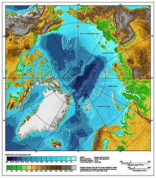
The Arctic consists of land, internal waters, territorial seas, exclusive economic zones (EEZs) and international waters above the Arctic Circle. All land, internal waters, territorial seas and EEZs in the Arctic are under the jurisdiction of one of the eight Arctic coastal states: Canada, Denmark, Finland, Iceland, Norway, Russia, Sweden and the United States. International law regulates this area as with other portions of Earth.

<span class="mw-page-title-main">Timor Sea Treaty</span> 2002 geopolitical agreement

Formally known as the Timor Sea Treaty between the Government of East Timor and the Government of Australia was signed between Australia and East Timor in Dili, East Timor on 20 May 2002, the day East Timor attained its independence from United Nations rule, for joint petroleum exploration of the Timor Sea by the two countries. The signatories of the treaty were then Australian prime minister John Howard and his East Timorese counterpart at that time Mari Alkatiri.

<span class="mw-page-title-main">Australia–Indonesia border</span> International maritime border between Australia and Indonesia

The Australia–Indonesia border is a maritime boundary running west from the two countries' tripoint maritime boundary with Papua New Guinea in the western entrance to the Torres Straits, through the Arafura Sea and Timor Sea, and terminating in the Indian Ocean. The boundary is, however, broken by the Timor Gap, where Australian and East Timorese territorial waters meet and where the two countries have overlapping claims to the seabed.

<span class="mw-page-title-main">Treaty on Certain Maritime Arrangements in the Timor Sea</span>

Officially called the Treaty between Australia and the Democratic Republic of Timor-Leste on Certain Maritime Arrangements in the Timor Sea (CMATS), the treaty provides for the equal distribution of revenue derived from the disputed Greater Sunrise oil and gas field between Australia and East Timor. The field is located in the Timor Gap where Australia and East Timor have overlapping claims over the continental shelf or seabed. Prior to the treaty, East Timor would only have received about 18% of the revenue from the field.

<span class="mw-page-title-main">Australia–East Timor relations</span> Bilateral relations

Bilateral relations exist between Australia and East Timor. Both countries are near neighbors with close political and trade ties. East Timor, the youngest and one of the poorest countries in Asia, lies about 610 kilometres northwest of the Australian city of Darwin and Australia has played a prominent role in the young republic's history.

<span class="mw-page-title-main">Arctic cooperation and politics</span> Between the eight Arctic nations

Arctic cooperation and politics are partially coordinated via the Arctic Council, composed of the eight Arctic nations: the United States, Canada, Iceland, Norway, Sweden, Finland, Russia, and Denmark with Greenland and the Faroe Islands. The dominant governmental power in Arctic policy resides within the executive offices, legislative bodies, and implementing agencies of the eight Arctic nations, and to a lesser extent other nations, such as United Kingdom, Germany, European Union and China. NGOs and academia play a large part in Arctic policy. Also important are intergovernmental bodies such as the United Nations and NATO.

<span class="mw-page-title-main">Maritime boundary</span> Conceptual division of the Earths water surface areas using physiographic or geopolitical criteria

A maritime boundary is a conceptual division of the Earth's water surface areas using physiographic or geopolitical criteria. As such, it usually bounds areas of exclusive national rights over mineral and biological resources, encompassing maritime features, limits and zones. Generally, a maritime boundary is delineated at a particular distance from a jurisdiction's coastline. Although in some countries the term maritime boundary represents borders of a maritime nation that are recognized by the United Nations Convention on the Law of the Sea, maritime borders usually serve to identify the edge of international waters.

<span class="mw-page-title-main">East China Sea EEZ disputes</span>

There are disputes between China, Japan, Taiwan and South Korea over the extent of their respective exclusive economic zones (EEZs) in the East China Sea.

<i>Philippines v. China</i> 2016 international arbitration case

Philippines v. China, also known as the South China Sea Arbitration, was an arbitration case brought by the Republic of the Philippines against the People's Republic of China (PRC) under Annex VII of the United Nations Convention on the Law of the Sea concerning certain issues in the South China Sea, including the nine-dash line introduced by the Republic of China (Taiwan) since as early as 1947. A tribunal of arbitrators appointed the Permanent Court of Arbitration (PCA) as the registry for the proceedings.

<span class="mw-page-title-main">Exclusive economic zone of Australia</span>

Australia's exclusive economic zone (EEZ) was declared on 1 August 1994 and extends from 12 to 200 nautical miles from the coastline of Australia and its external territories, except where a maritime delimitation agreement exists with another state. To the 12 nautical-mile boundary is Australia's territorial waters. Australia has the third-largest exclusive economic zone, behind the United States and France but ahead of Russia, with the total area of 8,148,250 square kilometres (3,146,060 sq mi), which exceeds its land territory.

The borders of Indonesia include land and maritime borders with Malaysia, Papua New Guinea, and Timor Leste, as well as shared maritime boundaries with Australia, India, Palau, Philippines, Singapore, Thailand, and Vietnam.

The Barents Sea is a secluded part of the Arctic Ocean divided between Norway and Russia. The politics in the Barents Sea is of paramount importance for the 2 countries relationship, showing both maritime conflict and maritime cooperation.

References

  1. "Treaty between Australia and the Republic of Indonesia on the Zone of Cooperation in an Area between the Indonesian Province of East Timor and Northern Australia". Australasian Legal Information Institute - Australian Treaty Series 1991. 1991. Retrieved 20 October 2008.
  2. 1 2 3 4 5 6 7 8 9 10 11 12 13 14 15 16 17 18 Martin, W. and Pickersgill, D (1991). "The Timor Gap Treaty". Harvard International Law Journal. 32 (2): 566–581.{{cite journal}}: CS1 maint: multiple names: authors list (link)
  3. 1 2 3 4 5 6 7 8 9 Australia. Parliament. Senate. Foreign Affairs, Defence and Trade References Committee. (1999). East Timor : final report of the Senate Foreign Affairs, Defence and Trade References Committee. The Committee. ISBN   0-642-71103-8. OCLC   755697210.
  4. 1 2 3 4 5 6 "Latest developments | East Timor (Portugal v. Australia) | International Court of Justice". www.icj-cij.org. Retrieved 2 June 2020.
  5. 1 2 3 4 "Treaties". www.info.dfat.gov.au. Retrieved 2 June 2020.
  6. 1 2 3 Kaye, Stuart (1999). "The Timor Gap Treaty". Natural Resources & Environment. 14 (2): 92–144. ISSN   0882-3812. JSTOR   40924391.
  7. 1 2 CHALK, PETER (2001). "Australia and Indonesia: Rebuilding Relations After East Timor". Contemporary Southeast Asia. 23 (2): 233–253. doi:10.1355/CS23-2C. ISSN   0129-797X. JSTOR   25798544.
  8. 1 2 HOADLEY, STEPHEN (1976). "East Timor: Civil War — Causes and Consequences". Southeast Asian Affairs. 1976: 411–419. doi:10.1355/SEAA76ZD. ISSN   0377-5437. JSTOR   27908293.
  9. 1 2 3 Suter, Keith (1993). "Timor Gap treaty". Marine Policy. 17 (4): 294–302. doi:10.1016/0308-597x(93)90084-g. ISSN   0308-597X.
  10. Chomsky, Noam (3 November 2011). "Noam Chomsky: can revolutionary pacificism deliver peace?". The Conversation. Archived from the original on 29 January 2013. Retrieved 2 June 2020.
  11. 1 2 3 4 5 6 7 8 9 10 11 12 13 14 "Kaye, Stuart --- "The Timor Gap Treaty: Creative Solutions and International Conflict" [1994] SydLawRw 5; (1994) 16(1) Sydney Law Review 72". classic.austlii.edu.au. Retrieved 2 June 2020.
  12. 1 2 3 4 "East Timor and me: A response to Noam Chomsky". 12 October 2015. Archived from the original on 12 October 2015. Retrieved 2 June 2020.
  13. UN. United Nations convention on the Law of the Sea. OCLC   1032571596.
  14. Dixon, David (2017). "Exploiting the Timor Sea: Oil, Gas, Water, and Blood". SSRN Working Paper Series. doi:10.2139/ssrn.2995430. ISSN   1556-5068. S2CID   146776956.
  15. Schofield, Clive H., 1969- (2007). Minding the Gap : the Australia-East Timor Treaty on Certain Maritime Arrangements in the Timor Sea (CMATS). OCLC   774850222.{{cite book}}: CS1 maint: multiple names: authors list (link)
  16. 1 2 3 4 5 6 7 "ATNS - Agreements, Treaties and Negotiated Settlements project". www.atns.net.au. Retrieved 2 June 2020.
  17. 1 2 "East Timor (Portugal v. Australia)". International Court of Justice. 30 June 1995. Retrieved 26 November 2014.
  18. Smith, Anthony (1999). "EAST TIMOR: opting for independence". New Zealand International Review. 24 (6): 6–9. JSTOR   45234876.
  19. Hendrapati, Marcel (30 April 2015). "Maritime Expansion and Delimitation After the Timor Gap Treaty". Indonesia Law Review. 5 (1): 69. doi: 10.15742/ilrev.v5n1.138 . ISSN   2088-8430.
  20. Cotton, James (2003). "From 'Timor Gap' to 'Timor Sea'". AQ: Australian Quarterly. 75 (2): 27–40. doi:10.2307/20638165. ISSN   1443-3605. JSTOR   20638165.
  21. 1 2 "Time to draw the line between Australia and Timor Leste". Eureka Street. Retrieved 2 June 2020.
  22. Office, Australian Taxation. "Timor Sea Treaty - Joint Petroleum Development Area instructions 2019". www.ato.gov.au. Retrieved 2 June 2020.
  23. 1 2 3 Schleich, Anne-Marie (September 2018). "The Historic 2018 Maritime Boundary Treaty between Timor-Leste and Australia" (PDF). ISPSW Strategy Series: Focus on Defense and International Security. 573: 2–7.

Further reading