Geodesy is the science of measuring and representing the geometry, gravity, and spatial orientation of the Earth in temporally varying 3D. It is called planetary geodesy when studying other astronomical bodies, such as planets or circumplanetary systems.

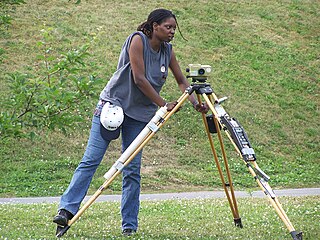
Surveying or land surveying is the technique, profession, art, and science of determining the terrestrial two-dimensional or three-dimensional positions of points and the distances and angles between them. These points are usually on the surface of the Earth, and they are often used to establish maps and boundaries for ownership, locations, such as the designed positions of structural components for construction or the surface location of subsurface features, or other purposes required by government or civil law, such as property sales.

In navigation, bearing or azimuth is the horizontal angle between the direction of an object and north or another object. The angle value can be specified in various angular units, such as degrees, mils, or grad. More specifically:

A theodolite is a precision optical instrument for measuring angles between designated visible points in the horizontal and vertical planes. The traditional use has been for land surveying, but it is also used extensively for building and infrastructure construction, and some specialized applications such as meteorology and rocket launching.

A total station or total station theodolite is an electronic/optical instrument used for surveying and building construction. It is an electronic transit theodolite integrated with electronic distance measurement (EDM) to measure both vertical and horizontal angles and the slope distance from the instrument to a particular point, and an on-board computer to collect data and perform triangulation calculations.

A geodetic datum or geodetic system is a global datum reference or reference frame for precisely representing the position of locations on Earth or other planetary bodies by means of geodetic coordinates. Datums are crucial to any technology or technique based on spatial location, including geodesy, navigation, surveying, geographic information systems, remote sensing, and cartography. A horizontal datum is used to measure a location across the Earth's surface, in latitude and longitude or another coordinate system; a vertical datum is used to measure the elevation or depth relative to a standard origin, such as mean sea level (MSL). Since the rise of the global positioning system (GPS), the ellipsoid and datum WGS 84 it uses has supplanted most others in many applications. The WGS 84 is intended for global use, unlike most earlier datums.
Levelling or leveling is a branch of surveying, the object of which is to establish or verify or measure the height of specified points relative to a datum. It is widely used in geodesy and cartography to measure vertical position with respect to a vertical datum, and in construction to measure height differences of construction artifacts.

A geodetic control network is a network, often of triangles, that are measured precisely by techniques of control surveying, such as terrestrial surveying or satellite geodesy. It is also known as a geodetic network, reference network, control point network, or simply control network.
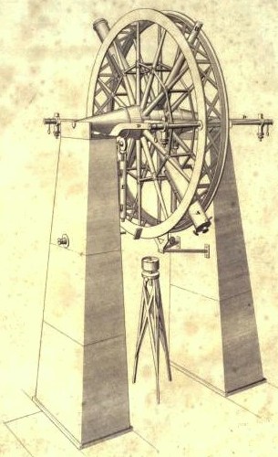
The meridian circle is an instrument for timing of the passage of stars across the local meridian, an event known as a culmination, while at the same time measuring their angular distance from the nadir. These are special purpose telescopes mounted so as to allow pointing only in the meridian, the great circle through the north point of the horizon, the north celestial pole, the zenith, the south point of the horizon, the south celestial pole, and the nadir. Meridian telescopes rely on the rotation of the sky to bring objects into their field of view and are mounted on a fixed, horizontal, east–west axis.

Tacheometry is a system of rapid surveying, by which the horizontal and vertical positions of points on the Earth's surface relative to one another are determined using a tacheometer without using a chain or tape, or a separate levelling instrument. Instead of the pole normally employed to mark a point, a staff similar to a level staff is used. This is marked with heights from the base or foot, and is graduated according to the form of tacheometer in use.
Base end stations were used by the United States Army Coast Artillery Corps as part of fire control systems for locating the positions of attacking ships and controlling the firing of seacoast guns, mortars, or mines to defend against them. A British equivalent was the position finding cell.

A fire control tower is a structure located near the coastline, used to detect and locate enemy vessels offshore, direct fire upon them from coastal batteries, or adjust the aim of guns by spotting shell splashes. Fire control towers came into general use in coastal defence systems in the late 19th century, as rapid development significantly increased the range of both naval guns and coastal artillery. This made fire control more complex. These towers were used in a number of countries' coastal defence systems through 1945, much later in a few cases such as Sweden. The Atlantic Wall in German-occupied Europe during World War II included fire control towers.
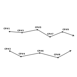
Position resection and intersection are methods for determining an unknown geographic position by measuring angles with respect to known positions. In resection, the one point with unknown coordinates is occupied and sightings are taken to the known points; in intersection, the two points with known coordinates are occupied and sightings are taken to the unknown point.
Construction surveying or building surveying is to provide dimensional control for all stages of construction work, including the stake out of reference points and markers that will guide the construction of new structures such as roads, rail, or buildings. These markers are usually staked out according to a suitable coordinate system selected for the project.
A plotting board was a mechanical device used by the U.S. Army Coast Artillery Corps as part of their fire control system to track the observed course of a target, project its future position, and derive the uncorrected data on azimuth and range needed to direct the fire of the guns of a battery to hit that target. Plotting boards of this sort were first employed by the Coast Artillery around 1905, and were the primary means of calculating firing data until WW2. Towards the end of WW2 these boards were largely replaced by radar and electro-mechanical gun data computers, and were relegated to a back-up role.
While compass surveying, the magnetic needle is sometimes disturbed from its normal position under the influence of external attractive forces. Such a disturbing influence is called as local attraction. The external forces are produced by sources of local attraction which may be current carrying wire or metal objects. The term is also used to denote amount of deviation of the needle from its normal position. It mostly causes errors in observations while surveying and thus suitable methods are employed to negate these errors.
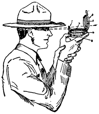
A prismatic compass is a navigation and surveying instrument which is extensively used to find out the bearing of the traversing and included angles between them, waypoints and direction. Compass surveying is a type of surveying in which the directions of surveying lines are determined with a magnetic compass, and the length of the surveying lines are measured with a tape or chain or laser range finder. The compass is generally used to run a traverse line. The compass calculates bearings of lines with respect to magnetic needle. The included angles can then be calculated using suitable formulas in case of clockwise and anti-clockwise traverse respectively. For each survey line in the traverse, surveyors take two bearings that is fore bearing and back bearing which should exactly differ by 180° if local attraction is negligible. The name Prismatic compass is given to it because it essentially consists of a prism which is used for taking observations more accurately.
In surveying, free stationing is a method of determining a location of one unknown point in relation to known points. There is a zero point of reference called a total station. The instrument can be freely positioned so that all survey points are at a suitable sight from the instrument. When setting up the total station on a known point, it is often not possible to see all survey points of interest. When performing a resection with the total station, bearings and distances are measured to at least two known points of a control network. With use of a handheld computer, recorded data can be related to local polar coordinates, defined by the horizontal circle of the total station. By a geometric transformation, these polar coordinates are transformed to the coordinate system of the control network. Error can be distributed by least squares adjustment. Upon completion of observations and calculations, a coordinate is produced, and the position and orientation of the total station in relation to where the control network is established.

In surveying, triangulation is the process of determining the location of a point by measuring only angles to it from known points at either end of a fixed baseline by using trigonometry, rather than measuring distances to the point directly as in trilateration. The point can then be fixed as the third point of a triangle with one known side and two known angles.

Geopositioning is the process of determining or estimating the geographic position of an object.