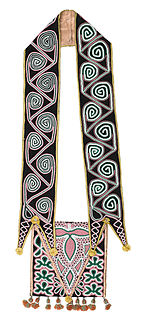
The Muscogee, also known as the Mvskoke, Muscogee Creek, and the Muscogee Creek Confederacy, are a group of related indigenous peoples of the Southeastern Woodlands in the United States of America. Their original homelands are in what now comprises southern Tennessee, much of Alabama, western Georgia and parts of northern Florida.
The Trail of Tears was part of the Indian removal, a series of forced displacements and ethnic cleansing of approximately 60,000 Native Americans of the Five Civilized Tribes between 1830 and 1850 by the United States government. Tribal members "moved gradually, with complete migration occurring over a period of nearly a decade." Members of the so-called Five Civilized Tribes—the Cherokee, Muscogee (Creek), Seminole, Chickasaw, and Choctaw nations were forcibly removed from their ancestral homelands in the Southeastern United States to areas to the west of the Mississippi River that had been designated Indian Territory. The forced relocations were carried out by government authorities after the passage of the Indian Removal Act in 1830. The Cherokee removal in 1838 was brought on by the discovery of gold near Dahlonega, Georgia in 1828, resulting in the Georgia Gold Rush.
Carroll County is a county located in the northwestern part of the State of Georgia. As of the 2010 census, its population was approximately 110,527. Its county seat is the city of Carrollton. Carroll County is included in the Atlanta-Sandy Springs-Roswell, GA Metropolitan Statistical Area. It is located just east of the boundary with Alabama.

Whitesburg is a town in Carroll County, Georgia, United States. The population was 588 at the 2010 census.

The Creek War (1813–1814), also known as the Red Stick War and the Creek Civil War, was a regional war between opposing Creek factions, European empires and the United States, taking place largely in today's Alabama and along the Gulf Coast. The major conflicts of the war took place between state militia units and the "Red Stick" Creeks. The United States government formed an alliance with the Choctaw Nation and Cherokee Nation, along with the remaining Creeks to put down the rebellion.
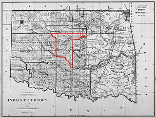
The Unassigned Lands in Oklahoma were in the center of the lands ceded to the United States by the Creek (Muskogee) and Seminole Indians following the Civil War and on which no other tribes had been settled. By 1883 it was bounded by the Cherokee Outlet on the north, several relocated Indian reservations on the east, the Chickasaw lands on the south, and the Cheyenne-Arapaho reserve on the west. The area amounted to 1,887,796.47 acres.

Ocmulgee Mounds National Historical Park in Macon, Georgia, United States preserves traces of over ten millennia of culture from the Native Americans in the Southeastern Woodlands. Its chief remains are major earthworks built before 1000 CE by the South Appalachian Mississippian culture These include the Great Temple and other ceremonial mounds, a burial mound, and defensive trenches. They represented highly skilled engineering techniques and soil knowledge, and the organization of many laborers. The site has evidence of "17,000 years of continuous human habitation." The 3,336-acre (13.50 km2) park is located on the east bank of the Ocmulgee River. Macon, Georgia developed around the site after the United States built Fort Benjamin Hawkins nearby in 1806 to support trading with Native Americans.
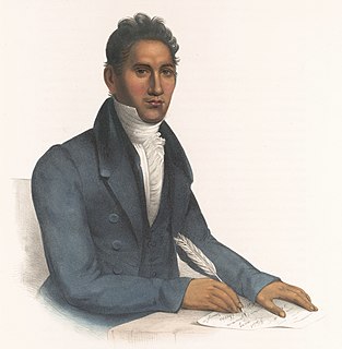
John Ridge, born Skah-tle-loh-skee, was from a prominent family of the Cherokee Nation, then located in present-day Georgia. He went to Cornwall, Connecticut, to study at the Foreign Mission School. He met Sarah Bird Northup, of a New England Yankee family, and they married in 1824. Soon after their return to New Echota in 1825, Ridge was chosen for the Cherokee National Council and became a leader in the tribe.

Opothleyahola, also spelled Opothle Yohola, Opothleyoholo, Hu-pui-hilth Yahola, Hopoeitheyohola, and Hopere Yahvlv was a Muscogee Creek Indian chief, noted as a brilliant orator. He was a Speaker of the Upper Creek Council and supported traditional culture.

George McIntosh Troup was an American politician from the U.S. state of Georgia. He served in the Georgia General Assembly, U.S. House of Representatives, and U.S. Senate before becoming the 32nd Governor of Georgia for two terms and then returning to the U.S. Senate. A believer in expansionist Manifest Destiny policies and a supporter of native Indian removal, Troup was born to planters and supported slavery throughout his career. Later in his life, he was known as "the Hercules of states' rights."

Menawa, first called Hothlepoya, was a Muscogee (Creek) chief and military leader. He was of mixed race, with a Creek mother and a fur trader father of mostly Scots ancestry. As the Creek had a matrilineal system of descent and leadership, his status came from his mother's clan.

William McIntosh, was also commonly known as Tustunnuggee Hutke, was one of the most prominent chiefs of the Creek Nation between the turn of the nineteenth century and his execution in 1825. He was a chief of Coweta town and commander of a mounted police force. He became a large-scale planter, built and managed a successful inn, and operated a commercial ferry business. Early American historians attributed McIntosh's achievements and influence to his mixed race Scots/European ancestry. Since the late 20th century, historians have argued much of McIntosh's political influence stemmed more from his Creek upbringing and cultural standing, particularly his mother's prominent Wind Clan in the Creek matrilineal system, and to other aspects of Creek culture.

The Treaty of Cusseta was a treaty between the government of the United States and the Creek Nation signed March 24, 1832. The treaty ceded all Creek claims east of the Mississippi River to the United States.

The Treaty of Fort Stanwix was a treaty finalized on October 22, 1784, between the United States and Native Americans from the six nations of the Iroquois League. It was signed at Fort Stanwix, in present-day Rome, New York, and was the first of several treaties between Native Americans and the United States after the American victory in the Revolutionary War.

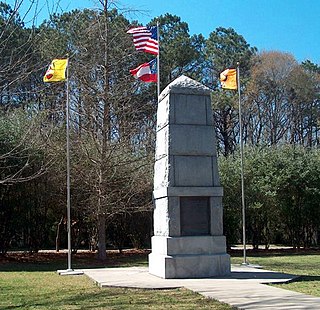
McIntosh Reserve is an outdoor recreation area along the Chattahoochee River located in Carroll County, Georgia. The 527-acre (2.13 km2) park is operated by the Carroll County Recreation Department and supports outdoor activities including camping, hiking, fishing, and others. The park is open year-round, closing only on Thanksgiving, Christmas, and New Year's Day. McIntosh Reserve is named for William McIntosh, Jr., a prominent Creek Indian leader
The Cherokee have participated in over forty treaties in the past three hundred years.
On the eve of the American Civil War in 1861, a significant number of Indigenous peoples of the Americas had been relocated from the Southeastern United States to Indian Territory, west of the Mississippi. The inhabitants of the eastern part of the Indian Territory, the Five Civilized Tribes, were suzerain nations with established tribal governments, well established cultures, and legal systems that allowed for slavery. Before European Contact these tribes were generally matriarchial societies, with agriculture being the primary economic pursuit. The bulk of the tribes lived in towns with planned streets, residential and public areas. The people were ruled by complex hereditary chiefdoms of varying size and complexity with high levels of military organization.
The Treaty of Indian Springs, also known as the First Treaty of Indian Springs and the Treaty with the Creeks, is a treaty concluded between the Muscogee and the United States on January 8, 1821 at what is now Indian Springs State Park.
The Treaty of Indian Springs, also known as the Second Treaty of Indian Springs and the Treaty with the Creeks, is a treaty concluded between the Muscogee and the United States on February 12, 1825 at what is now the Indian Springs Hotel Museum.
Acorn Creek is a stream in Carroll County in the U.S. state of Georgia, at an elevation of 666 feet (203 m) above mean sea level. It is a tributary to the Chattahoochee River with a discharge rate of 2.74 cfs.
