The Global 200 is the list of ecoregions identified by the World Wide Fund for Nature (WWF), the global conservation organization, as priorities for conservation. According to WWF, an ecoregion is defined as a "relatively large unit of land or water containing a characteristic set of natural communities that share a large majority of their species dynamics, and environmental conditions". For example, based on their levels of endemism, Madagascar gets multiple listings, ancient Lake Baikal gets one, and the North American Great Lakes get none.

Tropical and subtropical moist broadleaf forests (TSMF), also known as tropical moist forest, is a subtropical and tropical forest habitat type defined by the World Wide Fund for Nature.

The East Deccan dry evergreen forests is an ecoregion of southeastern India. The ecoregion includes the coastal region behind the Coromandel Coast on the Bay of Bengal, between the Eastern Ghats and the sea. It covers eastern Tamil Nadu, part of Puducherry and south eastern Andhra Pradesh.

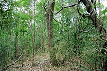
The South Western Ghats moist deciduous forests is an ecoregion in the Western Ghats of southern India with tropical and subtropical moist broadleaf forests. This biome covers the Nilgiri Hills between elevation of 250 and 1,000 m in Kerala, Karnataka and Tamil Nadu states.
Laurel forest, also called laurisilva or laurissilva, is a type of subtropical forest found in areas with high humidity and relatively stable, mild temperatures. The forest is characterized by broadleaf tree species with evergreen, glossy and elongated leaves, known as "laurophyll" or "lauroid". Plants from the laurel family (Lauraceae) may or may not be present, depending on the location.
The term Malabar rainforests refers to one or more distinct ecoregions recognized by biogeographers:
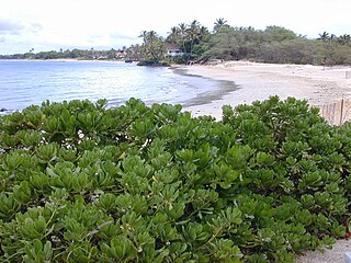
- the Malabar Coast moist forests formerly occupied the coastal zone to the 250 metre elevation
- the South Western Ghats moist deciduous forests grow at intermediate elevations
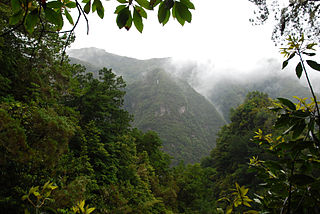
- the South Western Ghats montane rain forests cover the areas above 1000 metres elevation

The Eastern Highlands moist deciduous forests, presently known as East Deccan moist deciduous forests, is a tropical and subtropical moist broadleaf forests ecoregion in east-central India. The ecoregion covers an area of 341,100 square kilometers (131,700 sq mi), extending across portions of Andhra Pradesh, Chhattisgarh, Jharkhand, Madhya Pradesh, Maharashtra, Odisha, and Telangana states.
The Lower Gangetic Plains moist deciduous forests is a tropical and subtropical moist broadleaf forests ecoregion of Bangladesh and India. The ecoregion covers an area of 254,100 square kilometres (98,100 sq mi), comprising most of Bangladesh and the Indian states of West Bengal, Bihar and Tripura, and extending into adjacent states of Odisha, Uttar Pradesh and a tiny part of Assam, as well as adjacent western Myanmar.

The Narmada Valley dry deciduous forests are a tropical dry forest ecoregion of central India. The ecoregion lies mostly in Madhya Pradesh state, but extends into portions of Chhattisgarh, Maharashtra, Karnataka and Uttar Pradesh states.

The Northern Indochina subtropical forests are a subtropical moist broadleaf forest ecoregion of northern Indochina, covering portions of Vietnam, Laos, Thailand, Myanmar, and China's Yunnan Province.
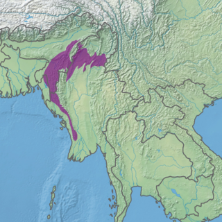
The Mizoram–Manipur–Kachin rain forests is a subtropical moist broadleaf forest ecoregion which occupies the lower hillsides of the mountainous border region joining India, Bangladesh, and Burma (Myanmar) and China's Yunnan Province. The ecoregion covers an area of 135,600 square kilometres (52,400 sq mi). Located where the biotas of the Indian Subcontinent and Indochina meet, and in the transition between subtropical and tropical regions of Asia, the Mizoram–Manipur–Kachin rain forests are home to great biodiversity. The WWF rates the ecoregion as "Globally Outstanding" in biological distinctiveness.
The ecology of the Himalayas varies with climate, rainfall, altitude, and soils. The climate ranges from tropical at the base of the mountains to permanent ice and snow at the highest elevations. The amount of yearly rainfall increases from west to east along the southern front of the range. This diversity of climate, altitude, rainfall and soil conditions supports a variety of distinct plant and animal species, such as the Nepal gray langur

Biogeographic classification of India is the division of India according to biogeographic characteristics. Biogeography is the study of the distribution of species (biology), organisms, and ecosystems in geographic space and through geological time. India has a rich heritage of natural diversity. India ranks fourth in Asia and tenth in the world amongst the top 17 mega-diverse countries in the world. India harbours nearly 11% of the world's floral diversity comprising over 17500 documented flowering plants, 6200 endemic species, 7500 medicinal plants and 246 globally threatened species in only 2.4% of world's land area. India is also home to four biodiversity hotspots—Andaman & Nicobar Islands, Eastern Himalaya, Indo-Burma region, and the Western Ghats. Hence the importance of biogeographical study of India's natural heritage.
Tropical vegetation is any vegetation in tropical latitudes. Plant life that occurs in climates that are warm year-round is in general more biologically diverse that in other latitudes. Some tropical areas may receive abundant rain the whole year round, but others have long dry seasons which last several months and may vary in length and intensity with geographic location. These seasonal droughts have great impact on the vegetation, such as in the Madagascar spiny forests.

Seasonal tropical forest, also known as moist deciduous, semi-evergreen seasonal, tropical mixed or monsoon forest, typically contains a range of tree species: only some of which drop some or all of their leaves during the dry season. This tropical forest is classified under the Walter system as (i) tropical climate with high overall rainfall and (ii) having a very distinct wet season with dry season. These forests represent a range of habitats influenced by monsoon (Am) or tropical wet savannah (Aw) climates. Drier forests in the Aw climate zone are typically deciduous and placed in the Tropical dry forest biome: with further transitional zones (ecotones) of savannah woodland then tropical and subtropical grasslands, savannas, and shrublands.

The Luang Prabang montane rain forests ecoregion covers elevations over 800 meters in the Luang Prabang mountains that straddle the border between northern Thailand and north-central Laos, and the highlands that stretch eastward across north-central Laos. While much of the forest cover has been degraded, there are still large areas of relatively untouched forest.
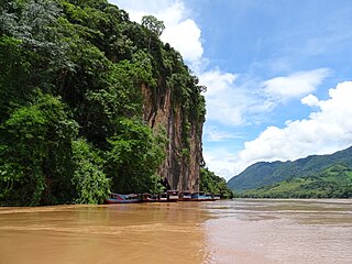
The Northern Thailand–Laos moist deciduous forests ecoregion follows the upper course of the Nan River in northern Thailand and the Mekong River in Laos. This area has the highest proportion of tree cover in Thailand, with many forests dominated by Teak. The river valleys have been under pressure from human use: agriculture, teak plantations, and hunting have reduce plant and animal presence.