Turukkaeans

Last updated

The Turukkaeans were a Bronze and Iron Age people of Zagros Mountains. Their endonym has sometimes been reconstructed as Tukri.

Contents

Their race is disputed by historians.Some historians say they are Turkic [1] [2] [3] [4] [5] [6] [7] [8] [9] [10] [11] , and another group says that they are İranian. [12]

History

Middle Bronze

Turukku was regarded by the Old Assyrian Empire as a constant threat, during the reign of Shamshi-Adad I (1813-1782 BCE) and his son and successor Ishme-Dagan (1781-1750 BCE). The Turukkaeans were allied to the Land of Ahazum, and they gathered at the town of Ikkallum to face the army of Ishme-Dagan, as Shamshi-Adad wrote in a letter to his other son Yasmah-Adad.

The Turukkaeans were reported to have sacked the city of Mardaman, apparently under Hurrian rule, around the year 1769/68 BCE. [13] Babylon's defeat of Turukku was celebrated in the 37th year of Hammurabi's reign (c. 1773 BCE).

A significant early reference to them is an inscription by the Babylonian king Hammurabi, (r. circa 1792 – c. 1752 BCE) that mentions a kingdom named Tukriš(UET I l. 46, iii–iv, 1–4), alongside Gutium, Subartu and another name that is usually reconstructed as Elam. Other texts from the same period refer to the kingdom as Tukru.

Iron Age

By the early part of the 1st millennium BCE, names such as Turukkum, Turukku and ti-ru-ki-i are being used for the same region. In a broader sense, names such as Turukkaean been used in a generic sense to mean "mountain people" or "highlanders".

A map of Mesopotamia and south-western Iran during the 2nd Millennium BCE. The Tukri are generally believed to have been located immediately north of Lullubi (top centre of the map) during this period. Elam1.png
A map of Mesopotamia and south-western Iran during the 2nd Millennium BCE. The Tukri are generally believed to have been located immediately north of Lullubi (top centre of the map) during this period.

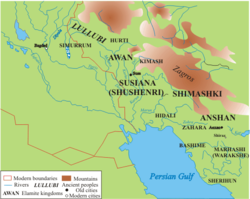
Tukru or Turukkum was said to have spanned the north-east edge of Mesopotamia and an adjoining part of the Zagros Mountains. In particular, they were associated with the Lake Urmia basin and the valleys of the north-east Zagros. They were therefore located north of ancient Lullubi, and at least one Neo-Assyrian (9th to 7th centuries BCE) text refers to the whole area and its peoples as "Lullubi-Turukki" (VAT 8006).

Their Race

The race of Turukkaeans is disputed. The most common guesses are:

Hurrians

Some scholars believe they may have been Hurrian-speaking or subject to a Hurrian elite.According to the Jørgen læssøe, they are an Hurrian people [14] But we should not forget that Turukkaeans sacked Madraman, a hurrian city.

Iranian

Even though there is not any sources that says Turukkaeans are Iranian, some of them think they are. [12] The fact that they live near Iran strengthens this claim.

Turkic People

There's a lot of sources that says Turukkaeans are a Turkic [5] [3] [4] Tribe.According to German orientalist Fritz Hommel,the Turukkaeans are Turk. [2] Famous historian Sjur Papazian also says Turukkaeans were a Turkic tribe [1] .A Turkish historian O. Ünal says that Turukkaeans are Turkic in his book which he researched Hurrian Language. [9] Azerbaijani historian Yusif Yusifov also approves that.

French historians also agreed with Turkicness of Turukkaeans. [15]


See also

Footnotes

  1. 1 2 Turkic Peoples-Name etymology "...Turukkaeans (Turukkum, Turukku) were an ancient near eastern people in the northern parts of Mesopotamia..."
  2. 1 2 Fritz Hommel- Gestichichte Babyloniens und Assyriens,2016.
  3. 1 2 Азярбайжан Милли Елмляр Академийасы Ялйазмалар Институту вя «Елм вя тящсил» няшриййаты - Филолоэийа мясяляляри No. 8. Бакы – 2013. ISSN 2224-9257. p.6-13.
  4. 1 2 Казымов Г.Ш. Мцасир Азярбайъан дили. Морфолоэийа. Бакы, «Нурлан», 2010. p.4-6
  5. 1 2 Türk Dünyası Araştırmaları Vakfı, Türk dünyası araştırmaları, 2004, page 35: Kuzey Mezopotamya'da Yafes soyundan kalan küçük bir kısım Türk kavmi, yani Gutium veya Turukkular ise zamanla ya millî ...
  6. Meydan,Sinan.Türklerin Saklı Tarihi.İnkılap Yayınevi.
  7. A. Akif Poroy,Ön-Türkler.Bilge Karınca Yayınları
  8. BEYER, D.- D. Charpin, 1990, “Le sceau de Zaziya, roi des Turukkéens,” MARI 6, Paris p. 625-628.
  9. 1 2 ÜNAL, O . "‘Sözde Karca’ Kelimelerin Kökeni ve Türkçedeki Hurri-Urartuca Leksikal Alıntılar Üzerine". Türkbilig (2017 ):p.25-68
  10. Q. Qeybullayev – Azerbaycan türklerinin teşekkül tarixinden, Bakı, 1994
  11. F. Celilov – Azer xalqı, II nüşri Bakı, 2006
  12. 1 2 Turukkular Kimdir? "...Imaginative historians who defend the Sun-Language Theory introduce the Turukku as the Turkish Kingdom due to the similarity of names, but only they believe this. When you do research from any foreign source, you will see that the Turukku are a Hurrian tribe speaking an Indo-European language."
  13. Pfälzner, Peter, (2018). "Keilschrifttafeln von Bassetki lüften Geheimnis um Königsstadt Mardaman". uni-tuebingen.de. University of Tubingen.{{cite web}}: CS1 maint: multiple names: authors list (link) CS1 maint: numeric names: authors list (link)
  14. Læssøe, Jørgen (2014-10-24). People of Ancient Assyria: Their Inscriptions and Correspondence. Routledge. ISBN   9781317602613.
  15. revue des etudes sud-est europeennes>>>"The name 'Turk' in Mari Texts" "B. The Landsberger's thesis is confirmed by the fact that in 1800 B.C. name of Turuk (Türk) was mentioned in several times in the tablets discovered in the Mari excavation."

Bibliography

Related Research Articles

<span class="mw-page-title-main">Yamhad</span> Semitic kingdom in Syria

Yamhad (Yamḫad) was an ancient Semitic-speaking kingdom centered on Ḥalab (Aleppo) in Syria. The kingdom emerged at the end of the 19th century BC and was ruled by the Yamhad dynasty, who counted on both military and diplomacy to expand their realm. From the beginning of its establishment, the kingdom withstood the aggressions of its neighbors Mari, Qatna and the Old Assyrian Empire, and was turned into the most powerful Syrian kingdom of its era through the actions of its king Yarim-Lim I. By the middle of the 18th century BC, most of Syria minus the south came under the authority of Yamhad, either as a direct possession or through vassalage, and for nearly a century and a half, Yamhad dominated northern, northwestern and eastern Syria, and had influence over small kingdoms in Mesopotamia at the borders of Elam. The kingdom was eventually destroyed by the Hittites, then annexed by Mitanni in the 16th century BC.

<span class="mw-page-title-main">Zagros Mountains</span> Mountain range in Western Asia

The Zagros Mountains are a long mountain range in Iran, northern Iraq, and southeastern Turkey. The mountain range has a total length of 1,600 km (990 mi). The Zagros range begins in northwestern Iran and roughly follows Iran's western border while covering much of southeastern Turkey and northeastern Iraq. From this border region, the range continues southeast under also the waters of the Persian Gulf. It spans the southern parts of the Armenian highlands, the whole length of the western and southwestern Iranian plateau, ending at the Strait of Hormuz. The highest point is Mount Dena, at 4,409 metres (14,465 ft).

<span class="mw-page-title-main">Iraqi Kurdistan</span> Kurdish-inhabited and self-governing region in northern Iraq

Iraqi Kurdistan or Southern Kurdistan refers to the Kurdish-populated part of northern Iraq. It is considered one of the four parts of "Kurdistan" in West Asia, which also includes parts of southeastern Turkey, northern Syria, and northwestern Iran. Much of the geographical and cultural region of Iraqi Kurdistan is part of the Kurdistan Region (KRI), an autonomous region recognized by the Constitution of Iraq. As with the rest of Kurdistan, and unlike most of the rest of Iraq, the region is inland and mountainous.

<span class="mw-page-title-main">Teshub</span> Hurrian weather god and king of the gods

Teshub was the Hurrian weather god, as well as the head of the Hurrian pantheon. The etymology of his name is uncertain, though it is agreed it can be classified as linguistically Hurrian. Both phonetic and logographic writings are attested. As a deity associated with the weather, Teshub could be portrayed both as destructive and protective. Individual weather phenomena, including winds, lightning, thunder and rain, could be described as his weapons. He was also believed to enable the growth of vegetation and create rivers and springs. His high position in Hurrian religion reflected the widespread importance of weather gods in northern Mesopotamia and nearby areas, where in contrast with the south agriculture relied primarily on rainfall rather than irrigation. It was believed that his authority extended to both mortal and other gods, both on earth and in heaven. However, the sea and the underworld were not under his control. Depictions of Teshub are rare, though it is agreed he was typically portrayed as an armed, bearded figure, sometimes holding a bundle of lightning. One such example is known from Yazılıkaya. In some cases, he was depicted driving in a chariot drawn by two sacred bulls.

<span class="mw-page-title-main">Lullubi</span> 2300–675 BC Ancient Near Eastern group of tribes

Lullubi,Lulubi, more commonly known as Lullu, were a group of Bronze Age tribes during the 3rd millennium BC, from a region known as Lulubum, now the Sharazor plain of the Zagros Mountains of modern-day Sulaymaniyah Governorate, Iraq. Lullubi was neighbour and sometimes ally with the Hurrian Simurrum kingdom. Frayne (1990) identified their city Lulubuna or Luluban with the region's modern town of Halabja.

<span class="mw-page-title-main">Little Zab</span> River in Iran, Iraq

The Little Zab or Lower Zab is a river that originates in Iran and joins the Tigris just south of Al Zab in the Kurdistan region of Iraq. The Little Zab is approximately 400 kilometres (250 mi) long and drains an area of about 22,000 square kilometres (8,500 sq mi). The river is fed by rainfall and snowmelt, resulting in a peak discharge in the spring and low water in the summer and early fall. Two dams built on the Little Zab regulate the river flow, providing water for irrigation and generating hydroelectricity. The Zagros Mountains have been populated since at least the Lower Palaeolithic, but the earliest archaeological site in the Little Zab basin, Barda Balka, dates to the Middle Palaeolithic. Human occupation of the Little Zab basin has been attested for every period since then.

<span class="mw-page-title-main">History of Mesopotamia</span>

The history of Mesopotamia ranges from the earliest human occupation in the Paleolithic period up to Late antiquity. This history is pieced together from evidence retrieved from archaeological excavations and, after the introduction of writing in the late 4th millennium BC, an increasing amount of historical sources. While in the Paleolithic and early Neolithic periods only parts of Upper Mesopotamia were occupied, the southern alluvium was settled during the late Neolithic period. Mesopotamia has been home to many of the oldest major civilizations, entering history from the Early Bronze Age, for which reason it is often called a cradle of civilization.

<span class="mw-page-title-main">Ekallatum</span>

Ekallatum (Akkadian: 𒌷𒂍𒃲𒈨𒌍, URUE2.GAL.MEŠ, Ekallātum, "the Palaces") was an ancient Amorite city-state and kingdom in upper Mesopotamia.

The Old Assyrian period was the second stage of Assyrian history, covering the history of the city of Assur from its rise as an independent city-state under Puzur-Ashur I c. 2025 BC to the foundation of a larger Assyrian territorial state after the accession of Ashur-uballit I c. 1363 BC, which marks the beginning of the succeeding Middle Assyrian period. The Old Assyrian period is marked by the earliest known evidence of the development of a distinct Assyrian culture, separate from that of southern Mesopotamia and was a geopolitically turbulent time when Assur several times fell under the control or suzerainty of foreign kingdoms and empires. The period is also marked with the emergence of a distinct Assyrian dialect of the Akkadian language, a native Assyrian calendar and Assur for a time becoming a prominent site for international trade.

Tell al-Rimah is an archaeological settlement mound, in Nineveh Province (Iraq) roughly 80 kilometres (50 mi) west of Mosul and ancient Nineveh in the Sinjar region. It lies 15 kilometers south of the site of Tal Afar. Its ancient name in the 2nd Millennium BC is thought have been Karana though the name of Qattara has also been suggested. In any case Karana and Qattara were very close together and thought to be part of a small kingdom. It has also been suggested that the site's name in the 1st Millennium BC was Zamaḫâ. It is near the circular walled similar archaeological sites of Tell Hadheil, a large Early Dynastic site with Old Babylonian and Neo-Assyrian occupation, and Tell Huweish. Tell Hamira, known earlier as Tell Abu Hamira, is 16 kilometers to the east and has also been suggested as the site of Karana. Currently, archaology leans toward Qattara as the ancient name of Tell Al-Rimah.

<span class="mw-page-title-main">Gutian language</span> Extinct unclassified language of the Near East

Gutian is an extinct unclassified language that was spoken by the Gutian people, who briefly ruled over Sumer as the Gutian dynasty in the 22nd century BCE. The Gutians lived in the territory between the Zagros Mountains and the Tigris. Nothing is known about the language except its existence and a list of names of Gutian rulers in the Sumerian King List, which may reflect elements of the language.

Tell Shemshara is an archaeological site located along the Little Zab in Sulaymaniyah Governorate, northeastern Iraq. The site was inundated by Lake Dukan until recently.

<span class="mw-page-title-main">Akkad (city)</span> Ancient Mesopotamian city

Akkad was the capital of the Akkadian Empire, which was the dominant political force in Mesopotamia during a period of about 150 years in the last third of the 3rd millennium BC.

<span class="mw-page-title-main">Timeline of ancient Assyria</span>

The timeline of ancient Assyria can be broken down into three main eras: the Old Assyrian period, Middle Assyrian Empire, and Neo-Assyrian Empire. Modern scholars typically also recognize an Early period preceding the Old Assyrian period and a post-imperial period succeeding the Neo-Assyrian period.

Rapiqum, ra-bi-qa-wiKI, was a city of the ancient Near East. The city was located in the north of Mesopotamia, probably on the eastern bank of the Euphrates River, in modern Iraq. It is firmly attested from early in the 2nd Millennium BC until early in the 1st Millennium BC.

Išḫi-Addu or Ishi-Addu was king of Qatna in the first half of the 18th century BC. He is known for his correspondences with Shamshi-Adad I of Assyria who was his closest ally. Qatna was at its height during Išḫi-Addu's reign, which was, however, plagued with revolts in the southern parts of the kingdom and with constant war with Yamhad, Qatna's northern neighbour.

Mardaman was a northern Mesopotamian city that existed between ca.2200 and 1200 BC. It was uncovered in 2018 after translation of 92 cuneiform tablets. The tablets were discovered in summer 2017, near the Kurdish village of Bassetki, by a team of archaeologists. The team hailed from Tübingen's Institute for Ancient Near Eastern Studies, and were led by Prof. Dr. Peter Pfälzner of the University of Tübingen. The city-god of Mardaman was the Hurrian goddess Shuwala. After the time of Assyrian occupation it is uncertain if this continued. It is thought that later in the 1st millennium BC a temple of Gula was at Mardaman.

<span class="mw-page-title-main">Simurrum</span> City state of the Mesopotamian area from around 2000 BCE to 1500 BCE

Simurrum was an important city state of the Mesopotamian area from around 2000 BCE to 1500 BCE, during the period of the Akkadian Empire down to Ur III. The Simurrum Kingdom disappears from records after the Old Babylonian period. It is thought that in Old Babylonian times its name was Zabban, a notable cult center of Adad. It was neighbor and sometimes ally with the Lullubi kingdom.

Kurd Qaburstan, is an ancient Near East archaeological site in the Erbil Governorate, in the Kurdistan Region of Iraq, 22 kilometers southwest of Erbil. It is considered one of the most important archaeological sites in the region. The site is strategically located between the Upper and Lower Zab rivers. The modern village of Yedi Kizlar is adjacent to and covers a portion of the southeastern lower town. The site is primarily a single-period site dating to the early 2nd millennium BC, the Middle Bronze Age. There is also a compact Late Bronze Age occupation on the high mound. Kurd Qaburstan has been proposed as the location of the ancient city of Qabra. The site is located near Tell Halawa, Tell Aliawa, Tell Baqrta, and Qasr Shemamok (Kilizi), other prominent sites on the Erbil plain.

Šimānum was an ancient Near East city-state whose location is not yet known. Its areal location is known to be in the northernmost part of Mesopotamia or the southernmost part of Anatolia, in the vicinity of the Tigris river, north of the Upper Zab river, and near the confluence of the Tigris and eastern Habur river. It is well documented during the time of the Ur III Empire in the late 3rd Millennium BC. It has been proposed that Šimānum was known, under different names, in other periods. If those proposals are correct the site was active from the Akkadian Empire period though the Old Babylonian period. Šimānum is also the name of an Old Babylonian month.