
Sheboygan County is a county in the U.S. state of Wisconsin. It is named after the Sheboygan River. As of the 2020 census, the population was 118,034. Its county seat is Sheboygan. The county was created in 1836 and organized in 1846. At the time, it was located in the Wisconsin Territory. Sheboygan County comprises the Sheboygan, WI Metropolitan Statistical Area. Part of the Holyland region is located in northwestern Sheboygan County.

Ozaukee County is a county in the U.S. state of Wisconsin. As of the 2020 census, the population was 91,503. Its county seat is Port Washington. Ozaukee County is included in the Milwaukee–Waukesha–West Allis, WI Metropolitan Statistical Area.
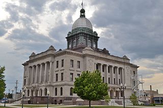
Manitowoc County is a county in the U.S. state of Wisconsin. As of the 2020 census, the population was 81,359. Its county seat is Manitowoc. The county was created in 1836 prior to Wisconsin's statehood and organized in 1848. Manitowoc County comprises the Manitowoc, WI Micropolitan Statistical Area.
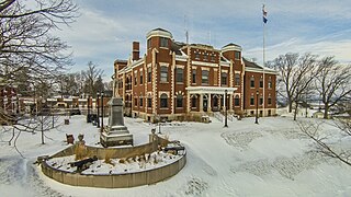
Kewaunee County is a county located in the U.S. state of Wisconsin. As of the 2020 census, the population was 20,563. Its county seat is Kewaunee. The county was created in 1852 and organized in 1859. Its Menominee name is Kewāneh, an archaic name for a species of duck. Kewaunee County is part of the Green Bay, WI Metropolitan Statistical Area as well as the Green Bay-Shawano, WI Combined Statistical Area.
Carlton is a town in Kewaunee County, Wisconsin, United States. The population was 1,014 at the 2010 census. Carlton is probably named for James Carlton, an early settler in the area.
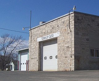
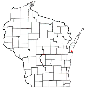
Cato is a town in Manitowoc County, Wisconsin, United States. The population was 1,616 at the 2000 census. A Manitowoc County park is located in the town; it is called "Cato Falls" for a waterfall on the Manitowoc River.

Francis Creek is a village in Manitowoc County, Wisconsin, United States. The population was 659 at the 2020 census. The village is located within the town of Kossuth.

Manitowoc Rapids is a town in Manitowoc County, Wisconsin, United States. The population was 2,520 at the 2000 census.

Maple Grove is a town in Manitowoc County, Wisconsin, United States. The population was 852 at the 2000 census.

Meeme is a town in Manitowoc County, Wisconsin, United States. The population was 1,538 at the 2000 census. Its Menominee name is Omīnīw which means "pigeon". The Menominee sold this land to the United States in the 1831 Treaty of Washington.

Newton is a town in Manitowoc County, Wisconsin, United States. The population was 2,241 at the 2000 census.

Wagner is a town in Marinette County, Wisconsin, United States. The population was 722 at the 2000 census. The unincorporated communities of Goll, McAllister, Packard, and Wagner are located in the town.
Cedar Grove is a village in Sheboygan County, Wisconsin, United States, within the Town of Holland. The population was 2,101 at the 2020 census. It is included in the Sheboygan, Wisconsin Metropolitan Statistical Area.

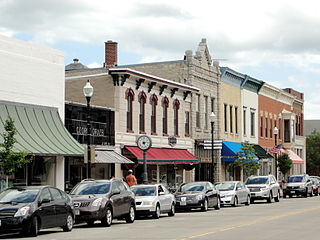
Manitowoc is a city in and the county seat of Manitowoc County, Wisconsin, United States. The city is located on Lake Michigan at the mouth of the Manitowoc River. According to the 2020 census, Manitowoc had a population of 34,626, with over 50,000 residents in the surrounding communities.
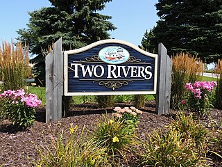
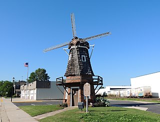
Two Rivers is a city in Manitowoc County, Wisconsin, United States. The population was 11,271 at the 2020 census. It is the birthplace of the ice cream sundae. The city's advertising slogan is "Catch our friendly waves" as it is located along Lake Michigan.

Belgium is a village in Ozaukee County, Wisconsin, United States. Located along Interstate 43, the village is one of the northernmost communities in the Milwaukee metropolitan area. The population was 2,245 at the 2010 census.
Sturgeon Bay is a city in and the county seat of Door County, Wisconsin, United States. The population was 9,646 at the 2020 census. Located at the bay of Sturgeon Bay for which it is named, it is the most-populous city on the Door Peninsula, a popular Upper Midwest vacation destination.
Newton is an unincorporated community located in the town of Newton, Manitowoc County, Wisconsin, United States. Newton is located along Interstate 43 near Exit 144, 5.5 miles (8.9 km) east-northeast of Cleveland. Newton has a post office with ZIP code 53063.

Home was a two-masted schooner which sank in Lake Michigan off Centerville in Manitowoc County, Wisconsin, United States, in 1858. In 2010 the shipwreck site was added to the National Register of Historic Places.

The Wisconsin Shipwreck Coast National Marine Sanctuary is one of 15 United States National Marine Sanctuaries administered by the National Oceanic and Atmospheric Administration (NOAA), an agency of the United States Department of Commerce; NOAA co-manages the sanctuary jointly with the State of Wisconsin. It is located in Lake Michigan along the coast of Wisconsin. It was created in 2021 to protect shipwrecks considered nationally important archaeological resources.

