U3 is a line on the Berlin U-Bahn created in its current version on 7 May 2018.
The routing is largely the same as the previous U2 until 1993, but it runs from Krumme Lanke to Wittenbergplatz. The route was renumbered to U1 from 1993 to 2004. It was extended one station further east to Nollendorfplatz to enable trains to be reversed and to allow one-stop transfer to the U4 in 2003. On 7 May 2018, the U3 was extended to run with the U1 all the way to Warschauer Straße.
Changing routes and designations
The line to Krumme Lanke station has changed several times in the course of its existence. Initially, line A connected Krumme Lanke in the southwest of Berlin with Pankow in the north and was marked in red on the network maps. From 1957 two lines served the southwestern section of the line: the red route AII to Pankow as before, and a green route BII to Warschauer Brücke. After the construction of the Berlin Wall in 1961, the small profile network was completely redesigned in 1966. The route to Dahlem received the line designation 2, running initially to Gleisdreieck via Bülowstraße, and from 1972 only to Wittenbergplatz. Line 3—with a dark green colour code—was assigned to the Uhlandstraße–Wittenbergplatz stub track. This changed again in 1993 as the line was marked green again and received the line number U1, which ran to Warschauer Straße. The designation U3 for the route to Uhlandstraße, however, disappeared, as this was now served by line U15, also running to Warschauer Straße. Finally, the line was redesignated from the network timetable change in December 2004 to the turquoise U3. Since 2005, the line has also operated as a late night service. From 4 to 7 March 2013, the trains were designated again as U1 between Krumme Lanke and Warschauer Straße due to construction work on the section between Uhlandstraße and Kurfürstendamm. Unlike in analogous cases (U12), no corresponding line designation (U13) was introduced here. From 2004 to 2018, line U3 was limited to the Krumme Lanke–Nollendorfplatz section.
The U3 currently starts at Warschauer Straße. From there it runs together with the U1 on its line to Wittenbergplatz. Under Tauentzienstraße it turns in a tight right-angle curve to the southwest and follows the streets of Nürnberger Straße and Spichernstraße to Spichernstraße station (interchange station to the U9) at the intersection with Bundesallee. It then follows Hohenzollerndamm to Fehrbelliner Platz, which provides interchange with the U7, and continues south under Barstrasse. Below street level, the U3 crosses the Fennsee (lake) in Volkspark Wilmersdorf (park) on a two-level bridge. Beyond the A 100 and after passing under the Ringbahn at Heidelberger Platz it follows the streets of Aßmannshauser Straße, Rüdesheimer Straße and Schorlemerallee and leaves the tunnel immediately before Podbielskiallee station. From there, the U3 continues in a cutting next to Archivstrasse and later Brümmerstrasse. Passing behind Freie Universität (Thielplatz), it turns due west. The last section runs south of the streets of Saargemünder Straße and Argentinische Allee. The U3 terminates at Krumme Lanke station, named after a nearby lake, at the intersection of Fischerhüttenstraße and Argentinische Allee.
History
In the summer of 1907, the Hochbahngesellschaft ("Elevated Railway Company") of the new town of Wilmersdorf proposed the construction of an underground railway through the area. A route was envisaged running to Nürnberger Platz and, if Wilmersdorf would pay for it, on to Rastatter Platz, now Breitenbachplatz. Since Wilmersdorf had poor transport links, this suggestion was readily accepted. The commission for the development of the lands of Dahlem Manor, which were further south and were still largely undeveloped, was very interested in a rail connection. It wanted the proposed line to continue from Breitenbachplatz to Thielplatz.
Now, however, a big problem arose. The proposed line would run partly through Charlottenburg, but the municipality of Charlottenburg saw Wilmersdorf as a major competitor when it came to attracting wealthy taxpayers. Long negotiations were conducted until the following agreement was finalised in the summer of 1910: in addition to the line already planned, another one would be built in Charlottenburg under Kurfürstendamm with the provisional terminus at Uhlandstraße.
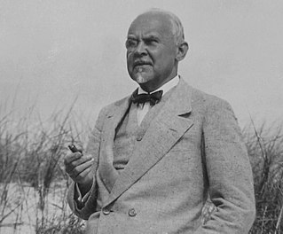
According to one source, the then Prussian Minister of Public Works, Paul von Breitenbach, is said to have directed the city of Charlottenburg to allow the construction of the Wilmersdorf U-Bahn. As a result Rastatter Platz station and the square it was named after before the opening of the U-Bahn was renamed Breitenbachplatz by the grateful city of Wilmersdorf.[2]
Construction work began in the summer of 1910. The following stations had to be built or converted:
Wittenbergplatz (conversion)
Nürnberger Platz (now closed)
Hohenzollernplatz
Fehrbelliner Platz
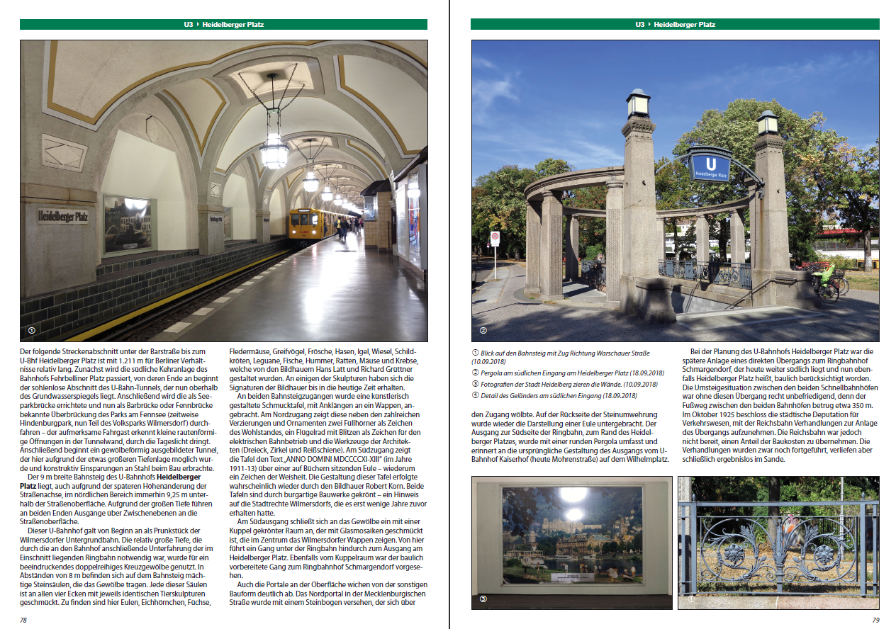
Heidelberger Platz
Rüdesheimer Platz
Breitenbachplatz (originally planned as Rastatter Platz)
Podbielskiallee
Dahlem-Dorf
Thielplatz (temporary terminus, then having a small waiting room)
as well as on the Charlottenburg line:
Uhlandstraße
The previously double-track Wittenbergplatz station, which was only equipped with two side platforms, had to be completely rebuilt. A junction station was built with five platform faces, a sixth was prepared and a vestibule was built. The cities of Wilmersdorf and Charlottenburg presented various proposals; Finally, however, the chief of police recommended building it according to the plans of Alfred Grenander, the in-house architect of the Elevated Railway Company.
The stations in the Wilmersdorf area were elaborately designed, because the city was prosperous and wanted to show it. Today this can still be seen at the Hohenzollernplatz, Fehrbelliner Platz, Heidelberger Platz, Rüdesheimer Platz and Breitenbachplatz stations.
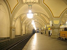
Heidelberger Platz represented an additional special feature, because the line of the Ringbahn is very low at this point in a cutting, so the U-Bahn had to be tunnelled even deeper. Therefore, beyond the underpass of the Ringbahn, there was the possibility to use the large space between the top of the carriages and ground level and design the station even more magnificently than the others on this line, that is like a cathedral with a hall vault and hanging illuminated candelabras (it is sometimes compared with the magnificent underground stations of the Moscow Metro from the 1930s). In addition, outside the station, the tunnels in both directions were built with a tunnel-like profile as far as the depth below the surface permitted (the purpose of this subway tunnel construction, which was rare in Berlin at the time, was to save large amounts of steel girders, which were required everywhere with cut and cover construction).[3]
Beyond Breitenbachplatz, the line reached the Dahlem Manor lands. Due to the sparse development, the route could be built in an open cutting. Since the platforms could not be further decorated, the architects focused primarily on the individual design of the entrance buildings.
The additional route to Uhlandstraße, which Charlottenburg had won in the "negotiation poker", only received one more station. The route branches off at Wittenbergplatz, runs parallel to the tracks of today's U1 as far as Breitscheidplatz and continues under Kurfürstendamm to Uhlandstraße station. An extension to Halensee was planned. At the intersection with the newly built large profile route G (now: line U9), another station was added in 1961 with the Kurfürstendamm station, which received side platforms.
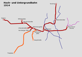
The lines to Thielplatz and to Uhlandstrasse both opened on 12 October 1913. Together they were about ten kilometres long. This was the last U-Bahn construction in Berlin before the First World War, which began on 1 August 1914. No more U-Bahn lines were completed until ten years later.
A gift U-Bahn line
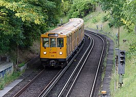
Train already signposted for its return journey (consisting of A3L, A3L still with decorative strips, A3) passes the Krumme Lanke depot, 1987Old control panel of the signal box at Breitenbachplatz station in the Berlin U-Bahn Museum
The southern end of the Wilmersdorf-Dahlemer U-Bahn did not hold good prospects for an extension. The Dahlem line had been unprofitable since it opened and only a single car was operated from Breitenbachplatz to Thielplatz as a so-called "solo car".
Greater Berlin, which was united in 1920, demanded that the Prussian government or the Dahlem Commission (Dahlemkommission) take over the line (including the operating cost grants) and took legal action in the Reichsgericht (supreme court) to this end. However, in the years that followed, the financial situation of the line improved considerably with increasing development. The Prussian government was finally able to hand over the line to the city free of charge and debt-free on 1 January 1928.[4]
At the same time, the Sommerfeld group, which owned large areas in the southwest of Berlin that were still undeveloped, offered free land and the assumption of construction costs for an extension of the line to Krumme Lanke. In fact, the city was gifted three kilometres of U-Bahn.
The line would have the following stations, which are all located in a cutting:
Krumme Lanke (terminus with a four-track workshop and storage hall in front)
This section went into service on 22 December 1929. The Onkel Toms Hütte ("Uncle Tom's Cabin") station and housing estate were named after a nearby restaurant of the same name. The Krumme Lanke station received a New Objectivity style entrance building, which was one of Alfred Grenander's late works. The station forecourt was named after him on 6 June 2009.[5] Since the building had become dilapidated, it had to be demolished in 1988. A good replica was built in 1989. The terminus of today's U3 line is named after a nearby lake.
A workshop consisting of a carriage shed with a workshop building was built at Krumme Lanke station. However, due to a lack of capacity, the workshop was closed in 1968 and necessary repairs were outsourced to the Grunewald workshop. In the years that followed, the carriage shed was primarily used as a storage facility, where minor repairs such as changing lamps were only occasionally carried out. Years of not investing in the maintenance of the carriage shed finally led to its closure due to dilapidation in 2014. The hall is heritage-listed.
Modifications
During the construction of line G, now U9, an interchange station was to be built at the intersection of the two lines. However, since there was no station at the Spichernstraße/ Bundesallee intersection on the U3—then line 2—the Spichernstraße station was built. The nearby Nürnberger Platz station was closed and completely gutted on 1July 1959. The area of the former central platform was converted into a double-track siding, which is accessed from Spichernstraße. However, the distance of 1106metres between the Wittenbergplatz and Spichernstraße stations was considered unacceptable for the City West area, so the new Augsburger Straße station was built. It was considered necessary to minimise the impact on the existing structure at both new small-profile stations, so both were built with side platforms. They were opened on 2June 1959 (Spichernstraße) and 8May 1961 (Augsburger Straße). The architecture is strongly based on Grenander's model. The buildings were designed in a functional style based on designs by the then subway architect Bruno Grimmek. Augsburger Straße station was decorated with red-brown tiles and Spichernstraße with light blue tiles.
In 1981, a second entrance building was built at Thielplatz station, which also houses a substation. This shortened the way to the campus of the Free University of Berlin.
Extension to Warschauer Straße
On 7 May 2018. the U3 was "extended" eastwards on the existing line used by the U1 to the terminus at Warschauer Straße. In other words, the route that existed until 2004 as the then U1 line was restored. This facilitates the movement of students and others from there to the Free University and extended the denser service from Nollendorfplatz eastwards.[6] The extension of the line was facilitated by the new four-car class IK18 sets becoming available in April 2018.[7]
Opening dates
12 October 1913: Wittenbergplatz – Thielplatz
24 October 1926: Wittenbergplatz – Nollendorfplatz (underground)
22 December 1929: Thielplatz – Krumme Lanke
2 June 1959: Spichernstraße station opened; simultaneous closure of Nürnberger Platz station
8 May 1961: Augsburger Straße station
Extension
In the south, there are plans to extend the U3 towards the Berlin Mexikoplatz station, running via Lindenthaler Allee. Even though this would only take 700 meters of new tracks, the budgetary constraints of the Berlin Senate hinders completion.
Frequency
Train run every 5 minutes on weekdays, every 10 minutes on weekends and since 2006 every 15-minute early mornings on Saturday and Sunday. On the other nights the "N3" bus service operates.
Until 1993 U3 referred to the section of line between Wittenbergplatz and Uhlandstraße, it was formerly numbered BII (until 1957), BIV (from 1957 to 1966) and Line 3 (from 1966 to 1984), before being renamed U3. In 1993, this section was renumbered to U15 and became a branch of the U1.
With the change of line numbers in December 2004, there were some confusion as the planned final phase of the U3 line from Theodor-Heuss-Platz via Westkreuz, Adenauerplatz, Kurfürstendamm, Wittenbergplatz, Lutzowplatz, Potsdamer Platz, and Leipziger Straße to Alexanderplatz, and from there on to Weißensee and Karow-Ost, which would overlap with the present course of the U3 and the unbuilt U10, as well as the provisional future rolling stock which was intended to be driverless Alstom Metropolis trains for the U3. However, these plans were scrapped.
↑ Formerly "Berliner Rathaus" in the 1995 plan.[8]
Related Research Articles
The Berlin U-Bahn is a rapid transit system in Berlin, the capital and largest city of Germany, and a major part of the city's public transport system. Together with the S-Bahn, a network of suburban train lines, and a tram network that operates mostly in the eastern parts of the city, it serves as the main means of transport in the capital.
U1 is a line on the Berlin U-Bahn, which is 8.8 kilometres (5.5 mi) long and has 13 stations. Its traditional line designation was BII. It runs east–west and its eastern terminus is Warschauer Straße S-Bahn station where it connects to the Schlesische Bahn. From there it runs through Kreuzberg via Gleisdreieck and Wittenbergplatz on to the Kurfürstendamm.
U2 is a line of the Berlin U-Bahn. The U2 line starts at Pankow S-Bahn station, runs through the eastern city centre (Alexanderplatz) to Potsdamer Platz, the western city centre and finally to the Ruhleben terminal station.
The U4 is a line of the Berlin U-Bahn in Germany that is the shortest in Berlin's U-Bahn system, with a length of 2.86 kilometres (1.78 mi). Opened in 1910, the U4 serves five stations, all of which are step-free: it is also the only subway line in Berlin to have never been extended and the only one to have no night service on weekends.
The U7 is a rail line on the Berlin U-Bahn. It runs completely underground for a length of 31.8 kilometres (19.8 mi) through 40 stations and connects Spandau, via Neukölln, to Gropiusstadt and Rudow. The U7 was originally the south-eastern branch of the Nord-Süd-Bahn (U6) that ran between the branching point at Belle-Alliance-Straße (Mehringdamm) and Grenzallee; however, in the 1960s, this stretch was separated from the rest of the line and extended at each end to form a new line.
U9 is a line on the Berlin U-Bahn. The line was opened on 28 August 1961 as Line G.
Alfred Frederik Elias Grenander was a Swedish architect, who became one of the most prominent engineers during the first building period of the Berlin U-Bahn network in the early twentieth century.
Uhlandstraße is the western terminus station of line U1 of the Berlin U-Bahn. It is located on Kurfürstendamm in the central Charlottenburg quarter of Berlin, among a mix of chain and high end shopping facilities.
Zehlendorf is a locality within the borough of Steglitz-Zehlendorf in Berlin. Before Berlin's 2001 administrative reform Zehlendorf was a borough in its own right, consisting of the locality of Zehlendorf as well as Wannsee, Nikolassee and Dahlem. Zehlendorf contains some of the most remarked upon natural settings in Berlin, including parts of the Grunewald forest and the Schlachtensee, Krumme Lanke and Waldsee lakes. Additionally, it has large affluent residential neighborhoods, some with cobblestone streets and buildings that are over 100 years old.
Ernst-Reuter-Platz is a Berlin U-Bahn station on line U2, located in the Charlottenburg district.
Deutsche Oper is a station of the Berlin U-Bahn on line U2, located in the Charlottenburg district. It is named after the Deutsche Oper Berlin.
Augsburger Straße is a Berlin U-Bahn station on the U3 line. It is located in Charlottenburg under Nürnberger Straße where Augsburger Straße crosses it. Station and street are named after the city of Augsburg.
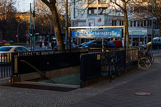
Spichernstraße is a Berlin U-Bahn station located on the U3 and the U9 lines, located in Wilmersdorf neighbourhood. The U3 portion opened on 2 June 1959, replacing the nearby Nürnberger Platz station, which was closed and dismantled. The U9 portion, which lies deeper underground, opened on 28 August 1961 as the southern terminus of the new line, then called G. The eponymous street is named after Spicheren in Lorraine, France, site of the 1870 Battle of Spicheren.
Hohenzollernplatz is a Berlin U-Bahn station located in the Wilmersdorf district on the U3 line.
Breitenbachplatz is a Berlin U-Bahn station located in the Dahlem district on the U3.
The U12 is an inactive Berlin U-Bahn line. It existed between 1993 and June 2003, as a peak-time and night line between Ruhleben and Warschauer Straße stations. The route remains available for temporary use when it is not possible to run a full U1 or U2 service for reasons such as maintenance.
Bus transport is the oldest public transport service in Berlin, the capital city of Germany, having been introduced in 1846. Since 1929, services have been operated by the Berlin Transport Company, although during the Cold War-era division of the city they operated in West Berlin only. In East Berlin the public transport agency split off from the BVG and rebranded as BVB, operating the busses in the soviet sector of Berlin.
Nürnberger Platz was a Berlin U-Bahn station on what is now the U3, located under the square of the same name in Wilmersdorf on the border with Charlottenburg. The station opened on 12 October 1913 and was permanently closed on 1 June 1959.
The Berlin U-Bahn originated in 1880 with Werner Siemens' idea to build an urban railway in Berlin. During the nine years after the German Empire was founded, the city's population grew by over one-third and traffic problems increased. In 1896, Siemens & Halske began to construct the first stretch of overhead railway. On 1 April 1897, the company began construction of an electric underground railway. The Berliner Verkehrs Aktiengesellschaft (BVG) was formed in 1928, and took over further construction and operation of the network. In 1938, the company was renamed Berlin Transport Company; the original acronym, however, remained. Since 1994, the BVG has been a public company.
The tracks of the Berlin subway are lines operated in the line traffic, operating distances, which serve only internal purposes, turn-off and turning plants and plants in the operating farms.
References
↑ "Berlin Subway • Trackmap"(PDF). Gleisplanweb.de (in German and English). Kranenburg: Christian Stade. 11 December 2022. Archived from the original(PDF) on 7 April 2023. Retrieved 11 June 2023.
↑ Wedemeyer, Alfred. "Die Verlängerung der Berliner Schnellbahn Thielplatz – Krumme Lanke". Deutsche Bauzeitung (in German). 64 (Jahrgang 1930, Beilage Stadt und Siedlung, No. 4): 25 ff.
↑ Senatsverwaltung für Verkehr und Betriebe (July 1995). Verkehrsplanung für Berlin (in German) (1ed.). Berlin: H. Heenemann GmbH. p.Ö43. Archived from the original on 15 April 2016. Retrieved 9 June 2023.
This page is based on this Wikipedia article Text is available under the CC BY-SA 4.0 license; additional terms may apply. Images, videos and audio are available under their respective licenses.


