Related Research Articles

In aviation, instrument flight rules (IFR) is one of two sets of regulations governing all aspects of civil aviation aircraft operations; the other is visual flight rules (VFR).
In aviation, visual flight rules (VFR) are a set of regulations under which a pilot operates an aircraft in weather conditions generally clear enough to allow the pilot to see where the aircraft is going. Specifically, the weather must be better than basic VFR weather minima, i.e., in visual meteorological conditions (VMC), as specified in the rules of the relevant aviation authority. The pilot must be able to operate the aircraft with visual reference to the ground, and by visually avoiding obstructions and other aircraft.

Air traffic control (ATC) is a service provided by ground-based air traffic controllers who direct aircraft on the ground and through a given section of controlled airspace, and can provide advisory services to aircraft in non-controlled airspace. The primary purpose of ATC worldwide is to prevent collisions, organize and expedite the flow of air traffic, and provide information and other support for pilots.

In aviation and aviation meteorology, a flight level (FL) is an aircraft's altitude at standard air pressure, expressed in hundreds of feet. The air pressure is computed assuming an International Standard Atmosphere pressure of 1013.25 hPa (29.92 inHg) at sea level, and therefore is not necessarily the same as the aircraft's actual altitude, either above sea level or above ground level.

Controlled airspace is airspace of defined dimensions within which air traffic control (ATC) services are provided. The level of control varies with different classes of airspace. Controlled airspace usually imposes higher weather minimums than are applicable in uncontrolled airspace. It is the opposite of uncontrolled airspace.

Airspace is the portion of the atmosphere controlled by a country above its territory, including its territorial waters or, more generally, any specific three-dimensional portion of the atmosphere. It is not the same as aerospace, which is the general term for Earth's atmosphere and the outer space in its vicinity.

In aviation, visual meteorological conditions (VMC) is an aviation flight category in which visual flight rules (VFR) flight is permitted—that is, conditions in which pilots have sufficient visibility to fly the aircraft maintaining visual separation from terrain and other aircraft. They are the opposite of instrument meteorological conditions (IMC). The boundary criteria between IMC and VMC are known as the VMC minima and are defined by: visibility, cloud ceilings, and cloud clearances.

A traffic collision avoidance system, also known as a traffic alert and collision avoidance system, is an aircraft collision avoidance system designed to reduce the incidence of mid-air collision (MAC) between aircraft. It monitors the airspace around an aircraft for other aircraft equipped with a corresponding active transponder, independent of air traffic control, and warns pilots of the presence of other transponder-equipped aircraft which may present a threat of MAC. It is a type of airborne collision avoidance system mandated by the International Civil Aviation Organization to be fitted to all aircraft with a maximum take-off mass (MTOM) of over 5,700 kg (12,600 lb) or authorized to carry more than 19 passengers. CFR 14, Ch I, part 135 requires that TCAS I be installed for aircraft with 10-30 passengers and TCAS II for aircraft with more than 30 passengers. ACAS/TCAS is based on secondary surveillance radar (SSR) transponder signals, but operates independently of ground-based equipment to provide advice to the pilot on potentially conflicting aircraft.
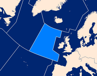
Shanwick is the air traffic control (ATC) name given to the area of international airspace which lies above the northeast part of the Atlantic Ocean.

In the United States, airways or air routes are defined by the Federal Aviation Administration (FAA) in two ways:
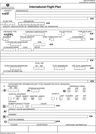
Flight plans are documents filed by a pilot or flight dispatcher with the local Air Navigation Service Provider prior to departure which indicate the plane's planned route or flight path. Flight plan format is specified in ICAO Doc 4444. They generally include basic information such as departure and arrival points, estimated time en route, alternate airports in case of bad weather, type of flight, the pilot's information, number of people on board, and information about the aircraft itself. In most countries, flight plans are required for flights under IFR, but may be optional for flying VFR unless crossing international borders. Flight plans are highly recommended, especially when flying over inhospitable areas such as water, as they provide a way of alerting rescuers if the flight is overdue. In the United States and Canada, when an aircraft is crossing the Air Defense Identification Zone (ADIZ), either an IFR or a special type of VFR flight plan called a DVFR flight plan must be filed. For IFR flights, flight plans are used by air traffic control to initiate tracking and routing services. For VFR flights, their only purpose is to provide needed information should search and rescue operations be required, or for use by air traffic control when flying in a "Special Flight Rules Area."
The world's navigable airspace is divided into three-dimensional segments, each of which is assigned to a specific class. Most nations adhere to the classification specified by the International Civil Aviation Organization (ICAO) and described below, though they might use only some of the classes defined below, and significantly alter the exact rules and requirements. Similarly, individual nations may also designate special use airspace (SUA) with further rules for reasons of national security or safety.

Canadian airspace is the region of airspace above the surface of the Earth within which Canada has jurisdiction. It falls within a region roughly defined as either the Canadian land mass, the Canadian Arctic or the Canadian archipelago, and areas of the high seas. Airspace is managed by Transport Canada and detailed information regarding exact dimensions and classification is available in the Designated Airspace Handbook which is published every fifty-six days by Nav Canada.
Special visual flight rules are a set of aviation regulations under which a pilot may operate an aircraft. It is a special case of operating under visual flight rules (VFR).
A flight information service (FIS) is a form of air traffic service which is available to any aircraft within a flight information region (FIR), as agreed internationally by ICAO.
The United States airspace system's classification scheme is intended to maximize pilot flexibility within acceptable levels of risk appropriate to the type of operation and traffic density within that class of airspace – in particular to provide separation and active control in areas of dense or high-speed flight operations.

The Grand Canyon mid-air collision occurred in the western United States on Saturday, June 30, 1956, when a United Airlines Douglas DC-7 struck a Trans World Airlines Lockheed L-1049 Super Constellation over Grand Canyon National Park, Arizona. All 128 on board both airplanes perished, making it the first commercial airline incident to exceed one hundred fatalities. The airplanes had departed Los Angeles International Airport minutes apart for Chicago and Kansas City, respectively. The collision took place in uncontrolled airspace, where it was the pilots' responsibility to maintain separation. This highlighted the antiquated state of air traffic control, which became the focus of major aviation reforms.
The National Airspace System (NAS) is the airspace, navigation facilities and airports of the United States along with their associated information, services, rules, regulations, policies, procedures, personnel and equipment. It includes components shared jointly with the military. It is one of the most complex aviation systems in the world, and services air travel in the United States and over large portions of the world's oceans.

Aviation call signs are communication call signs assigned as unique identifiers to aircraft.
Karachi Area Control Centre is one of two Area Control Centers in Pakistan operated by the Pakistan Civil Aviation Authority and is based in Terminal 1 at Jinnah International Airport in Karachi. Karachi ACC air traffic controllers provide en route and terminal control services to aircraft in the Karachi Flight Information Region. The Karachi FIR airspace covers Pakistani airspace between the 30° North to 23° North. To the north is the Lahore FIR. To the east is the Delhi FIR. To the south is the Muscat FIR and to the west are the Tehran FIR and Kabul FIRs.
References
- ↑ Kumar, Bharat; DeRemer, Dale; Marshall, Douglas M. (2004). An Illustrated Dictionary of Aviation. New York: McGraw-Hill. p. 671. ISBN 978-0-07-139606-6.
- ↑ "Classification of Airspace | SKYbrary Aviation Safety". www.skybrary.aero. Retrieved 2023-05-24.
- ↑ FLYER (10 September 2014). "CAA announces replacement of Class F Airspace". Melksham: Seager Publishing.
- ↑ Safety and Airspace Regulation Group (30 July 2014). "Replacement of class F airspace in UK FIRs". London: Civil Aviation Authority. Retrieved 2 May 2021.
- 1 2 Kelly, Brendan (10 May 2017). "The hidden secrets of UK airspace: Airspace classifications". NATS. Retrieved 2 May 2021.
- ↑ Civil Aviation Authority (11 September 2014). "CAA announces replacement of Class F Airspace". London: ATC Network.
- ↑ Smith, David (2015). Air Traffic Control Handbook (10th ed.). Manchester: Crécy. p. 37. ISBN 978-08597-91830.
- 1 2 Federal Aviation Administration (12 October 2017). "AIM (Aeronautical Information Manual). Official Guide to Basic Flight Information and ATC Procedures" (PDF). U.S. Department of Transportation. pp. 137–138. Retrieved 2 May 2021.
- 1 2 3 International Civil Aviation Organization (2016). "Doc 4444 Procedures for Air Navigation Services — Air Traffic Management (PANS-ATM)" (PDF). OPS Group. p. 52. Retrieved 2 May 2021.
| | This aviation-related article is a stub. You can help Wikipedia by expanding it. |