External links
- Official site
- Excerpts from GEOINT Symposium panel [usurped] , Military Geospatial Technology
| International | |
|---|---|
| National | |
| Abbreviation | USGIF |
|---|---|
| Formation | January 22, 2004 |
| Type | non-profit |
| Purpose | Industry association for Geospatial Intelligence community |
| Headquarters | Virginia |
| Location | |
Chief Executive Officer | Ronda Schrenk |
Chairman of the Board | Robert Cardillo |
| Website | http://www.usgif.org/ |
The United States Geospatial Intelligence Foundation (USGIF) is a 501(c)(3) non-profit educational foundation in Virginia dedicated to promoting the geospatial intelligence tradecraft and developing a stronger GEOINT Community with government, industry, academia, professional organizations, and individuals who develop and apply geospatial intelligence to address national security challenges. USGIF achieves its mission through various programs and events and by building the community, advancing the tradecraft, and accelerating innovation. USGIF provides a number of programs and events such as its GEOINT Symposium, an academic accreditation program for college and university geospatial programs, and other live, virtual, and hybrid programs to provide the community with the opportunity to collaborate with senior-level officials across the multiple communities and support the future of the tradecraft.
The United States Geospatial Intelligence Foundation was created in January 2004 by a group of tradecraft professionals recognizing the need for a forum where they could work together——outside their own organizational and corporate interests——toward a mutual goal of improving national and homeland security. The idea for the Foundation started with an event, Geo-Intel 2003, which drew enough interest to solidify the group’s notion that the tradecraft community needed a forum. This event drew more than 1,000 intelligence professionals. Just months later, USGIF was created, publicly announcing its launch on May 12, 2004. [1]
The United States Geospatial Intelligence Foundation (USGIF) is a Virginia-based nonstock, nonlobbyist, not-for-profit 501(c)(3) corporation. The business and affairs of the Foundation are managed by a Board of Directors which oversees the Foundation through the work of three standing Board committees: Finance and Audit, Management and Compensation, and Nominating and Corporate Governance.
USGIF builds its constituency through memberships at the individual and corporate level. Individuals can join the Foundation as members from academia (faculty and students), law enforcement and first responders, U.S. or foreign government or military members, young professionals, association/not-for-profit/non-governmental organization members, members of the press/media, and members from U.S. or foreign industry. Individuals may also join as lifetime members. Organizations can join USGIF at different tiers of partnership: strategic, premier, associate, sustaining, academic, and small business.
Much of the business of the Foundation is accomplished through its non-Board committees and working groups composed of members of the Foundation. The two non-Board committees are the Planning Committee, which helps plan Foundation events and programs, and the Academic Committee which provides academic outreach to universities and colleges as well as promoting the aims of USGIF in government and industry. USGIF also has nine working groups that serve as topically-oriented communities of interest:
Carrying the torch of Geo-Intel 2003 as an official organization, USGIF rebranded the event as GEOINT Symposium. In November 2004, USGIF held the first GEOINT Symposium in New Orleans and attracted more than 1,500 participants. The annual event is typically held in the spring and has since been hosted in San Antonio, Texas; Orlando, Florida; Nashville, Tennessee; Tampa, Florida; Washington, DC; St. Louis, Missouri; and Denver, Colorado. Typically the event draws more than 3500 attendees, including speakers and exhibitors. The Symposium was not held in 2013 due to a government shutdown and was postponed instead to 2014, and it was cancelled in 2020 due to the global pandemic.
The GEOINT Symposium was described in 2008 by Tim Shorrock as "one of the few open windows into the thinking at the highest levels of US intelligence", as it "has become the nation's showcase for intelligence contractors and agencies alike...". [2] In his book Spies for Hire: The Secret World of Intelligence Outsourcing, Shorrock recounts several notable events at GEOINT Symposiums. Among them, in 2004, the Symposium featured the directors of the CIA, the NSA, and the NGA speaking at a public session at the same time—the only occasion during the presidency of George W. Bush when such a public collective gathering would occur. [3] He also notes that, in 2005, Deputy Director of National Intelligence for Collection Mary Margaret Graham inadvertently revealed the amount of money spent by the US government on national intelligence, the first time the budget amount had been revealed since 1998. [4]
In 2006, the GEOINT Symposium featured then Director of National Intelligence John D. Negroponte as keynote speaker. [5] [6] In 2008, the address was delivered by Negroponte's successor, Mike McConnell, whose speech was picked up by multiple media outlets. [7] [8] [9] As the then Director of National Intelligence, James Clapper provided keynote remarks at every GEOINT Symposium between 2011 and 2016, and also keynoted in 2010 as the Under Secretary of Defense for Intelligence. Other Undersecretaries of Defense for Intelligence have spoken at the Symposium, including Michael G. Vickers in 2011 and 2012, Marcel Lettre in 2015 and 2016, Joseph D. Kernan in 2018, and Ronald Moultrie in 2022. In 2018 and 2019, former Principal Deputy Director of National Intelligence Susan M. Gordon spoke at the Symposium, in 2021 and 2022 Dr. Stacey Dixon keynoted, and in 2023 Director of National Intelligence Avril Haines keynoted. The GEOINT stage also provides a forum for an annual public address by the Director of the National Geospatial-Intelligence Agency, and has often included speeches by directors of other intelligence agencies. The GEOINT stage has drawn additional contributors, among them Donald Kerr, General James Cartwright, Lt. Gen. William G. Boykin, Lt. Gen. Russel L. Honoré, Dr. Christopher K. Tucker, retired Gen. Anthony Zinni, Charles E. Allen, Ambassador Dennis Richardson, Anthony Tether, Al Munson, [10] Bran Ferren, Gen. Michael Hayden, Suzette Kimball, Gen. Stanley A. McChrystal, Gen. Charles Q. Brown Jr., Robert D. Kaplan, and Dr. Lisa Porter.
For many years, Tech Days was an event at which USGIF Members showcased their technologies without having to compete against speakers or an agenda. This event was held each spring in the D.C. metro area to allow members of US Congress and other government employees convenient access to the latest developments and solutions in geospatial technology. Tech Days was produced in cooperation with the National Geospatial-Intelligence Agency (NGA), which hosted a classified technology component as part of the event. Tech Days culminated with the GEOGala black-tie dinner.
In addition to the USGIF Speaker Series, USGIF hosts smaller dinner events where USGIF Strategic Partner Members can listen to and speak with leaders in Government, Defense, Intelligence, Academia, and Industry in a more intimate and casual environment. The event, at times, coincides with a classified briefing or other relevant activities. The Chairman’s Events are open only to Strategic Partner Members, USGIF Board of Directors, and select invited guests.
USGIF supports education through several programs. It is the only body accrediting university programs in geospatial intelligence a sub-field of geographic information science, under its Geospatial Intelligence Certificate Program. [11] The first four universities accredited were University of Missouri, Pennsylvania State University, George Mason University and the University of Texas at Dallas. [12] The program was launched after several years of planning and community outreach to draft an acceptable set of standards. [13] There are currently 21 colleges and universities with USGIF accredited GEOINT programs.
USGIF also provides scholarships to college and university students in geospatial-related fields as well as to high school students intending higher education in geospatial-related fields, and as of 2024 has awarded more than $1.7 million in scholarships to students. In the past, USGIF maintained the James and Susan Clapper Education Initiative Fund to fund earth-science material for primary and secondary students.
| International | |
|---|---|
| National | |

The National Geospatial-Intelligence Agency (NGA) is a combat support agency within the United States Department of Defense whose primary mission is collecting, analyzing, and distributing geospatial intelligence (GEOINT) in support of national security. Initially known as the National Imagery and Mapping Agency (NIMA) from 1996 to 2003, it is a member of the United States Intelligence Community.

John Dimitri Negroponte is an American diplomat. In 2018, he was a James R. Schlesinger Distinguished Professor at the Miller Center for Public Affairs at the University of Virginia. He is a former J.B. and Maurice C. Shapiro Professor of International Affairs at the George Washington University's Elliott School of International Affairs. Prior to this appointment, he served as a research fellow and lecturer in international affairs at Yale University's Jackson Institute for Global Affairs, United States Deputy Secretary of State (2007–2009), and the first ever Director of National Intelligence (2005–2007).

The National Reconnaissance Office (NRO) is a member of the United States Intelligence Community and an agency of the United States Department of Defense which designs, builds, launches, and operates the reconnaissance satellites of the U.S. federal government. It provides satellite intelligence to several government agencies, particularly signals intelligence (SIGINT) to the NSA, imagery intelligence (IMINT) to the NGA, and measurement and signature intelligence (MASINT) to the DIA. The NRO announced in 2023 that it plans within the following decade to quadruple the number of satellites it operates and increase the number of signals and images it delivers by a factor of ten.

The Director of National Intelligence (DNI) is a senior cabinet-level United States government official, required by the Intelligence Reform and Terrorism Prevention Act of 2004 to serve as executive head of the United States Intelligence Community (IC) and to direct and oversee the National Intelligence Program (NIP). All IC agencies report directly to the DNI. The DNI also serves, upon invitation, as an advisor to the president of the United States, the National Security Council and the Homeland Security Council on all intelligence matters. The DNI, supported by the Office of the Director of National Intelligence (ODNI), produces the President's Daily Brief (PDB), a classified document including intelligence from all IC agencies, handed each morning to the president of the United States.

J. Michael "Mike" McConnell is a former vice admiral in the United States Navy. He served as Director of the National Security Agency from 1992 to 1996 and as the United States Director of National Intelligence from February 2007 to January 2009 during the Bush administration and first week of the Obama administration. As of January 2024, he is the Vice Chairman at Booz Allen Hamilton.
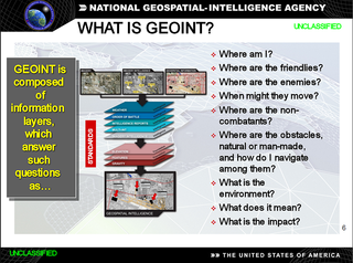
In the United States, geospatial intelligence (GEOINT) is intelligence about the human activity on Earth derived from the exploitation and analysis of imagery, signals, or signatures with geospatial information. GEOINT describes, assesses, and visually depicts physical features and geographically referenced activities on the Earth. GEOINT, as defined in US Code, consists of imagery, imagery intelligence (IMINT) and geospatial information.

Donald MacLean Kerr, Jr. served as the Principal Deputy Director of National Intelligence from 2007 to 2009. He was confirmed by the U.S. Senate on Thursday, October 4, 2007. In March 2009, he received the National Intelligence Distinguished Service Medal.

Gilman Louie is an American technology venture capitalist who got his start as a video game designer and then co-founded and ran the CIA venture capital fund In-Q-Tel. With his company Nexa Corporation he designed and developed multiple computer games such as the F-16 Fighting Falcon flight simulator series. His company later merged with Spectrum Holobyte where he was CEO until its acquisition by Hasbro, after which he became Chief Creative Officer and General Manager of its Games.com group. He has served on a number of boards of directors, including Wizards of the Coast, Niantic, Total Entertainment Network, FASA Interactive, Wickr, Aerospike, the Chinese American International School, Markle Foundation, Digital Promise, and Maxar Technologies. He is chairman of the Federation of American Scientists and Vricon. He is a member of the President’s Intelligence Advisory Board and the U.S. Department of State’s Foreign Affairs Policy Board.

The United States Army Intelligence and Security Command (INSCOM) is a direct reporting unit that conducts intelligence, security, and information operations for United States Army commanders, partners in the Intelligence Community, and national decision-makers. INSCOM is headquartered at Fort Belvoir, Virginia.
The Advanced Technical Intelligence Center for Human Capital Development (ATIC) is a university and industry-focused research, education, and training nonprofit corporation within the Dayton Region. It consolidates technical intelligence education and training in the DoD, national agencies, and civilian institutes and industry.

Letitia A. Long served as a civilian in the U.S. Navy and the Intelligence Community between 1978 and 2014, retiring as the fifth Director the National Geospatial-Intelligence Agency, and the first woman to lead a major U.S. intelligence agency, in October 2014. She currently is the Chairman of the Board for the Intelligence and National Security Alliance (INSA).
Robert Cardillo is a Distinguished Fellow at Georgetown University’s Center for Security and Emerging Technology. Prior to this appointment, he was the sixth Director of the National Geospatial-Intelligence Agency and was sworn in October 3, 2014. He was previously selected by Director of National Intelligence James Clapper to serve as the first Deputy Director of National Intelligence for Intelligence Integration in September 2010. Clapper said in a statement that the position would "elevate information sharing and collaboration" between those who collect intelligence and those who analyze it. Cardillo previously served as deputy director of the Defense Intelligence Agency (DIA). Prior to that, he served as the deputy director for Analysis, DIA, and Director, Analysis and Production, National Geospatial-Intelligence Agency (NGA).
Geographic information systems (GIS) play a constantly evolving role in geospatial intelligence (GEOINT) and United States national security. These technologies allow a user to efficiently manage, analyze, and produce geospatial data, to combine GEOINT with other forms of intelligence collection, and to perform highly developed analysis and visual production of geospatial data. Therefore, GIS produces up-to-date and more reliable GEOINT to reduce uncertainty for a decisionmaker. Since GIS programs are Web-enabled, a user can constantly work with a decision maker to solve their GEOINT and national security related problems from anywhere in the world. There are many types of GIS software used in GEOINT and national security, such as Google Earth, ERDAS IMAGINE, GeoNetwork opensource, and Esri ArcGIS.
TerraGo is a private company based in Sterling, Virginia with offices in Atlanta, Georgia, and the UK that develops location intelligence, geospatial collaboration, GIS applications, GPS data collection software. Founded in 2005, TerraGo is an In-Q-Tel portfolio company. In 2012, TerraGo acquired fellow In-Q-Tel portfolio company Geosemble. Aside from being an In-Q-Tel portfolio company, TerraGo is notable in part for pioneering the patented technology, related standards and best practices upon which GeoPDF and geospatial PDF are based and programs related thereto.

Stu Shea is an American business executive and leader and intelligence professional serving in a leadership capacity to public and private companies, as well as an advisor to government agencies, private equity investors, and academic institutions. Shea is chairman, president and chief executive officer of Peraton, a national security technology company. He is the former president and chief operating officer of Leidos, chief operating officer of Science Applications International Corporation (SAIC), and founder and emeritus chairman of the United States Geospatial Intelligence Foundation.
Intelligence Community Directive 301 is a rescinded United States Intelligence Community Directive issued in 2006 to push emphasis on making open source intelligence the source of first resort among the intelligence community. The 9/11 terrorist attacks drove this directive forward as there was a call for many intelligence disciplines to work collectively on assessing and predicting threats to the United States. Intelligence Community Directive 301 outlined responsibilities and established policies on the intelligence community regarding open source intelligence activities. It was rescinded in 2012.

Leo A. Hazlewood was Director of National Photographic Interpretation Center from February 1991 – September 1993), and Deputy Director of National Imagery and Mapping Agency from July 1997 – January 2000. He also served as Deputy Director of Operations at National Imagery and Mapping Agency.

Major General Robert Alan "Rosie" Rosenberg of United States Air Force was Director of Defense Mapping Agency from July 1985 to September 1987. Throughout his 30-year career with the U.S. Air Force, he was instrumental to the U.S. satellite program. National Geospatial-Intelligence Agency inducted him into its Hall of Fame in 2005.

Justin Poole was the seventh deputy director of the National Geospatial-Intelligence Agency (NGA). As deputy director of NGA, he assisted the director in leading the agency and managing the day-to-day operations of NGA and the National System for Geospatial-Intelligence. He became the deputy director on August 10, 2017, after more than 28 years of service with NGA and its predecessor organizations. He resigned on June 11, 2019, following a Department of Defense probe into allegations of personal misconduct.
Shashi Shekhar is a leading scholar of spatial computing, spatial data science, and Geographic Information Systems (GIS). Contributions include scalable roadmap storage methods and algorithms for eco-routing, evacuation route planning, and spatial pattern mining, along with an Encyclopedia of GIS, a Spatial Databases textbook, and a spatial computing book for professionals. Currently, he is serving as a McKnight Distinguished University Professor, a Distinguished University Teaching Professor, ADC Chair and an Associate Director of the College of Science and Engineering Data Science Initiative at the University of Minnesota.