The Rhine is one of the major European rivers. The river begins in the Swiss canton of Graubünden in the southeastern Swiss Alps. It forms part of the Swiss-Liechtenstein, Swiss-Austrian, and Swiss-German borders. After that the Rhine defines much of the Franco-German border, after which it flows in a mostly northerly direction through the German Rhineland. Finally in Germany, the Rhine turns into a predominantly westerly direction and flows into the Netherlands where it eventually empties into the North Sea. It drains an area of 9,973 km2 and its name derives from the Celtic Rēnos. There are also two German states named after the river, North Rhine-Westphalia and Rhineland-Palatinate.

Nieuwegein is a municipality and city in the Dutch province of Utrecht. It is bordered on the north by the city of Utrecht, the provincial capital. It is separated from Vianen to the south by the river Lek and borders on IJsselstein in the southwest and Houten in the east. Nieuwegein has 64,606 inhabitants as of 1 December 2021.

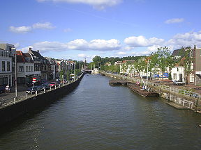
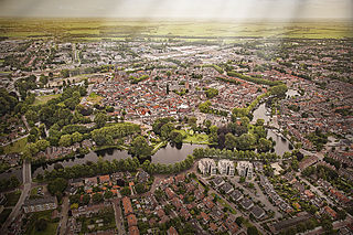
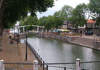
Wijk bij Duurstede is a municipality and a city in the central Netherlands.
Woerden is a city and a municipality in central Netherlands. Due to its central location between Amsterdam, Rotterdam, The Hague, and Utrecht, and the fact that it has rail and road connections to those cities, it is a popular town for commuters who work in those cities.
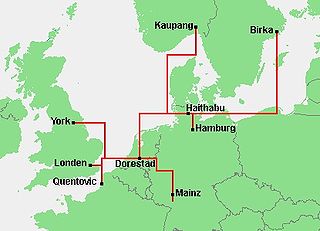
Dorestad was an early medieval emporium, located in the southeast of the province of Utrecht in the Netherlands, close to the modern-day town of Wijk bij Duurstede. It flourished during the 8th to early 9th centuries, as an important port on the northeastern shipping routes due to its proximity to the fork in the Rhine, with access to Germany via the Nederrijn, to the southern Netherlands, northern France, and England, and to the northern Netherlands, northern Germany, and Scandinavia.

The Amsterdam–Rhine Canal is a canal in the Netherlands that was built to connect the port and capital city of Amsterdam to the main shipping artery of the Rhine. Its course follows a generally southeasterly direction as it goes through the city of Utrecht towards Wijk bij Duurstede where it intersects the Lek branch of the Rhine and then continues on to the river Waal near Tiel, with a branch, the Lek Canal, to the Lek near Nieuwegein. The Amsterdam-Rhine Canal is the world's most frequented artificial waterway with an annual average of 100,000 ships.

The Lek is a river in the western Netherlands of some 60 km (37 mi) in length. It is the continuation of the Nederrijn after the Kromme Rijn branches off at the town of Wijk bij Duurstede. The main westbound waterway is hereafter called the Lek River. The Nederrijn is, itself, a distributary branch of the river Rhine.

Cothen is a village in the Dutch province of Utrecht. It is a part of the municipality of Wijk bij Duurstede, and lies about 10 km (6 mi) southeast of Houten.

Nederrijn is the Dutch part of the Rhine from the confluence at the town of Angeren of the cut-off Rhine bend of Oude Rijn (Gelderland) and the Pannerdens Kanaal. The city of Arnhem lies on the right (north) bank of the Nederrijn, just past the point where the IJssel branches off. The Nederrijn flows on to the city of Wijk bij Duurstede, from where it continues as the Lek. The once-important but now small Kromme Rijn branch carries the name "Rhine" towards the city of Utrecht.

The Kromme Rijn is a river in the central Netherlands.

The Vecht is a Rhine branch in the Dutch province of Utrecht. It is sometimes called Utrechtse Vecht to avoid confusion with its Overijssel counterpart. The area along the river is called the Vechtstreek.
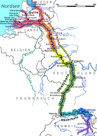
The Lower Rhine flows from Bonn, Germany, to the North Sea at Hook of Holland, Netherlands ; alternatively, Lower Rhine may refer to the part upstream of Pannerdens Kop, excluding the Nederrijn.

Maartensdijk is a village in the Dutch province of Utrecht. It is a part of the municipality of De Bilt, and lies about 4 km north of Bilthoven.
Vreeswijk is a former village and municipality in the Dutch province of Utrecht. The municipality merged with Jutphaas in 1971, and is now the southern half of the town of Nieuwegein. The former village was located on the Lek River, near where it is crossed by the Merwede Canal.

The Oudegracht, or "old canal", runs through the center of Utrecht, the Netherlands. It starts in the southeast of the city. Here the Kromme Rijn and the Vaartse Rijn arrive to meet the original moat of the fortified town, and the Oudegracht goes from there into the center of town. Parts of the Oudegracht follow the original flow of the river Rhine, but there is some disagreement on what parts. The northern part is most likely an early canal connecting the Rhine section to the river Vecht. The southern part was started in 1122, after the water level of the Rhine in Utrecht dropped because of the new dam at Wijk bij Duurstede. The ground excavated was used to raise the sides of the canal, to reduce the chance of flooding. When the city's system of locks was finished in 1275 the water level was constant, enabling the creation of permanently dry cellars and new quays at water level, hence the typical wharfs below street level. Warehouses used to line the canal. Today many of these warehouses have been converted into restaurants and cafés.

The Rhine–Meuse–Scheldt delta is a river delta in the Netherlands formed by the confluence of the Rhine, the Meuse and the Scheldt rivers. In some cases, the Scheldt delta is considered a separate delta to the Rhine–Meuse delta. The result is a multitude of islands, branches and branch names, in which a waterway that appears to be one continuous stream may have numerous separate names for different sections, e.g. Rhine → Bijlands Kanaal → Pannerdens Kanaal → Nederrijn → Lek → Nieuwe Maas → Het Scheur → Nieuwe Waterweg. Since the Rhine contributes most of the water, the term "Rhine Delta" is commonly used, although this name is also used for the delta where the Alpine Rhine flows into Lake Constance. By some calculations, the Rhine–Meuse–Scheldt delta covers 25,347 km2 (9,787 sq mi), making it the largest in Europe.
Godbald was a bishop of Utrecht from 1114 to 1127.
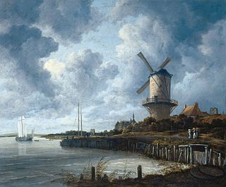
The Windmill of Wijk bij Duurstede is an oil-on-canvas painting by the Dutch painter Jacob van Ruisdael. It is an example of Dutch Golden Age painting and is now in the collection of the Amsterdam Museum, on loan to the Rijksmuseum.