Vanua Lava

Last updated
Vanua Lava
Native name:
Vōnōlav, Vunulava, Vunulāv
Vanua lava.jpg
Map of Vanua Lava
Womtelo Map-Banks-Vanuatu 1000.png
Vanua Lava
Geography
Location Pacific Ocean
Coordinates 13°48′S167°28′E / 13.800°S 167.467°E / -13.800; 167.467
Archipelago Vanuatu, Banks Islands
Area314 km2 (121 sq mi)
Highest elevation921 m (3022 ft)
Highest point Mount Suretamate
Administration
Province Torba Province
Largest settlement Sola
Demographics
Population2,623 (2009)
Pop. density8.35/km2 (21.63/sq mi)

Vanua Lava is the second largest of the Banks Islands in Torba Province, Vanuatu, after slightly larger Gaua.

Contents

It is located about 120 km north-northeast of Espiritu Santo and north of Gaua.

Name

The name Vanua Lava [βanualaβa] comes from the Mota language, which was used as the primary language of the Melanesian Mission. Locally, the island is called Vōnōlav [βonoˈlaɸ] / [βʊnʊˈlaɸ] in Vurës and Mwesen, Vunulava [funulafa] in Vera'a, and Vunulāv [βunuˈlɒ̝ɸ] in Lemerig. In the immigrant language Mwotlap, it is referred to as Apnōlap [apnʊˈlap] (with the locative prefix a-). Cognates in other Torres-Banks languages include Lo-Toga Venielave [βəniəlaˈβə] and Lakon Vanōlav [βanʊˈlaɸ] . All of these terms come from a Proto-Torres–Banks form * βanua laβa "Large Land".

History

Vanua Lava was first sighted by Europeans during the Spanish expedition of Pedro Fernández de Quirós from 25 to 29 April 1606. The island’s name was then charted as Portal de Belén (“Nativity scene” in Spanish). [1]

Vanua Lava was first explored by a New Zealand bishop, George Augustus Selwyn, in 1859. The sulfur deposits of Mt. Suretamate were at one time worked by a French company. Copra is the chief export.

Geography

Location of the Banks Islands in the north of Vanuatu Nh-map.png
Location of the Banks Islands in the north of Vanuatu

The island measures about 25 km north-to-south and 20 km east-to-west. It has a land area of 314 km². The capital of Torba province, Sola, is located on the east side of the island, on Port Patteson.

The highest altitude on the island is 946 metres (3,104 feet). Mount Suretamate (from Mota), also known as Suretimiat or Seretimiat (from Vurës) and Sere'ama (from Lemerig and Vera'a), which stands 921 metres (3,022 feet)) high, is an active volcano: Its last major eruption was in 1965. The island has two natural harbors, Port Patteson in the east and Vureas Bay (Vurës) in the southwest. To the east of the island are the islets of Kwakea and Ravenga. Waterfall Bay lies on the west side of the island.

Natural history

A 14,850 ha tract, encompassing the upper slopes of Mount Suretamate and much of the northeastern coastline of the island, has been recognised as an Important Bird Area (IBA) by BirdLife International because it supports populations of Vanuatu megapodes, Vanuatu imperial pigeons, Tanna fruit doves, red-bellied fruit doves, palm lorikeets, cardinal myzomelas, Vanuatu honeyeaters, fan-tailed gerygones, long-tailed trillers, streaked fantails, Melanesian flycatchers, buff-bellied monarchs, southern shrikebills, Santo thicketbirds and Vanuatu white-eyes. It is also home to seabird breeding colonies of collared and white-necked petrels. Other animals found on the island include coconut crabs and Banks flying foxes. [2]

Population and languages

The population of Vanua Lava was 2,623 in the 2009 census. [3]

Vanua Lava is home to four indigenous languages: [4] [5] Vurës, with about 2000 speakers; Vera'a, with 500; and two dying languages, Mwesen, with 10 speakers, and Lemerig, with only 2 living speakers. Other languages on the island, spoken by migrant communities, include Mwotlap (on the northeastern coast) and Mota (in the east). The language most commonly spoken in Sola, the administrative capital, where people from different language backgrounds meet, is Bislama.

Vanua Lava evidently used to harbour more languages in the past, several of which have disappeared since the mid 19th century. [6]

Transportation

There is an airport on the island (IATA code SLH), to which Air Vanuatu flies three times a week. There is a single road on the island, but few vehicles.

Related Research Articles

<span class="mw-page-title-main">Torba Province</span> Province of Vanuatu

Torba is the northernmost and least populous province of Vanuatu. It consists of the Banks Islands and the Torres Islands.

<span class="mw-page-title-main">Banks Islands</span> Group of islands in Torba, Vanuatu

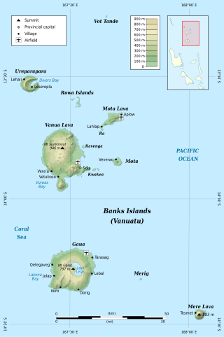
The Banks Islands are a group of islands in northern Vanuatu. Together with the Torres Islands to their northwest, they make up the northernmost province of Torba. The island group lies about 40 km (25 mi) north of Maewo, and includes Gaua and Vanua Lava, two of the 13 largest islands in Vanuatu. In 2009, the islands had a population of 8,533. The island group's combined land area is 780 km2.

<span class="mw-page-title-main">Gaua</span> Island in Vanuatu

Gaua is the largest and second most populous of the Banks Islands in Torba Province in northern Vanuatu. It covers 342 km².

Mwotlap is an Oceanic language spoken by about 2,100 people in Vanuatu. The majority of speakers are found on the island of Motalava in the Banks Islands, with smaller communities in the islands of Ra and Vanua Lava, as well as migrant groups in the two main cities of the country, Santo and Port Vila.

<span class="mw-page-title-main">Mota Lava</span> Island in Vanuatu

Mota Lava or Motalava is an island of the Banks group, in the north of Vanuatu. It forms a single coral system with the small island of Ra.

Qat is the principal god in the oral mythology of the Banks Islands, a small archipelago of northern Vanuatu, Melanesia.

<span class="mw-page-title-main">Mota (island)</span> Island in Vanuatu

Mota is an island in the Banks group of northern Vanuatu. Its population – today about 700 people – speak the Mota language, which Christian missionaries of the Anglican Church used as a lingua franca in parts of Melanesia.

<span class="mw-page-title-main">Ureparapara</span> Island of Vanuatu

<span class="mw-page-title-main">Alexandre François</span> French linguist

Alexandre François is a French linguist specialising in the description and study of the indigenous languages of Melanesia. He belongs to Lattice, a research centre of the CNRS and École Normale Supérieure dedicated to linguistics.

The North Vanuatu languages form a linkage of Southern Oceanic languages spoken in northern Vanuatu.

<span class="mw-page-title-main">Kwakéa</span> Island in Torba Province, Vanuatu

Kwakéa is an islet located east of Vanua Lava in the Banks Islands, Vanuatu. It has a population of 8 people.

<span class="mw-page-title-main">Merelava</span> Island in Vanuatu

Merelava is an island in the Banks Islands of the Torba Province of northern Vanuatu.

<span class="mw-page-title-main">Lemerig language</span> Austronesian language spoken in Vanuatu

Lemerig is an Oceanic language spoken on Vanua Lava, in Vanuatu.

Sola is the capital village of Torba Province in Vanuatu. It is on the island of Vanua Lava.

Mwesen is an Oceanic language spoken in the southeastern area of Vanua Lava Island, in the Banks Islands of northern Vanuatu, by about 10 speakers.

<span class="mw-page-title-main">Vurës language</span> Austronesian language spoken in Vanuatu

Vurës is an Oceanic language spoken in the southern area of Vanua Lava Island, in the Banks Islands of northern Vanuatu, by about 2000 speakers.

Vera'a, also known as Vatrata, is an Oceanic language spoken on the western coast of Vanua Lava Island, in the Banks Islands of northern Vanuatu.

<span class="mw-page-title-main">Rowa Islands</span> Group of islands in Vanuatu

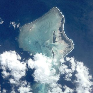
Rowa Islands are an uninhabited archipelago in Torba Province of Vanuatu in the Pacific Ocean. The Rowa are a part of larger Banks Islands archipelago. The islands are a natural border between Melanesia and Polynesia; they are one of the most beautiful places in the South Pacific Ocean and an integral part of a vast system of atolls and reefs.

The Torres–Banks languages form a linkage of Southern Oceanic languages spoken in the Torres Islands and Banks Islands of northern Vanuatu.

Proto-Torres-Banks is the reconstructed ancestor of the seventeen languages of the Torres and Banks Islands of Vanuatu. Like all indigenous languages of Vanuatu, it belongs to the Oceanic branch of the Austronesian languages.

References

References

  1. Kelly, Celsus, O.F.M. La Austrialia del Espíritu Santo. The Journal of Fray Martín de Munilla O.F.M. and other documents relating to the Voyage of Pedro Fernández de Quirós to the South Sea (1605-1606) and the Franciscan Missionary Plan (1617-1627) Cambridge, 1966, p.39, 62.
  2. "Vanua Lava, Mount Sereama". BirdLife Data Zone. BirdLife International. 2021. Retrieved 12 February 2021.
  3. 2623 = sum of Vanua Lava + Kwakea figures in 2009 census: "2009 National Census of Population and Housing: Summary Release" (PDF). Vanuatu National Statistics Office. 2009. Retrieved Nov 23, 2010.{{cite journal}}: Cite journal requires |journal= (help)
  4. Cf. François (2012).
  5. Detailed list and map of the Banks and Torres languages.
  6. François (2012):89-90).