Viaduct

Last updated

Viaduct
Laighmilton1.JPG
The 1812 Laigh Milton Viaduct in Ayrshire – the oldest surviving railway bridge in Scotland
Ancestor Trestle bridge, Box girder bridge
Related Aqueduct
DescendantNone
Carries Expressways, highways, streets, railways
Span rangeShort (multiple)
Material reinforced concrete, prestressed concrete, masonry
MovableNo
Design effortmedium
Falsework requiredavailable for use, since viaducts are all composed of low bridges.

A viaduct is a specific type of bridge that consists of a series of arches, piers or columns supporting a long elevated railway or road. Typically a viaduct connects two points of roughly equal elevation, allowing direct overpass across a wide valley, road, river, or other low-lying terrain features and obstacles. [1] [2] The term viaduct is derived from the Latin via meaning "road", and ducere meaning "to lead". It is a 19th-century derivation from an analogy with ancient Roman aqueducts. [1] Like the Roman aqueducts, many early viaducts comprised a series of arches of roughly equal length.

Contents

Over land

The Ouse Valley Viaduct in Sussex, England Ouse Valley Viaduct 02.jpg
The Ouse Valley Viaduct in Sussex, England

The longest viaduct in antiquity may have been the Pont Serme which crossed wide marshes in southern France. [3] At its longest point, it measured 2,679 meters with a width of 22 meters.

Viaducts are commonly used in many cities that are railroad hubs, such as Chicago, Birmingham, London and Manchester. These viaducts cross the large railroad yards that are needed for freight trains there, and also cross the multi-track railroad lines that are needed for heavy rail traffic. These viaducts provide grade separation and keep highway and city street traffic from having to be continually interrupted by the train traffic. Likewise, some viaducts carry railroads over large valleys, or they carry railroads over cities with many cross-streets and avenues.

Many viaducts over land connect points of similar height in a landscape, usually by bridging a river valley or other eroded opening in an otherwise flat area. Often such valleys had roads descending either side (with a small bridge over the river, where necessary) that become inadequate for the traffic load, necessitating a viaduct for "through" traffic. [4] Such bridges also lend themselves for use by rail traffic, which requires straighter and flatter routes. [5] Some viaducts have more than one deck, such that one deck has vehicular traffic and another deck carries rail traffic. One example of this is the Prince Edward Viaduct in Toronto, Canada, that carries motor traffic on the top deck as Bloor Street, and metro as the Bloor-Danforth subway line on the lower deck, over the steep Don River valley. Others were built to span settled areas, crossing over roads beneath—the reason for many viaducts in London.

Over water

The Millau Viaduct ViaducdeMillau.jpg
The Millau Viaduct

Viaducts over water make use of islands or successive arches. They are often combined with other types of bridges or tunnels to cross navigable waters as viaduct sections, while less expensive to design and build than tunnels or bridges with larger spans, typically lack sufficient horizontal and vertical clearance for large ships. See the Chesapeake Bay Bridge-Tunnel.

The Millau Viaduct is a cable-stayed road-bridge that spans the valley of the river Tarn near Millau in southern France. It opened in 2004 and is the tallest vehicular bridge in the world, with one pier's summit at 343 metres (1,125 ft). The viaduct Danyang–Kunshan Grand Bridge in China was the longest bridge in the world as of 2011. [6]

Land use below viaducts

"Deansgate Locks" bars under Deansgate Metrolink station in Manchester. Deansgate Locks - geograph.org.uk - 1352312.jpg
"Deansgate Locks" bars under Deansgate Metrolink station in Manchester.

Where a viaduct is built across land rather than water, the space below the arches may be used for businesses such as car parking, vehicle repairs, light industry, bars and nightclubs. In the United Kingdom, many railway lines in urban areas have been constructed on viaducts, and so the infrastructure owner Network Rail has an extensive property portfolio in arches under viaducts. [7] In Berlin the space under the arches of elevated subway lines (S-Bahn) is used for several different purposes, including small eateries or bars.

Past and future

Elevated expressways were built in major cities such as Boston (Central Artery), Los Angeles, San Francisco, Seoul, Tokyo and Toronto (Gardiner Expressway). [8] Some were demolished because they were unappealing and divided the city.[ citation needed ] In other cases, viaducts were demolished because they were structurally unsafe, such as the Embarcadero Freeway in San Francisco, which was damaged by an earthquake in 1989. However, in developing nations such as Thailand (Bang Na Expressway, the world's longest road bridge), India (Delhi-Gurgaon Expressway), China, Bangladesh, Pakistan, and Nicaragua, elevated expressways have been built and more are under construction to improve traffic flow, particularly as a workaround of land shortage when built atop surface roads.[ citation needed ]

The Viaduc des Arts, Paris, France. P1060258 Paris XII boulevard Daumesnil arcades rwk.JPG
The Viaduc des Arts, Paris, France.

Other uses have been found for some viaducts. In Paris, France, a repurposed rail viaduct provides a garden promenade on top and workspace for artisans below. The garden promenade is called the Coulée verte René-Dumont while the workspaces in the arches below are the Viaduc des Arts. The project was inaugurated in 1993. Manhattan's High Line, inaugurated in 2009, also uses an elevated train line as a linear urban park.

In Indonesia viaducts are used for railways in Java and also for highways such as the Jakarta Inner Ring Road. In January 2019, the Alaskan Way Viaduct in Seattle was closed and replaced with a tunnel after several decades of use because it was seismically unsafe.[ citation needed ]

See also

Related Research Articles

<span class="mw-page-title-main">Cable-stayed bridge</span> Type of bridge with cables directly from towers

A cable-stayed bridge has one or more towers, from which cables support the bridge deck. A distinctive feature are the cables or stays, which run directly from the tower to the deck, normally forming a fan-like pattern or a series of parallel lines. This is in contrast to the modern suspension bridge, where the cables supporting the deck are suspended vertically from the main cable, anchored at both ends of the bridge and running between the towers. The cable-stayed bridge is optimal for spans longer than cantilever bridges and shorter than suspension bridges. This is the range within which cantilever bridges would rapidly grow heavier, and suspension bridge cabling would be more costly.

<span class="mw-page-title-main">Tunnel</span> Underground passage made for traffic

A tunnel is an underground or undersea passageway. It is dug through surrounding soil, earth or rock, or laid under water, and is enclosed except for the portals, commonly at each end. A pipeline is not a tunnel, though some recent tunnels have used immersed tube construction techniques rather than traditional tunnel boring methods.

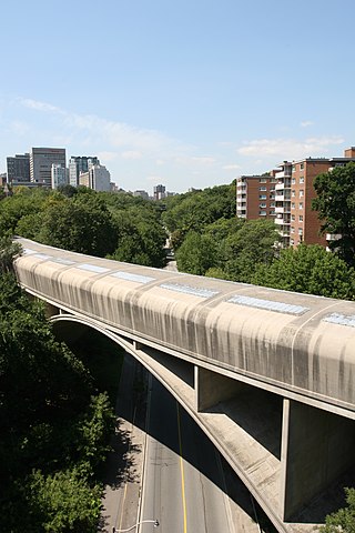
The Frederick G. Gardiner Expressway, commonly known as the Gardiner Expressway or simply the Gardiner, is a partially at grade and elevated municipal expressway in Toronto, Ontario, Canada. Running close to the shore of Lake Ontario, it extends from the foot of the Don Valley Parkway (DVP) in the east, just past the mouth of the Don River, to the junction of Highway 427 and the Queen Elizabeth Way (QEW) in the west, for a total length of 18.0 kilometres (11.2 mi). East of Dufferin Street to just east of the Don River, the roadway is elevated for a length of 6.8 kilometres (4.2 mi), unofficially making it the longest bridge in Ontario, as it runs above Lake Shore Boulevard east of Spadina Avenue. The Gardiner Expressway is wholly owned and operated by the City of Toronto.

<span class="mw-page-title-main">Bridge to nowhere</span> Type of unfinished bridge

A bridge to nowhere is a bridge where one or both ends are broken, incomplete, or unconnected to any roads. If it is an overpass or an interchange, the term overpass to nowhere or interchange to nowhere may be used respectively.

The Don Valley Parkway (DVP) is a municipal freeway in Toronto, Ontario, Canada, which connects the Gardiner Expressway in downtown Toronto with Highway 401. North of Highway 401, it continues as Highway 404. The parkway runs through the parklands of the Don River valley, after which it is named. It has a maximum speed limit of 90 km/h (56 mph) for its entire length of 15.0 km (9.3 mi). It is six lanes for most of its length, with eight lanes north of York Mills Road and four lanes south of Eastern Avenue. As a municipal road, it is patrolled by the Toronto Police Service.

<span class="mw-page-title-main">Prince Edward Viaduct</span> Bridge in Ontario, Canada

The Prince Edward Viaduct System, commonly referred to as the Bloor Viaduct, is the name of a truss arch bridge system in Toronto, Ontario, Canada, connecting Bloor Street East, on the west side of the system, with Danforth Avenue on the east. The system includes the Rosedale Valley phase and the Sherbourne Phase, an embankment built to extend Bloor Street East to the Rosedale Ravine from Sherbourne Street. The Don Valley phase of the system, the most recognizable, spans the Don River Valley, crossing over the Bayview Avenue Extension, the Don River, and the Don Valley Parkway.

<span class="mw-page-title-main">Millau Viaduct</span> Cable-stayed bridge in Occitanie, France

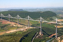
The Millau Viaduct is a multispan cable-stayed bridge completed in 2004 across the gorge valley of the Tarn near Millau in the Aveyron department in the Occitanie Region, in Southern France. The design team was led by engineer Michel Virlogeux and English architect Norman Foster. As of October 2023, it is the tallest bridge in the world, having a structural height of 336.4 metres (1,104 ft).

<span class="mw-page-title-main">Trestle bridge</span> Bridge of short spans supported by rigid frames

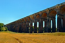
A trestle bridge is a bridge composed of a number of short spans supported by closely spaced frames. A trestle is a rigid frame used as a support, historically a tripod used to support a stool or a pair of isosceles triangles joined at their apices by a plank or beam such as the support structure for a trestle table. Each supporting frame is a bent. A trestle differs from a viaduct in that viaducts have towers that support much longer spans and typically have a higher elevation.

<span class="mw-page-title-main">Silver Jubilee Bridge</span> Bridge in northwest England

The Silver Jubilee Bridge crosses the River Mersey and the Manchester Ship Canal at Runcorn Gap between Runcorn and Widnes in Halton, England. It is a through arch bridge with a main arch span of 361 yards. It was opened in 1961 as a replacement for the Widnes–Runcorn Transporter Bridge. In 1975–77 the carriageway was widened, after which the bridge was given its official name in honour of the Queen's Silver Jubilee. It carries the A533 road and a cantilevered footway. The bridge is recorded in the National Heritage List for England as a designated Grade II listed building. The bridge was closed to vehicles for refurbishment upon the opening of the new Mersey Gateway Bridge, but reopened as a toll bridge in February 2021.

<span class="mw-page-title-main">Old Eastern Avenue Bridge</span> Bridge

The Old Eastern Avenue Bridge consists of two bridges spanning the Don River in Toronto, Ontario, Canada. The north bridge or Gas Line Bridge is a concrete arch bridge built for Consumer's Gas Company and is used by Enbridge Gas to carry a major gas main. The southern Howe truss bridge, similar to Queen Street Viaduct and Sir Isaac Brock Bridge, previously carried traffic on Eastern Avenue but is currently unused.

<span class="mw-page-title-main">Washington Bridge</span> Bridge between Manhattan and the Bronx, New York

The Washington Bridge is a 2,375-foot (724 m)-long arch bridge over the Harlem River in New York City between the boroughs of Manhattan and the Bronx. The crossing, opened in 1888, connects 181st Street and Amsterdam Avenue in Washington Heights, Manhattan, with University Avenue in Morris Heights, Bronx. It carries six lanes of traffic, as well as sidewalks on both sides. Ramps at either end of the bridge connect to the Trans-Manhattan Expressway and the Cross Bronx Expressway.

<span class="mw-page-title-main">Old Main Line Subdivision</span>

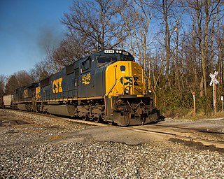
The Old Main Line Subdivision is a railroad line owned and operated by CSX Transportation in the U.S. state of Maryland. The line runs from Relay west to Point of Rocks, and was once the main line of the Baltimore and Ohio Railroad, one of the oldest rail lines in the United States. At its east end, it has junctions with the Capital Subdivision and the Baltimore Terminal Subdivision; its west end has a junction with the Metropolitan Subdivision.

<span class="mw-page-title-main">West Philadelphia Elevated</span> Railroad viaduct in Pennsylvania, United States

The West Philadelphia Elevated, also known as the High Line or Philadelphia High Line, is a railroad viaduct in the western part of Philadelphia, Pennsylvania. Now part of the Harrisburg Subdivision of CSX Transportation, the viaduct was built in 1903 by the Pennsylvania Railroad (PRR) to allow through freight trains to bypass rail yard, industrial sidings, and a passenger station.

<span class="mw-page-title-main">Bergen Hill</span> Lower part of the Hudson Palisades, New Jersey, United States

Bergen Hill refers to the lower Hudson Palisades in New Jersey, where they emerge on Bergen Neck, which in turn is the peninsula between the Hackensack and Hudson Rivers, and their bays. In Hudson County, it reaches a height of 260 feet.

<span class="mw-page-title-main">178th–179th Street Tunnels</span> Disused vehicular tunnels in New York City

The 178th and 179th Street Tunnels are two disused vehicular tunnels in Upper Manhattan in New York City. Originally conceived and constructed under the auspices of Robert Moses, the twin tunnels have been superseded by the Trans-Manhattan Expressway in Washington Heights, which itself runs through a cut with high-rise apartments built over it in places.

<span class="mw-page-title-main">Bridges and tunnels across the Yangtze River</span>

The bridges and tunnels across the Yangtze River carry rail and road traffic across China's longest and largest river and form a vital part of the country's transportation infrastructure. The river bisects China proper from west to east, and every major north–south bound highway and railway must cross the Yangtze. Large urban centers along the river such as Chongqing, Wuhan, and Nanjing also have urban mass transit rail lines crossing the Yangtze.

<span class="mw-page-title-main">Rosedale Valley Bridge</span> Bridge in Ontario, Canada

The Rosedale Valley Bridge is a covered arch bridge located in the northeast part of Downtown Toronto, Ontario. Built in 1966 by architect John B. Parkin, the concrete bridge carries Line 2 trains of the subway across the Rosedale Ravine.

References

  1. 1 2 "viaduct – Definition of viaduct in English by Oxford English Dictionary". OED. Retrieved 21 September 2020.
  2. "Definition of VIADUCT". www.merriam-webster.com. Retrieved 27 March 2018.
  3. Colin O’Connor: Roman Bridges, Cambridge University Press 1993, ISBN   0-521-39326-4, p. 99
  4. Brownlee, Christy (March 2005) "Taking the high road: France's new bridge helps a small town dodge traffic—and set a new world record" SuperScience 16(6): pp.12–15;
  5. Davidsen, Judith (April 1993) "A new "lite" rail viaduct formula: Norman Foster designs a rapid-transit viaduct for Rennes, France" Architectural Record 181(4): p.26;
  6. Longest bridge, Guinness World Records. Last accessed July 2011.
  7. "Light Industrial Units To Let/Rent | Small Industrial Space". Archived from the original on 17 May 2012.
  8. "Toronto built, then demolished an expressway" (PDF). tac-atc.ca. Archived from the original (PDF) on 6 July 2011. Retrieved 27 March 2018.