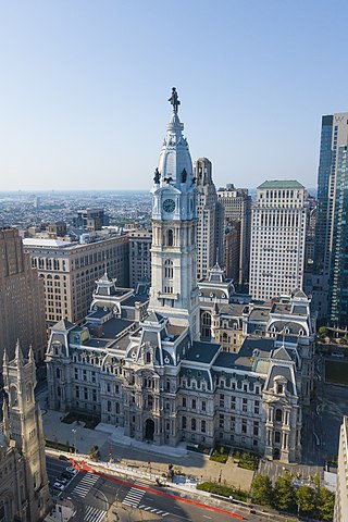
Philadelphia City Hall is the seat of the municipal government of the City of Philadelphia in the U.S. state of Pennsylvania. Built in the ornate Second Empire style, City Hall houses the chambers of the Philadelphia City Council and the offices of the Mayor of Philadelphia.

The Free Library of Philadelphia is the public library system that serves Philadelphia. It is the 16th-largest public library system in the United States. The Free Library of Philadelphia is a non-Mayoral agency of the City of Philadelphia governed by an independent Board of Trustees as per the Charter of the City of Philadelphia. The Free Library of Philadelphia Foundation is a separate 501c3 non-profit with its own board of directors and serves to support the mission of the Free Library of Philadelphia through philanthropic dollars.

Interstate 676 (I-676) is an Interstate Highway that serves as a major thoroughfare through Center City Philadelphia, where it is known as the Vine Street Expressway, and Camden, New Jersey, where it is known as the northern segment of the North–South Freeway, as well as the Martin Luther King Jr. Memorial Highway in honor of civil rights leader Martin Luther King Jr. Its western terminus is at I-76 in Philadelphia near the Philadelphia Museum of Art and Fairmount Park. From there, it heads east and is then routed on surface streets near Franklin Square and Independence National Historical Park, home of the Liberty Bell, before crossing the Delaware River on the Benjamin Franklin Bridge. On the New Jersey side of the bridge, the highway heads south to its southern terminus at I-76 in Gloucester City near the Walt Whitman Bridge. Between the western terminus and downtown Camden, I-676 is concurrent with U.S. Route 30 (US 30).

Center City includes the central business district and central neighborhoods of Philadelphia, Pennsylvania, United States. It comprises the area that made up the City of Philadelphia prior to the Act of Consolidation, 1854, which extended the city borders to be coterminous with Philadelphia County.
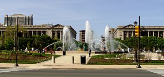
Logan Circle, also known as Logan Square, is an open-space park in Center City Philadelphia's northwest quadrant and one of the five original planned squares laid out on the city grid. The centerpiece of the park is the Logan Circle, a circular area centered on a large water feature, bounded by a traffic circle carrying 19th Street and the Benjamin Franklin Parkway with connections to 18th and 20th streets to the east and west and Race and Vine Streets to the south and north.
Benjamin Franklin Parkway, commonly abbreviated to Ben Franklin Parkway and colloquially called the Parkway, is a boulevard that runs through the cultural heart of Philadelphia, the nation's sixth-largest city as of 2020.
Logan is a neighborhood in the upper North Philadelphia section of the city of Philadelphia, in the U.S. state of Pennsylvania. The majority of the neighborhood falls within the 19141 zip code, but some of it falls within 19140. The neighborhood is sometimes confused with the Olney neighborhood of Philadelphia. Olney Avenue extends from both the Olney and Logan neighborhoods of the city. The Olney Transportation Center is located in Logan.

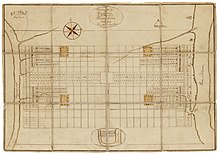
Logan Square is a neighborhood in Philadelphia, Pennsylvania, United States. Bounded by Market Street on the south, Spring Garden Street on the north, Broad Street on the east, and the Schuylkill River on the west, it occupies the northwestern quadrant of Center City. The square for which it is named is one of the five squares central to William Penn's design for Philadelphia. Originally called Northwest Square, it was renamed in honor of James Logan, an 18th-century mayor of Philadelphia.

Market Street, originally known as High Street, is a major east–west highway and street in Philadelphia, Pennsylvania, United States. The street is signed as Pennsylvania Route 3 between 38th Street and 15th Street. A short portion of the road continues west from Cobbs Creek Parkway to Delaware County, adjacent to Philadelphia. The street also serves as the dividing line for the "north" and "south" sides of the city. All north-south addresses in the city start at zero at Market Street.

Horace Trumbauer was a prominent American architect of the Gilded Age, known for designing residential manors for the wealthy. Later in his career he also designed hotels, office buildings, and much of the campus of Duke University.

Franklin Square is one of the five original open-space parks planned by William Penn when he laid out the city of Philadelphia, Pennsylvania, in 1682. It is located in the Center City area, between North 6th and 7th streets, and between Race Street and the Vine Street Expressway (I-676).
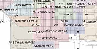
Marconi Plaza is an urban park square located in South Philadelphia, Philadelphia, Pennsylvania, United States. The plaza was named to recognize the 20th-century cultural identity in Philadelphia of the surrounding Italian-American enclave neighborhood and became the designation location of the annual Columbus Day Parade.

Spring Garden is a neighborhood in central Philadelphia, Pennsylvania, bordering Center City on the north. Spring Garden is a neighborhood that combines diverse residential neighborhoods and significant cultural attractions.

Two Logan Square is a highrise office building in Center City Philadelphia just off the Benjamin Franklin Parkway. The building is known for its signature roofline with a backlit clock. It is a companion building to One Logan Square which stands across Cherry Street, and to Three Logan Square, across 18th Street.

The Philadelphia Pennsylvania Temple is a temple of the Church of Jesus Christ of Latter-day Saints in the Logan Square neighborhood of Philadelphia. Completed in 2016, the intent to construct the temple was announced on October 4, 2008, during the church's general conference by LDS Church president Thomas S. Monson. The temple is the church's first in the state of Pennsylvania, and the first temple between Washington, D.C., and New York City.

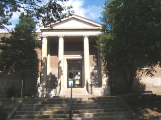
The Board of Education Building, also known as the Board of Education Administration Building, is a historic building in the Logan Square neighborhood of Philadelphia. As the long-time headquarters of what is now the School District of Philadelphia, it was a center of the city's educational system. It was completed in 1932. In recent years, it has been converted to residential use.
The following is a timeline of the history of the city of Philadelphia, Pennsylvania.
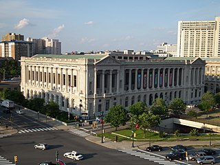
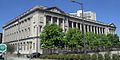
Parkway Central Library also known as Free Library or Central Library is the main public library building and administrative headquarters of the Free Library of Philadelphia system. It is the largest library, and only research library, of 54 library branches in the Free Library system.

The Philadelphia Family Court Building, also known as Juvenile and Domestic Branches of the Municipal Court, is a historic building in Center City Philadelphia and registered under National Park Service's, National Register of Historic Places.