Burkina Faso is a landlocked Sahel country that shares borders with six nations. It lies between the Sahara desert and the Gulf of Guinea, south of the loop of the Niger River, mostly between latitudes 9° and 15°N, and longitudes 6°W and 3°E. The land is green in the south, with forests and fruit trees, and semi-arid in the north. Most of central Burkina Faso lies on a savanna plateau, 198–305 metres (650–1,001 ft) above sea level, with fields, brush, and scattered trees. Burkina Faso's game preserves – the most important of which are Arly, Nazinga, and W National Park—contain lions, elephants, hippopotamus, monkeys, common warthogs, and antelopes. Previously the endangered painted hunting dog, Lycaon pictus occurred in Burkina Faso, but, although the last sightings were made in Arli National Park, the species is considered extirpated from Burkina Faso.

Ghana is a West African country in Africa, along the Gulf of Guinea.

Togo is a small Sub-Saharan state, comprising a long strip of land in West Africa. Togo's geographic coordinates are a latitude of 8° north and a longitude of 1°10′ east. It is bordered by three countries: Benin to the east, with 644 km (400 mi) of border; Burkina Faso to the north, with 126 km (78 mi) of border; and Ghana, with 877 km (545 mi) of border. To the south Togo has 56 km (35 mi) of coastline along the Bight of Benin of the Gulf of Guinea in the North Atlantic Ocean. Togo stretches 579 km (360 mi) north from the Gulf and is only 160 km (99 mi) wide at the broadest point. In total, Togo has an area of 56,785 km2 (21,925 sq mi), of which 54,385 km2 (20,998 sq mi) is land and 2,400 km2 (927 sq mi) is water.

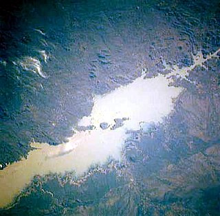
The Akosombo Dam, also known as the Volta Dam, is a hydroelectric dam on the Volta River in southeastern Ghana in the Akosombo gorge and part of the Volta River Authority. The construction of the dam flooded part of the Volta River Basin and led to the subsequent creation of Lake Volta. Lake Volta is the largest man-made lake in the world by surface area. It covers 8,502 square kilometres (3,283 sq mi), which is 3.6% of Ghana's land area. With a volume of 148 cubic kilometers, Lake Volta is the world's third largest man-made lake by volume; the largest being Lake Kariba which contains 185 cubic kilometers of water.
The Cahora Bassa lake—in the Portuguese colonial era known as Cabora Bassa, from Nyungwe Kahoura-Bassa, meaning "finish the job"—is Africa's fourth-largest artificial lake, situated in the Tete Province in Mozambique. In Africa, only Lake Volta in Ghana, Lake Kariba, on the Zambezi upstream of Cahora Bassa, and Egypt's Lake Nasser are bigger in terms of surface water.

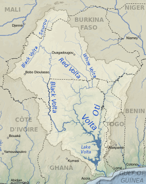
The Black Volta or Mouhoun is a river that flows through Burkina Faso for approximately 1,352 km (840 mi) to the White Volta in Dagbon, Ghana, the upper end of Lake Volta. The source of the Black Volta is in the Cascades Region of Burkina Faso, close to Mount Tenakourou, the highest point of the country. Further downstream it forms part of the border between Ghana and Burkina Faso, and later between Côte d'Ivoire and Ghana. Within Ghana, it forms the border between the Savannah and the Bono regions. The Bui Dam, a hydroelectric power plant, is built on the river, just south of the Bui National Park, which the river bisects.

Lake Volta, the largest artificial reservoir in the world based on surface area, is contained behind the Akosombo Dam which generates a substantial amount of Ghana's electricity. It is completely within the country of Ghana and has a surface area of 8,502 square kilometres. It extends from Akosombo in the south to the northern part of the country.

The Oti River or Pendjari River is an international river in West Africa. It rises in Benin, forms the border between Benin and Burkina Faso, flows through Togo, and joins the Volta River in Ghana.

The Río Negro is a river in southern Brazil and central Uruguay. It rises in the southern highlands of Brazil, just east of Bagé, and flows west across the entire width of Uruguay to the Uruguay River. The course of the Río Negro across Uruguay effectively divides the south and the north of the country. The Río Negro's principal tributaries are Yí River and Tacuarembó River.

The Mono River is the major river of eastern Togo.

Balé is one of the 45 provinces of Burkina Faso, located in its Boucle du Mouhoun Region with Boromo as capital. Its area is 4,596 km2 (1,775 sq mi), and had a population of 297,367 in 2019. The province is known for its Deux Balé Forest, populated by savannah elephant herds. Boromo, the provincial capital, is located on the main road from Ouagadougou to Bobo-Dioulasso. In June 2007, the Canadian mining company, Semafo, open the third gold mine in the country in Mana in the province, with an investment of about $116 million.

The Eastern Region is located in the Eastern part of Ghana and is one of the sixteen administrative regions of Ghana. Eastern region is bordered to the east by the Lake Volta, to the north by Bono East Region and Ashanti region, to the west by Ashanti region, to the south by Central region and Greater Accra Region. Akans are the dominant inhabitants and natives of Eastern region and Akan, Ewe, Krobo, Hausa and English are the main spoken languages. The capital town of Eastern Region is Koforidua.The Eastern region is the location of the Akosombo dam and the economy of the Eastern region is dominated by its high-capacity electricity generation. Eastern region covers an area of 19,323 square kilometres, which is about 8.1% of Ghana's total landform.

Asuogyaman District is one of the thirty-three districts in Eastern Region, Ghana. Originally created as an ordinary district assembly in 1988, which it was created from the former Kaoga District Council. The district assembly is located in the eastern part of Eastern Region and has Atimpoku as its capital town.

Ghana is a multilingual country in which about eighty languages are spoken. Of these, English, which was inherited from the colonial era, is the official language and lingua franca. Of the languages indigenous to Ghana, Akan is the most widely spoken in the south. Dagbani is most widely spoken in the north.
The Volta River Authority (VRA) is the main generator and supplier of electricity in Ghana. They are also the responsible for the maintenance of the hydro power supply plant.
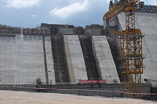
The Bui Dam is a 400-megawatt (540,000 hp) hydroelectric project in Ghana. It is built on the Black Volta river at the Bui Gorge, at the southern end of Bui National Park. The project was a collaboration between the government of Ghana and Sino Hydro, a Chinese construction company. Construction on the main dam began in December 2009. Its first generator was commissioned on 3 May 2013, and the dam was inaugurated in December of the same year.

Ghana generates electric power from hydropower, fossil-fuel, and renewable energy sources such as wind and solar energy. Electricity generation is one of the key factors in order to achieve the development of the Ghanaian national economy, with aggressive and rapid industrialization; Ghana's national electric energy consumption was 265 kilowatt hours per each one in 2009.

The railway stations in Ghana serve a rail network concentrated in the south of the country.
The Kpong Dam, also known as the Akuse Dam, is a hydroelectric power generating dam on the lower Volta River near Akuse in Ghana. It is owned and operated by Volta River Authority. It was constructed between 1977 and 1982. Its power station has a capacity of 148 megawatts (198,000 hp) with all four units running, though the total nameplate capacity is 160 megawatts (210,000 hp).
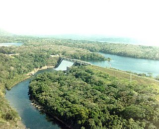
The Madden Dam, completed in 1935, impounds the Chagres River in Panama to form Lake Alajuela, a reservoir that is an essential part of the Panama Canal watershed. The lake has a maximum level of 250 feet (76 m) above sea level. It can store one third of the canal's annual water requirements for the operation of the locks. Since the reservoir is not part of the navigational route, there are fewer restrictions on its water level.