Related Research Articles

A pedestrian crossing is a place designated for pedestrians to cross a road, street or avenue. The term "pedestrian crossing" is also used in the Vienna and Geneva Conventions, both of which pertain to road signs and road traffic.

The term space syntax encompasses a set of theories and techniques for the analysis of spatial configurations. It was conceived by Bill Hillier, Julienne Hanson, and colleagues at The Bartlett, University College London in the late 1970s to early 1980s to develop insights into the mutually constructive relation between society and space. As space syntax has evolved, certain measures have been found to correlate with human spatial behavior, and space syntax has thus come to be used to forecast likely effects of architectural and urban space on users.
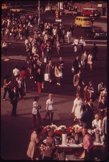
A pedestrian is a person traveling on foot, whether walking or running. In modern times, the term usually refers to someone walking on a road or pavement, but this was not the case historically.

In urban planning, architecture, human geography, landscape architecture, and civil engineering, the term built environment, or built world, refers to the human-made environment that provides the setting for human activity, including homes, buildings, zoning, streets, sidewalks, open spaces, transportation options, and more. It is defined as "the human-made space in which people live, work, and recreate on a day-to-day basis."

Road traffic safety refers to the methods and measures used to prevent road users from being killed or seriously injured. Typical road users include pedestrians, cyclists, motorists, vehicle passengers, horse riders, and passengers of on-road public transport.

Utility cycling encompasses any cycling done simply as a means of transport rather than as a sport or leisure activity. It is the original and most common type of cycling in the world. Cycling mobility is one of the various types of private transport and a major part of individual mobility.
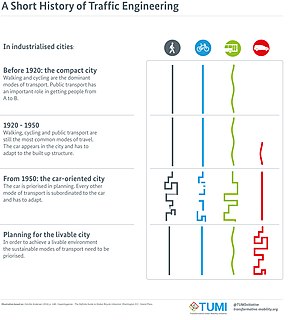
A living street is a street designed in the interests of pedestrians and cyclists. Living streets also act as social spaces, allowing children to play and encouraging social interactions on a human scale, safely and legally. These roads are still available for use by motor vehicles; however, their design aims to reduce both the speed and dominance of motorised transport. This is often achieved using the shared space approach, with greatly reduced demarcations between vehicle traffic and pedestrians. Vehicle parking may also be restricted to designated bays. These street design principles first became popularized in the Netherlands during the 1970s, and the Dutch word woonerf is often used as a synonym for living street.
Spatial network analysis software packages are analytic software used to prepare graph-based analysis of spatial networks. They stem from research fields in transportation, architecture, and urban planning. The earliest examples of such software include the work of Garrison (1962), Kansky (1963), Levin (1964), Harary (1969), Rittel (1967), Tabor (1970) and others in the 1960s and 70s. Specific packages address to suit their domain-specific needs, including TransCAD for transportation, GIS for planning and geography, and Axman for Space syntax researchers.
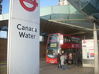
The public transport accessibility level (PTAL) is a method sometimes used in United Kingdom transport planning to assess the access level of geographical areas to public transport.

Shared space is an urban design approach that minimises the segregation between modes of road user. This is done by removing features such as kerbs, road surface markings, traffic signs, and traffic lights. Hans Monderman and others have suggested that, by creating a greater sense of uncertainty and making it unclear who has priority, drivers will reduce their speed, in turn reducing the dominance of vehicles, reducing road casualty rates, and improving safety for other road users.
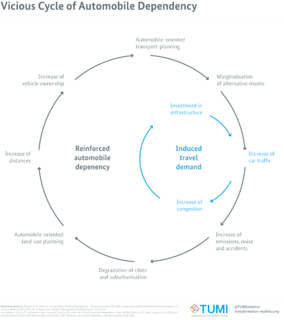
Car dependency is the concept that some city layouts cause cars to be favoured over alternate forms of transportation, such as bicycles, public transit, and walking.

Walkability is a term for planning concepts best understood by the mixed-use of amenities in high-density neighborhoods where people can access said amenities by foot. It is based on the idea that urban spaces should be more than just transport corridors designed for maximum vehicle throughput. Instead, it should be relatively complete livable spaces that serve a variety of uses, users, and transportation modes and reduce the need for cars for travel.
Legible London is a citywide wayfinding system for London, operated by Transport for London (TfL). The system is designed to provide a consistent visual language and wayfinding system across the city, allowing visitors and local residents to easily gain local geographic knowledge regardless of the area they are in. It is the world's largest municipal wayfinding system.
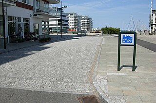
Permeability or connectivity describes the extent to which urban forms permit movement of people or vehicles in different directions. The terms are often used interchangeably, although differentiated definitions also exist. Permeability is generally considered a positive attribute of an urban design, as it permits ease of movement and avoids severing neighbourhoods. Urban forms which lack permeability, e.g. those severed by arterial roads, or with many long culs-de-sac, are considered to discourage movement on foot and encourage longer journeys by car. There is some empirical research evidence to support this view.
In England and Wales, the Manual for Streets, published in March 2007, provides guidance for practitioners involved in the planning, design, provision and approval of new streets, and modifications to existing ones. It aims to increase the quality of life through good design which creates more people-oriented streets. Although the detailed guidance in the document applies mainly to residential streets, the overall design principles apply to all streets within urban areas.

Active mobility, soft mobility, active travel, active transport or active transportation is the transport of people or goods, through non-motorized means, based around human physical activity. The best-known forms of active mobility are walking and cycling, though other modes include running, rowing, skateboarding, kick scooters and roller skates. Due to its prevalence, cycling is sometimes considered separately from the other forms of active mobility.
MAXQDA is a software program designed for computer-assisted qualitative and mixed methods data, text and multimedia analysis in academic, scientific, and business institutions. It is being developed and distributed by VERBI Software based in Berlin, Germany.
Building for Life, Building for Life 12, Adeliladu am Oes 12 Cymru and Building for a Healthy Life are design tools for improving the quality of new homes and neighbourhoods used across England and Wales. The current version in use in England is Building for a Healthy Life .
Junctions is a software package by Transport Research Laboratory. It incorporates the previously separate programs ARCADY, PICADY and OSCADY. The latest version, Junctions 10, was launched Wednesday 3 February 2021.

Technology readiness levels (TRLs) are a method for estimating the maturity of technologies during the acquisition phase of a program. TRLs enable consistent and uniform discussions of technical maturity across different types of technology. TRL is determined during a technology readiness assessment (TRA) that examines program concepts, technology requirements, and demonstrated technology capabilities. TRLs are based on a scale from 1 to 9 with 9 being the most mature technology.
References
- ↑ TRL (2009) PERS On-street Assessment Handbook
- ↑ TRL PERS Software
- ↑ Davies, A. and Clark, S. (2009) Identifying and prioritising walking investment through the PERS audit tool - Walk21 Proceedings, 10th International Conference for Walking, New York, USA, October 2009
- ↑ Allen, D. and Clark, S. (2007) New Directions in Street Auditing: Lessons from the PERS Audits - Walk21 Proceedings, 8th International Conference for Walking, Toronto, Canada October 2007
- ↑ CABE (2007) Paved with Gold
- ↑ CABE (2007) Paved with Gold