History
In prehistoric times, the tribe's territory was (and still is) an excellent salmon-fishing area. It is unknown which tribes were overthrown by the Wanapum tribe when they claimed their ancestral land, or what happened to the original settlers that migrated from NE Asia centuries before the Wanapum and other tribes finally settled in the area. Because of the lost primitive and scarce archeology of the region, these secrets may never be known, and those people never acknowledged.
The tribe made houses from tule and cut over 300 petroglyphs into the basalt cliffs. [1] In 1805, according to the journals of the Lewis and Clark Expedition, the Wanapum, led by their chief Cutssahnem, greeted the expedition and treated its members well, sharing food and entertainment. [3] Captain Clark’s journals provide descriptions of their dwellings, clothing, and physical characteristics.
In the 1800s, a new Native religion, called Washane, Washani or "Dreamer Religion", was created by a spiritual leader of the Wanapum named Smohalla. [4] Adherents to this religion believed that the white man would disappear, if rituals and traditional life was adhered to; instead of participating in armed conflicts, the people prayed. Whether due to this religion or for other reasons, the tribe never fought white settlers, did not sign a treaty with them, and as a result retained no federally recognized land rights.
In 1942 Franklin Matthias allowed about 30 Wanapum to remain in their winter camp, with access to their customary fishing ground in the middle of the federal reservation for the Hanford Engineer Works (part of the Manhattan Project), and provided daily trucks to transport them from their winter camp on the Columbia River. He did not believe that their loyalty could be questioned. But after WWII they were sealed off from graves and cultural sites on the Hanford site. [5]
In 1953 the construction of the Priest Rapids Dam and the Wanapum Dam flooded the riverbanks where the Wanapum had lived in traditional tule houses.

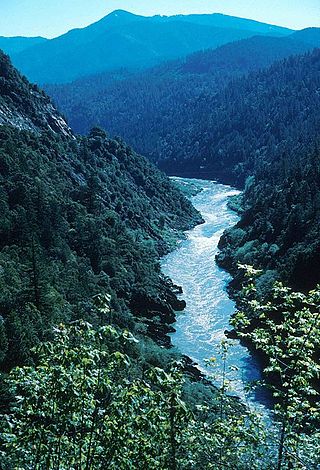
The Columbia River is the largest river in the Pacific Northwest region of North America. The river forms in the Rocky Mountains of British Columbia, Canada. It flows northwest and then south into the U.S. state of Washington, then turns west to form most of the border between Washington and the state of Oregon before emptying into the Pacific Ocean. The river is 1,243 miles long, and its largest tributary is the Snake River. Its drainage basin is roughly the size of France and extends into seven states of the United States and one Canadian province. The fourth-largest river in the United States by volume, the Columbia has the greatest flow of any river entering the Pacific outside of Asia, and the 36th greatest discharge of any river in the world.

Vantage is a census-designated place (CDP) in Kittitas County, Washington, United States. The population was 74 at the 2010 census.

The Yakama are a Native American tribe with nearly 10,851 members, based primarily in eastern Washington state.

The Columbia River Gorge is a canyon of the Columbia River in the Pacific Northwest of the United States. Up to 4,000 feet (1,200 m) deep, the canyon stretches for over eighty miles (130 km) as the river winds westward through the Cascade Range, forming the boundary between the state of Washington to the north and Oregon to the south. Extending roughly from the confluence of the Columbia with the Deschutes River in the east down to the eastern reaches of the Portland metropolitan area, the water gap furnishes the only navigable route through the Cascades and the only water connection between the Columbia Plateau and the Pacific Ocean. It is thus that the routes of Interstate 84, U.S. Route 30, Washington State Route 14, and railroad tracks on both sides run through the gorge.

Wanapum Dam is a run-of-the-river hydroelectric project located on the Columbia River downstream (south) from Vantage, Washington where Interstate 90 crosses the Columbia from Grant County into Kittitas County. It is owned by the Grant County Public Utility District. Its reservoir is named Lake Wanapum.

Priest Rapids Dam is a hydroelectric, concrete gravity dam; located on the Columbia River, between the Yakima Firing Range and the Hanford Nuclear Reservation, and bridges Yakima County and Grant County, in the U.S. state of Washington. The dam is 24 miles south of the town of Vantage, and 47 miles northwest of the city of Richland. It is located at mile marker 397.1 from the mouth of the Columbia. It is owned by the Grant County Public Utility District (PUD). Priest Rapids, for which the dam was named, are now submerged beneath the dam's reservoir.
The Klamath River flows 257 miles (414 km) through Oregon and northern California in the United States, emptying into the Pacific Ocean. By average discharge, the Klamath is the second largest river in California after the Sacramento River. Its nearly 16,000-square-mile (41,000 km2) watershed stretches from the high desert of south-central Oregon to the temperate rainforest of the North Coast. Unlike most rivers, the Klamath begins in a desert region and flows through the rugged Cascade Range and Klamath Mountains before reaching the ocean; National Geographic magazine has called the Klamath "a river upside down".

The Pend Oreille River is a tributary of the Columbia River, approximately 130 miles (209 km) long, in northern Idaho and northeastern Washington in the United States, as well as southeastern British Columbia in Canada. In its passage through British Columbia its name is spelled Pend-d'Oreille River. It drains a scenic area of the Rocky Mountains along the U.S.-Canada border on the east side of the Columbia. The river is sometimes defined as the lower part of the Clark Fork, which rises in western Montana. The river drains an area of 66,800 square kilometres (25,792 sq mi), mostly through the Clark Fork and its tributaries in western Montana and including a portion of the Flathead River in southeastern British Columbia. The full drainage basin of the river and its tributaries accounts for 43% of the entire Columbia River Basin above the confluence with the Columbia. The total area of the Pend Oreille basin is just under 10% of the entire 258,000-square-mile (670,000 km2) Columbia Basin. Box Canyon Dam is currently underway on a multimillion-dollar project for a fish ladder.

The Dalles Lock and Dam is a concrete-gravity run-of-the-river dam spanning the Columbia River, two miles (3 km) east of the city of The Dalles, Oregon, United States. It joins Wasco County, Oregon with Klickitat County, Washington, 192 miles (309 km) upriver from the mouth of the Columbia near Astoria, Oregon. The closest towns on the Washington side are Dallesport and Wishram.
Kettle Falls was an ancient and important salmon fishing site on the upper reaches of the Columbia River, in what is today the U.S. state of Washington, near the Canada–US border. The falls consisted of a series of rapids and cascades where the river passed through quartzite rocks deposited by prehistoric floods on a substrate of Columbia River basalt. The river dropped nearly 50 feet (15 m), and the sound of the falls could be heard for miles away. Kettle Falls was inundated in 1940, as the waters of the reservoir Lake Roosevelt rose behind Grand Coulee Dam, permanently flooding the site.

Celilo Falls was a tribal fishing area on the Columbia River, just east of the Cascade Mountains, on what is today the border between the U.S. states of Oregon and Washington. The name refers to a series of cascades and waterfalls on the river, as well as to the native settlements and trading villages that existed there in various configurations for 15,000 years. Celilo was the oldest continuously inhabited community on the North American continent until 1957, when the falls and nearby settlements were submerged by the construction of The Dalles Dam. In 2019, there were calls by tribal leaders to restore the falls.
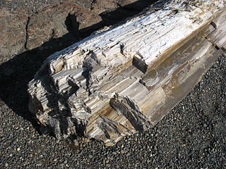
Ginkgo Petrified Forest State Park/Wanapum Recreational Area is a geologic preserve and public recreation area covering 7,124-acre (2,883 ha) on the western shoreline of the Columbia River's Wanapum Reservoir at Vantage, Washington. Petrified wood was discovered in the region in the early 1930s, which led to creation of the state park as a national historic preserve. Over 50 species are found petrified at the site, including ginkgo, sweetgum, redwood, Douglas-fir, walnut, spruce, elm, maple, horse chestnut, cottonwood, magnolia, madrone, sassafras, yew, and witch hazel.
Indigenous peoples of the Northwest Plateau, also referred to by the phrase Indigenous peoples of the Plateau, and historically called the Plateau Indians are Indigenous peoples of the Interior of British Columbia, Canada, and the non-coastal regions of the Northwestern United States.

The Spokan or Spokane people are a Native American Plateau tribe who inhabited the eastern portion of present-day Washington state and parts of northern Idaho in the United States of America.

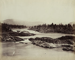
Priest Rapids was a narrow, fast-flowing stretch of the Columbia River, located in the central region of the U.S. state of Washington. It was flooded by the construction of the Priest Rapids Dam in the 1950s.

The Confederated Tribes of Warm Springs is a recognized Native American tribe made of three tribes who put together a confederation. They live on and govern the Warm Springs Indian Reservation in the U.S. state of Oregon.

State Route 243 (SR 243) is a state highway in Grant County, Washington. It travels north–south along the Columbia River for 28 miles (45 km), connecting SR 24 at the Vernita Bridge to SR 26 near Vantage. The highway travels through a predominantly rural and desert area, serving two hydroelectric dams and the communities of Desert Aire, Mattawa, and Beverly.

The Ringold Formation is a geologic formation in Eastern Washington, United States. The formation consists of sediment laid down by the Columbia River following the flood basalt eruptions of the Columbia River Basalt Group, and reaches up to 1,000 feet (300 m) thick in places. It preserves fossils dating back to the Neogene period.

Sentinel Gap is a water gap formed by the Columbia River in the Saddle Mountains, near Mattawa in Washington state. The gap is "a water gap where erosion by the Columbia River was able to keep pace with folding, faulting and uplifting across the Saddle Mountain anticline". During Ice Age floods in which waters from the Channeled Scablands found passage to the Pacific Ocean here and at Wallula Gap, this opening was "repeatedly reamed out, which probably widened and steepened the walls of the gap". Strandlines from the floods can be seen on the basalt walls of the gap.

Locke Island is an island located in the Hanford Reach of the Columbia River in Washington, United States. The island is protected as part of the Hanford Reach National Monument, which was created out of lands surrounding the Hanford Site. The island is an important archeological site and is on the National Register of Historic Places. These cultural resources are being threatened by erosion resulting from a landslide changing the river's course.

