Washington, Georgia

Last updated

Washington, Georgia
City of Washington
Robert Toombs State Historic Site.jpg
Flag of Washington, Georgia.png
Wilkes County Georgia Incorporated and Unincorporated areas Washington Highlighted.svg
Location in Wilkes County and the state of Georgia
Usa edcp relief location map.png
Red pog.svg
Washington
Location of Washington in the US
Coordinates: 33°44′12.5″N82°44′21.5″W / 33.736806°N 82.739306°W / 33.736806; -82.739306
Country Flag of the United States.svg  United States
State Flag of Georgia (U.S. state).svg Georgia
County Wilkes
Settled1774
Incorporated1804
Founded by Stephen Heard
Named for George Washington
Government
   Mayor Bill DeGolian
   Council Washington City Council
Area
[1]
  Total7.75 sq mi (20.08 km2)
  Land7.70 sq mi (19.94 km2)
  Water0.05 sq mi (0.14 km2)
Elevation
607 ft (185 m)
Population
 (2020)
  Total3,754
  Density487.66/sq mi (188.29/km2)
Demonym Washingtonian
Time zone UTC-5 (Eastern (EST))
  Summer (DST) UTC-4 (EDT)
ZIP code
30673
Area code(s) 706/762
FIPS code 13-80704 [2]
GNIS feature ID0356620 [3]
Website cityofwashingtonga.gov

Washington is the county seat of Wilkes County, [4] Georgia, United States. Under its original name, Heard's Fort, it was for a brief time during the American Revolutionary War the Georgia state capital. It is noteworthy as the place where the Confederacy voted to dissolve itself, effectively ending the American Civil War.

Contents

The population was 4,134 as of the 2010 census. The city is often referred to as Washington-Wilkes, to distinguish it from other places named Washington.

History

Heard's Fort was established in 1774 by colonist Stephen Heard. The settlement served as the temporary capital of the new state of Georgia from February 3, 1780, until early 1781. [5]

American Revolutionary War

The Battle of Kettle Creek, one of the most important battles of the American Revolutionary War to be fought in Georgia, was fought on February 14, 1779, in Wilkes County, about eleven miles (17.7 km) from present-day Washington. The American Patriots were victorious, taking 75 prisoners and killing roughly 70 Loyalists, while losing 32 of their own men.

American Civil War

As a child, Alexander H. Stephens had studied at the school in Washington presided over by Presbyterian minister Alexander Hamilton Webster. He later became a politician and was elected as Vice-President of the Confederacy.

No major battles of the Civil War were fought in or near Washington, but the city is notable as the site where Confederate President Jefferson Davis held his last meeting with his cabinet. On April 3, 1865, with Union troops under General Ulysses S. Grant poised to capture the capital at Richmond, Virginia, Davis escaped for Danville, together with the Confederate cabinet.

After leaving Danville, and continuing south, Davis met with his Cabinet for the last time on May 5, 1865, in Washington, along with a hand-picked escort led by Given Campbell, including his personal body guard, Sgt. Joseph A Higgenbotham, Jr., of Amherst/Nelson County, Virginia. The meeting took place at the Heard house [6] (now used as the Georgia Branch Bank Building), with fourteen officials present.

Historic sites

Several historic sites in Washington are on the National Register of Historic Places, including the Wilkes County Courthouse, the Robert Toombs House State Historic Site, the Washington-Wilkes Historical Museum, [7] the Mary Willis Public Library, [8] Cherry Grove Baptist Church Schoolhouse, and the recently restored historic Fitzpatrick Hotel, built in 1898. [9]

Geography

Washington is located at 33°44′7″N82°44′29″W / 33.73528°N 82.74139°W / 33.73528; -82.74139 (33.735394, −82.741420). [10]

According to the United States Census Bureau, the city has a total area of 7.9 square miles (20 km2), of which 7.8 square miles (20 km2) is land and 0.04 square miles (0.10 km2) (0.25%) is water.

Demographics

Historical population
CensusPop.Note
1810 596
1820 69516.6%
1850 462
1870 1,506
1880 2,19946.0%
1890 2,63119.6%
1900 3,30025.4%
1910 3,065−7.1%
1920 4,20837.3%
1930 3,158−25.0%
1940 3,53712.0%
1950 3,8027.5%
1960 4,44016.8%
1970 4,094−7.8%
1980 4,66213.9%
1990 4,279−8.2%
2000 4,2950.4%
2010 4,134−3.7%
2020 3,754−9.2%
U.S. Decennial Census [11]
Washington racial composition 2020 [12]
RaceNum.Perc.
White 1,22632.66%
Black or African American 2,27760.66%
Native American 120.32%
Asian 240.64%
Other/Mixed 1223.25%
Hispanic or Latino 932.48%

As of the 2020 United States census, there were 3,754 people, 1,646 households, and 904 families residing in the city.

Education

The Wilkes County School District holds pre-school to grade twelve, and consists of one primary school, one elementary school, a middle school, and a high school. [13] The district has 116 full-time teachers and over 1,858 students. [14]

Dr. Rosemary Caddell is the Superintendent of Schools. [15]

One of Washington's most lingering mysteries is that of the lost Confederate gold. [16] As the last recorded location of the remaining Confederate gold, the Washington area is thought to be the site where it is buried. Worth roughly $100,000 when it disappeared in 1865, at 2016 prices its value would be around $3.6 million. The cable television channel A&E produced a documentary focusing on this legend.

Notable people

See also

Related Research Articles

<span class="mw-page-title-main">Confederate States of America</span> Unrecognized state in North America (1861–1865)

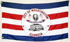
The Confederate States of America (CSA), commonly referred to as the Confederate States (C.S.), the Confederacy, or the South, was an unrecognized breakaway republic in the Southern United States that existed from February 8, 1861, to May 9, 1865. The Confederacy comprised eleven U.S. states that declared secession and warred against the United States during the American Civil War. The states were South Carolina, Mississippi, Florida, Alabama, Georgia, Louisiana, Texas, Virginia, Arkansas, Tennessee, and North Carolina.

<span class="mw-page-title-main">Montgomery County, Georgia</span> County in Georgia, United States

Montgomery County is a county located in the central portion of the U.S. state of Georgia. As of the 2020 census, the population was 8,610. The county seat is Mount Vernon. Montgomery County is part of the Vidalia, GA micropolitan statistical area.

<span class="mw-page-title-main">Danville, Virginia</span> Independent city in Virginia, United States

Danville is an independent city in the Commonwealth of Virginia in the United States. The city is located in the Southside Virginia region and on the fall line of the Dan River. It was a center of tobacco production and was an area of Confederate activity during the American Civil War, due to its strategic location on the Richmond and Danville Railroad. In April 1865 it briefly served as the final capital of the Confederate States before its surrender later that year.

<span class="mw-page-title-main">Wilkes County, Georgia</span> County in Georgia, United States

Wilkes County is a county located in the east central portion of the U.S. state of Georgia. As of the 2020 census, the population was 9,565. The county seat is the city of Washington.

<span class="mw-page-title-main">Toombs County, Georgia</span> County in Georgia, United States

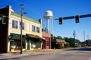
Toombs County is a county located in the east central portion of the U.S. state of Georgia. As of the 2020 census, the population was 27,030. The county seat is Lyons and the largest city is Vidalia. The county was created on August 18, 1905.

<span class="mw-page-title-main">Jeff Davis County, Georgia</span> County in Georgia, United States

Jeff Davis County is a county located in the southeastern part of the U.S. state of Georgia. As of the 2020 census, the population was 14,779. The county seat is Hazlehurst. The county was created on August 18, 1905, and named for Jefferson Davis, the only Confederate president.

<span class="mw-page-title-main">Irwin County, Georgia</span> County in Georgia, United States

Irwin County is a county located in the U.S. state of Georgia. As of the 2020 census, the population was 9,666. The county seat is Ocilla. The county was created on December 15, 1818. It was named for Governor Jared Irwin.

<span class="mw-page-title-main">Crawfordville, Georgia</span> City in Georgia, United States

Crawfordville is a city in Taliaferro County, Georgia, United States. The population was 479 in 2020. The city is the county seat of Taliaferro County.

<span class="mw-page-title-main">Tignall, Georgia</span> Town in Georgia, United States

Tignall is a town in Wilkes County, Georgia, United States. The population was 485 in 2020.

<span class="mw-page-title-main">Chatham, Virginia</span> Town in Virginia, United States

Chatham is a town in Pittsylvania County, Virginia, United States. It is the county seat of Pittsylvania County. Chatham's population was 1,232 at the 2020 census. It is included in the Danville, Virginia Metropolitan Statistical Area. The town was originally called Competition, but the name was changed to Chatham by the Virginia General Assembly on May 1, 1852.

<span class="mw-page-title-main">Robert Toombs</span> American lawyer

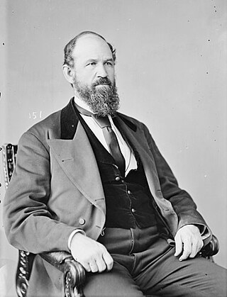
Robert Augustus Toombs was an American politician from Georgia, who was an important figure in the formation of the Confederacy. From a privileged background as a wealthy planter and slaveholder, Toombs embarked on a political career marked by effective oratory, although he also acquired a reputation for hard living, disheveled appearance, and irascibility. He was identified with Alexander H. Stephens's libertarian wing of secessionist opinion, and in contradistinction to the nationalist Jefferson Davis, Toombs believed a Civil War to be neither inevitable or winnable by the South.

<span class="mw-page-title-main">Alexander H. Stephens</span> Confederate States politician, Democrat and 50th governor of Georgia (1812–1883)

Alexander Hamilton Stephens was an American politician who served as the first and sole vice president of the Confederate States from 1861 to 1865, and later as the 50th governor of Georgia from 1882 until his death in 1883. A member of the Democratic Party, he represented the state of Georgia in the United States House of Representatives before and after the Civil War.

<span class="mw-page-title-main">Waynesboro, Georgia</span> City in Georgia, United States

Waynesboro is a city and the county seat of Burke County, Georgia, United States. The population was 5,766 at the 2010 census. It is part of the Augusta, Georgia metropolitan area.

<span class="mw-page-title-main">Richmond in the American Civil War</span> History of Richmond, Virginia during the American Civil War

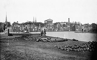
Richmond, Virginia served as the capital of the Confederate States of America during the American Civil War from May 8, 1861, hitherto the capital had been Montgomery, Alabama. Notwithstanding its political status, it was a vital source of weapons and supplies for the war effort, as well as the terminus of five railroads, and as such would have been defended by the Confederate States Army at all costs.

At the end of the American Civil War, the devastation and disruption in the state of Georgia were dramatic. Wartime damage, the inability to maintain a labor force without slavery, and miserable weather had a disastrous effect on agricultural production. The state's chief cash crop, cotton, fell from a high of more than 700,000 bales in 1860 to less than 50,000 in 1865, while harvests of corn and wheat were also meager. The state government subsidized construction of numerous new railroad lines. White farmers turned to cotton as a cash crop, often using commercial fertilizers to make up for the poor soils they owned. The coastal rice plantations never recovered from the war.

<span class="mw-page-title-main">James C. Freeman</span> American politician

James Crawford Freeman was a Georgia planter and slaveowner who after serving in the Confederate States Army during the American Civil War received a pardon and became a banker, jeweler and politician who served one term in the U.S. Representative as a Republican.

<span class="mw-page-title-main">Dudley M. DuBose</span> American politician

Dudley McIver DuBose was an American lawyer, Confederate field officer and politician. He rose to the rank of Brigadier General in the Confederate Army during the American Civil War. Afterward, he later served one term in the United States House of Representatives from Georgia, 1871-1873.

<span class="mw-page-title-main">Robert Toombs House State Historic Site</span> United States historic place

The Robert Toombs House State Historic Site is a historic property located at 216 East Robert Toombs Avenue in Washington, Georgia. It was the home of Robert Toombs (1810–85), a U.S. representative and U.S. senator from Georgia who originally opposed Southern secession but later became a Confederate Cabinet official and then a Confederate general during the American Civil War. Operated as a state historic site, the 19th-century period historic house museum features exhibits about the life of Toombs. The house was declared a National Historic Landmark in 1973.

<span class="mw-page-title-main">Jefferson Davis Memorial Historic Site</span> Historic site in Irwin County, Georgia

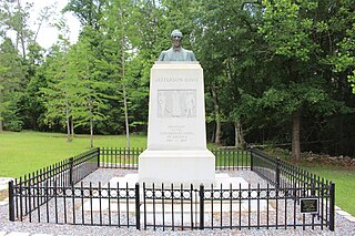
Jefferson Davis Memorial Historic Site is a 12.668-acre (5.127 ha) state historic site located in Irwin County, Georgia that marks the spot where Confederate States President Jefferson Davis was captured by United States Cavalry on Wednesday, May 10, 1865. The historic site features a granite monument with a bronze bust of Davis that is located at the place of capture. The memorial museum, built in 1939 by the Works Progress Administration, features Civil War era weapons, uniforms, artifacts and an exhibit about the president's 1865 flight from Richmond, Virginia to Irwin County, Georgia.

<span class="mw-page-title-main">Wilkes County Courthouse (Georgia)</span> United States historic place

The Wilkes County Courthouse is a historic government building and clock tower located in the city of Washington, Georgia, the seat of Wilkes County. The latest in a series of courthouses in the county's history, the current building was completed in 1904 and since that date has been the official home of Wilkes County's Superior Court, and the base of the county's government. On September 18, 1980, the building was added to the National Register of Historic Places.

References

  1. "2020 U.S. Gazetteer Files". United States Census Bureau. Retrieved December 18, 2021.
  2. "U.S. Census website". United States Census Bureau . Retrieved January 31, 2008.
  3. "US Board on Geographic Names". United States Geological Survey. October 25, 2007. Retrieved January 31, 2008.
  4. "Find a County". National Association of Counties. Retrieved June 7, 2011.
  5. "Washington, Georgia". www.kudcom.com.
  6. "Washington, Georgia". www.kudcom.com.
  7. "Washington, Georgia". www.kudcom.com.
  8. "General Info". n-georgia.com. Retrieved July 14, 2011.
  9. "The Fitzpatrick Hotel in Washington, Georgia – A Brief History". thefitzpatrickhotel.com.
  10. "US Gazetteer files: 2010, 2000, and 1990". United States Census Bureau. February 12, 2011. Retrieved April 23, 2011.
  11. "Census of Population and Housing". Census.gov. Retrieved June 4, 2015.
  12. "Explore Census Data". data.census.gov. Retrieved December 7, 2021.
  13. Georgia Board of Education, Retrieved June 30, 2010.
  14. School Stats, Retrieved June 30, 2010.
  15. "Wilkes County Board of Education". Wilkes County Schools. Retrieved June 16, 2012.
  16. "Washington, Georgia – Lost Confederate Gold". www.kudcom.com.
  17. Associated Press, Thomasville Times Enterprise, "Maj. Gen. Lloyd Brown, Retired Army Officer, Died in Washington," February 18, 1950

Further reading

Government
General information