Water resources management in El Salvador

Last updated
Water resources management in El Salvador [1]
Withdrawals by sector 2000
  • Domestic: 25%
  • Agriculture: 59.4%
  • Industry: 15.6%
Renewable water resources17.75 km3
Surface water produced internally25 km3
Groundwater recharge 6.15 km3
Overlap shared by surface water and groundwater6 km3
Renewable water resources per capita2,755 m3/year
Wetland designated as Ramsar sites1,333 km2 (2010)
Hydropower generation36%

Water resources management in El Salvador is characterized by difficulties in addressing severe water pollution throughout much of the country's surface waters due to untreated discharges of agricultural, domestic and industrial run off. The river that drains the capital city of San Salvador is considered to be polluted beyond the capability of most treatment procedures.

Contents

El Salvador has ample groundwater and partly relies on these supplies for domestic purposes. Deforestation has ravaged the country to the point that very little primary forest remains. This has led to substantial difficulties in managing stormwater when hurricanes and tropical storms make landfall.

Torrential rain leads to deadly floods and mudslides that have claimed many lives in El Salvador. A growing urban population coupled with high levels of water losses in urban centers is also challenging water institutions that are not well coordinated. This leads to inefficient water resources management.

Water management challenges

Water pollution

The Acelhuate River is an important drainage system for El Salvador's capital, San Salvador, and is severely contaminated with heavy metals along with domestic and industrial waste. This water is considered a biohazard, and the contamination is so severe that it is rendered untreatable by treatment methods such as reverse osmosis. Contaminated water from the Acelhuate River flows directly into the Cerron Grande reservoir. [2]

The Cerrón Grande reservoir is overloaded with sewage and industrial waste. In a 2004 study, the El Salvador Ministry of Environment found that the waste is coming from 54 industrial plants, 55 coffee processing plants, seven sugar mills, and 29 sewer systems discharging directly into the reservoir. Cerrón Grande dam was built in 1974 to drive El Salvador's largest hydroelectric project, and the 135 km2 reservoir collects some 3,800 tones of excrement each year from the sewage pipes, as well as factory effluents consisting of heavy metals such as chromium and lead. [3]

The sedimentation volumes in the Cerron Grande Reservoir are dangerously high also and estimated to be as high as 7 million m3 per year which gravely impacts the health of the reservoir. [2] Many shallow aquifers are becoming contaminated from the severe surface pollution, and this is critically challenging as deeper wells are more relied upon to provide potable water.

In El Salvador, rivers and streams in the principal agricultural areas are highly polluted by pesticides, particularly by DDT in cotton cultivations in the south-eastern coastal plains. Concentrations of 3.15 mg of DDT per litre of water have been discovered in the Río Grande de San Miguel. [4]

Flooding and stormwater

El Salvador sits directly in the path of tropical storms and hurricanes as evidenced by Hurricane Mitch in 1998 causing US$400 million in damage. Hurricane Stan in 2005 caused considerable flooding throughout El Salvador, resulted in 67 deaths, and displaced more than 50,000 people. Damages from Stan were estimated at US$355 million. There was a tropical storm in 2008 that also led to major flooding and mudslides and killed 199. [5]

Another determining factor in the severe flood waters that plague El Salvador is deforestation. El Salvador is the second most deforested country in Latin America after Haiti. [6] Much of El Salvador's tree cover has been removed, leaving the country vulnerable to flash flooding. Only an estimated 2 per cent of the tree cover that existed before the 10-year civil war remains. Almost 85 percent of its forested cover has disappeared since the 1960s and less than 6,000 hectares are classified as primary forest. [6]

Urbanization

The urbanized population in El Salvador was 61% in 2008 with an increase of 2% each year. [7] In the case of San Salvador, the urbanized surface of the metropolitan area has increased almost exponentially, from 6.8 km2 in 1935 to 91.5 km2 in 2000. This has mainly taken place in the largest aquifer recharge areas. Because of this, the areas with the highest rate of infiltration have been reduced, whereas the areas with a low infiltration rate of 0.05 mm/hour have increased by the same proportion. [4]

Water resource base

Lempa River
Lempa River.jpg
Sunset over the Lempa river
Physical characteristics
Source 
  location Sierra Madre, Guatemala
  elevation1,200 m (3,900 ft)
Mouth Pacific Ocean
  location
El Playón, Tecoluca, El Salvador
Length422 km (262 mi)
Basin size18,246 km2 (7,045 sq mi)
Discharge 
  average362 m3/s (12,800 cu ft/s)

It is estimated that El Salvador has 17.3 km3 of water resources per year. Approximately 67% or 11.6 km3 of this water is surface water. [8] The remaining 5.7 km3 are found in groundwater which is heavily relied upon because surface water is generally severely polluted. Precipitation levels are the most significant in the higher elevations varying from about 2, 286 mm in the mountain ranges down to 1,448 mm in coastal plains. About 95% of the rainfall occurs from May to October with frequent and severe droughts occurring during the drier months. [2] Around 84% of the surface runoff takes place during the rainy season (May–October) while the remaining 16% will run off during the dry season. [8]

Groundwater and surface water resources

El Salvador counts nearly 360 rivers that connect to form ten hydrographic regions. There are four primary lakes in El Salvador including the Ilopango (72 km2), Guija (44 km2), Coatepeque (24.8 km2), , Olomega ( 24.2 km2) and four reservoirs created by hydroelectric dams discussed in more detail below. El Salvador also obtains about 7.5 km3 of surface water per year from neighboring Honduras and Guatemala. [8] The Cerrón Grande Reservoir, known locally as Lake Suchitlán, is the largest body of fresh water in El Salvador. [9]

The Lempa River watershed dominates El Salvador covering half of the country at 10, 255 km2 and draining 6, 214 million m3. The Lempa is 422 km long and originates in the Sierra Madre and the Sierra del Merendón in southern Guatemala. The river flows in Honduras for 31 km before entering El Salvador in northwest.

Groundwater is heavily relied upon for water supply as a result of polluted surface water, and sufficient supplies of fresh groundwater are available throughout most of the country. Groundwater recharge from infiltration is estimated at 6.15 km3 per year whereby 5.97 km3 is considered base flow that serves to recharge surface waters and therefore has the possibility of being extracted. The remaining unused water passes down through the river system and discharges into the Pacific Ocean. The best aquifers are located in coastal areas and valleys of the central plateau where substantial groundwater aquifers are located at depths of 10–100 meters. [8]

Table: Principal characteristics in hydrological regions of El Salvador.

Hydrographic RegionPrimary riversSurface Area (km2)Annual Runoff (million m3)Rainy season annual runoff (million m3)Dry Season annual runoff (million m3)
ALempa10, 2556, 2145, 217836
BPaz929466358107
CSacramento, Sunza65936931751
DSan Pedro, Sonsonate, Banderas875776654123
EMaridinga, Tihuapa1,14635931050
FComalapa, Guayabo1,71788680495
GAfluentes de la Bahia de Jiquilisco958618502115
HGrande de San Miguel2, 2501,161985175
IAfluentes del Golfo de Fonseca80429929633
JSirama y Guascorán1,34847942356
SubTotal20,94111,6279.8671,642
Total with Guatemala and Honduras runoff totals added (regions A, B, J)31,84117,76815,0172,632

Source: FAO 2000

Water resources management by sector

The average per capita availability of water in El Salvador is less than 2,800 m3/year. Per capita annual extraction is 118 m3 representing about 4.3% of available supplies. Agriculture uses about 60%, domestic needs are around 24%, and industrial usage is 16%. [4]

Water coverage and usage

Access to an improved water source in El Salvador was estimated at 76% in 2006. Urban access was 90%, including about 13% lacking a piped connection to the house. Access in rural areas in 2006 was 50%, however only 38% of this total had a piped connection to the house. Most water in rural areas is drawn from groundwater wells. [10]

Irrigation and drainage

Potential surface area for irrigation if only considering soil type is around 676,000 acres (2,740 km2); however, when adequate availability of water is also considered, the potential surface area for irrigation is about 500,000 acres (2,000 km2). Approximately 56% of water available for irrigation is drawn from surface water while the rest is supplied from groundwater. The highest potential for irrigation is located in the coastal plains where the best groundwater is located. About 24% of the total potential area is classified as having "good" potential, while 60% is classified as having a "moderate" potential, and finally about 15% is classified as having potential with substantial limitations. [8]

The private sector for irrigation has grown substantially since 1950 when only 4,000 acres (16 km2) were under irrigation by the private sector. By 1960, there were 40,000 acres (160 km2) irrigated by the private sector and in 1995, 57,000 acres (230 km2) were being irrigated under private control. A concerted effort to develop the irrigation sector between 1966 and 1991 was put forth by the Ministry of Agriculture (MAG) through their General Directorate of Irrigation and Drainage. MAG enacted irrigation districts in Zapotitán (7,400 acres), and Atiocoyo (9,760 acres) with an investment of US $24.7 million and later developed the Lempa-Acahuapa district at a cost of US $21.2 million. [8]

Since 1975, growth in private sector irrigation has stabilized where grass crops have been replaced with higher value crops with a larger profit margin. The distribution of publicly managed irrigation are located mostly in the Sonsonate, Sensunapán, Banderas, and San Pedro watersheds. Public irrigation projects are also prevalent in other areas where good water and soil are located such as the Lempa River, Titihuapa, Sucio, Torola, Grande, and Suquiapa basins. The beneficiaries of public irrigation are organized into 36 associations. [8]

Total surface area with irrigation drainage problems was estimated at 370,658 acres (1,500.00 km2) where most of this land is located in coastal plains. These coastal regions are home to many mangroves and marshes, therefore land remains saturated. There have been successful past efforts to pump off or convey excess water left behind after the rainy season. While drainage is a problem, salinity problems have not been widely detected in the soil. [8]

Hydroelectricity

Hydroelectric potential is estimated at 1,889 MW where 1,409 MW of this potential is on the Lempa River. However, only 21% of the potential of the Lempa River is utilized. [2] CEL (Comisión Hidroeléctrica del Río Lempa) is a public entity that generates over 90% of the hydroelectric output of El Salvador. [11] Four projects on the Lempa River constitute all of the hydroelectricity generation in El Salvador and account for 41% of the total electricity produced in the country.

Projects include: [11]

New Hydroelectric projects include:

Twenty-five agencies share responsibility for overseeing the water resources of El Salvador. There is currently no mechanism for coordinating their efforts, which creates duplication and inefficient use of resources. The El Salvador Congress charged the Secretaria Ejecutiva del Medio Ambiente (SEMA) with the responsibility of setting the national environmental regulatory policy and to also enforce its compliance. As of 1998, land use regulations rested with the Administracion Nacional de Acueductos y Alcantarillados (ANDA) but these regulations were lacking the necessary enforcement tools. Although there is a general lack of enforcement, laws for regulating discharge of domestic and industrial wastes exist, but only for new industries. [2]

Institutional framework

Cooperation with Guatemala and Honduras

The upper watershed of the Lempa River is shared by Guatemala, El Salvador, and Honduras, as outlined in the Trifinio Plan, which was established and signed by the aforementioned countries to address economic and environmental problems in the Lempa River basin, and foster cooperation and regional integration. The Trifinio plan or treaty sought to provide a more viable and effective alternative to unilateral development thereby concentrating on greater multinational integration. [22]

The Trifinio region covers an area of about 7,500 km2 in the border areas of Honduras, Guatemala, and El Salvador. The region is made up of 45 municipalities whereby 22 belong to Honduras within the departments of Ocotepeque and Copán, 15 are situated in Guatemala corresponding to the departments of Chiquimula and Jutiapa, and 8 are in the departments of Santa Ana and Chalatenango in El Salvador. [23] In the early stages of the Trifinio Plan's development, the commission studied three international river basins, and in 1987 they developed a new plan involving the Lempa River Basin, the Ulúa River, and the Motagua River. However, the Motagua and Ulúa rivers were eventually dropped, leaving the Lempa River as the Trifinio Plan's primary focus. [22]

In 1996, the governments of El Salvador, Honduras, and Guatemala signed an agreement to cooperate on formulating a development plan for their shared boundary region. In 1998, the signatories completed the Central American Action Plan for integrated development of water resources to combat water pollution and promote the sustainable development of Central America's shared water resources by jointly developing watershed management plans. These plans included reforestation efforts which concluded in the second phase of the Trifinio Plan in 1997. By 2000 new efforts were initiated to begin managing the upper Lempa River Basin. [22]

Ramsar wetland sites in El Salvador

Lake Olomega
Olomega lrg.jpg
LocationSouth-Eastern El Salvador
Coordinates 13°19′N88°04′W / 13.317°N 88.067°W / 13.317; -88.067
Primary inflows Río Grande de San Miguel
Basin  countriesEl Salvador

Wetlands in El Salvador serve many crucial water management services such as flood control, groundwater replenishment, natural water purification, and are also productive fish and shrimp ecosystems. The wetlands within the Bahía de Jiquilisco for example are primarily mangrove forests that serve to protect against tidal surges when hurricanes and tropical storms strike. Without these forests, tidal surges would lead to the salination of fresh groundwater further inland which would contaminate supplies for domestic and agricultural uses.

The Ramsar Convention wetland sites: [24]

Potential climate change impacts

The Global Climate Risk Index [25] constructed for the period between 1997 and 2006 and covering both human and economic impacts, ranks El Salvador the 30th most at risk country in the world. [26] According to climate scenarios developed by researchers for El Salvador, the following (below) climate changes are likely to occur between 2070 and 2099 [27] and adversely impact groundwater, hydropower output, and flood control management efforts.

The Drought Response and Mitigation Project in El Salvador, implemented by the Red Cross in 2002 helped to mitigate the effects of droughts affecting the country. The objective of this initiative was to increase the capacity of subsistence farmers in the east of the country to better respond to adverse effects of climate conditions, by providing technical assistance to diversify and market crops, reforestation using fruit trees, use of organic fertilizers and small scale irrigation systems. [28]

See also

Related Research Articles

<span class="mw-page-title-main">Geography of El Salvador</span> Overview of countrys geological attributes

El Salvador is a country in Central America. Situated at the meeting point of three tectonic plates, it is highly seismologically active and the location of numerous earthquakes and volcanic eruptions. The country has a tropical climate.

<span class="mw-page-title-main">Cabañas Department</span> Department of El Salvador

Cabañas is a department of El Salvador in the north central part of the country. Its capital is Sensuntepeque and it is one of coolest parts of El Salvador. Classified as a department in February 1873, it covers an area of 1,103.5 km2 (426.1 sq mi) and has over 164,900 inhabitants. The other major city of the department is Ilobasco. Agricultural produce includes coffee, sugar cane and sesame seeds, as well as dairy products. Gold, silver and copper are the principal minerals mined in the department. Its main industrial activity is oriented to manufacture of potteries, cheese, lime and also distilleries.

<span class="mw-page-title-main">Suchitoto</span> Municipality in Cuscatlan, El Salvador

Suchitoto is a municipality in the Department of Cuscatlán, El Salvador that has seen continuous human habitation long before Spanish colonization. Within its municipal territory, Suchitoto holds the site of the original founding of the Villa of San Salvador in 1528 that existed for a short time before the site was abandoned. In more recent times, the municipality has prospered even after the severe effects of civil war in El Salvador that lasted between 1980 - 1992 and saw the population of Suchitoto decrease from 34,101 people in 1971 to 13,850 by 1992. It has become an important tourist destination partly due to its well conserved colonial architecture and cobblestone roads that provide a sense of Spanish colonial living. This rise in tourism has attracted service sector businesses to open up in the small city including hostels, restaurants, and picturesque cafes. As a result of tourism, many arts and cultural spaces have opened up in Suchitoto that are also providing positive alternative opportunities for youth in the community. According to the 2007 Official Census, the small city has a population of 24,786 people with 7,654 people living in the urban area and 17,132 people living in the rural communities.

Access to drinking water and sanitation in El Salvador has been increased significantly. A 2015 conducted study by the University of North Carolina called El Salvador the country that has achieved the greatest progress in the world in terms of increased access to water supply and sanitation and the reduction of inequity in access between urban and rural areas. However, water resources are heavily polluted and the great majority of wastewater is discharged without any treatment into the environment. Institutionally a single public institution is both de facto in charge of setting sector policy and of being the main service provider. Attempts at reforming and modernizing the sector through new laws have not borne fruit over the past 20 years.

<span class="mw-page-title-main">Electricity sector in El Salvador</span>

El Salvador's energy sector is largerly focused on renwables. El Salvador is the largest producer of geothermal energy in Central America. Except for hydroelectric generation, which is almost totally owned and operated by the public company CEL, the rest of the generation capacity is in private hands. With demand expected to grow at a rate of 5% in the coming years, the Government's 2007 National Energy Strategy identified several hydroelectric and geothermal projects as the best option to meet demand in the future and to diversify the country's energy mix.

Water resources management is a significant challenge for Mexico. The country has in place a system of water resources management that includes both central (federal) and decentralized institutions. Furthermore, water management is imposing a heavy cost to the economy.

The water resources management system in Uruguay has been influenced by the general sense of water as an abundant resource in the country. Average annual rainfall is 1,182 mm, representing a contribution of 210 km3 annually throughout its territory. In 2002, the per capita renewable water resources was 41,065 cubic meters, way above the world average 8,467 m3 in 2006. Uruguay also shares one of the largest groundwater reserves in the world, the Guarani Aquifer, with Brazil, Argentina, Paraguay. The Guarani aquifer covers 1,200,000 square kilometers and has a storage capacity of 40,000 km3.

The Cerrón Grande Hydroelectric Dam spans the Lempa River 78 km (48 mi) north of San Salvador in the municipalities of Potonico, (Chalatenango) and Jutiapa (Cabañas) in El Salvador.

<span class="mw-page-title-main">Lempa River</span> River that flows through Guatemala, El Salvador and Honduras

The Lempa River is a 422-kilometre-long (262 mi) river in Central America.

Water resources management (WRM) in Honduras is a work in progress and at times has advanced; however, unstable investment and political climates, strong weather phenomena, poverty, lack of adequate capacity, and deficient infrastructures have and will continue to challenge developments to water resource management. The State of Honduras is working on a new General Water Law to replace the 1927 Law on Using National Waters and designed to regulate water use and management. The new water law will also create a Water Authority, and the National Council of Water Resources which will serve as an advising and consultative body.

The Choluteca river basin lies on the hot and dry southern Pacific coast of Honduras, and is bordered by Nicaragua to the east. The name Choluteca, thought to mean ‘broad valley,’ originates from the indigenous Chorotega tribe who inhabited the region prior to Spanish conquest. The Choluteca river and its tributaries together form the Cabeceras catchment located in southern Honduras where it stretches over four administrative departments covering 7,848 km2 and drains into the Pacific Ocean. The Choluteca river basin provides water to the capital city of Tegucigalpa with population around 1 million inhabitants.

<span class="mw-page-title-main">Water resources management in Argentina</span>

Water resources management (WRM) functions in Argentina are handled by multiple institutions operating at the national, provincial, and river basin level, with a variety of functions and jurisdictions. On the national level, the National Institute for Water and the Environment (INA) and the National Water and Sanitation Utility (AySA) are charged with the duties of researching, water resources preservation, developing services, and implementing water projects.

Cimarron Hydroelectric Power Project a hydroelectric power plant in El Salvador, that was to start construction in 2010. The plant would have been be located in the upper basin of the Lempa River, upstream of the Cerrón Grande Hydroelectric Dam. The proposed location of the dam was between the towns of Agua Caliente, Chalatenango on the left shore and Metapán, Santa Ana, on the right shore. A tunnel would divert water from the Lempa River to a powerhouse and substation to be built near Agua Caliente. With an estimated capacity of 261 megawatts, the project would have increased El Salvador's total generation capacity by almost 25%.

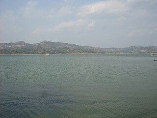
Costa Rica is divided into three major drainage basins encompassing 34 watersheds with numerous rivers and tributaries, one major lake used for hydroelectric generation, and two major aquifers that serve to store 90% of the municipal, industrial, and agricultural water supply needs of Costa Rica. Agriculture is the largest water user demanding around 53% of total supplies while the sector contributes 6.5% to the Costa Rica GDP. About a fifth of land under cultivation is being irrigated by surface water. Hydroelectric power generation makes up a significant portion of electricity usage in Costa Rica and much of this comes from the Arenal dam.

Water resources management in Nicaragua is carried out by the National water utility and regulated by the Nicaraguan Institute of water. Nicaragua has ample water supplies in rivers, groundwater, lagoons, and significant rainfall. Distribution of rainfall is uneven though with more rain falling on an annual basis in the Caribbean lowlands and much lower amounts falling in the inland areas. Significant water resources management challenges include contaminated surface water from untreated domestic and industrial wastewater, and poor overall management of the available water resources.

Guatemala faces substantial resource and institutional challenges in successfully managing its national water resources. Deforestation is increasing as the global demand for timber exerts pressure on the forests of Guatemala. Soil erosion, runoff, and sedimentation of surface water is a result of deforestation from development of urban centers, agriculture needs, and conflicting land and water use planning. Sectors within industry are also growing and the prevalence of untreated effluents entering waterways and aquifers has grown alongside.

Ricardo Ovidio Valencia was a Salvadoran footballer who played most of his career in C.D. FAS.

<span class="mw-page-title-main">Hanabanilla Dam</span> Dam and Reservoir in Cuba

The Hanabanilla Dam is an embankment dam on the Hanabanilla River near the village of El Salto del Hanabanilla in Villa Clara Province, Cuba. The purpose of the dam is to provide water for irrigation and municipal uses and to generate hydroelectric power.

<span class="mw-page-title-main">Canton El Tablon</span> Flooded locality in El Salvador

Canton El Tablón belonged to the Municipality of Suchitoto, Cuscatlan, El Salvador. El Tablón was one of many cantons in the surrounding area that was flooded as a result of the Cerron Grande Hydroelectric Dam built in El Salvador between 1972-1976 that created the artificial Lake Suchitlán. According to former residents of El Tablon, the area was divided up into four main wikt:caseríos or hamlets, Caserio La Hacienda Vieja, Caserio Los Figueroas, Caserio Valle El Tablón, and Caserio Los Palitos. It is unclear where the name El Tablon originated from, but according to local historians, an aldea or village/hamlet of El Tablón existed prior to 1860 that was formed through a municipal ejido. An ejido was commonly owned municipal land granted by the Spanish Crown to governing bodies in the Spanish Empire. These lands were considered vacant or unused land in some cases belonging to existing indigenous communities.

<span class="mw-page-title-main">Cerrón Grande Reservoir</span> Reservoir in northern El Salvador

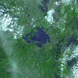
The Cerrón Grande Reservoir, also known locally as Lake Suchitlán, is a reservoir in northern El Salvador and the largest body of fresh water in the country. The reservoir was filled between 1973 and 1976, subsequent to the construction of the Cerrón Grande Hydroelectric Dam. The Cerrón Grande Reservoir is among the most polluted bodies of fresh water in Central America.

References

  1. FAO Aquastat 19882008
  2. 1 2 3 4 5 U.S. Army Corps of Engineers (1998). "Water Resources Assessment of El Salvador" (PDF). U.S. Army Corps of Engineers. Retrieved 2010-03-19.
  3. Barrera, A. (2007-05-17). "Contaminated Salvador lake is mystery bird magnet". Reuters. Retrieved 2010-03-19.
  4. 1 2 3 BALLESTERO M.; REYES V.; ASTORGA Y. (2000). "Groundwater in Central America: Its Importance, Development and Use, with Particular Reference to Its Role in Irrigated Agriculture" (PDF). International Water Management Institute. pp. 100–128. Retrieved 2010-03-22.
  5. US Department of State (2010). "Background Note: El Salvador". US Department of State. Retrieved 2010-03-25.
  6. 1 2 Taylor J. (2005-10-05). "El Salvador flood disaster worsened by deforestation". The Independent. London. Archived from the original on March 24, 2010. Retrieved 2010-03-25.
  7. CIA (2008). "Country profile: El Salvador". CIA. Retrieved 2010-03-22.
  8. 1 2 3 4 5 6 7 8 FAO (2000). "EL Salvador". FAO. Retrieved 2010-03-20.
  9. "Descripción de embalses de El Salvador" (PDF). Organismo Internacional Regional de Sanidad Agropecuaria (OIRSA). 2005. Retrieved 2009-05-04.
  10. UNICEF's Joint Monitoring Program (JMP) (2010). "Estimates for the use of Improved Drinking-Water Sources". UNICEF. Archived from the original on March 22, 2010. Retrieved 2010-03-23.
  11. 1 2 "Central Hidroeléctrica Cerrón Grande". Comisión Ejecutiva Hidroeléctrica del Río Lempa (CEL). 2007. Retrieved 2010-03-20.
  12. "Proyecto Hidroeléctrico El Cimarrón". CEL. Retrieved 2010-03-19.
  13. Supreme Court of El Salvador (1961). "LEY DE LA ADMINISTRACION NACIONAL DE ACUEDUCTOS Y ALCANTARILLADOS" (PDF). Supreme Court of El Salvador. Retrieved 2010-03-22.
  14. Government of El Salvador (2007). "Approval by a Government Board" (PDF). Government of El Salvador. Retrieved 2010-03-22.
  15. ANDA (2010). "Administración Nacional de Acueductos y Alcantarillados" (in Spanish). ANDA. Retrieved 2010-03-20.
  16. "MINISTERIO DE AGRICULTURA Y GANADERÍA DE EL SALVADOR" (in Spanish). DGFCR. 2010. Retrieved 2010-03-20.
  17. CEL (2010). "Comisión Ejecutiva Hidroeléctrica del Río Lempa" (in Spanish). CEL. Retrieved 2010-03-20.
  18. SNET (2010). "Comisión Ejecutiva Hidroeléctrica del Río Lempa" (in Spanish). SNET. Retrieved 2010-03-20.
  19. MARN (2010). "Ministry of Environment and Natural Resources" (in Spanish). MARN. Retrieved 2010-03-20.
  20. FIS (2010). "Fondo de Inversion Social de El Salvador" (in Spanish). FIS. Retrieved 2010-03-23.
  21. MSPAS (2010). "Ministerio de Salud Pública y Asistencia Social" (in Spanish). MSPAS. Retrieved 2010-03-23.
  22. 1 2 3 López A. (2004). "Environmental Conflicts and Regional Cooperation in the Lempa River Basin The Role of Central America´s Plan Trifinio" (PDF). The Environmental Change and Security Project (ECSP) Woodrow Wilson International Center for Scholars. pp. 13–15. Retrieved 2010-03-25.
  23. Artiga R. (2003). "Water Conflict and Cooperation/Lempa River Basin". UNESCO. Retrieved 2010-03-25.
  24. Ramsar (2010). "The Annotated Ramsar List of Wetlands of International Importance". Ramsar. Retrieved 2010-03-22.
  25. Harmeling, S. (2007). "GLOBAL CLIMATE RISK INDEX 2008" (PDF). Germanwatch. Retrieved 2010-03-22.
  26. SICA (2008). "Climate Change Aspects in Agriculture El Salvador Country Note" (PDF). Central American Integration System (SICA). Retrieved 2010-03-22.
  27. Maurer, E., Wood, A. (2008). "Central America Climate Change: Implications for the Rio Lempa" (PDF). Hydrology and Earth System Sciences. doi: 10.5194/hessd-5-3099-2008 . Retrieved 2010-03-22.{{cite journal}}: CS1 maint: multiple names: authors list (link)
  28. UNFCCC (2003). "Drought-resistant agriculture in El Salvador". UNFCCC. Retrieved 2010-03-22.