Waterfront West LRT

Last updated

Waterfront West LRT
Overview
StatusCancelled in 2010, but revived in 2017 by the Waterfront Transit Reset study
Locale Toronto, Ontario
Termini
Service
Type Streetcar
System Toronto streetcar system
Operator(s) Toronto Transit Commission
Route map

Contents

BSicon v-CONTg.svg
BSicon v-STR.svg
BSicon uexlCONTg@G.svg
BSicon uexLSTR.svg
BSicon exlINT-L.svg
BSicon dINT.svg
BSicon uexINT-R.svg
Union
VIA Rail Canada simplified.svg GO Transit logo.svg TTC - Line 1 - Yonge-University-Spadina line.svg BSicon CLRV.svg
BSicon v-STR.svg
BSicon uexLSTR.svg
Stops to be
determined
BSicon udCONTgq.svg
BSicon mdKRZu.svg
BSicon uexTINT.svg
BSicon uCONTfq.svg
Spadina
BSicon CLRV.svg   510  
BSicon v-STR.svg
BSicon uexLSTR.svg
BSicon udCONTgq.svg
BSicon mdKRZu.svg
BSicon uexTINT.svg
BSicon uCONTfq.svg
Bathurst
BSicon CLRV.svg   511  
BSicon v-STR.svg
BSicon lhSTRc2.svg
BSicon RP4c2.svg
BSicon uexLLSTR2.svg
BSicon lhSTR3.svg
BSicon RP43+n.svg
BSicon v-STR.svg
BSicon lhSTR+1.svg
BSicon RP4s+1.svg
BSicon RP4c4.svg
BSicon lhSTRc4.svg
BSicon uCONT1+f.svg
BSicon uexLLSTR+4.svg
BSicon CLRV.svg   509  
BSicon v-STR.svg
BSicon lhSTR.svg
BSicon RP4.svg
BSicon uHST.svg
Fleet
BSicon v-STR.svg
BSicon lhSTR.svg
BSicon RP4.svg
BSicon uHST.svg
Strachan
BSicon v-STR.svg
BSicon lhSTR.svg
BSicon RP4.svg
BSicon uSHI1r.svg
BSicon dINT-L.svg
BSicon RP4.svg
BSicon lhSTR.svg
BSicon lINT-M.svg
BSicon ldINT-R.svg
BSicon uvKSTRxe-.svg
Exhibition
GO Transit logo.svg GO Lakeshore West logo.svg
BSicon v-STR.svg
BSicon lDSTRe@f.svg
BSicon RP4.svg
BSicon uexdHST.svg
Centennial Park
BSicon ldINT.svg
BSicon uexdENDEa.svg
BSicon emdKRZh.svg
BSicon uexhSKRZ-G4eq.svg
BSicon uexdSTRr.svg
Dufferin Gate Loop
BSicon CLRV.svg   504  
BSicon uexdLSTR.svg
BSicon dSTR2.svg
BSicon STRc3.svg
BSicon RP42+n.svg
BSicon RP4c3.svg
Alignment to
be determined
BSicon STRc1.svg
BSicon uSHI1+r.svg
BSicon RP4c1.svg
BSicon STR+4.svg
BSicon RP4s+4.svg
BSicon CLRV.svg   501  
BSicon uHST.svg
BSicon STR.svg
BSicon RP4.svg
Roncesvalles
BSicon uHST.svg
BSicon STR.svg
BSicon RP4.svg
Glendale
BSicon uHST.svg
BSicon STR.svg
BSicon RP4.svg
Parkside
BSicon uHST.svg
BSicon STR.svg
BSicon RP4.svg
Colborne Lodge
BSicon uHST.svg
BSicon STR.svg
BSicon RP4.svg
Ellis
BSicon uHST.svg
BSicon STR.svg
BSicon RP4.svg
Windermere
BSicon uHST.svg
BSicon STR.svg
BSicon RP4.svg
South Kingsway
BSicon uhKRZWae.svg
BSicon hKRZWae.svg
BSicon RP4oW.svg
BSicon lMSTRc2o.svg
BSicon STRc2.svg
BSicon uHST2.svg
BSicon STR3.svg
BSicon RP4.svg
Humber Loop
BSicon STR+1.svg
BSicon lMSTRc2o.svg
BSicon lMSTRc4o.svg
BSicon RP4c2.svg
BSicon STRc4.svg
BSicon uSTR2+4.svg
BSicon RP43+n.svg
BSicon SKRZ-G4u.svg
BSicon RP4w+1.svg
BSicon RP4c4.svg
BSicon uSTR+4u.svg
BSicon LSTR.svg
BSicon uLSTR.svg
 
LRT stops to
BSicon uLSTR.svg
be determined
 
BSicon LSTR.svg
BSicon uSTRc2.svg
BSicon uSTR3.svg
BSicon INT-L.svg
BSicon uexKSTRa.svg
BSicon lINT2-R.svg
BSicon uSTR+1.svg
BSicon uSTRc4.svg
Long Branch
GO Transit logo.svg GO Lakeshore West logo.svg
BSicon STR.svg
BSicon uexCONTf.svg
BSicon CONTf.svg

The Waterfront West LRT (WWLRT) is a proposed streetcar line in Toronto, Ontario, Canada. The WWLRT is currently part of a City project called the Waterfront Transit Reset which also includes the East Bayfront LRT. The WWLRT was initially proposed as part of the Transit City plan to expand transit services offered by the Toronto Transit Commission that was announced March 16, 2007. The new line was to use existing parts of the Toronto streetcar system, extending from Union station to Long Branch Loop via Exhibition Place. [1]

The originally proposed WWLRT was abandoned when Mayor of Toronto Rob Ford cancelled the entire Transit City project on December 1, 2010. [2] [3] However, an October 2015 city report recommended that the project be reconsidered in the context of other Waterfront transit projects, a mandate which resulted in the Waterfront Transit Reset study. In November 2017, the study produced a series of recommendations which, if they were all implemented, would result in a Waterfront West line quite similar to the Transit City proposal. [1]

In April 2019, the City of Toronto decided to proceed to procurement and construction on the recommendation designated the "Exhibition Place–Dufferin Gate Loop streetcar connection", describing it as "a priority segment of the Waterfront Transit Network Plan". [4]

History

Announced on March 16, 2007, the WWLRT was part of Mayor David Miller's Transit City proposal. As the shortest and least expensive Transit City line, it was expected to cost approximately $540 million. The line was to open in four stages and be completed by 2015 as the third of the seven Transit City lines after the Sheppard East LRT and Etobicoke–Finch West LRT (later reconstituted as the Finch West LRT). Unlike the other Transit City lines, this service would share infrastructure and 4 ft 10+78 in (1,495 mm) track gauge with the streetcar system; the other LRTs would not be compatible with the city's streetcars and use larger LRT vehicles on 1,435 mm (4 ft 8+12 in) standard gauge tracking. In 2008, the WWLRT was included in Metrolinx's regional transportation plan The Big Move as part of the 15-year horizon. [5]

After taking office in December 2010, Mayor Rob Ford announced cancellation of the line; [2] [3] this decision was never brought to City Council for approval and the line's status remained in question. Funding had not been secured for the project. In January 2013, the project was shelved by Toronto city officials. [6]

On October 9, 2015, a city staff report titled Waterfront Transit Reset said that there was a clear need for a "reset" because recent waterfront transit planning had been ad hoc and incremental, resulting in a lack of a comprehensive plan for the transit network to respond to the rapid changes occurring along the waterfront. In the report, the Deputy City Manager recommended that: [7]

City Council direct City staff, working with the TTC and Waterfront Toronto, to undertake a comprehensive review of waterfront transit initiatives and options, and provide a status update to Executive Committee in Q2 of 2016.

The Waterfront Transit Reset report also said: [7]

Notwithstanding the fact that both the Waterfront West and Waterfront East LRTs are ranked in the top five unfunded rapid transit proposals in the preliminary analysis of "Feeling Congested?", there has been little funding allocated for waterfront transit projects.

On November 13, 2017, a report about the Waterfront Transit Reset was presented to the TTC board. It included a number of recommendations to improve streetcar service along the lakeshore between Long Branch and Leslie Street. If the recommendations pertaining to streetcar service between Long Branch and Union station had been implemented, the resultant route would have had a strong resemblance to the original Waterfront West LRT. [1]

In April 2019, the City of Toronto decided that the "Exhibition Loop–Dufferin Loop streetcar connection" project would proceed to procurement and construction in 2019/2020 as "a priority segment of the Waterfront Transit Network Plan". [4]

Route layout

A map of the Waterfront West project in relation to existing tracks. TTCWaterfrontWestMap.svg
A map of the Waterfront West project in relation to existing tracks.

There are two versions of the route: the Transit City version of 2007 and the Waterfront Transit Reset version of 2017. Both are essentially the same route with only a few differences. [8] [1]

The Waterfront West line would run for about 11 kilometres (6.8 mi). The western terminus would be Long Branch Loop at Long Branch GO Station in Etobicoke. The line would run along Lake Shore Boulevard West, following the existing 501 Queen route through Humber Loop, and along the Queensway. A new right of way would parallel King Street West east of Roncesvalles Avenue and follow the rail corridor through the existing Exhibition Loop area. It would continue via the existing 509 Harbourfront route to Union station. [8] [1]

In the 2007 version, the Etobicoke portion of the line would travel entirely in an exclusive right-of-way; the 2017 version would use mixed traffic west of Park Lawn Road. The 2007 version considered using new tracks along Fort York Boulevard and Bremner Boulevard to avoid complex intersections such as at Fleet Street and Bathurst Street; the 2017 version would use existing tracks on Fleet Street and Queens Quay West. [8] [1]

Waterfront Transit Reset study

The Waterfront Transit Reset study resulted in a number of recommendations to improve streetcar service along the lakeshore between Long Branch and Union station. Most of the recommendations could be implemented independently. The recommendations from Long Branch to Bay Street included: [1]

Exhibition Place–Dufferin Gate Loop streetcar connection

In April 2019, the TTC proposed the following features to connect Exhibition Loop to Dufferin Gate Loop at Exhibition Place: [9]

The benefits of Exhibition Place to Dufferin Gate Loop streetcar connection were described in the April 2019 Transit Expansion Update as follows:

The new streetcar connection would allow the extension of existing TTC streetcar service west from Exhibition Place to Dufferin Street, and north and west from there on Dufferin Street, King Street, the Queensway, and Lake Shore Boulevard. This service would increase transit capacity and provide new direct TTC journey opportunities in Parkdale, The Queensway, and Humber Bay Shores. The connection would operate in a year-round dedicated right of way, and not be affected by events at Exhibition Place. The streetcar connection would replace the existing 29 Dufferin bus service that operates into Exhibition Place, and often must be suspended because of closure of the grounds for events. The new streetcar connection would also provide significantly improved connections and resiliency in the TTC’s streetcar network, and would be designed to serve every-day transit trips as well as periods of high ridership and service demands during events at Exhibition Place. [10]

See also

Related Research Articles

<span class="mw-page-title-main">Mimico</span> Neighbourhood in Toronto, Ontario, Canada

Mimico is a neighbourhood in Toronto, Ontario, Canada, being located in the south-west area of Toronto on Lake Ontario. It is in the south-east corner of the former Township of Etobicoke, and was an independent municipality from 1911 to 1967.

<span class="mw-page-title-main">Union station (TTC)</span> Toronto subway station

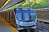
Union is a subway station on Line 1 Yonge–University of the Toronto subway in Toronto, Ontario, Canada. It opened in 1954 as one of twelve original stations on the first phase of the Yonge line, the first rapid transit line in Canada. It was the southern terminus of the line until the opening of the University line in 1963, and is today the inflection point of the U-shaped line. Along with Spadina station and Queens Quay station, it is one of three stations open overnight to support late-night streetcar routes.

The Eglinton West line was a proposed east–west subway line in Toronto, Ontario, Canada, whose construction began in 1994 but was cancelled in 1995. It was to start from the existing Eglinton West station on the Toronto Transit Commission's Yonge–University–Spadina line, travel underneath Eglinton Avenue West, and terminate at Black Creek Drive in its initial phase.

<span class="mw-page-title-main">Lake Shore Boulevard</span> Street in Toronto

Lake Shore Boulevard is a major arterial road running along more than half of the Lake Ontario waterfront in the city of Toronto, Ontario, Canada. Prior to 1998, two segments of Lake Shore Boulevard were designated as part of Highway 2, with the highway following the Gardiner Expressway between these two sections.

<span class="mw-page-title-main">The Queensway</span> Road in Toronto and Mississauga in Ontario, Canada

The Queensway is a major street in the municipalities of Toronto and Mississauga, Ontario, Canada. It is a western continuation of Queen Street, after it crosses Roncesvalles Avenue and King Street in Toronto. The Queensway is a divided roadway from Roncevalles westerly until 600 metres of the South Kingsway with its centre median dedicated to streetcar service. The road continues undivided west from there to Etobicoke Creek as a four- or six-lane thoroughfare.

The Queen Street subway line was a proposed subway line for the city of Toronto, Ontario, Canada. It was one of many subway lines planned for, but has yet to be built by the Toronto Transit Commission.

<span class="mw-page-title-main">Toronto streetcar system</span> Streetcar network in Ontario, Canada

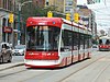
The Toronto streetcar system is a network of eleven streetcar routes in Toronto, Ontario, Canada, operated by the Toronto Transit Commission (TTC). It is the third busiest light-rail system in North America. The network is concentrated primarily in Downtown Toronto and in proximity to the city's waterfront. Much of the streetcar route network dates from the 19th century. Three streetcar routes operate in their own right-of-way, one in a partial right-of-way, and six operate on street trackage shared with vehicular traffic with streetcars stopping on demand at frequent stops like buses. Since 2019, the network has used low-floor streetcars, making it fully accessible.

<span class="mw-page-title-main">509 Harbourfront</span> Streetcar route in Toronto, Canada

509 Harbourfront is a Toronto streetcar route in Ontario, Canada, operated by the Toronto Transit Commission and connecting Union Station with Exhibition Loop.

<span class="mw-page-title-main">501 Queen</span> Streetcar route in Toronto, Canada

501 Queen is an east–west Toronto streetcar route in Ontario, Canada, operated by the Toronto Transit Commission (TTC). It stretches from Neville Park Loop in the east, running along Queen Street and in a reserved right-of-way within the median of the Queensway to Humber Loop in the west. In the late evenings, the 501 Queen route is extended west from Humber Loop, running on Lake Shore Boulevard to Long Branch Loop, replacing route 507 Long Branch. This route operates as part of the TTC's Blue Night Network service, operating in the early morning hours as the 301 Queen.

<span class="mw-page-title-main">504 King</span> Streetcar route in Toronto, Canada

504 King is an east–west Toronto streetcar route in Ontario, Canada. It serves King Street in Downtown Toronto as well as Broadview Avenue on the east end and Roncesvalles Avenue on the west end of the line. The route consists of two overlapping branches: 504A between Line 2 Bloor–Danforth's Dundas West station and Distillery Loop, and 504B between Broadview station – also on Line 2 – and Dufferin Gate Loop. The two branches overlap on King Street between Dufferin and Sumach streets, both passing St. Andrew station and King station on subway Line 1 Yonge–University.

<span class="mw-page-title-main">508 Lake Shore</span> Streetcar route in Toronto, Canada

The 508 Lake Shore is an east–west streetcar route in Toronto, Ontario, Canada, operated by the Toronto Transit Commission (TTC). The route serves the downtown financial district from the western limit of the city, and operated as a weekday rush hour service only. The route was started as an experiment in 1992, suspended in June 2015 due to a streetcar shortage, and reintroduced in September 2019. It was suspended again on March 24, 2020, due to low ridership during the COVID-19 pandemic. Effective October 30, 2023, 508 Lake Shore service resumed after completion of infrastructure work west of Roncesvalles Avenue.

<span class="mw-page-title-main">Exhibition Loop</span> Toronto Transit Commission streetcar terminus

Exhibition Loop is the terminus for the 509 Harbourfront and 511 Bathurst streetcar routes, the 174 Ontario Place-Exhibition, and the 307 Blue Night Bathurst bus routes. Exhibition Loop serves Exhibition Place, Coca-Cola Coliseum, BMO Field and connects with GO Transit at the Exhibition GO Station.

<span class="mw-page-title-main">Toronto and Mimico Electric Railway and Light Company</span> Former operator of the Mimico radial line in Toronto

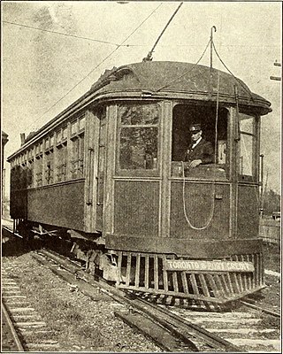
The Toronto and Mimico Electric Railway and Light Company was incorporated in 1890, and operated the Mimico radial line in the Toronto area. The line started operation in 1892 as a short suburban line that later was extended to Port Credit. In 1904, the railway was acquired by the Toronto and York Radial Railway (T&YRR) and became the T&YRR Mimico Division. In 1922, the City of Toronto acquired the T&YRR and contracted Ontario Hydro to manage the four T&YRR lines including the Mimico line. In 1927, the TTC took over the operation of the Mimico line and extended its service eastward to Roncesvalles Avenue. In 1928, the TTC double-tracked the line from Humber to Long Branch and made that portion part of the Lake Shore streetcar line. The portion beyond Long Branch to Port Credit became the Port Credit line, and continued operation as a single-track radial line until its closure on February 9, 1935.

<span class="mw-page-title-main">The Queensway–Humber Bay</span> Neighbourhood in Toronto, Ontario, Canada

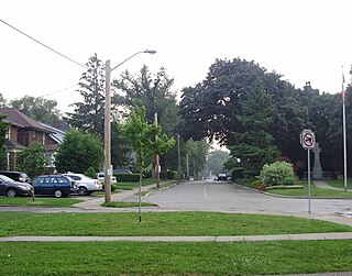
The Queensway–Humber Bay, known officially as Stonegate–Queensway, is a neighbourhood in the southwest of Toronto, Ontario, Canada. It is located in the southeast area of the former City of Etobicoke.

<span class="mw-page-title-main">Transit City</span> Proposed Toronto public transit plan

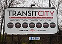
Transit City was a plan for developing public transport in Toronto, Ontario, Canada. It was first proposed and announced on 16 March 2007 by Toronto mayor David Miller and Toronto Transit Commission (TTC) chair Adam Giambrone. The plan called for the construction of seven new light rail lines along the streets of seven priority transit corridors, which would have eventually been integrated with existing rapid transit, streetcar, and bus routes. Other transit improvements outlined in the plan included upgrading and extending the Scarborough RT line, implementing new bus rapid transit lines, and improving frequency and timing of 21 key bus routes. The plan integrated public transportation objectives outlined in the City of Toronto Official Plan, the TTC Ridership Growth Strategy and Miller's 2006 election platform.

<span class="mw-page-title-main">Toronto streetcar system loops</span>

Turning loops of the Toronto streetcar system serve as termini and turnback points for streetcar routes in Toronto, Ontario, Canada. The single-ended streetcars require track loops in order to reverse direction. Besides short off-street track loops these can also be larger interchange points, having shelters and driver facilities, or be part of a subway station structure for convenient passenger interchange.

<span class="mw-page-title-main">Humber Loop</span> Toronto Transit Commission streetcar station

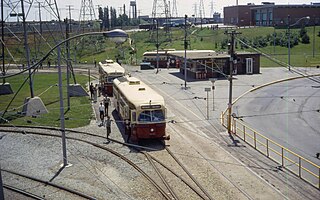
Humber Loop is a multimodal transit station and a hub for streetcar routes. It consists of two streetcar turning loops and one bus loop. Humber Loop is located between the Gardiner Expressway and the Queensway just west of the Humber River in Toronto. The loop is accessed by a private right-of-way along the Queensway on the east side of the loop and by Lake Shore Boulevard on its west side. As of November 19, 2023, four Toronto Transit Commission (TTC) streetcar routes either pass through or terminate at Humber Loop.

<span class="mw-page-title-main">Dufferin Gate Loop</span> Bus station and streetcar turning loop in Toronto, Ontario, Canada

Dufferin Gate Loop, also known as Dufferin Loop, is a Toronto Transit Commission (TTC) bus station and turning loop for streetcars near the southern end of Dufferin Street in Toronto, Ontario, Canada. During the Canadian National Exhibition (CNE), the loop becomes a primary access point for visitors entering Exhibition Place via the Dufferin Gates. This west entrance to the CNE can be reached by the Dufferin Street bridges across the Lakeshore West railway corridor and Gardiner Expressway.

East Bayfront LRT, also known as the Waterfront East LRT, is a planned Toronto streetcar line that would serve the East Bayfront and Port Lands areas in Toronto, Ontario, Canada. It would run from Union station under Bay Street and along Queens Quay and Cherry Street to a new Villiers Loop along Commissioners Street east of Cherry Street on Villiers Island. It would complement the existing 509 Harbourfront service that connects Union Station to Queens Quay west of Bay Street. Longer-term plans are to extend the East Bayfront line from Cherry and Commissioners Streets to the planned East Harbour Transit Hub along GO Transit's Lakeshore East line and the planned Ontario Line.

<span class="mw-page-title-main">Long Branch Loop</span> Streetcar loop in Toronto, Canada

Long Branch Loop is the westernmost streetcar stop within the Toronto streetcar system, operated by the Toronto Transit Commission (TTC). It is located in the Long Branch neighbourhood in southwestern Toronto, close to the boundary with Mississauga. Long Branch Loop is the western terminus for four streetcar routes but is principally served by the 507 Long Branch route. Several TTC and MiWay bus routes terminate at the loop.

References

  1. 1 2 3 4 5 6 7 "Waterfront Transit Update" (PDF). Toronto Transit Commission. November 13, 2017. Archived from the original (PDF) on November 26, 2019. Retrieved November 13, 2017.
  2. 1 2 Carter, Tristan (February 25, 2011). "Jane LRT goes off the rails". Town Crier. Streeter Publications. Archived from the original on September 5, 2017. Retrieved November 10, 2015.
  3. 1 2 D'Cruz, Andrew (December 1, 2010). "Mayor Rob Ford: "Transit City is over"". Toronto Life .
  4. 1 2 "Toronto's Transit Expansion Program - Update and Next Steps" (PDF). City of Toronto. April 3, 2019. Retrieved May 7, 2019.
  5. "The Big Move". Metrolinx. 2008. Retrieved April 22, 2015.
  6. Shepard, Tamara (January 10, 2013). "Residents share wishlist for Toronto budget". InsideToronto.com. Retrieved January 11, 2018.
  7. 1 2 "Waterfront Transit "Reset"" (PDF). City of Toronto. October 9, 2015. Retrieved November 6, 2015.
  8. 1 2 3 "Waterfront West LRT Connection to Union Station". Toronto: City Of Toronto. Toronto Transit Commission. 2008.{{cite journal}}: Cite journal requires |journal= (help)
  9. Toronto Transit Commission, Engineering Department (April 10, 2019). "Waterfront Transit Streetcar Connection: Exhibition Loop – Dufferin Gates Loop" (PDF). City of Toronto . Retrieved May 7, 2019.
  10. "Transit Expansion Program – Status Update" (PDF). 2019. Retrieved June 8, 2024.