Watson, New York

Last updated

Watson, New York
USA New York location map.svg
Red pog.svg
Watson
Usa edcp location map.svg
Red pog.svg
Watson
Coordinates: 43°48′16″N75°17′30″W / 43.80444°N 75.29167°W / 43.80444; -75.29167
Country United States
State New York
County Lewis
Area
[1]
  Total115.70 sq mi (299.65 km2)
  Land112.74 sq mi (291.99 km2)
  Water2.96 sq mi (7.67 km2)
Elevation
1,280 ft (390 m)
Population
 (2010)
  Total1,881
  Estimate 
(2016) [2]
1,849
  Density16.40/sq mi (6.33/km2)
Time zone UTC-5 (Eastern (EST))
  Summer (DST) UTC-4 (EDT)
ZIP code
13367
Area code 315
FIPS code 36-049-78729
GNIS feature ID979607 [3]
Website townofwatsonny.com

Watson is a town in Lewis County, New York, United States. The population was 1,881 at the 2010 census. [4] The town is named after early landowner James Watson. The town is at the eastern border of the county and is east of Lowville, the county seat.

Contents

History

The area of Watson was first settled circa 1815. The town was formed from the town of Leyden in 1821. Parts of Watson were later taken to form the towns of Greig (1828), Diana (1830), Croghan (1841) and New Bremen (1848).

Geography

According to the United States Census Bureau, the town has a total area of 115.7 square miles (300 km2), of which 112.7 square miles (292 km2) are land and 3.0 square miles (7.8 km2), or 2.56%, are water. [5]

The eastern town line is the border of Herkimer County, and the western town line is partly defined by the Black River.

The Beaver River, a tributary of the Black River, flows through the northern part of the town. The eastern section of Watson is inside the Adirondack Park.

Demographics

Historical population
CensusPop.Note
1830 909
1840 1,70787.8%
1850 1,138−33.3%
1860 1,028−9.7%
1870 1,14611.5%
1880 1,47028.3%
1890 1,299−11.6%
1900 981−24.5%
1910 757−22.8%
1920 707−6.6%
1930 528−25.3%
1940 5361.5%
1950 5869.3%
1960 78133.3%
1970 1,07237.3%
1980 1,27218.7%
1990 1,61326.8%
2000 1,98623.1%
2010 1,881−5.3%
2016 (est.)1,849 [2] −1.7%
U.S. Decennial Census [6]

As of the census [7] of 2000, there were 1,987 people, 772 households, and 562 families residing in the town. The population density was 17.6 people per square mile (6.8/km2). There were 1,652 housing units at an average density of 14.7 per square mile (5.7/km2). The racial makeup of the town was 98.49% White, 0.40% African American, 0.20% Native American, 0.10% Asian, 0.40% Pacific Islander, and 0.40% from two or more races. Hispanic or Latino of any race were 0.50% of the population.

There were 772 households, out of which 33.9% had children under the age of 18 living with them, 60.4% were married couples living together, 6.3% had a female householder with no husband present, and 27.2% were non-families. 21.4% of all households were made up of individuals, and 8.9% had someone living alone who was 65 years of age or older. The average household size was 2.57 and the average family size was 2.96.

In the town, the population was spread out, with 25.6% under the age of 18, 7.2% from 18 to 24, 29.7% from 25 to 44, 23.2% from 45 to 64, and 14.2% who were 65 years of age or older. The median age was 38 years. For every 100 females, there were 106.3 males. For every 100 females age 18 and over, there were 108.9 males.

The median income for a household in the town was $35,000, and the median income for a family was $38,438. Males had a median income of $28,208 versus $20,913 for females. The per capita income for the town was $15,708. About 8.0% of families and 11.3% of the population were below the poverty line, including 13.5% of those under age 18 and 14.2% of those age 65 or over.

Communities and locations in Watson

Related Research Articles

<span class="mw-page-title-main">Stratford, New York</span> Town in New York, United States

Stratford is a town in Fulton County, New York, United States. The population was 610 at the 2010 census. The town is in the northwestern corner of the county, northeast of the village of Dolgeville. It was named after Stratford, Connecticut.

<span class="mw-page-title-main">Morehouse, New York</span> Town in New York, United States

Morehouse is a town in Hamilton County, New York, United States. The population was 92 at the 2020 census. The name is that of an early developer, Andrew K. Morehouse.

<span class="mw-page-title-main">Columbia, New York</span> Town in New York, United States

Columbia is a town in Herkimer County, New York, United States. As of the 2020 census, the town population was 1,569. The town is at the southern border of the county and is southeast of Utica.

<span class="mw-page-title-main">Danube, New York</span> Town in New York, United States

Danube is a town in Herkimer County, New York, United States. The population was 801 at the 2020 census, down from 1,039 in 2010. Early Palatine German immigrants in the eighteenth century named the town after the Danube River in Europe.

<span class="mw-page-title-main">Litchfield, New York</span> Town in New York, United States

Litchfield is a town in Herkimer County, New York, United States. The population was 1,513 at the 2010 census. The town is named after Litchfield, Connecticut, the source of some early settlers of the city.

<span class="mw-page-title-main">Manheim, New York</span> Town in New York, United States

Manheim is a town in Herkimer County, New York, United States. The population was 3,334 at the 2010 census. The town name is derived from Mannheim in Baden, Germany.

<span class="mw-page-title-main">Ohio, New York</span> Town in New York, United States

Ohio is a town in Herkimer County, New York, United States. The population was 1,002 at the 2010 census. The town is named after the state of Ohio. The town is in the northern part of the county and northeast of Utica. Part of Ohio is within the Adirondack Park.

<span class="mw-page-title-main">Salisbury, Herkimer County, New York</span> Town in New York, United States

Salisbury is a town in Herkimer County, New York, United States. The population was 1,958 at the 2010 census. The town is on the eastern edge of the county, north of the city of Little Falls. The northern part of the town is in the Adirondack Park.

<span class="mw-page-title-main">Schuyler, New York</span> Town in Herkimer County, New York, US

Schuyler is a town in Herkimer County, New York, United States. The population was 3,420 at the 2010 census. The town is in the western part of Herkimer County and is east of Utica.

<span class="mw-page-title-main">Warren, New York</span> Town in Herkimer County, New York, US

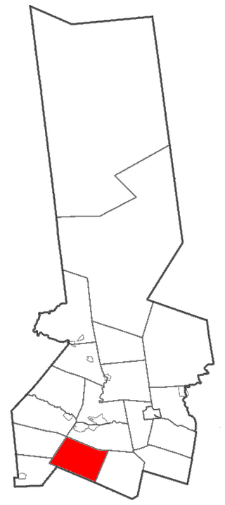
Warren is a town in Herkimer County, New York, United States. The population was 1,143 at the 2010 census. The town is named after General Joseph Warren, who was killed at the Battle of Bunker Hill. Warren is in the south part of Herkimer County. US 20 passes across the town.

<span class="mw-page-title-main">Webb, New York</span> Town in New York, United States

Webb is the northernmost town in Herkimer County, New York, United States. As of the 2010 census it had a population of 1,807.

<span class="mw-page-title-main">Winfield (town), New York</span> Town in New York, United States

Winfield is a town in Herkimer County, New York, United States. The population was 2,086 at the 2010 census. The town is named after General Winfield Scott and is in the southwestern corner of the county, south of Utica.

Diana is a town in Lewis County, New York, United States. The population was 1,709 at the 2010 census. The town is on the northeastern border of the county and is located northeast of Watertown. The northwestern section of Diana is in the Fort Drum military reservation.

Greig is a town in Lewis County, New York, United States, named after Congressman John Greig. The town was founded in 1828 from land taken from the town of Watson. Originally named "Brantingham", the town changed to its present name in 1832. Brantingham still survives as a hamlet within the boundaries of Greig, as a postal identity and for Brantingham Lake, to the east of town. As of the 2010 census, the population of Greig was 1,199.

New Bremen is a town in Lewis County, New York, United States. The population was 2,706 at the 2010 census. The town is named after the German city of Bremen.

<span class="mw-page-title-main">Forestport, New York</span> Town in New York, United States

Forestport is a town in Oneida County, New York, United States. The population was 1,477 at the 2020 census.

<span class="mw-page-title-main">Herkimer, New York</span> Town in New York, United States

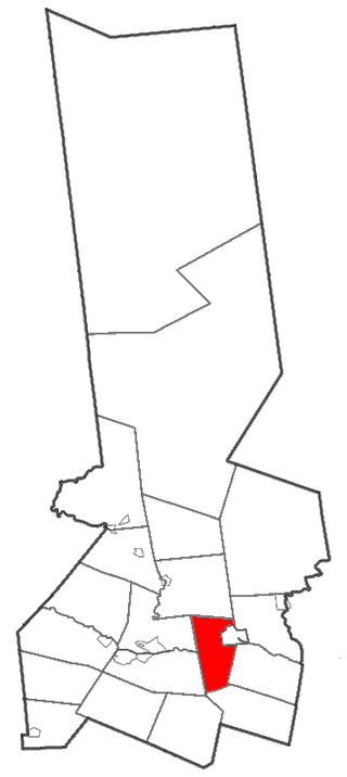
Herkimer is a town in Herkimer County, New York, United States, southeast of Utica. It is named after Nicholas Herkimer. The population was 9,566 at the 2020 census, down from 10,175 in 2010.

<span class="mw-page-title-main">Little Falls (town), New York</span> Town in New York, United States

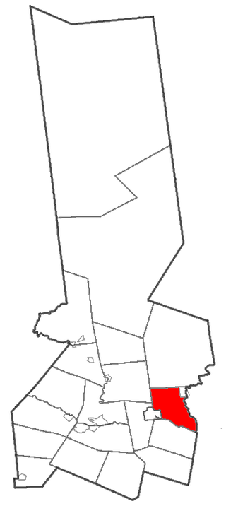
Little Falls is a town in Herkimer County, New York, United States. The population was 1,587 at the 2010 census. The town is named after falls and rapids on the Mohawk River nearby.

<span class="mw-page-title-main">Newport, New York</span> Town in New York, United States

Newport is a town in Herkimer County, New York, United States. The population was 2,302 at the 2010 census. The town, located on the western edge of the county, contains the village of Newport. The town is northeast of Utica.

<span class="mw-page-title-main">Croghan, New York</span> Town in New York, United States

Croghan is a town in Lewis County, New York, United States. The population was 3,093 at the 2010 census. The town is in the northern part of the county and located northeast of the county seat, Lowville. The town contains a village also named Croghan, a small part of which is located in the adjacent town of New Bremen. Both the village and town are locally pronounced \Krō-gun\.

References

  1. "2016 U.S. Gazetteer Files". United States Census Bureau. Retrieved July 5, 2017.
  2. 1 2 "Population and Housing Unit Estimates" . Retrieved June 9, 2017.
  3. U.S. Geological Survey Geographic Names Information System: Watson, New York
  4. "Total Population: 2010 Census DEC Summary File 1 (P1), Watson town, New York". data.census.gov. U.S. Census Bureau. Retrieved May 28, 2020.
  5. "U.S. Gazetteer Files: 2019: Places: New York". U.S. Census Bureau Geography Division. Retrieved May 28, 2020.
  6. "Census of Population and Housing". Census.gov. Retrieved June 4, 2015.
  7. "U.S. Census website". United States Census Bureau . Retrieved January 31, 2008.
  8. "National Register of Historic Places". WEEKLY LIST OF ACTIONS TAKEN ON PROPERTIES: 8/17/09 THROUGH 8/21/09. National Park Service. August 28, 2009.

43°46′33″N75°26′10″W / 43.77583°N 75.43611°W / 43.77583; -75.43611