
Waveney was a local government district in Suffolk, England, named after the River Waveney that formed its north-east border. The district council was based in Lowestoft, the major settlement in Waveney. The other towns in the district were Beccles, Bungay, Halesworth and Southwold.

South Norfolk is a local government district in Norfolk, England. The largest town is Wymondham, and the district also includes the towns of Costessey, Diss, Harleston, Hingham, Loddon and Long Stratton. The council was based in Long Stratton until 2023 when it moved to the Broadland Business Park near Norwich, in the neighbouring Broadland district, as part of a shared facility with Broadland District Council. Some of the district's urban areas form part of the Norwich built-up area. The district also includes numerous villages and surrounding rural areas. Some eastern parts of the district lie within The Broads.

Central Suffolk and North Ipswich is a constituency represented in the House of Commons of the UK Parliament since 2010 by Dan Poulter, who was elected as a Conservative but announced his defection to Labour in April 2024.

Bury St Edmunds was a constituency in Suffolk represented in the House of Commons of the UK Parliament from 2015 to 2024 by Jo Churchill, a Conservative.

South Norfolk is a constituency represented in the House of Commons of the UK Parliament since 2001 by Richard Bacon, a Conservative.

Suffolk Coastal is a parliamentary constituency in the county of Suffolk, England which has been represented in the House of Commons of the UK Parliament since 2010 by Thérèse Coffey, a Conservative Member of Parliament. She served as Secretary of State for Environment, Food and Rural Affairs from October 2022 to November 2023.
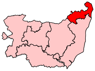
Waveney was a constituency represented in the House of Commons of the UK Parliament from 2010 to 2024 by Peter Aldous, a Conservative. It returned one Member of Parliament (MP) to the House of Commons of the Parliament of the United Kingdom.

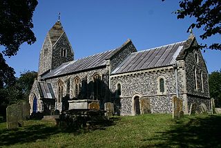
Homersfield, also known as St Mary, South Elmham, is a village and civil parish in the north of the English county of Suffolk. It is in the East Suffolk district, 4 miles (6.4 km) south-west of the market town of Bungay and 3 miles (4.8 km) north-east of Harleston. The official name of the civil parish is St Mary, South Elmham otherwise Homersfield. It is one of the parishes around Bungay known as The Saints.
The Saints are a group of villages in the north of the English county of Suffolk, between the rivers Blyth and Waveney near to the border with Norfolk. The villages are all named after a saint, and either South Elmham or Ilketshall named after the 'hall of Alfkethill'. Known by locals as 'up the Parishes' the area is found between the market towns of Halesworth, Harleston, Bungay and Beccles.

Wortwell is a village and civil parish in the English county of Norfolk and adjoining the county of Suffolk. It is located on both the River Waveney and the A143 road, some 20 km east of Diss and 30 km west of Lowestoft. The city of Norwich lies approximately 30 km to the north.

Lowestoft is a parliamentary constituency centred on the town of Lowestoft in Suffolk. It returns one Member of Parliament (MP) to the House of Commons of the Parliament of the United Kingdom, elected by the first past the post voting system.

The Waveney Valley line was a branch line running from Tivetshall in Norfolk to Beccles in Suffolk connecting the Great Eastern Main Line at Tivetshall with the East Suffolk line at Beccles. It provided services to Norwich, Great Yarmouth, Lowestoft, Ipswich and many other towns in Suffolk with additional services to London. It was named after the River Waveney which follows a similar route.

Suffolk was a constituency of the European Parliament located in the United Kingdom, electing one Member of the European Parliament by the first-past-the-post electoral system. Created in 1979 for the first elections to the European Parliament, it was abolished in 1994 and succeeded by the constituencies of Suffolk and South West Norfolk, Essex North and Suffolk South and Cambridgeshire.
Flixton is a village and civil parish located in the north of the English county of Suffolk. It is around 2 miles (3.2 km) south-west of Bungay in the East Suffolk district and is one of the villages around Bungay which make up the area known as The Saints. The A143 road runs just to the north of the parish border linking Bungay with Harleston and Diss.

The A144 is an A road in the English county of Suffolk. It runs from the town of Bungay, close to the border with Norfolk, to the A12 trunk road near the village of Darsham, passing through the market town of Halesworth. It is around 14 miles (23 km) in length and is single carriageway throughout.

East Suffolk is a local government district in Suffolk, England. The largest town is Lowestoft, which contains Ness Point, the easternmost point of the United Kingdom. The second largest town is Felixstowe, which has the country's largest container port. On the district's south-western edge it includes parts of the Ipswich built-up area. The rest of the district is largely rural, containing many towns and villages, including several seaside resorts. Its council is based in the village of Melton. The district was formed in 2019 as a merger of the two previous districts of Suffolk Coastal and Waveney. In 2021 it had a population of 246,058. It is the most populous district in the country not to be a unitary authority.

Bury St Edmunds and Stowmarket is a constituency of the House of Commons in the UK Parliament. Further to the completion of the 2023 Periodic Review of Westminster constituencies, it will first be contested at the 2024 general election. The constituency name refers to the Suffolk towns of Bury St Edmunds and Stowmarket.

