Weilheim in Oberbayern

Last updated

Weilheim in Oberbayern
Weilheim2.jpg
Pedestrian zone in Weilheim
DEU Weilheim in Oberbayern Flag.svg
DEU Weilheim in Oberbayern COA.svg
Location of Weilheim in Oberbayern within Weilheim-Schongau district
Weilheim in Oberbayern in WM.svgStarnberger SeeSchongauPremPollingOberhausenAltenstadt
Germany adm location map.svg
Red pog.svg
Weilheim in Oberbayern
Bavaria location map.svg
Red pog.svg
Weilheim in Oberbayern
Coordinates: 47°50′N11°09′E / 47.833°N 11.150°E / 47.833; 11.150
Country Germany
State Bavaria
Admin. region Upper Bavaria
District Weilheim-Schongau
Government
   Mayor (202026) Markus Loth [1]
Area
  Total55.44 km2 (21.41 sq mi)
Elevation
563 m (1,847 ft)
Population
 (2022-12-31) [2]
  Total23,056
  Density420/km2 (1,100/sq mi)
Time zone UTC+01:00 (CET)
  Summer (DST) UTC+02:00 (CEST)
Postal codes
82362
Dialling codes 0881
Vehicle registration WM
Website www.weilheim.de

Weilheim in Oberbayern (English: 'Weilheim in Upper Bavaria') is a town in Germany, the capital of the district Weilheim-Schongau in the south of Bavaria. Weilheim has an old city-wall, historic houses and a museum.

Contents

Local history

Up to the 18th century

The oldest traces of human settlement date back to the Bronze Age [3] and there were grave finds from the Late Roman era. [4] The name Weilheim is interpreted as a home to the Roman villas (land estates). There are, however, several other theories for the roots of the name. [5] Upper Bavaria came in Roman hands through commander Drusus. [6] The Romans built "Via Raetia" in 200 AD, which led over the Brenner Pass to Augsburg. [6] [7] This Roman road ran through the Weilheim area. [6] Around 476 AD, the Romans withdrew southwards and the Bavarians came into the region. [8]

The first documentary mention of the village "Wilhain" dates from 16 April 1010 of the king and later Emperor Heinrich II of Bamberg, who granted the monastery of Polling the property of a farm in Weilheim in 1010. [3] [9] From about 1080 onwards nobleman of Weilheim appeared, they were vassals from Andechs-Meranier and disappeared around 1312. [3] [10] From 1236, there was a palisade fence as a precursor to the town wall. [10] [11] Around 1328, the Munich patrician Ludwig Pütrich enabled the establishment of the Heiliggeistspital (lit.: Holy Spirit Hospital) outside the town walls through donations. [3] [12] An award of the town is named after him. In the Middle Ages, there were several big fires in Weilheim. When a plague epidemic broke out in Munich in 1521, the Bavarian dukes Wilhelm IV and Ludwig temporarily resided in Weilheim. [3] [13] Early in the 17th century, artwork flourished in Weilheim, especially the Weilheimer sculpture school. [14] Well-known representatives from this time were Georg Petel, Hans Krumpper, and Johann Sebastian Degler. In 1611, the so-called Trifthof was set up at the Ammer for log drifting, [3] [15] where tree trunks were bond together as rafts to carry them along the waterway down to the Amper. [3] [16] In 1639, the Franciscan monastery of St. Joseph was founded at the Schmied Gate because of a lack of priests . [17]

19th and 20th century

The Franciscan monastery in Weilheim was abolished as a result of the secularisation in 1802. [3] [18] 120 houses burnt down and two people were killed in a severe fire disaster in the Oberen Stadt (lit.: upper town) on 3 May 1810. [19] [20] The former Franciscan monastery burnt down in 1825, after which a Heiliggeistspital was built and a hospital on today's Münchner Straße in 1826. [3] [21] On 1 October 1869, the first daily newspaper was published, the "Weilheimer Tagblatt". [3] [18] Between 1872 and 1874, three city gates were demolished, the Obere Tor in 1872, the Schmied Gate in 1873, and the Pöltner Gate in 1874. [3] [22] 24 people were killed and the train station was destroyed by an air raid in the Second World War on 19 April 1945. [3] [23]

Sport

The aeroclub Weilheim-Peißenberg flying at Paterzell airfield is rather successful in glider aerobatics: 2006 German National Champion Markus Feyerabend [24] and Hans-Georg Resch [25] are members of the German national glider aerobatics team.

Transport

Weilheim has a station on the Munich-Garmisch-Partenkirchen railway.

Notable people

FC Bayern Munich and German national team footballer Thomas Muller in 2013. Thomas Muller 2703.jpg
FC Bayern Munich and German national team footballer Thomas Müller in 2013.

International relations

Weilheim in Oberbayern is twinned with:

Related Research Articles

<span class="mw-page-title-main">Friedrich Ludwig Georg von Raumer</span> German historian (1781–1873)

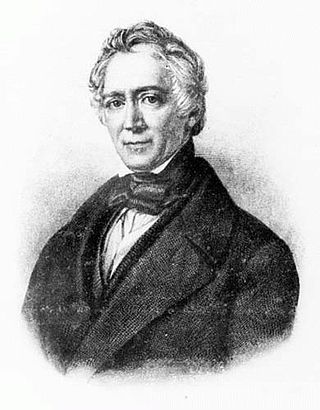
Friedrich Ludwig Georg von Raumer was a German historian. He was the first scientific historian to popularise history in German. He travelled extensively and served in German legislative bodies.

<span class="mw-page-title-main">Himmelpforten</span> Municipality in Lower Saxony, Germany

Himmelpforten is a municipality west of Hamburg (Germany) in the district of Stade in Lower Saxony. It is located on the Horsterbeck creek. Himmelpforten is also part and the seat of the Samtgemeinde Oldendorf-Himmelpforten.

<span class="mw-page-title-main">Schongau, Bavaria</span> Town in Bavaria, Germany

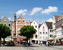
Schongau is a town in Bavaria, near the Alps. It is located along the Lech, between Landsberg am Lech and Füssen. It has about 12,000 inhabitants. Schongau has a well-preserved old wall around the center.

<span class="mw-page-title-main">Lüchow</span> Town in Lower Saxony, Germany

Lüchow (Wendland) is a city in northeastern Lower Saxony, in Germany. It is the seat of the Samtgemeinde Lüchow (Wendland), and is the capital of the district Lüchow-Dannenberg. Situated approximately 13 km north of Salzwedel, Lüchow is located on the German Framework Road. In the Polabian language, Lüchow is called Ljauchüw.

<span class="mw-page-title-main">Peißenberg</span> Municipality in Bavaria, Germany

Peißenberg is a municipality in the Weilheim-Schongau district, in Bavaria, Germany. It is situated 7 km southwest of Weilheim in Oberbayern.

<span class="mw-page-title-main">Weilheim an der Teck</span> Town in Baden-Württemberg, Germany

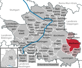
Weilheim an der Teck is a town in the district of Esslingen in Baden-Württemberg in southern Germany. It is situated 7 km southeast of Kirchheim unter Teck, and 13 km southwest of Göppingen. Locals often refer to it as just "Weilheim", although there are in fact several "Weilheims" in Germany including one other in Baden-Württemberg.

<span class="mw-page-title-main">Wessobrunn</span> Municipality in Bavaria, Germany

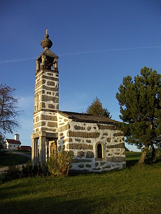
Wessobrunn is a municipality in the district of Weilheim-Schongau in Bavaria in Germany.

<span class="mw-page-title-main">Hohenpeißenberg</span> Municipality in Bavaria, Germany

Hohenpeißenberg is a municipality in the Weilheim-Schongau district, in Bavaria, Germany. Hohenpeißenberg is situated in the Bavarian Oberland, in the Alpine Foreland.

<span class="mw-page-title-main">Weiding, Schwandorf</span> Municipality in Bavaria, Germany

Weiding is a municipality in the district of Schwandorf in Bavaria, Germany.

<span class="mw-page-title-main">Weitersfelden</span> Place in Upper Austria, Austria

Weitersfelden is a municipality in the district of Freistadt in the Mühlviertel in the Austrian state of Upper Austria.

<span class="mw-page-title-main">Hans Stuhlmacher</span> German pedagogue, Wehrmacht officer, and local historian

Hans Albert Alexander Louis Carl Stuhlmacher (1892–1962) was a German pedagogue, Wehrmacht officer and local historian.

<span class="mw-page-title-main">Bundesstraße 23</span> Federal highway in Germany

The Bundesstraße 23 is a German federal highway in Bavaria that runs about 59.2 kilometres, from Peiting to the Austrian border near Garmisch-Partenkirchen. This highway (partially), along with the Bundesstraße 17 and Bundesstraße 472 highways, constitute the “German Alpine Road”. Coupled with the Bundesstraße 2 highway, it passes through cities such as Mittenwald, Innsbruck and the Brenner Pass.

<span class="mw-page-title-main">Weilheim (Oberbay) station</span>

Weilheim (Oberbay) station is the station of the Bavarian district town of Weilheim in Oberbayern. It is a crossing station on the Munich–Garmisch-Partenkirchen railway, the Ammersee Railway from Mering and the Weilheim–Peißenberg railway. It is classified by Deutsche Bahn as a category 4 station and has five platform tracks. It is served by about 100 trains daily operated by Deutsche Bahn and Bayerische Regiobahn (BRB).

<span class="mw-page-title-main">Michael Matheus</span> German historian (born 1953)

Michael Matheus is a German historian.

Himmelpforten Convent was founded as a monastery of nuns following the Cistercian Rule during the 13th century in Himmelpforten, in today's Lower Saxony, Germany. During the 16th century, it was converted into use as a Lutheran Damsels' Convent. The Himmelpforten Convent was founded before 1255 and finally dissolved in 1647. The convent complex was built between 1300 and 1330. After 1645 the buildings, including the abbey, increasingly decayed, until they were little by little demolished. The dilapidated abbey was demolished in 1737 and replaced by today's St. Mary's Church which partially covers the foundations of the former abbey.

The Brabant Road, Cologne to Leipzig Road or Liege Road is an ancient road which, during the Middle Ages and Early Modern Period, was one of the most important continental east-west oriented military and trade routes. It ran from the eponymous Duchy of Brabant to Leipzig.

<span class="mw-page-title-main">Klaus Mlynek</span> German scientific archivist and historian

Klaus Mlynek is a German historian and scientific archivist. The long-term director of the Stadtarchiv Hannover is one of the editors and authors of the Hannover City Lexicon , an encyclopedia of Hanover.

Waldemar R. Röhrbein was a German historian. He worked as a museum director in Lower Saxony, his last post being from 1976 to 1997 at the Historisches Museum Hannover, and was president of the Homeland Federation of Lower Sachsony. He contributed to encyclopedias about Hanover's history and culture.

<span class="mw-page-title-main">Mainz Charterhouse</span> Carthusian monastery in Mainz, Germany

Mainz Charterhouse is a former Carthusian monastery, or charterhouse, in Mainz, Rheinland-Pfalz, Germany, demolished in 1790–1792 but still marked by the street-name "Karthaus".

Hans Michael Finger was a German teacher and head of the district home office in Peine.

References

  1. Liste der ersten Bürgermeister/Oberbürgermeister in kreisangehörigen Gemeinden, Bayerisches Landesamt für Statistik, 15 July 2021.
  2. Genesis Online-Datenbank des Bayerischen Landesamtes für Statistik Tabelle 12411-003r Fortschreibung des Bevölkerungsstandes: Gemeinden, Stichtag (Einwohnerzahlen auf Grundlage des Zensus 2011)
  3. 1 2 3 4 5 6 7 8 9 10 11 12 Bernhard Wöll (Stadtarchiv Weilheim i. OB): Jubiläums-Chronik der Stadt Weilheim, anlässlich der 1000-jährigen erstmaligen urkundlichen Erwähnung im Jahr 1010 von Weilheim und Polling, Herausgeber: Stadt Weilheim i. OB 2010.
  4. Karl Schmotz: Bemerkungen zur frühen Geschichte Weilheims. In: Lech-Isar-Land 1980, p. 138
  5. Bernhard Wöll (Stadtarchiv Weilheim i. OB): Jubiläums-Chronik der Stadt Weilheim, anlässlich der 1000-jährigen erstmaligen urkundlichen Erwähnung im Jahr 1010 von Weilheim und Polling, Herausgeber: Stadt Weilheim i. OB 2010, in der Einleitung
  6. 1 2 3 Sonderbeilage des Weilheimer Tagblattes anlässlich der 1000-jährigen erstmaligen urkundlichen Erwähnung der Orte Polling und Weilheim 16 April 2010, page 4.
  7. Via Raetia, Websitebetreiber: Karl Ludwig Wilhelm, retrieved 2 October 2010.
  8. Geschichte. In: Der Landkreis Weilheim-Schongau. Herausgeber: Landratsamt Weilheim-Schongau 2010, Texte: Max Biller (Kreisarchivpfleger), Helmut Schmidbauer (Kreisheimatpfleger), Seite 8 f
  9. Theobald Wirth: Weilheimer Heimatbuch. Geschichte – Kunst und Wissenswertes aus der Stadt an der Ammer. Selbstverlag 1977, p. 18 f, mit deutscher Übersetzung des Textes dieser Urkunde aus dem Lateinischen.
  10. 1 2 Georg Paula, Stefanie Berg-Hobohm: Landkreis Weilheim-Schongau: Denkmäler in Bayern. Karl M. Lipp, München 2003, Band 2, p. 528
  11. Klaus Gast: Die Weilheimer Stadtmauer (Teil 1). In: Lech-Isar-Land 2016, S. 9–24
  12. Christian Buck (Hrsg.), Hans Rid: Aus Weilheims Vergangenheit. Entwicklungsgeschichte der Stadt Weilheim vom Mittelalter bis zum Beginn des 20. Jahrhunderts. Stöppel, Weilheim 1984, p. 29
  13. Christian Buck (Hrsg.), Hans Rid: Aus Weilheims Vergangenheit. Entwicklungsgeschichte der Stadt Weilheim vom Mittelalter bis zum Beginn des 20. Jahrhunderts. Stöppel, Weilheim 1984, p. 47 f.
  14. Vgl. Heinz-Jürgen Sauermost: Die Weilheimer – Große Künstler aus dem Zentrum des Pfaffenwinkels. Süddeutscher Verlag, München 1988.
  15. Weilheim Chronik: Frühe Neuzeit, retrieved: 29 October 2009.
  16. Flößerei und Holztrift. In: Georg Paula, Stefanie Berg-Hobohm: Landkreis Weilheim-Schongau: Denkmäler in Bayern. Karl M. Lipp, München 2003, Band 1, Seite XXIII
  17. Joachim Heberlein: Weil Priester fehten, kamen Mönche. In: Weilheimer Tagblatt, 23/24 October 2010, page 3, Lokales
  18. 1 2 Weilheim Chronik: Jüngere Geschichte, retrieved: 29 October 2009.
  19. Joachim Heberlein: Feuer vernichtet 120 Häuser. In: Weilheimer Tagblatt, 12/13 May 2010, p. 4, Lokales
  20. Theobald Wirth: Weilheimer Heimatbuch. Geschichte – Kunst und Wissenswertes aus der Stadt an der Ammer. 2. Auflage. Selbstverlag, 1978, p. 59
  21. Christian Buck (Hrsg.), Hans Rid: Aus Weilheims Vergangenheit. Entwicklungsgeschichte der Stadt Weilheim vom Mittelalter bis zum Beginn des 20. Jahrhunderts. Stöppel, Weilheim 1984, p. 133
  22. Christian Buck (Hrsg.), Hans Rid: Aus Weilheims Vergangenheit. Entwicklungsgeschichte der Stadt Weilheim vom Mittelalter bis zum Beginn des 20. Jahrhunderts. Stöppel, Weilheim 1984, Seite 211 ff
  23. Joachim Heberlein: Weilheims schwarzer Donnerstag kurz vor Kriegsende. In: Weilheimer Tagblatt, 19 April 2010, p. 3, Lokales
  24. DAeC: German National Team member Markus Feyerabend (in German) – accessed 2008-02-09
  25. DAeC: German National Team member Hans-Georg Resch (in German) – accessed 2008-02-09