West Bank areas in the Oslo II Accord

Last updated

Oslo II Accord map of Area A and B.jpg
Official 1995 agreement map of Areas A and B (with C being defined as the rest of the West Bank)
Oslo Areas and barrier projection 2005.png
2005 map showing areas A and B along with nature reserves and Israeli settlements. The red line is a projected route of the West Bank Barrier
Settlements2006.jpg
Map highlighting Area C where the access is closed and restricted to Palestinians. Darker areas are Israeli settlements and military posts within Area C.

The Oslo II Accord divided the Israeli-occupied West Bank into three administrative divisions: the Palestinian enclaves as "Areas A and B" and the remainder, including Israeli settlements, as "Area C".

Contents

The Palestinian enclaves were created by a process of subtraction by allocating to Area C everything that the Israeli government considered "important", thereby consigning the vast majority of West Bank Palestinians to the remaining non-contiguous areas. [1] [2]

Area C forms a contiguous territory on 61% of the West Bank, and is administered solely by Israel via the Judea and Samaria Area administration. As of 2015, it is home to 150,000 Palestinians [3] in 532 residential areas, and roughly 400,000 Israelis [4] in 135 settlements and more than 100 unrecognized outposts.

In contrast, Areas A and B are subdivided into 165 enclaves of land that have no territorial contiguity. [2] Area A is exclusively administered by the Palestinian National Authority; Area B is administered by both the Palestinian Authority and Israel. Area A comprises approximately 18% of the total territory of the West Bank and Area B about 22% of the territory, together home to some 2.8 million Palestinians. [5]

Divisions

The Oslo II Accord stipulated that "during the first phase of redeployment" the jurisdiction over Areas A and B would be transferred to the Palestinian Council. Article XI.2.a reads: "Land in populated areas (Areas A and B), including government and Al Waqf land, will come under the jurisdiction of the Council during the first phase of redeployment."

The populated areas were defined by delineations on a map attached to the document. Area C comprised the areas of the West Bank outside Areas A and B. [6]

Palestinian enclaves (Areas A and B)

Area A (full civil and security control by the Palestinian Authority): initially, circa 3% of the West Bank, exclusive East Jerusalem (first phase, 1995). [7] As of 2013, Area A formally comprised about 18% of the West Bank. [2] During the second intifada, the Israel Defense Forces abolished the prohibition against entering Area A during Operation Defensive Shield in 2002 and entered the area regularly, mostly at night, conducting raids to arrest suspected militants. [8] Typically, such raids are coordinated with the Palestinian security forces. [9] This area includes eight Palestinian cities and their surrounding areas (Nablus, Jenin, Tulkarem, Qalqilya, Ramallah, Bethlehem, Jericho and 80 percent of Hebron), with no Israeli settlements. [10] Entry into this area is forbidden to all Israeli citizens.

Area B (Palestinian civil control and joint Israeli-Palestinian security control): initially, circa 23–25% (first phase, 1995). [7] As of 2013, Area B formally comprised about 22% of the West Bank. [2] This area includes some 440 Palestinian villages and their surrounding lands, and no Israeli settlements. [10] It was defined in the accord as "the populated areas delineated by a red line and shaded in yellow on attached map No. 1, and the built-up area of the hamlets listed in Appendix 6 to Annex I"; this list of hamlets is as follows:

A. Tulkarm District

B. Nablus District

C. Salfit District

D. Jericho District

E. Qalqilya District

F. Jenin District

G. Hebron District

H. Ramallah District

I. Bethlehem District

1. Akkaba

2. Al Nazla Al Wusta

3. Koor

4. Kife

1. Jalood

2. Al-Juneid

3. Al-Aqrabinya

4. Nisf Jbeil

5. Yanoon

6. Iraq Bureen

7. A'mouria

Khirbat Qays

Al-Zubeidet

1. Seer

2. Khirbat Salman

3. Falamiya

4. Khirbat Ras Tera

5. Asalah

6. Al-Funduq

7. Al-Modawar

1. Toura Al-Gharbiyyah

2. Al-Zawiyyah

3. Mashrou' Beit Qad

4. Al Kafir

5. Al Mutla

6. Talfit

7. Toura-Al Sharqiyyah

1. Al Aziz

2. Khirbat Al-salam 3. Abu Al-A'sja 4. Sikka 5. Wadi Al-Shajna 6. Beit Marseem 7. Al-Hijra 8. Deir Razeh 9. Khilat Al-Mayat 10. Khilat Al A'qd 11. Um Lasafa 12. Qinan Jaber 13. Raboud 14. Shweik 15. Khirbat Skeik 16. Jroun Al-Louz 17. Beit Makdoum 18. Al-Mouriq 19. Al Beira 20. Al Juba 21. Beit I'mra 22. Turama 23. Hadb Al-Alaka 24. Deir Al-A'sal Al Tahta 25. Beit Al Roush Al-Tahata 26. Al-Deir 27. Kuezeiba 28. Hitta 29. Korza

1. Jibaa

2. Ein Qinya

3. Yabroud

4. Deir Nitham

5. Um Saffa

6. Burham

7. Al-Nabi Saleh

8. Shibteen

9. Khirbat Um Al-Lahm

10. Beit Ijza

1. Wadi Al-Neis

2. Mirah Rabah 3. Al Mas'ara 4. Um Salamouna 5. Al-Khas 6. Khilat Al-louz 7. Abu-Nijem 8. Beit Faloh 9. Breide'a 10. Khirbat Al-Deir 11. Daher Al-Nada 12. Al-Minshya 13. Khilat al-Hadad 14. Keisan 15. Al-Rashaida 16. Harmala 17. Mrah Mia'alla

Remainder of the West Bank (Area C), including Israeli settlements

Hebron Redeployment Map.jpg
Official 1997 agreement map of Palestinian controlled H1 and Israeli controlled H2.
Hebron redeployment 1997.jpg
Illustration showing areas H1 and H2 and adjacent Israeli settlements

Area C (full Israeli civil and security control): initially, circa 72–74% (first phase, 1995). [7] [11] Under the 1998 Wye River Memorandum, Israel would further withdraw from some additional 13% from Area C to Area B, which officially reduced Area C to circa 61% of the West Bank. [12] [13] Israel, however, withdrew from only 2%, [10] and during Operation Defensive Shield, it reoccupied all territory. As of 2013, Area C formally comprised about 63% of the West Bank, including settlements, outposts and declared "state land". [2] Including or excluding annexed East Jerusalem, no-man's land and the Palestinian part of the Dead Sea also determines the percentage. John Kerry, U.S. Secretary of State under the Obama administration, stated that Area C "is effectively restricted for any Palestinian development, and that few building permits had been granted to Palestinian residents of the area. [14]

All Israeli settlements (except those in East Jerusalem, which was annexed to Israel) are located in Area C. [10] [2] Oslo II, Article XII, for example, states: "For the purpose of this Agreement, 'the Settlements' means, in the West Bank the settlements in Area C; and in the Gaza Strip [which were later evacuated during the disengagement] ..." [6]

Settler population by year in the Israeli-occupied territories from 1972 to 2007 IsraeliSettlementGrowthLineGraph.png
Settler population by year in the Israeli-occupied territories from 1972 to 2007

In 1972, there were 1,000 Israeli settlers living in what is now Area C. By 1993, their population had increased to 110,000. [15] Over 400,000 Jewish settlers live in Area C in Israeli settlements and outposts. [16] Approximately 300,000 Palestinians live there as well; who reside in more than 500 households areas located partially or fully in Area C. [16]

Oslo definition of Area C

Oslo II defines Area C as follows:

"Area C" means areas of the West Bank outside Areas A and B, which, except for the issues that will be negotiated in the permanent status negotiations, will be gradually transferred to Palestinian jurisdiction in accordance with this Agreement.

The issues that will be negotiated, according to Article XVII, are "Jerusalem, settlements, specified military locations, Palestinian refugees, borders, foreign relations and Israelis; and … powers and responsibilities not transferred to the Council". [6] Parts of Area C are military area closed for Palestinians.

Transfer of Area C

Part of Area C was intended to be handed to Palestinians by the end of 1999. [17] Israel promised to redeploy its troops from Areas A and B before the elections. After the inauguration of an elected Palestinian parliament, the Israeli Civil Administration would be dissolved and the Israeli military government be withdrawn. The Council would get some powers and responsibilities. [18]

Within 18 months from the date of inauguration, Israel would further redeploy military forces from Area C in three phases, however, without transfer of any sovereignty to the Palestinians:

The Council will assume powers and responsibilities for civil affairs, as well as for public order and internal security, according to this Agreement. [18]

1. Israel shall transfer powers and responsibilities as specified in this Agreement from the Israeli military government and its Civil Administration to the Council in accordance with this Agreement. Israel shall continue to exercise powers and responsibilities not so transferred.

5. After the inauguration of the Council, the Civil Administration in the West Bank will be dissolved, and the Israeli military government shall be withdrawn. The withdrawal of the military government shall not prevent it from exercising the powers and responsibilities not transferred to the Council. [6]

The military forces would be redeployed in "specified military locations" in the West Bank, to be negotiated in the permanent status negotiations within 18 months. [18] The Legislative Council was elected in January 1996.

Use of Area C

OCHAoPt map of Area C. More than 99% of Area C is heavily restricted or off-limits to Palestinian development, with 68% reserved for Israeli settlements, approximately 21% for closed military zones, and about 9% for nature reserves. Construction permits for residential or economic purposes are, according to World Bank, "virtually impossible" for Palestinians to obtain. Restricted space in the West Bank, Area C.png
OCHAoPt map of Area C. More than 99% of Area C is heavily restricted or off-limits to Palestinian development, with 68% reserved for Israeli settlements, approximately 21% for closed military zones, and about 9% for nature reserves. Construction permits for residential or economic purposes are, according to World Bank, "virtually impossible" for Palestinians to obtain.

Area C, 99% of which is excluded from Palestinian use, contains most of the West Bank's natural resources and open spaces, access to which, according to the World Bank, would enable the Palestinians to halve their budget deficit and lead to an expansion of their economy by a third. [20] [19] According to Danny Rubinstein: "Much land in Area C is undeveloped. Israel, however, does not permit Palestinian construction for residential, commercial or industrial purposes." [21]

70 percent of the area is defined as within settler municipal boundaries, where permits for development are denied to Palestinians. The World Bank estimates that the effect has been to cause a potential loss of $14 billion of revenue for the Palestinian economy. [21]

According to a 2013 EU report, Israeli policies have undermined the Palestinian presence in Area C, with a deterioration in basic services such as water supplies, education and shelter. Nearly 70% of the Palestinian villages are not connected to the water network that serves settlers, which accounts for the fact that Palestinians in the zone use only a quarter to a third of the pro capita consumption of settlers. [22]

Palestinians cannot build in Area C without an army permit; however, building applications are expensive and have a 5% approval rate. As a result, most Palestinians who build there do so illegally. Israel demolishes about 200 buildings per year in Area C. [23]

Israel has made over 14,000 demolition orders against Palestinian-owned structures in Area C since 1988. [24] As of January 2015, almost 20% of the demolition orders issued had been executed and more than 11,000 of these still outstanding, affecting an estimated 17,000 structures. [25]

Israeli planning in Area C allocates 13 times more space to Israeli settlers than to Palestinians there, according to the United Nations. Israeli settlers have been allocated about 790 square meters per capita, whereas Palestinians have been allocated about 60 square meters per capita. [24]

During the period 1988–2014, the Israeli Civil Administration issued 6,948 demolition orders against structures in settlements located in Area C. As of January 2015, 12% of these were classified as executed, 2% were cancelled, another 2% "ready for execution" and 2% on hold due to legal proceedings. More than one-third of the orders were classified as "in process", while the current status of about 45% of the demolition orders against settlement structures was unknown. [25]

Alleged violation of the Accords

Israeli signpost warning Israeli citizens that entry into Area 'A' is forbidden, life-endangering, and constitutes a criminal offense Area A.JPG
Israeli signpost warning Israeli citizens that entry into Area 'A' is forbidden, life-endangering, and constitutes a criminal offense

The relatively new phenomenon of building Palestinian settlements began in 2006, attempting to trace after the Israeli settlement experience beyond the 1967 Green Line, and in a media-driven counter-offensive. [26] The most notable Palestinian settlement in the West Bank, defined by Israel as "illegal", was built in January 2013 on E1 Area East of Jerusalem. The settlement which was named "Bab al-Shams" consisted of about 20 tents, constructed by the Popular Struggle Co-ordination Committee. [27] A few days after the evacuation, another "Palestinian settlement" was erected in the village of Beit Iksa near the planned Wall barrier, which they claim would confiscate Palestinian land. It was named "Bab al-Karama". [28] [29]

Area B is defined as land under Palestinian civil control and Israeli military control. According to Dror Etkes, Israeli settlers have violated the accords by spreading into Area B and seizing private Palestinian land for cultivation and settlement. Examples he cites are the Amona settlement, overlooking Ofra, where he argues that land belonging to villagers of Deir Dibwan has been taken for redevelopment; the settlement of Itamar which he says has seized control of land and resources belonging to the Area B villages of Yanun, Awarta and Einabus; he states that settlers have seized Area B land near Esh Kodesh and Mitzpeh Ahiya east of Shilo; and he states that settlers of Ma'ale Rehav'am have built in a nature reserve established under the Wye River Memorandum. [30]

Religious sites

Responsibility for religious sites in the West Bank and Gaza Strip was to be transferred to the Palestinian side, gradually in the case of Area C. [31] [32] The Palestinian side agreed to ensure free access to a specific list of Jewish religious sites [33] but due to the uncertain security situation the Israel Defense Forces limits visits by Jews to rare occasions. [34] In Area C, Nabi Musa was to be under the auspices of the Palestinian side and access to al-Maghtas on the Jordan River was promised for particular religious events. [32]

See also

Related Research Articles

<span class="mw-page-title-main">Israeli settlement</span> Israeli communities built on land occupied in the 1967 Six-Day War

Israeli settlements, also called Israeli colonies, are the civilian communities built by Israel throughout the Israeli-occupied territories. They are populated by Israeli citizens, almost exclusively of Jewish identity or ethnicity, and were first established after Israel's victory in the Six-Day War of June 1967. The international community considers Israeli settlements to be illegal under international law, but Israel disputes this. The expansion of settlements often involves the confiscation of Palestinian land and resources, leading to displacement of Palestinian communities and creating a source of tension and conflict. Settlements are often protected by the Israeli military and are frequently flashpoints for violence against Palestinians. Further, the presence of settlements and Jewish-only bypass roads creates a fragmented Palestinian territory, seriously hindering economic development and freedom of movement for Palestinians.

<span class="mw-page-title-main">West Bank</span> Territory in West Asia

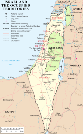
The West Bank, so called due to its relation to the Jordan River, is the larger of the two Palestinian territories. A landlocked territory near the coast of the Mediterranean Sea in the Levant region of West Asia, it is bordered by Jordan and the Dead Sea to the east and by Israel to the south, west, and north. The territory has been under Israeli occupation since 1967.

<span class="mw-page-title-main">Israeli–Palestinian conflict</span> Ongoing military and political conflict in the Levant

The Israeli–Palestinian conflict is an ongoing military and political conflict about self-determination within the territory of the former Mandatory Palestine. Key aspects of the conflict include the Israeli occupation of the West Bank and Gaza Strip, the status of Jerusalem, Israeli settlements, borders, security, water rights, Palestinian freedom of movement, and the Palestinian right of return.

<span class="mw-page-title-main">Oslo I Accord</span> 1993 Israel–Palestine Liberation Organization agreement

The Oslo I Accord or Oslo I, officially called the Declaration of Principles on Interim Self-Government Arrangements or short Declaration of Principles (DOP), was an attempt in 1993 to set up a framework that would lead to the resolution of the ongoing Israeli–Palestinian conflict. It was the first face-to-face agreement between the government of Israel and the Palestine Liberation Organization (PLO).

<span class="mw-page-title-main">Palestinian territories</span> Occupied Palestinian territory in the Middle East

The Palestinian territories are the two regions of the former British Mandate for Palestine that have been occupied by Israel since the Six-Day War of 1967, namely the West Bank and the Gaza Strip. The International Court of Justice (ICJ) has referred to the West Bank, including East Jerusalem, as "the Occupied Palestinian Territory", and this term was used as the legal definition by the ICJ in its advisory opinion of July 2004. The term occupied Palestinian territory was used by the United Nations and other international organizations between October 1999 and December 2012 to refer to areas controlled by the Palestinian National Authority, but from 2012, when Palestine was admitted as one of its non-member observer states, the United Nations started using exclusively the name State of Palestine. The European Union (EU) also uses the term "occupied Palestinian territory". The government of Israel and its supporters use the label "disputed territories" instead.

<span class="mw-page-title-main">Oslo II Accord</span> 1995 agreement in the Israeli–Palestinian peace process

The Interim Agreement on the West Bank and the Gaza Strip commonly known as Oslo II or Oslo 2, was a key and complex agreement in the Israeli–Palestinian peace process. Because it was signed in Taba, Egypt, it is sometimes called the Taba Agreement. The Oslo Accords envisioned the establishment of a Palestinian interim self-government in the Palestinian territories. Oslo II created the Areas A, B and C in the West Bank. The Palestinian Authority was given some limited powers and responsibilities in the Areas A and B and a prospect of negotiations on a final settlement based on Security Council Resolutions 242 and 338. The Accord was officially signed on 28 September 1995.

<span class="mw-page-title-main">Road map for peace</span> Proposal for a two-state solution in the Israeli–Palestinian peace process

The roadmap for peace or road map for peace was a plan to resolve the Israeli–Palestinian conflict proposed by the Quartet on the Middle East: the United States, the European Union, Russia and the United Nations. The principles of the plan, originally drafted by U.S. Foreign Service Officer Donald Blome, were first outlined by U.S. President George W. Bush in a speech on 24 June 2002, in which he called for an independent Palestinian state living side by side with Israel in peace. A draft version from the Bush administration was published as early as 14 November 2002. The final text was released on 30 April 2003. The process reached a deadlock early in phase I and the plan was never implemented.

<span class="mw-page-title-main">Wye River Memorandum</span> 1998 step in the Israel-Palestinian peace process

The Wye River Memorandum was an agreement negotiated between Israel and the Palestinian Authority at a summit in Wye River, Maryland, U.S., held 15–23 October 1998. The Memorandum aimed to resume the implementation of the 1995 Interim Agreement on the West Bank and the Gaza Strip. It was signed in the White House by Benjamin Netanyahu and Yasser Arafat, through negotiations led by U.S. President Bill Clinton, on 23 October 1998. On 17 November 1998 Israel's 120-member parliament, the Knesset, approved the Memorandum by a vote of 75–19. The Memorandum determined that it would enter into force on 2 November 1998, ten days from the date of signature.

<span class="mw-page-title-main">Israeli–Palestinian peace process</span> Efforts to resolve the Israeli–Palestinian conflict

Intermittent discussions are held by various parties and proposals put forward in an attempt to resolve the ongoing Israeli–Palestinian conflict through a peace process. Since the 1970s, there has been a parallel effort made to find terms upon which peace can be agreed to in both the Arab–Israeli conflict and in the Palestinian–Israeli conflict. Notably the Camp David Accords between Egypt and Israel, which included discussions on plans for "Palestinian autonomy", but did not include any Palestinian representatives. The autonomy plan would not be implemented, but its stipulations would to a large extent be represented in the Oslo Accords.

<span class="mw-page-title-main">Sharm El Sheikh Memorandum</span>

The Sharm El Sheikh Memorandum, full name: The Sharm El Sheikh Memorandum on Implementation Timeline of Outstanding Commitments of Agreements Signed and the Resumption of Permanent Status Negotiations, was a memorandum signed on September 4, 1999, by Prime Minister of Israel Ehud Barak and PLO Chairman Yasser Arafat at Sharm el Sheikh in Egypt, overseen by the United States represented by Secretary of State Madeleine Albright. The memorandum was witnessed and co-signed by President Hosni Mubarak of Egypt and King Abdullah of Jordan.

<span class="mw-page-title-main">Protocol Concerning the Redeployment in Hebron</span> Action regarding military deployment in Israel

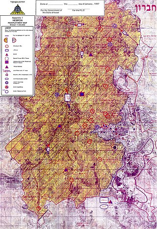
The Protocol Concerning the Redeployment in Hebron, also known as the Hebron Protocol or Hebron Agreement, was signed on 17 January 1997 by Israel, represented by Prime Minister of Israel Benjamin Netanyahu, and the Palestine Liberation Organization (PLO), represented by PLO Chairman Yasser Arafat, under the supervision of U.S. Secretary of State, Warren Christopher. It concerned the partial redeployment of Israeli military forces from Hebron in accordance with the 1995 Interim Agreement on the West Bank and the Gaza Strip. According to the Protocol, Area H-1 would come under Palestinian control, while Area H-2 would remain under Israeli control. A large Palestinian majority still lives in both Area H-1 and Area H-2. The redeployment started on 16 January 1997. The protocol has never been ratified by either of the contracting parties.

<span class="mw-page-title-main">Israeli-occupied territories</span> Territories presently occupied by Israel since the 1967 Six-Day War

Israel has occupied the Palestinian territories and the Golan Heights since the Six-Day War of 1967. It previously occupied the Sinai Peninsula and southern Lebanon as well. Prior to Israel's victory in the Six-Day War, occupation of the Palestinian territories was split between Egypt and Jordan, with the former having occupied the Gaza Strip and the latter having annexed the West Bank; the Sinai Peninsula and the Golan Heights were under the sovereignty of Egypt and Syria, respectively. The first conjoined usage of the terms "occupied" and "territories" with regard to Israel was in United Nations Security Council Resolution 242, which was drafted in the aftermath of the Six-Day War and called for: "the establishment of a just and lasting peace in the Middle East" to be achieved by "the application of both the following principles: ... Withdrawal of Israeli armed forces from territories occupied in the recent conflict ... Termination of all claims or states of belligerency and respect for and acknowledgment of the sovereignty, territorial integrity and political independence of every State in the area and their right to live in peace within secure and recognized boundaries free from threats or acts of force."

<span class="mw-page-title-main">Israeli Civil Administration</span> Governing body in the West Bank

The Civil Administration is the Israeli governing body that operates in the West Bank. It was established by the government of Israel in 1981, in order to carry out practical bureaucratic functions within the territories captured by Israel in 1967. While formally separate, it was subordinate to the Israeli military and the Shin Bet.

The international community considers the establishment of Israeli settlements in the Israeli-occupied territories illegal on one of two bases: that they are in violation of Article 49 of the Fourth Geneva Convention, or that they are in breach of international declarations. The United Nations Security Council, the United Nations General Assembly, the International Committee of the Red Cross, the International Court of Justice and the High Contracting Parties to the Convention have all affirmed that the Fourth Geneva Convention applies to the Israeli-occupied territories.

<span class="mw-page-title-main">Israeli settlement timeline</span>

This is a timeline of the development of and controversy over Israeli settlements. As of January 30, 2022 the West Bank settlement population was 490,493 and the settler population in the Golan Heights was almost 27,000 and in East Jerusalem the settler population was around 220,000.

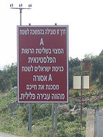
An Israeli military order is a general order issued by an Israeli military commander over territory under Israeli military occupation. It has the force of law. Enforcement of such orders is carried out by Israeli military police and military courts instead of civil courts.

<span class="mw-page-title-main">Oslo Accords</span> 1993–1995 Israeli–Palestinian peace agreements

The Oslo Accords are a pair of interim agreements between Israel and the Palestine Liberation Organization (PLO): the Oslo I Accord, signed in Washington, D.C., in 1993; and the Oslo II Accord, signed in Taba, Egypt, in 1995. They marked the start of the Oslo process, a peace process aimed at achieving a peace treaty based on Resolution 242 and Resolution 338 of the United Nations Security Council. The Oslo process began after secret negotiations in Oslo, Norway, resulting in both the recognition of Israel by the PLO and the recognition by Israel of the PLO as the representative of the Palestinian people and as a partner in bilateral negotiations.

<span class="mw-page-title-main">Israeli Military Governorate</span> Military governance system (1967–1981/82)

The Israeli Military Governorate was a military governance system established following the Six-Day War in June 1967, in order to govern the civilian population of the West Bank, the Gaza Strip, the Sinai Peninsula and the western part of Golan Heights. The governance was based on the Fourth Geneva Convention, which provides guidelines for military rule in occupied areas. East Jerusalem was the only exception from this order, and it was added to Jerusalem municipal area as early as 1967, and extending Israeli law to the area effectively annexing it in 1980. During this period, the UN and many sources referred to the military governed areas as Occupied Arab Territories.

<span class="mw-page-title-main">Area C (West Bank)</span> Oslo II division of the West Bank under full Israeli control

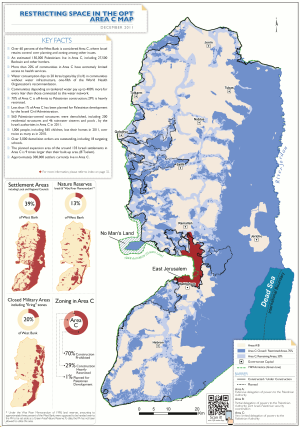
Area C is the fully Israeli-controlled and only contiguous territory in the West Bank, defined as the whole area outside the Palestinian enclaves. Area C constitutes about 61 percent of the West Bank territory, contains all Israeli settlements other than those in East Jerusalem, and more than 99% of the area is off limits or heavily restricted for Palestinians. The area was committed in 1995 under the Oslo II Accord to be "gradually transferred to Palestinian jurisdiction", but such transfer did not happen. The area is richly endowed with natural resources.

<span class="mw-page-title-main">Palestinian enclaves</span> Fragmentation of the West Bank over time

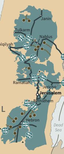
The Palestinian enclaves are areas in the West Bank designated for Palestinians under a variety of unsuccessful U.S. and Israeli-led proposals to end the Israeli–Palestinian conflict. The enclaves are often compared to the nominally self-governing black homelands created in apartheid-era South Africa, and are thus referred to as bantustans. They have been referred to figuratively as the Palestinian archipelago, among other terms. The de facto status in 2024 is that Israel controls all area outside these enclaves.

References

  1. Burns, Jacob; Perugini, Nicola (2016). "Untangling the Oslo Lines". In Manna, Jumana; Storihle, Sille (eds.). The Goodness Regime (PDF). p. 40. The process was very easy. In the agreement signed in '93, all those areas that would be part of final status agreement—settlements, Jerusalem, etc.—were known. So I took out those areas, along with those roads and infrastructure that were important to Israel in the interim period. It was a new experience for me. I did not have experience of mapmaking before. I of course used many different civilian and military organizations to gather data on the infrastructure, roads, water pipes, etc. I took out what I thought important for Israel.
  2. 1 2 3 4 5 6 What is Area C?. B'Tselem, 9 October 2013
  3. Hass, Amira (2012-01-12). "EU Report: Israel Policy in West Bank Endangers Two-state Solution". Haaretz. Retrieved 2016-06-15.
  4. "15,000 More Jews in Judea-Samaria in 2014". Arutz Sheva. 2 January 2015. Retrieved 2016-06-15.
  5. "Estimated Population in the Palestinian Territory Mid-Year by Governorate,1997-2016". Palestinian Central Bureau of Statistics. State of Palestine. Archived from the original on 8 June 2014. Retrieved 8 June 2014.
  6. 1 2 3 4 Israeli-Palestinian Interim Agreement on the West Bank and the Gaza Strip, Article I "Transfer of Authority"; Article XI "Land", par. 3. 28 September 1995 (Oslo II Accord)
  7. 1 2 3 Gvirtzman, Haim. "Maps of Israeli Interests in Judea and Samaria Determining the Extent of the Additional Withdrawals". (this study was funded by the Settlement Division of the Zionist Organization)
  8. Nahum Barnea, 'Beitunian nights: The IDF in the West Bank,' Ynet 18 March 2016.
  9. Cohen, Gili; Khoury, Jack (December 11, 2016). "Palestinian Security Forces Deny IDF Troops Entry to Jenin". Haaretz.
  10. 1 2 3 4 The demise of the Oslo process. Joel Beinin, MERIP, 26 March 1999.
    In area B, consisting of about 23 percent of the territory (including some 440 villages and their surrounding lands), the Palestinians are responsible for certain municipal functions, while joint Israeli-Palestinian patrols maintain internal security. Area C, consisting of about 74 percent of the territory including all of the 145 settlements and the new Jewish neighborhoods in and around East Jerusalem, remains under full Israeli control.
  11. MFA, "Map No. 1 – First Phase of Redeployment"
  12. New York Times, 23 July 2012, "Israel Seeks Army Use of West Bank Area"
  13. "West Bank: Area C Map". UNISPAL, 22 February 2011; from OCHAoPt
  14. 'Kerry: Israel 'imperilling' two-state solution,' Ma'an News Agency 6 December 2015.
  15. Diab, Khaled (6 September 2012). "Bedouin kids' school of hard knocks". Haaretz. Retrieved 9 September 2012.
  16. 1 2 UN: 300,000 Palestinians live in Area C of the West Bank. Jerusalem Post, 6 March 2014
  17. Ron Pundak, "Decoding Bibi's West Bank agenda," Haaretz , 3 August 2012.
  18. 1 2 3 Annex I: Protocol Concerning Redeployment and Security Arrangements, Article I—"Redeployment of Israeli Military Forces and Transfer of Responsibility", par. 6, 9–10. Annex to the Interim Agreement on the West Bank and the Gaza Strip (Oslo II)
  19. 1 2 "West Bank and Gaza – Area C and the future of the Palestinian economy". World Bank. 2 October 2013. pp. xi, 4.
  20. Associated Press, "Palestinians lose billions to Israeli land bans, says World Bank report," The National, October 8, 2013: "Without the ability to conduct purposeful economic activity in Area C, the economic space of the West Bank will remain crowded and stunted, inhabited by people whose daily interactions with the state of Israel are characterised by inconvenience, expense and frustration."
  21. 1 2 Danny Rubenstein, "The Palestinian economy: Israel's control over Area C comes at a price". Ynet, 9 February 2015.
  22. "Palestinians in West Bank's Area C suffer in limbo," Los Angeles Times, 18 May 2013.
  23. "West Bank settlements: Bulldozers at the ready". The Economist . Retrieved 2 August 2015.
  24. 1 2 Dalia Hatuga, "Report reveals scale of Israel's home demolitions,". Al Jazeera, 7 September 2015
  25. 1 2 Under threat—Demolition orders in Area C of the West Bank Archived 2015-11-22 at the Wayback Machine . UN OCHA, 3 September 2015
  26. "Villagers expand first Palestinian settlement". International Solidarity Movement. 8 February 2005. Retrieved 16 January 2013.
  27. "Palestinian protest on land assigned for E1 settlement". BBC. 11 January 2013. Retrieved 16 January 2013.
  28. Zianta, Rana (23 January 2013). "Palestinian village Bab Al Karama demolished". Al Arabiya. Retrieved 5 October 2016.
  29. , and was also evacuated few days later
  30. Haaretz, Akiva Eldar, West Bank outposts spreading into Area B, in violation of Oslo Accords. 18 February 2012.
  31. "3. Annex III - Protocol Concerning Civil Affairs". unispal.un.org.[ dead link ]
  32. 1 2 "The Israeli-Palestinian Interim Agreement on the West Bank and the Gaza Strip: Annex III, Protocol Concerning Civil Affairs". Ministry of Foreign Affairs (Israel). 28 September 1995. Retrieved 25 November 2022.
  33. Kershner, Isabel (2015-10-16). "Palestinians Burn Jewish Holy Site in West Bank as Clashes Kill 4". The New York Times. ISSN   0362-4331 . Retrieved 2019-12-03.
  34. "Tisha Be'av in the PA's Hebron". The Jerusalem Post | JPost.com. Retrieved 2019-12-03.