
West End Museum
The West End Museum is a neighborhood museum dedicated to the collection, preservation and interpretation of the history and culture of the West End of Boston.
The West End Museum is a neighborhood museum dedicated to the collection, preservation and interpretation of the history and culture of the West End of Boston.
In 1989 the editors of the West Ender Newsletter and members of the West End Historical Association developed a preliminary plan for a West End Museum. In 1991 The Old West End Housing Corporation (OWEHC) was formed as a Community Development Corporation (CDC) with the mission of developing affordable housing for former West End residents who were displaced by the Urban Renewal of the 1950s when their houses were seized by eminent domain. [1] After helping to develop affordable housing for former West Enders at West End Place at 150 Staniford Street, Boston, MA 02114, The OWEHC was awarded a commercial space, in 2002, for its offices along with the stipulation that it develop a West End Visitor Center. [2] In 2003 The Bostonian Society donated and relocated the “Last Tenement” exhibit to 150 Staniford St. This was an exhibition displayed in the Old State House from October 1992 through April 1994, rendering the plight of the West End neighborhood. The exhibit laid the foundation for a permanent West End Museum. In 2010 Members of the OWEHC along with West End residents formed a committee with the goal to establish a permanent 501(c) 3 non-profit called The West End Museum, Inc. [3]
The museum consists of three exhibition areas and an archives. They also host regular programming. The permanent exhibit "The Last Tenement", designed by the Bostonian Society in 1992 and relocated to the West End Museum in 2003, is housed in its own dedicated 1,100-square-foot (100 m2) space. The large exhibition space (1400 sq ft) mounts three revolving shows per year. Shows have included: "The Middlesex Canal: Boston's First Big Dig" [4] and "Leaving the River.” [5] The Members Gallery adjacent to the administrative offices mounts 6 revolving shows each year. Past shows in this space include: West End photographs from the archives of the Bostonian Society, "The Boston Canal", which was an extension of the Middlesex Canal through Causeway Street in the Bulfinch Triangle to Haymarket Square, and "Twenty Five Years of the West Ender Newsletter".

Cambridge is a city in Middlesex County, Massachusetts, and part of the Boston metropolitan area as a major suburb of Boston. As of the 2020 United States Census, the city's population was 118,403, making it the fourth most populous city in the state, behind Boston, Worcester, and Springfield. It is one of two de jure county seats of Middlesex County, although the county's government was abolished in 1997. Situated directly north of Boston, across the Charles River, it was named in honor of the University of Cambridge in England, once also an important center of the Puritan theology embraced by the town's founders.

Lowell is a city in Massachusetts, in the United States. With Cambridge, Lowell is one of two traditional seats of Middlesex County. With an estimated population of 115,554 in 2020, it was the fifth most populous city in Massachusetts as of the last census, and the second most populous in the Boston metropolitan statistical area. The city also is part of a smaller Massachusetts statistical area, called Greater Lowell, and of New England's Merrimack Valley region.

Medford is a city 6.7 miles (10.8 km) northwest of downtown Boston on the Mystic River in Middlesex County, Massachusetts, United States. At the time of the 2020 U.S. Census, Medford's population was 59,659. It is home to Tufts University, which has its campus along the Medford and Somerville border.

Somerville is a city located directly to the northwest of Boston, and north of Cambridge, in Middlesex County, Massachusetts, United States. As of the 2020 United States Census, the city had a total population of 81,045 people. With an area of 4.12 square miles (10.7 km2), the city has a density of 19,671/sq mi (7,595/km2), making it the most densely populated municipality in New England and the 16th most densely populated incorporated municipality in the country. Somerville was established as a town in 1842, when it was separated from Charlestown. In 2006, the city was named the best-run city in Massachusetts by The Boston Globe. In 1972, 2009, and 2015, the city received the All-America City Award. It is home to Tufts University, which has its campus along the Somerville and Medford border.

Charlestown is the oldest neighborhood in Boston, Massachusetts, in the United States. Originally called Mishawum by the Massachusett tribe, it is located on a peninsula north of the Charles River, across from downtown Boston, and also adjoins the Mystic River and Boston Harbor waterways. Charlestown was laid out in 1629 by engineer Thomas Graves, one of its earliest settlers, in the reign of Charles I of England. It was originally a separate town and the first capital of the Massachusetts Bay Colony.

Davis Square is a major intersection in the northwestern section of Somerville, Massachusetts where several streets meet: Holland Street, Dover Street, Day Street, Elm Street, Highland Avenue, and College Avenue. The name is often used to refer to the West Somerville neighborhood surrounding the square as well.

The Rose Fitzgerald Kennedy Greenway is a linear park located in several Downtown Boston neighborhoods. It consists of landscaped gardens, promenades, plazas, fountains, art, and specialty lighting systems that stretch over one mile through Chinatown, the Financial District, the Waterfront, and North End neighborhoods. Officially opened in October 2008, the 17-acre Greenway sits on land created from demolition of the John F. Fitzgerald Expressway under the Big Dig.
The Charles River Dam Bridge, officially the Craigie Bridge, also called Craigie's Bridge or the Canal Bridge, is a six-lane bascule bridge across the Charles River in the West End neighborhood of Boston. The bridge, maintained by the Massachusetts Department of Conservation and Recreation, carries Massachusetts Route 28 next to the Green Line's Lechmere Viaduct. The Museum of Science is located on the dam and nearby piers. Charles River Dam Road connects Leverett Circle in the West End to East Cambridge, but most of the road is fixed, and the asymmetrically sited drawbridge is a short span entirely on the Boston side of the river.
East Cambridge is a neighborhood of Cambridge, Massachusetts. Referred to in modern times as Area 1, East Cambridge is bounded by the Charles River and the Charlestown neighborhood of Boston on the east, the Somerville border on the north, Broadway and Main Street on the south, and the railroad tracks on the west. Most of the streets form a grid aligned with Cambridge Street, which was laid out to directly connect what is now the Charles River Dam Bridge with what in 1809 was the heart of Cambridge, Harvard Square. The northern part of the grid is a roughly six by eight block residential area. Cambridge Street itself is retail commercial, along with Monsignor O'Brien Highway, the Twin Cities Plaza strip mall, and the enclosed Cambridgeside Galleria. Lechmere Square is the transportation hub for the northern side. The southern half of the grid is largely office and laboratory space for hundreds of dot-com companies, research labs and startups associated with MIT, biotechnology firms including Genzyme, Biogen and Moderna, the Athenaeum Press Building, light industry, an NRG Energy power station, and various small businesses. This half of the neighborhood is generally identified with Kendall Square. Along the waterfront are several hotels and taller apartment buildings.

The Lower East Side Tenement Museum, located at 97 and 103 Orchard Street in the Lower East Side neighborhood of Manhattan, New York City, is a National Historic Site. The Museum's two historical tenement buildings were home to an estimated 15,000 people, from over 20 nations, between 1863 and 2011. The museum, which includes a visitors' center, promotes tolerance and historical perspective on the immigrant experience.

South Medford is the southern neighborhood of Medford, Massachusetts.

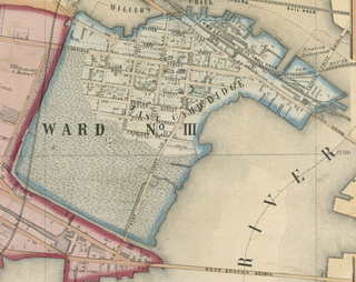
The West End is a neighborhood of Boston, Massachusetts, bounded generally by Cambridge Street to the south, the Charles River to the west and northwest, North Washington Street on the north and northeast, and New Sudbury Street on the east. Beacon Hill is to the south, North Point is across the Charles River to the north, Kendall Square is across the Charles River to the west, and the North End is to the east. A late 1950s urban renewal project razed a large African American, Italian and Jewish enclave and displaced over 20,000 people in order to redevelop much of the West End and part of the neighboring Downtown neighborhood. Today, much of the original West End is non-residential, including part of Government Center as well as much of Massachusetts General Hospital and several high rise office buildings.

North Billerica is an unincorporated village of the town of Billerica, Massachusetts, United States, one of the nine sections (hamlets) that make up the Town of Billerica. It is the home to Faulkner and Talbot mills and the North Billerica Train Depot. The Middlesex Canal was built through the village in 1783 and the Boston and Lowell Railroad was put through in the 1840s.

Assembly Square is a neighborhood in Somerville, Massachusetts. It is located along the west bank of the Mystic River, bordered by Ten Hills and Massachusetts Route 28 to the north and the Charlestown neighborhood of Boston to the south. The district's western border runs along Interstate 93. Located 2.5 mi (4.0 km) from downtown Boston, the 143 acres (580,000 m2) parcel is named for a former Ford Motor Company plant that closed in 1958.

The North End Parks are the two northernmost parks on the Rose Kennedy Greenway, built over O'Neill Tunnel in Boston, Massachusetts and adjacent to the neighborhood known as the North End. Two landscape architecture firms designed the 3-acre (12,000 m2) North End Parks.
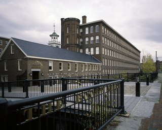
The Boott Mills in Lowell, Massachusetts were a part of an extensive group of cotton mills, built in 1835 alongside a power canal system in this important cotton town. Their founder was Kirk Boott, one of the early mill owners in Lowell. Today, the Boott Mills complex is the most intact in Lowell and is part of Lowell National Historical Park. It houses the Boott Cotton Mills Museum.
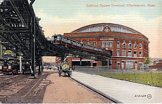
Sullivan Square is a traffic circle located at the north end of the Charlestown neighborhood of Boston, Massachusetts. It is named after James Sullivan, an early 19th-century Governor of Massachusetts. Sullivan Square station on the MBTA Orange Line is located just west of the square.
The West Ender is a Boston-based newspaper founded in 1985 by Jim Campano, who still serves as the editor and publisher.
The Seaport District, or simply the Seaport, is a neighborhood in Boston, Massachusetts. It is part of the larger neighborhood of South Boston, and is also sometimes called the Innovation District. The Seaport is a formerly industrial area that has undergone an extensive redevelopment effort in recent years. It is bordered by the Fort Point Channel to the west, Boston Harbor to the north and east, and the historic residential neighborhood of South Boston to the south. It is officially referred to by the City of Boston as The South Boston Waterfront. The Seaport District is at extreme risk of climate-related flooding over the next 30 years.

Jules Aarons was an American space physicist known for his study of radio-wave propagation, and a photographer known for his street photography in Boston.