West Island, Cocos (Keeling) Islands

Last updated

West Island
Native name:
Malay: Pulau Panjang
Cocos Malay: Pulu Panjang
Cocos (Keeling) Islands (32206670676).jpg
Cocos (Keeling) Islands-CIA WFB Map.png
The Cocos (Keeling) Islands, showing West Island
Cocos (Keeling) Islands location map.svg
Red pog.svg
West Island
West Island in the Cocos (Keeling) Islands
Geography
Location Indian Ocean
Coordinates 12°11′13″S96°49′42″E / 12.18694°S 96.82833°E / -12.18694; 96.82833
Archipelago Cocos (Keeling) Islands
Area6.23 km2 (2.41 sq mi)
Administration
Australia
External territory of Australia Australian Indian Ocean Territories
Territory Cocos (Keeling) Islands
Capital city Canberra
Demographics
Population120
Languages
Additional information
Time zone

West Island (Malay : Pulau Panjang, Cocos Islands Malay : Pulu Panjang), part of the South Keeling Islands, is the capital of the Cocos (Keeling) Islands, an Australian external territory in the Indian Ocean. The population is roughly 120, making it the third smallest capital in the world, and consists mainly of Europeans. It is less populous than Home Island, the only other inhabited island.

Contents

West Island was part of the Clunies-Ross plantation and an airstrip was built here during World War II. As well as all the government buildings, it contains the airport, a general store and tourist accommodation. In November 2013 it was revealed that the Australian Signals Directorate operates a listening station on West Island. [1]

Education

Cocos Islands District High School operates a primary and secondary campus on West Island. Most of the students of that campus originate from the Australian continent. [2]

Heritage listings

West Island contains a number of heritage-listed sites, including:

Climate

West Island experiences a tropical rainforest climate (Köppen: Af, Trewartha: Aral), with hot and humid conditions experiences year round. The islands experience two seasons that often overlap: the trade wind season from May/June to September/October, and the calmer doldrum season from November through to May. [13] Precipitation is moderate to high year round, thanks to its position at the southern edge of the equatorial low pressure belt. North-west monsoons deliver rain during the doldrum, while the southeastern trade winds also give rain for much of the year. [14] Cyclones have the potential to seriously effect the flora and fauna on the island. The 1989-90 South-West Indian Ocean cyclone season caused damage to the islands, with Tropical Cyclone Walter hitting the island around the 13th of March 1990. [15] Extreme temperatures, however, are subdued by the influence of the Indian Ocean. Extremes only range from 32.8 °C (91.0 °F) on 23 February 2017 to 20.4 °C (68.7 °F) on 27 December 2018.

Climate data for Cocos Island Airport (1991-2020 normals, extremes 1998–present)
MonthJanFebMarAprMayJunJulAugSepOctNovDecYear
Record high °C (°F)32.2
(90.0)
32.8
(91.0)
32.7
(90.9)
32.8
(91.0)
31.6
(88.9)
30.9
(87.6)
30.3
(86.5)
30.6
(87.1)
30.1
(86.2)
31.0
(87.8)
31.1
(88.0)
31.6
(88.9)
32.8
(91.0)
Mean daily maximum °C (°F)30.1
(86.2)
30.2
(86.4)
30.2
(86.4)
30.0
(86.0)
29.5
(85.1)
28.8
(83.8)
28.3
(82.9)
28.1
(82.6)
28.3
(82.9)
28.8
(83.8)
29.2
(84.6)
29.5
(85.1)
29.2
(84.6)
Daily mean °C (°F)27.7
(81.9)
27.8
(82.0)
27.9
(82.2)
27.9
(82.2)
27.5
(81.5)
26.9
(80.4)
26.4
(79.5)
26.2
(79.2)
26.3
(79.3)
26.7
(80.1)
27.1
(80.8)
27.2
(81.0)
27.1
(80.8)
Mean daily minimum °C (°F)25.2
(77.4)
25.4
(77.7)
25.5
(77.9)
25.7
(78.3)
25.5
(77.9)
25.0
(77.0)
24.4
(75.9)
24.3
(75.7)
24.4
(75.9)
24.6
(76.3)
24.9
(76.8)
24.9
(76.8)
25.0
(77.0)
Record low °C (°F)21.0
(69.8)
21.8
(71.2)
21.8
(71.2)
21.9
(71.4)
21.2
(70.2)
22.2
(72.0)
20.6
(69.1)
20.9
(69.6)
20.9
(69.6)
21.2
(70.2)
21.6
(70.9)
20.4
(68.7)
20.4
(68.7)
Average precipitation mm (inches)151.7
(5.97)
207.1
(8.15)
239.4
(9.43)
249.3
(9.81)
187.7
(7.39)
187.3
(7.37)
180.9
(7.12)
102.4
(4.03)
86.2
(3.39)
84.8
(3.34)
89.7
(3.53)
121.4
(4.78)
1,886.6
(74.28)
Average precipitation days (≥ 1 mm)10.212.215.414.113.913.914.711.18.46.26.38.6135.0
Source: Australian Bureau of Meteorology [16]

See also

Related Research Articles

<span class="mw-page-title-main">Cocos (Keeling) Islands</span> Australian islands in the Indian Ocean

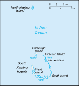
The Cocos (Keeling) Islands, officially the Territory of Cocos (Keeling) Islands, are an Australian external territory in the Indian Ocean, comprising a small archipelago approximately midway between Australia and Sri Lanka and relatively close to the Indonesian island of Sumatra. The territory's dual name reflects that the islands have historically been known as either the Cocos Islands or the Keeling Islands.

<span class="mw-page-title-main">Home Island</span> Island of the Cocos (Keeling) Islands, Australia

Home Island, also known locally as Pulu Selma, is one of only two permanently-inhabited islands of the 26 islands of the South Keeling Islands of the Cocos (Keeling) Islands, an Australian external territory in the central-eastern Indian Ocean.

<span class="mw-page-title-main">2001–02 Australian region cyclone season</span>

The 2001–02 Australian region cyclone season was a slightly below average tropical cyclone season. It officially started on 1 November 2001, and ended on 30 April 2002. However, the formation of Tropical Cyclone Alex on 26 October 2001 marked an earlier beginning to the season, and the season extended past the official end of the season when Tropical Cyclone Upia formed on 25 May 2002. The regional tropical cyclone operational plan also defines a "tropical cyclone year" separately from a "tropical cyclone season"; the "tropical cyclone year" began on 1 July 2001 and ended on 30 June 2002. The scope of the Australian region is limited to all areas south of the equator, east of 90°E and west of 160°E. This area includes Australia, Papua New Guinea, western parts of the Solomon Islands, East Timor and southern parts of Indonesia.

<span class="mw-page-title-main">Cyclone Savannah</span> Australian region tropical cyclone

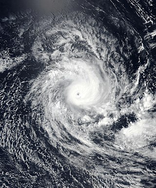
Severe Tropical Cyclone Savannah was a strong tropical cyclone that brought significant impacts to Java and Bali and minor impacts to Christmas Island and the Cocos (Keeling) Islands during March 2019. It was the sixteenth tropical low, sixth tropical cyclone and third severe tropical cyclone of the 2018–19 Australian region cyclone season. Savannah developed from a tropical low that formed well to the east of Christmas Island on 8 March. The system was slow to develop initially, but reached tropical cyclone intensity on 13 March after adopting a southwesterly track. Savannah underwent rapid intensification and reached peak intensity on 17 March as a Category 4 severe tropical cyclone on the Australian scale. Ten-minute sustained winds were estimated as 175 kilometres per hour (109 mph), with a central barometric pressure of 951 hPa (28.08 inHg). One-minute sustained winds reached 185 kilometres per hour (115 mph) at this time, equivalent to a Category 3 major hurricane on the Saffir–Simpson hurricane wind scale. Weakening commenced soon afterwards, and responsibility for the system passed from the Australian Bureau of Meteorology to Météo-France. As it moved into the new region, Savannah became the eighth of a record-breaking ten intense tropical cyclones in the 2018–19 South-West Indian Ocean cyclone season. Savannah was downgraded to a tropical depression on 20 March, and its remnants dissipated in the central Indian Ocean on 24 March.

The West Island Mosque is a heritage-listed mosque at Alexander Street, West Island, of the Cocos (Keeling) Islands, an external territory of Australia. The mosque was added to the Australian Commonwealth Heritage List on 22 June 2004.

The Home Island Industrial Precinct is a heritage-listed industrial area at Jalan Bunga Mawar, Home Island, Cocos (Keeling) Islands, Australia. It was added to the Australian Commonwealth Heritage List on 22 June 2004.

The Direction Island Slipway and Tank are heritage-listed industrial remnants at Direction Island, Cocos (Keeling) Islands, Australia. The site was added to the Australian Commonwealth Heritage List on 22 June 2004.

The West Island Housing Precinct is a heritage-listed residential area at Air Force Road, West Island, Cocos (Keeling) Islands, Australia. It was added to the Australian Commonwealth Heritage List on 22 June 2004.

<span class="mw-page-title-main">Oceania House</span> Historic house in Cocos Islands of Australia

Oceania House is a heritage-listed house at Jalan Bunga Kangkong, Home Island, Cocos (Keeling) Islands, Australia. It was added to the Australian Commonwealth Heritage List on 22 June 2004.

Government House is a heritage-listed official residence at Qantas Close, West Island, Cocos (Keeling) Islands, Australia. It was added to the Australian Commonwealth Heritage List on 22 June 2004.

The RAAF Memorial is a heritage-listed war memorial at West Island, Cocos (Keeling) Islands, Australia. It was added to the Australian Commonwealth Heritage List on 22 June 2004.

The Qantas Huts are heritage-listed former accommodation huts at Sydney Highway, West Island, Cocos (Keeling) Islands, Australia. They were added to the Australian Commonwealth Heritage List on 22 June 2004.

The Administration Building Forecourt is a heritage-listed garden and memorial precinct at Morea Close, West Island, Cocos (Keeling) Islands, Australia. It was added to the Australian Commonwealth Heritage List on 22 June 2004.

The Type 2 Residences are six heritage-listed houses at Air Force Road, West Island, Cocos (Keeling) Islands, Australia. It was added to the Australian Commonwealth Heritage List on 22 June 2004.

Direction Island (DI) Houses is a heritage-listed houses at Air Force Road, West Island, Cocos (Keeling) Islands, Australia. It was added to the Australian Commonwealth Heritage List on 22 June 2004.

The West Island Elevated Houses are heritage-listed houses at Orion Close, West Island, Cocos (Keeling) Islands, Australia. It was added to the Australian Commonwealth Heritage List on 22 June 2004.

The Home Island Foreshore is a heritage-listed cultural landscape at Jalan Panti, Home Island, Cocos (Keeling) Islands, Australia. It was added to the Australian Commonwealth Heritage List on 22 June 2004.

The Type T Houses Precinct is a heritage-listed residential area at William Keeling Crescent and Qantas Close, West Island Settlement, Cocos (Keeling) Islands, Australia. It was added to the Australian Commonwealth Heritage List on 22 June 2004.

The Old Co-op Shop is a heritage-listed retail building at Jalan Bunga Mawar, Home Island, Cocos (Keeling) Islands, Australia. It was added to the Australian Commonwealth Heritage List on 22 June 2004.

<span class="mw-page-title-main">Malay Kampong Group</span> Historic site in Christmas Island, Australia

Malay Kampong Group is a heritage-listed Malay precinct at Jalan Panyai, Flying Fish Cove in the Australian territory of Christmas Island. It was added to the Australian Commonwealth Heritage List on 22 June 2004.

References

  1. Dorling, Philip (1 November 2013). "Listening post revealed on Cocos Islands". Canberra Times. Archived from the original on 3 November 2013.
  2. Home. Cocos Islands District High School. Retrieved on 8 April 2019.
  3. "Administration Building Forecourt (Place ID 105356)". Australian Heritage Database . Australian Government . Retrieved 15 May 2019.
  4. "Direction Island (DI) Houses (Place ID 105358)". Australian Heritage Database . Australian Government . Retrieved 15 May 2019.
  5. "Government House (Place ID 105360)". Australian Heritage Database . Australian Government . Retrieved 15 May 2019.
  6. "Qantas Huts (former) (Place ID 105354)". Australian Heritage Database . Australian Government . Retrieved 15 May 2019.
  7. "RAAF Memorial (Place ID 105353)". Australian Heritage Database . Australian Government . Retrieved 15 May 2019.
  8. "Type 2 Residences (Place ID 105357)". Australian Heritage Database . Australian Government . Retrieved 15 May 2019.
  9. "Type T Houses Precinct (Place ID 105408)". Australian Heritage Database . Australian Government . Retrieved 15 May 2019.
  10. "West Island Elevated Houses (Place ID 105359)". Australian Heritage Database . Australian Government . Retrieved 15 May 2019.
  11. "West Island Housing Precinct (Place ID 105223)". Australian Heritage Database . Australian Government . Retrieved 15 May 2019.
  12. "West Island Mosque (Place ID 105219)". Australian Heritage Database . Australian Government . Retrieved 15 May 2019.
  13. "Weather & Tides | Cocos Keeling Islands". www.cocoskeelingislands.com.au. Retrieved 23 April 2022.
  14. "Climate - DAWE". www.awe.gov.au. Retrieved 23 April 2022.
  15. "Tropical Cyclone WALTER". australiasevereweather.com. Retrieved 23 April 2022.
  16. "Cocos Island Airport Climate". Australian Bureau of Meteorology.