West Point, Indiana

Last updated

West Point, Indiana
West Point, Indiana street.png
Looking east along Jefferson Street
Tippecanoe County Indiana Incorporated and Unincorporated areas West Point Highlighted 1883222.svg
Location of West Point in Tippecanoe County, Indiana.
Coordinates: 40°20′52″N87°02′16″W / 40.34778°N 87.03778°W / 40.34778; -87.03778
Country United States
State Indiana
County Tippecanoe
Township Wayne
Area
[1]
  Total2.77 sq mi (7.18 km2)
  Land2.77 sq mi (7.18 km2)
  Water0.00 sq mi (0.00 km2)
Elevation
[2]
646 ft (197 m)
Population
 (2020)
  Total318
  Density114.72/sq mi (44.29/km2)
Time zone UTC-5 (Eastern (EST))
  Summer (DST) UTC-4 (EDT)
ZIP code
47992
Area code 765
GNIS feature ID2583475 [2]

West Point (sometimes shown as Westpoint [3] ) is an unincorporated community and census-designated place in Wayne Township, Tippecanoe County, in the U.S. state of Indiana. [2] The population was 594 at the 2010 census.

Contents

The community is part of the Lafayette, Indiana Metropolitan Statistical Area.

History

The town was platted in 1833 by Samuel Kiser. [4] It was founded as Middleton, but residents changed the name of the town to West Point. [5]

The West Point post office has been in operation since 1836. [6]

Geography

West Point in 1878. West Point, Indiana 1878.png
West Point in 1878.

West Point is located at 40°20′42″N87°2′35″W / 40.34500°N 87.04306°W / 40.34500; -87.04306 (40.345036, -87.043066) along State Road 25 at an elevation of approximately 673 feet. The town is in Wayne Township and sits about a quarter of a mile north of Flint Creek which flows west to the Wabash River.

A village named Glen Hall existed on the north side of West Point in the 19th century; though still populated, the site is now generally considered part of West Point. Additionally, residents of the former town of Granville are listed using West Point addresses.

Demographics

Historical population
CensusPop.Note
2020 318
U.S. Decennial Census [7]

Economy

Most residents of West Point are employed outside of the main portion of the town with agriculture and businesses in Lafayette and West Lafayette. There are a number of equestrian centers and horse barns with close ties to the town.

Religion

West Point is home to one church, West Point United Methodist. Another church was closed and converted to an antiques shop in the early 2010s.

There are several cemeteries and gravesites within the area. West Point Cemetery is the only one mainly located in the town.

Community

West Point has a growing level of community involvement, which primarily revolves around West Point Park (the former location of West Point High School, now demolished) and the West Point Volunteer Fire Department. Each year, the Volunteer Fire Department puts on a community fish fry to raise funds for equipment. Halloween is a special time and the entire community is involved in Light Up The Night, a designated night for costumes, food, and candy.

Education

West Point residents are served by Tippecanoe School Corporation. West Point High School, home of the West Point Cadets, was consolidated into Southwestern HS in 1956, along with Shadeland, Romney, Wea & Jackson. In 1972, Southwestern was consolidated into McCutcheon High School. [8] Elementary and middle school students report to Mintonye Elementary School and Southwestern Middle School respectively.

Related Research Articles

<span class="mw-page-title-main">White County, Indiana</span> County in Indiana, United States

White County is a county in the U.S. state of Indiana. As of the 2020 United States Census, the population was 24,688. The county seat is Monticello.

<span class="mw-page-title-main">Warren County, Indiana</span> County in Indiana, United States

Warren County is a county in the U.S. state of Indiana. It lies in the western part of the state between the Illinois state line and the Wabash River. According to the 2020 census, it had a population of 8,440. Its county seat is Williamsport.

<span class="mw-page-title-main">Tippecanoe County, Indiana</span> County in Indiana, United States

Tippecanoe County is located in the west-central portion of the U.S. state of Indiana about 22 miles east of the Illinois state line and less than 50 miles from the Chicago and the Indianapolis metro areas. As of the 2020 census, the population was 186,251. The county seat and largest city is Lafayette. It was created in 1826 from Wabash County portion of New Purchase and unorganized territory.

<span class="mw-page-title-main">Randolph County, Indiana</span> County in Indiana, United States

Randolph County is a county located in the central section of U.S. state of Indiana, on its eastern border with Ohio. As of 2020, the population was 24,502. The county seat is Winchester.

<span class="mw-page-title-main">Fountain County, Indiana</span> County in Indiana, United States

Fountain County lies in the western part of the U.S. state of Indiana on the east side of the Wabash River. The county was officially established in 1826 and was the 53rd in Indiana. The county seat is Covington.

<span class="mw-page-title-main">Carroll County, Indiana</span> County in Indiana, United States

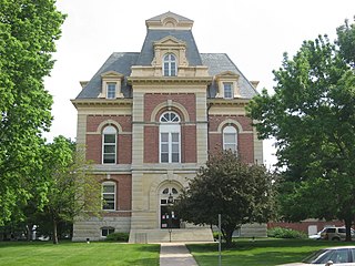
Carroll County is a county located in the U.S. state of Indiana. As of the 2020 United States Census, the population was 20,306. The county seat is Delphi.

<span class="mw-page-title-main">Benton County, Indiana</span> County in Indiana, United States

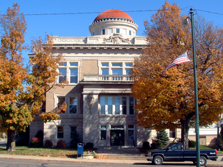
Benton County is located in the northwest part of the U.S. state of Indiana, along the border with Illinois. As of 2020, the county's population was 8,719. It contains six incorporated towns as well as several small unincorporated settlements; it is divided into 11 townships which provide local services. The county seat is Fowler.

<span class="mw-page-title-main">Otterbein, Indiana</span> Town in Indiana, United States

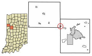
Otterbein is a town in Shelby Township, Tippecanoe County and Bolivar Township, Benton County, Indiana, named for William Otterbein Brown who donated land for the town. As of the 2010 census, its population was 1,262.

<span class="mw-page-title-main">Battle Ground, Indiana</span> Town in Indiana, US

Battle Ground is a town in Tippecanoe Township, Tippecanoe County in the U.S. state of Indiana. The population was 1,334 at the 2010 census. It is near the site of the Battle of Tippecanoe.

<span class="mw-page-title-main">Lafayette, Indiana</span> City in Indiana, US

Lafayette is a city in and is the county seat of Tippecanoe County, Indiana, United States, located 63 miles (101 km) northwest of Indianapolis and 125 miles (201 km) southeast of Chicago. West Lafayette, on the other side of the Wabash River, is home to Purdue University, which contributes significantly to both communities. Together, Lafayette and West Lafayette form the core of the Lafayette metropolitan area, which had a population of 224,709 in the 2021 US Census Bureau estimates.

<span class="mw-page-title-main">West Lafayette, Indiana</span> City in Indiana, United States

West Lafayette is a city in Wabash Township, Tippecanoe County, Indiana, United States, approximately 65 miles (105 km) northwest of the state capital of Indianapolis and 113 miles (182 km) southeast of Chicago. West Lafayette is directly across the Wabash River from its sister city, Lafayette. As of the 2020 census, its population was 44,595. A college town, it is the most densely populated city in Indiana and is home to Purdue University.

Floyds Knobs is a small unincorporated community in Lafayette Township, Floyd County, Indiana, United States. Historically a farming community on the outskirts of New Albany, it has since become a bedroom community for Louisville, Kentucky. It contains subdivisions, farms, small shopping centers, churches, and transmitters for many of the area's television and radio stations. It is also the location of Floyd Central High School. There is a population of about 11,412 to 12,439.

<span class="mw-page-title-main">Indiana's 4th congressional district</span> U.S. House district for Indiana

Indiana's 4th congressional district is a congressional district in the U.S. state of Indiana. From 2003 to 2013 the district was based primarily in the central part of the state, and consisted of all of Boone, Clinton, Hendricks, Morgan, Lawrence, Montgomery, and Tippecanoe counties and parts of Fountain, Johnson, Marion, Monroe, and White counties. The district surrounded Indianapolis including the suburban area of Greenwood and encompassed the more exurban areas of Crawfordsville and Bedford, as well as the college town of Lafayette-West Lafayette, containing Purdue University.

<span class="mw-page-title-main">Wabash Township, Tippecanoe County, Indiana</span> Township in Indiana, United States

Wabash Township is one of thirteen townships in Tippecanoe County, Indiana, United States. As of the 2010 census, its population was 59,279 and it contained 21,448 housing units making it the most populous township in Tippecanoe County.

<span class="mw-page-title-main">Buck Creek, Indiana</span> Census-designated place in Indiana, United States

Buck Creek is an unincorporated census-designated place in Washington Township, Tippecanoe County, in the U.S. state of Indiana.

<span class="mw-page-title-main">Montmorenci, Indiana</span> Census-designated place in Indiana, United States

Montmorenci is an unincorporated census-designated place in Shelby Township, Tippecanoe County, Indiana. Older maps sometimes spell the name Montmorency or Montmorencie.

<span class="mw-page-title-main">Granville, Indiana</span> Ghost town in Indiana, United States

Granville is a former town in Wayne Township, Tippecanoe County, in the U.S. state of Indiana.

<span class="mw-page-title-main">Shelby Township, Tippecanoe County, Indiana</span> Township in Indiana, United States

Shelby Township is one of thirteen townships in Tippecanoe County, Indiana, United States. As of the 2010 census, its population was 2,352 and it contained 920 housing units.

<span class="mw-page-title-main">Wayne Township, Tippecanoe County, Indiana</span> Township in Indiana, United States

Wayne Township is one of thirteen townships in Tippecanoe County, Indiana, United States. As of the 2010 census, its population was 1,580 and it contained 623 housing units.

References

  1. "2020 U.S. Gazetteer Files". United States Census Bureau. Retrieved March 16, 2022.
  2. 1 2 3 U.S. Geological Survey Geographic Names Information System: West Point, Indiana
  3. "USPS.com-Location Details". USPS.com. Retrieved February 4, 2015.
  4. DeHart, R.P. "History of Wayne Township, Tippecanoe County, Indiana From: Past and Present of Tippecanoe County, Indiana". Ray's Place. Retrieved February 5, 2015.
  5. "Tippecanoe County Township Histories: Wayne Township". Tippecanoe County INGenWeb. Retrieved February 5, 2015.
  6. "Tippecanoe County". Jim Forte Postal History. Retrieved July 25, 2016.
  7. "Census of Population and Housing". Census.gov. Retrieved June 4, 2016.
  8. "Indiana High School consolidation database- by county". Indiana Sportswriters and Sportscasters Association. Retrieved February 15, 2015.