West Side Line

Last updated

The West Side Line in Midtown Manhattan, seen in 2013. This opening was permanently covered by residential construction later that year. Empire Connection fr 61 St jeh.jpg
The West Side Line in Midtown Manhattan, seen in 2013. This opening was permanently covered by residential construction later that year.
West Side Line
BSicon numN030.svg
BSicon RP4.svg
BSicon CONTg.svg
BSicon RP4.svg
BSicon HST.svg
BSicon RP4.svg
Riverdale
BSicon STRl.svg
BSicon uSTR.svg
BSicon RP4o.svg
BSicon STRq.svg
BSicon CONTfq.svg
BSicon ueHST.svg
BSicon RP4.svg
Spuyten Duyvil
BSicon WASSERq.svg
BSicon uhKRZWae.svg
BSicon RP4o.svg
BSicon WASSERq.svg
BSicon WASSERq.svg
BSicon ueHST.svg
BSicon RP4.svg
Inwood
BSicon MFADEgq.svg
BSicon hRP4q.svg
BSicon hRP4q.svg
BSicon uSTR.svg
BSicon RP4xRP4.svg
BSicon MFADEfq.svg
BSicon RP4q.svg
BSicon ueHST.svg
BSicon RP4.svg
Fort Washington
BSicon uSTR2.svg
BSicon RP4.svg
BSicon uSTRc3.svg
BSicon MSTR+l.svg
BSicon hRP4+l.svg
BSicon uSTRc1.svg
BSicon MSTRr.svg
BSicon hRP4r.svg
BSicon uSTR+4.svg
BSicon RP4.svg
BSicon ueHST.svg
152nd Street
BSicon RP4.svg
BSicon ueHST.svg
Manhattanville
BSicon RP4.svg
BSicon ueHST.svg
125th Street
(proposed)
BSicon RP4.svg
BSicon utSTRa.svg
BSicon RP4.svg
BSicon POINTERg@fq.svg
BSicon utSTR.svg
BSicon RP4.svg
BSicon uetHST.svg
62nd Street
(proposed)
BSicon RP4.svg
BSicon utSTRe.svg
BSicon POINTERg@fq.svg
BSicon RP4.svg
BSicon uSTR.svg
BSicon lELC.svg
BSicon GRZq.svg
BSicon uSTR.svg
↓ Electrification (Third rail and Overhead line)
BSicon uENDEaq.svg
BSicon uABZgr+r.svg
BSicon utSTRa.svg
BSicon fSTR+l.svg
BSicon uextSTRaq.svg
BSicon uetABZgr.svg
Northern end of High Line
BSicon fSTR.svg
BSicon KDSTaq.svg
BSicon STRq.svg
BSicon utSTR.svg
BSicon CONTfq.svg
BSicon fSTRl.svg
BSicon fSTRq.svg
BSicon utSTRl.svg
BSicon fSTR+r.svg
BSicon utCONTfq.svg
BSicon fENDEe.svg
BSicon uexSTR.svg
Southern end of High Line
BSicon uexKDSTe.svg
St. John's Freight Terminal
(demolished 1927)

BSicon uSTRq.svg
West Side Line, in use
BSicon uexSTRq.svg
West Side Line, abandoned
BSicon STRq.svg
Other railroad lines
BSicon fSTRq.svg
rail trail (the High Line)

The West Side Line, also called the West Side Freight Line, is a railroad line on the west side of the New York City borough of Manhattan. North of Penn Station, from 34th Street, the line is used by Amtrak passenger service heading north via Albany to Toronto; Montreal; Niagara Falls and Buffalo, New York; Burlington, Vermont; and Chicago. South of Penn Station, a 1.45-mile (2.33 km) elevated section of the line, abandoned since 1980, has been transformed into an elevated park called the High Line. The south section of the park from Gansevoort Street to 20th Street opened in 2009 and the second section up to 30th Street opened in 2011, while the final section to 34th Street opened in 2014.

Contents

History

New York City Railroads c. 1900 New York City Railroads ca 1900.png
New York City Railroads c.1900

Hudson River Railroad

Hudson River R.R. St. John's Depot c. 1890 (King1893NYC) pg820 NEW-YORK CENTRAL & HUDSON-RIVER FREIGHT DEPOT ON HUDSON STREET.jpg
Hudson River R.R. St. John's Depot c.1890

The West Side Line was built by the Hudson River Railroad, which completed the forty miles (64 km) to Peekskill on September 29, 1849, opened to Poughkeepsie by the end of that year, and extended to Albany (Rensselaer) in 1851. The city terminus was at the junction of Chambers and Hudson Streets; the track was laid along Hudson, Canal, and West Streets, to Tenth Avenue, which it followed to the upper city station at 34th Street. Over this part of the right-of-way, the rails were laid at grade along the streets, and since the Hudson River Railroad's regulations did not allow locomotives to draw cars through streets, the cars were drawn by a dummy engine. While passing through the city the train of cars was preceded by a man on horseback known as a "West Side cowboy" or "Tenth Avenue cowboy" who gave notice of its approach by blowing a horn. [1] [2]

At 34th Street, the right-of-way curved into Eleventh Avenue, the dummy engine was detached, and the regular locomotive took the train. As far as 60th Street, the track was at street level. The first cut was at Fort Washington Point. The railroad crossed Spuyten Duyvil Creek on a drawbridge; a fatal wreck occurred there on January 13, 1882, when the Atlantic Express, stopped on the line, was rear-ended by a local train, telescoping the last two palace cars, where the stoves and lamps were upset and ignited the woodwork and upholstery. [3]

In 1867, the New York Central Railroad and Hudson River Railroad were united by Cornelius Vanderbilt, being merged in 1869 to form the New York Central and Hudson River Railroad. The railroad acquired the former Episcopal church's St. John's Park property and built a large freight depot at Beach and Varick streets, which opened in 1868. The tracks south to Chambers Street were then removed. [4] In 1871, the Spuyten Duyvil and Port Morris Railroad (Hudson Line) opened, and most passenger trains were rerouted into the new Grand Central Depot via that line along the northeast bank of the Harlem River and the New York and Harlem Railroad (Harlem Line), also part of the New York Central system. The old line south of Spuyten Duyvil remained for freight to the docks along Manhattan's west side and minimal passenger service to the West Side station on Chambers Street (used until 1916).

Grade separation

View from under Henry Hudson Parkway toward maintenance gate to tracks on 82nd Street in Riverside Park Rail entry W82 St snowy jeh.JPG
View from under Henry Hudson Parkway toward maintenance gate to tracks on 82nd Street in Riverside Park

As the city grew, congestion worsened on the west side. Eventually, plans were drawn up for a grade-separated line. The West Side Elevated Highway was built with the line's grade separation in the 1930s. Work on the highway – named for Manhattan Borough President Julius Miller, who championed it – began in 1925, and the first section was dedicated on June 28, 1934. This included a new, elevated eight-track freight terminal called St. John's Terminal, located several blocks north of the old one at St. John's Park, with its southern edge at Spring Street. North of there, an elevated structure (the present-day High Line) carried two tracks north on the west side of Washington Street, curving onto the east side of Tenth Avenue at 14th Street, then crossing Tenth Avenue at 17th Street and heading north along its west side. Just south of the Pennsylvania Station rail yard at 31st–33rd Streets, the line turned west on the north side of 30th Street, then north just east of the West Side Highway. The northernmost bridge crossed 34th Street, and a ramp took it back to Eleventh Avenue south of 35th Street. The elevated line was built through the second or third floors of several buildings along the route; others were served directly by elevated sidings. [5] [6]

In 1937, the tracks along Eleventh Avenue were bypassed by a below-grade line, passing under the 35th Street intersection and running north just west of Tenth Avenue before slowly curving northwest, passing under Eleventh Avenue at 59th Street and rejoining the original alignment. There were three sections that remained open, one at 37th Street, one at 45th Street, and one at 49th Street. The one at 37th Street was covered over in the mid-2010s, but the openings at 45th and 49th Streets remain to this day. [5] [6]

Spuyten Duyvil Bridge, Bronx end, when the swing is open Spuyten Duyvil Bridge north fixed span from gap jeh.jpg
Spuyten Duyvil Bridge, Bronx end, when the swing is open

Around the same time, New York City Parks Commissioner Robert Moses covered the line from 72nd Street north to 120th Street with an expansion of Riverside Park. His project, called the West Side Improvement, was twice as expensive as the Hoover Dam and created the Henry Hudson Parkway, as well as a railroad tunnel under the park. The large 60th Street Yard served as the dividing point between the two-track realignment and a wider four-track line to the north. North of 123rd Street, the line became elevated between the Henry Hudson Parkway and Riverside Drive before returning to the surface and crossing under the Parkway to its west side near 159th Street. It continues along the shore of the Hudson River to the Spuyten Duyvil Bridge, a swing bridge across the Harlem Ship Canal (Spuyten Duyvil Creek), before merging with the Hudson Line just north of the bridge. [6]

In addition to serving the industrial and dock areas of the Lower West Side, the line was the primary route for produce and meat into New York, serving warehouses in the West Village, Chelsea and the Meatpacking District, as well as serving the James Farley Post Office and private freight services. [7]

Donald Trump and Riverside South

Looking north in Riverside Park South. Trump Place and West Side Highway are on the right and 69th Street float transfer bridge on the left. Riverside-south-overview.jpg
Looking north in Riverside Park South. Trump Place and West Side Highway are on the right and 69th Street float transfer bridge on the left.

The New York Central Railroad was merged into Penn Central in 1968. In 1976, the combined Penn Central, following a bankruptcy and then a merger, became the largest part of Conrail. Conrail continued to operate freight along the West Side Line until 1980.

Donald Trump optioned the 60th Street Yard in 1974. [8] Riverside South, the development project he ultimately began there, was then the city's biggest private residential development; it faced opposition from many people living on the Upper West Side. [9] To obtain approval of his project, Trump agreed to substantially reduce the size of his ambitions, [10] build Riverside Park South on 23 acres (9.3 ha) of the yard, [11] and donate the park and the right-of-way for a relocated highway to the city. [12]

The line north of 31st Street was acquired by Amtrak. The southernmost part of the High Line (south of Bank Street) had been removed in the 1960s; [13] the structure from Bank to Gansevoort Streets was removed some 20 years later. [14] The northernmost block of the High Line viaduct, between 34th and 35th Streets, was rerouted to the south of 34th Street in the 1980s because the ramp to 35th Street was demolished as part of the Javits Center's construction. However, the realigned ramp was never used. [15] By mid-2005, the rest of the High Line was owned by CSX, which acquired it after the 1999 breakup of Conrail. [16]

Current usage

Empire Connection

North end of the Empire Connection (right), joining Metro-North's Hudson Line (left) Spuyten Duyvil joint.jpg
North end of the Empire Connection (right), joining Metro-North's Hudson Line (left)

The Empire Connection (or West Side Connection [17] ) allows Amtrak's passenger trains traveling on the Empire Corridor from Albany in upstate New York, and beyond, to enter Penn Station. Before its construction, Empire Service trains came into Grand Central Terminal, requiring passengers bound for Northeast Corridor trains to transfer to Penn Station via shuttle bus, taxicab, subway or on foot. [18] This was a legacy of the fact that the Empire Service lines had previously been part of the New York Central Railroad, which built and owned Grand Central, while Penn Station was owned by the Pennsylvania Railroad. The two stations had never been connected, even after the PRR and New York Central merged as Penn Central in 1968 and after Amtrak took over intercity passenger rail service in 1971.

When the West Side Yard for the Long Island Rail Road was built on the west side of Manhattan in 1986, a tunnel was built under it connecting Penn Station to the West Side Line just west of Eleventh Avenue, near the Javits Center. The project severed the southernmost part of the West Side Line, the High Line viaduct, from the rest of the West Side Line. [19] When additional funding later became available, one track along the northern part of the West Side Line was rebuilt for passenger service and named the Empire Connection. A short section of single track into Penn Station was electrified using third rail and overhead catenary, since diesel locomotives are not allowed in Penn Station's tunnels. North of 39th Street, the single track expands into two tracks and electrification on the line ends. A wye was constructed next to Track 2 (the westernmost track) to allow diesels to turn around. South of 48th Street, there is a crossover from Track 1 (the easternmost track) to Track 2, and another siding splits off Track 2 just south of 48th Street, extending about 300 feet and ending at bumper block at 49th Street. The Empire Connection was double-tracked north of 39th Street to south of the Spuyten Duyvil Bridge in the mid-1990s.

On April 7, 1991, all of Amtrak's trains departing for or arriving from Albany and points north began using the Empire Connection into Penn Station, ending Amtrak service to Grand Central. [20] Transportation planners had long envisioned consolidating all intercity service to New York at Penn Station, but those efforts did not go beyond the planning stages until the 1980s. Besides being more convenient for passengers, many of whom had balked at taking the train to New York City due to the difficulty of transferring between stations, this saved Amtrak the expense of operating two stations in New York City. Additionally, Amtrak had to pay $600,000 per year to the Metropolitan Transportation Authority, operator of Grand Central, to use that station's tracks. [21] [22]

Under the Penn Station Access project, Metro-North Railroad is studying ways it could also serve Penn Station. One alternative being studied would run some Hudson Line commuter trains into Penn Station via the Empire Connection, possibly with new station stops at West 125th and 62nd Streets.

High Line park

A section of the High Line at Tenth Avenue and 17th Street Highline NYC 3705376658 529a375621.jpg
A section of the High Line at Tenth Avenue and 17th Street

By the late 1970s, freight traffic on the southern portion of the line had become nearly non-existent. In the early 1980s, the tracks were closed for a significant period of time as the line was reconfigured to accommodate the expansion of the Javits Center. Even after the line reopened, freight traffic never returned, and the elevated viaducts in Manhattan stood abandoned for over thirty years.

The elevated viaducts were transformed into a 1.45-mile-long (2.33 km) elevated linear park and greenway called the High Line starting in 2006 and opening in phases during 2009, 2011, 2014, and 2019. Since opening in June 2009, the High Line has become an icon of American contemporary landscape architecture. The park became a tourist attraction and spurred real estate development in adjacent neighborhoods, increasing real-estate values and prices along the route.

See also

Related Research Articles

<span class="mw-page-title-main">New York Penn Station</span> Major rail hub in New York City

Pennsylvania Station is the main intercity railroad station in New York City and the busiest transportation facility in the Western Hemisphere, serving more than 600,000 passengers per weekday as of 2019. The station is located beneath Madison Square Garden in the block bounded by Seventh and Eighth Avenues and 31st and 33rd Streets and in the James A. Farley Building, with additional exits to nearby streets, in Midtown Manhattan. It is close to several popular Manhattan locations, including Herald Square, the Empire State Building, Koreatown, and Macy's Herald Square.

<span class="mw-page-title-main">New York Central Railroad</span> American Class I railroad (1853–1968)

The New York Central Railroad was a railroad primarily operating in the Great Lakes and Mid-Atlantic regions of the United States. The railroad primarily connected greater New York and Boston in the east with Chicago and St. Louis in the Midwest, along with the intermediate cities of Albany, Buffalo, Cleveland, Cincinnati, Detroit, Rochester and Syracuse. New York Central was headquartered in New York City's New York Central Building, adjacent to its largest station, Grand Central Terminal.

<i>Empire Service</i> Amtrak service between New York City, NY and Niagara Falls, NY

The Empire Service is an Inter-city rail service operated by Amtrak within the state of New York in the United States. The brand name originated with the New York Central Railroad in 1967. Trains on the line provide frequent daily service along the 460-mile (740 km) Empire Corridor between New York City and Niagara Falls via Albany, the state capital.

<span class="mw-page-title-main">Spuyten Duyvil station</span> Metro-North Railroad station in the Bronx, New York

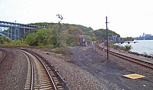
Spuyten Duyvil station is a commuter rail stop on the Metro-North Railroad's Hudson Line, serving the Spuyten Duyvil neighborhood of the Bronx, New York City.

<span class="mw-page-title-main">Marble Hill station</span> Metro-North Railroad station in Manhattan, New York

Marble Hill station is a commuter rail stop on the Metro-North Railroad's Hudson Line, serving the Marble Hill neighborhood of The Bronx in New York City. The station is located at 125 West 225th Street, two blocks west of the Broadway Bridge on the north side of the Harlem River, near the New York City Subway's Marble Hill–225th Street station.

Spuyten Duyvil may refer to:

<i>Adirondack</i> (train) Amtrak service between New York City, NY and Montreal, QC

The Adirondack is an intercity rail passenger train operated daily, partially along the Empire Corridor, by Amtrak between New York City and Montreal. Trains take approximately 11 hours to travel the 381 miles (613 km) route through the scenic Hudson Valley and along the eastern border of the Adirondack Mountains. Operation of the Adirondack is supported by the New York State Department of Transportation and Via Rail. Service was suspended in March 2020 due to the closure of the Canada–United States border in response to the COVID-19 pandemic, resumed in spring 2023, and suspended again at the end of June 2023 because of track conditions in Canada. Service again resumed in September. Amtrak reported that Adirondack served 26,892 passengers in fiscal year 2023, down from pre-COVID-19 pandemic ridership of 117,490 in FY2019.

The New York and Harlem Railroad was one of the first railroads in the United States, and was the world's first street railway. Designed by John Stephenson, it was opened in stages between 1832 and 1852 between Lower Manhattan Island to and beyond Harlem. Horses initially pulled railway carriages, followed by a conversion to steam engines, then on to battery-powered Julien electric traction cars. In 1907, the then leaseholders of the line, New York City Railway, a streetcar operator, went into receivership. Following a further receivership in 1932, the New York Railways Corporation converted the line to bus operation. The Murray Hill Tunnel now carries a lane of road traffic, but not the buses.

<span class="mw-page-title-main">Spuyten Duyvil, Bronx</span> Neighborhood of the Bronx in New York City

Spuyten Duyvil is a neighborhood of the Bronx, New York City. It is bounded on the north by Riverdale, on the east by Kingsbridge, on the south by the Harlem River, and on the west by the Hudson River, although some consider it to be the southernmost part of Riverdale.

<span class="mw-page-title-main">New York Connecting Railroad</span> Freight rail line in New York City

The New York Connecting Railroad or NYCR is a rail line in the borough of Queens in New York City. It links New York City and Long Island by rail directly to the North American mainland. Amtrak, CSX, Canadian Pacific Kansas City, Providence and Worcester Railroad and New York and Atlantic Railway (NYAR) currently use the line. It runs from the Hell Gate Bridge over the East River to Fresh Pond Junction yard in Glendale in Queens. It was completed in 1917. Amtrak uses the northernmost section of the line from Sunnyside Junction in the Woodside section of Queens to the Hell Gate Bridge into the Bronx from which it follows the line north to Boston.

<span class="mw-page-title-main">Empire Corridor</span> Railroad corridor in the U.S. state of New York

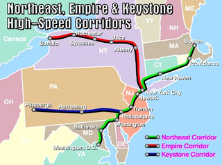
The Empire Corridor is a 461-mile (742 km) passenger rail corridor in New York State running between Penn Station in New York City and Niagara Falls, New York. Major cities on the route include Poughkeepsie, Albany, Schenectady, Amsterdam, Utica, Syracuse, Rochester, and Buffalo. Much of the corridor was once part of the New York Central Railroad's main line.

<span class="mw-page-title-main">34th Street (Manhattan)</span> West-east street in Manhattan, New York

34th Street is a major crosstown street in the New York City borough of Manhattan. It runs the width of Manhattan Island from West Side Highway on the West Side to the FDR Drive on the East Side. 34th Street is used as a crosstown artery between New Jersey to the west and Queens to the east, connecting the Lincoln Tunnel to New Jersey with the Queens–Midtown Tunnel to Long Island.

<span class="mw-page-title-main">Hudson Line (Metro-North)</span> Metro-North Railroad line in New York

The Hudson Line is a commuter rail line owned and operated by the Metro-North Railroad in the U.S. state of New York. It runs north from New York City along the east shore of the Hudson River, terminating at Poughkeepsie. The line was originally the Hudson River Railroad, and eventually became the Hudson Division of the New York Central Railroad. It runs along what was the far southern leg of the Central's famed "Water Level Route" to Chicago.

<span class="mw-page-title-main">Spuyten Duyvil Bridge</span> Bridge between Manhattan and the Bronx, New York

The Spuyten Duyvil Bridge is a railroad swing bridge that spans the Spuyten Duyvil Creek between Manhattan and the Bronx, in New York City. The bridge is located at the northern tip of Manhattan where the Spuyten Duyvil Creek meets the Hudson River, approximately 1,000 feet (300 m) to the west of the Henry Hudson Bridge.

Hudson Line refers to the following rail lines, all originally part of the Hudson River Railroad following the east shore of the Hudson River

<span class="mw-page-title-main">West Side Yard</span> Rail yard in Manhattan, NY, US (opened 1987)

The West Side Yard is a rail yard of 30 tracks owned by the Metropolitan Transportation Authority on the west side of Manhattan in New York City. Used to store commuter rail trains operated by the subsidiary Long Island Rail Road, the 26.17-acre (10.59 ha) yard sits between West 30th Street, West 33rd Street, 10th Avenue and 12th Avenue. Since the early 2010s, the eastern part of the yard has been covered by the Hudson Yards complex of skyscrapers and other buildings.

<span class="mw-page-title-main">Penn Station Access</span> Public works project in New York City

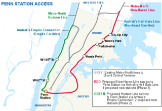
Penn Station Access (PSA) is a public works project underway by the Metropolitan Transportation Authority in New York City. The goal of the project is to allow Metro-North Railroad commuter trains to access Penn Station on Manhattan's West Side, using existing trackage owned by Amtrak. Metro-North trains currently terminate exclusively at Grand Central in Midtown Manhattan.

<span class="mw-page-title-main">Spuyten Duyvil and Port Morris Railroad</span> Former New York railroad company (1842–1871)

Spuyten Duyvil and Port Morris Railroad was a railroad built in what is today the West Bronx and South Bronx in New York City, United States. It ran from the junction between the West Side Line and the Hudson River Railroad near Spuyten Duyvil Creek, then along the Harlem River to the northwestern shore of the East River in what is today the Port Morris section of the Bronx.

<span class="mw-page-title-main">July 2013 Spuyten Duyvil derailment</span> Freight-train accident in the Bronx on commuter rail line

On the evening of July 18, 2013, a CSX freight train carrying municipal solid waste on tracks of the Hudson Line along the Harlem River Ship Canal in the New York City borough of The Bronx partially derailed between the Marble Hill and Spuyten Duyvil stations. While no one was injured, the derailment caused over US$800,000 in damage and took several days to clean up. Commuter rail service by Metro-North Railroad, which owns the line, was suspended for two weekends in order to fully restore normal operations.

<span class="mw-page-title-main">Hell Gate Line</span> Railroad line in New York

The Hell Gate Line is the portion of Amtrak's high-speed Northeast Corridor between Harold Interlocking in Sunnyside, Queens, and Shell Interlocking in New Rochelle, New York, within the New York metropolitan area.

References

Notes

  1. Hudson River and the Hudson River Rail-Road. Boston: Bradbury & Guild. 1851. p. 12. Retrieved September 18, 2015.
  2. "High Line Photo of the Week: West Side Cowboy Twofer". High Line Blog. March 12, 2008. Archived from the original on August 20, 2008.
  3. "Fatal Disaster on the Hudson River Railroad". Frank Leslie's Weekly . January 21, 1882. Retrieved April 10, 2010.
  4. Joint Report of the New York, New Jersey Port and Harbor development Commission, 1917
  5. 1 2 Robbins, L.H. (June 3, 1934). "Transforming the West Side: A Huge Project Marches On". The New York Times.
  6. 1 2 3 "NYC West Side Improvement". railroad.net. Archived from the original on March 1, 2000. Retrieved May 17, 2016.
  7. "New York Central's 1934 West Side Improvement". railroad.net. Archived from the original on April 1, 2016.
  8. Bagli, Charles V. (June 1, 2005). "Trump Group Selling West Side Parcel for $1.8 Billion". The New York Times. Retrieved May 17, 2016.
  9. Weber, Bruce (July 22, 1992). "Debate on Trump's West Side Proposal". The New York Times.
  10. Purdum, Todd S. (March 6, 1991). "Trump Revises Project Plan for West Side". The New York Times.
  11. Vitullo-Martin, Julia (January 19, 2004). "The West Side Rethinks Donald Trump's Riverside South". home.jps.net. Archived from the original on June 4, 2016. Retrieved May 17, 2016.
  12. Finder, Alan (October 22, 1992). "Trump Yields to Demands on Housing". The New York Times.
  13. "The High Line". NYC Architecture.
  14. Amateau, Albert (May 6, 2008). "Newspaper was there at High Line's birth and now its rebirth". The Villager . Vol. 77, no. 48. Archived from the original on April 6, 2012. Retrieved August 12, 2011.
  15. Greenstein, J (April 1, 2002). "WEST SIDE STORY : THE RISE AND FALL OF MANHATTAN'S HIGH LINE". Trains. 62 (3). ISSN   0041-0934 . Retrieved July 10, 2018.
  16. Doyle, Chesney; Spann, Susan (2014). "Elevated Thinking: The High Line in New York City". Great Museums.
  17. "Digging into the Archives: The West Side Connection — Amtrak: History of America's Railroad". history.amtrak.com. Retrieved November 19, 2023.
  18. Penn Station could be reached from the Empire Corridor, but only via an impractical route from the Bronx, via the New Haven Line, that then backtracked several miles to the north, to Pelham Manor, to the Northeast Corridor line.
  19. Voboril, Mary (March 26, 2005). "The Air Above Rail Yards Still Free". Newsday . New York.
  20. "Travel Advisory; Grand Central Trains Rerouted To Penn Station". The New York Times . April 7, 1991. Retrieved February 7, 2010.
  21. Johnson, Kirk (July 7, 1988). "Amtrak Trains To Stop Using Grand Central". The New York Times. Retrieved November 10, 2015.
  22. Barron, James (April 8, 1991). "Riding the Past From Grand Central". The New York Times. Retrieved December 11, 2018.

Sources

KML is not from Wikidata