Westward Ho!

Last updated

Westward Ho!
Westwardho.beach.arp.750pix.jpg
Westward Ho! Beach, looking north towards the Taw and Torridge estuaries
Devon UK location map.svg
Red pog.svg
Westward Ho!
Location within Devon
Population2,112 
OS grid reference SS426291
Civil parish
District
Shire county
Region
Country England
Sovereign state United Kingdom
Post town BIDEFORD
Postcode district EX39
Dialling code 01237
Police Devon and Cornwall
Fire Devon and Somerset
Ambulance South Western
UK Parliament
List of places
UK
England
Devon
51°02′24″N4°14′10″W / 51.040°N 4.236°W / 51.040; -4.236

Westward Ho! is a seaside village near Bideford in Devon, England. The A39 road provides access from the towns of Barnstaple, Bideford, and Bude. It lies at the south end of Northam Burrows and faces westward into Bideford Bay, opposite Saunton Sands and Braunton Burrows. There is an electoral ward with the same name. The population at the 2011 census was 2,112. [1]

Contents

Name

Road sign marking the entrance to the village Westward Ho!.jpg
Road sign marking the entrance to the village

Westward Ho! is noted for its unusual place name. [2] The village name comes from the title of Charles Kingsley's novel Westward Ho! (1855), which was set in nearby Bideford. The book was a bestseller, and entrepreneurs saw the opportunity to develop tourism in the area. The Northam Burrows Hotel and Villa Building Company, chaired by Isaac Newton Wallop, 5th Earl of Portsmouth, was formed in 1863, and its prospectus stated:

This Company has been formed for the erection of a Family Hotel, on an Estate purchased for the purpose immediately contiguous to Northam Burrows, and of Villas and Lodging Houses for Sale or Lease. The want of such accommodation has long been felt, and as no attempt to supply it has hitherto been made by individuals, it is deemed to be a legitimate project to be undertaken by a Company. The salubrity and beauty of the North of Devon have long been known and appreciated. Sir James Clark has placed it in the highest position for health-giving qualities; and the recent publication of Professor Kingsley's "Westward Ho" has excited increased public attention to the western part, more especially, of this romantic and beautiful coast. Nothing but a want of accommodation for visitors has hitherto prevented its being the resort of families seeking the advantages of sea bathing, combined with the invigorating breezes of the Atlantic....

The hotel was named the Westward Ho!-tel, and the adjacent villas were also named after the book. As further development took place, the expanding settlement also acquired the name of Westward Ho! [3] [4] The exclamation mark is therefore an intentional part of the village's name. It is the only such place name in the British Isles; [5] Saint-Louis-du-Ha! Ha!, Quebec, Canada, shares the distinction of having an exclamation mark in its name.

Development

Holy Trinity Church Holy Trinity Church, Westward Ho!.jpg
Holy Trinity Church

Development of the village began ten years after the 1855 Kingsley novel was published, in order to satisfy the Victorians' passion for seaside holidays. [6] The United Services College was founded in the village in 1874.

Shell middens and a submerged forest that date to the Mesolithic period have been excavated on the shoreline at Westward Ho!. [7]

The village has become more residential as holiday camps closed and houses and flats were erected. One former camp was Torville Camp. The two major holiday camps still running are Surfbay Holiday Park and Braddick's Holiday Centre.

United Services College

The United Services College, a public school for boys aged about thirteen to eighteen, was founded at Westward Ho! in 1874 and had the aim of preparing boys for the army and navy and for the service of the British Empire. It lasted until 1906, when it merged with the Imperial Service College in Berkshire and closed its site at Westward Ho!. Notable old boys included Rudyard Kipling, whose book Stalky & Co. (1899) is based on his time at the College.

Geography

The pebble ridge at Westward Ho! beach Detail of the Pebble Ridge at Westward Ho! Beach.jpg
The pebble ridge at Westward Ho! beach

Westward Ho! is known for its surfing seas and the long expanse of clean sand backed by a pebble ridge and grasslands which extends for about three miles. It has two churches, Westward Ho! Baptist Church and Holy Trinity Church.

The seaward part of the village lies within the North Devon Coast, an Area of Outstanding Natural Beauty.

Geology

The rocks on the coastline of Westward Ho! are of Upper Carboniferous age. The rocks were tilted during the Variscan Orogeny; in the present day they dip at 50–70 degrees north and south. The wave-cut platform is an example of a multi-scale fault system, with the phases of tectonic activity exposed at low tide.

Transport

Bus services

Railway

A railway served Westward Ho! from 1901 to 1917. The Bideford, Westward Ho! and Appledore Railway was a standard gauge railway which ran between these places, but had no connection with the rest of the railway system, though there was a pedestrian ferry link from Appledore to Instow which was connected to the rest of the rail network of Britain. A section of the trackbed is used as part of the South West Coast Path.

The Charles Kingsley statue in nearby Bideford Kingsley and Wonky Conker - Bideford (2006-03-04).jpg
The Charles Kingsley statue in nearby Bideford

The West Country class locomotive number 21C136 (later 34036), built initially for Southern Railways and later British Rail, was named "Westward Ho!" after the town.

Sports

It is also known for the Royal North Devon Golf Club, the oldest golf course in England and Wales. Other attractions of the village include the arcades, a go-kart track and the Rock Pool a tidal lido.

World War II

Adapted Bailey bridges were tested at Westward Ho! as part of the Mulberry Harbour project, as well as the Panjandrum by the Directorate of Miscellaneous Weapons Development. [9]

Notable resident

Rudyard Kipling spent several of his childhood years at Westward Ho!, where he attended the United Services College (later absorbed by Haileybury College, which is now in Hertfordshire). His collection of stories, Stalky & Co , published in 1899, was based on his experiences at the College. To commemorate his living there, the first stanza of his poem "If—" is set into the pavement on the promenade in granite setts. [10]

The view inland WestwardHo.jpg
The view inland

Twin towns

Westward Ho! is twinned with Mondeville in France, and Büddenstedt in Germany.

The town lends its name to the song "Westward Ho! - Massive Letdown" by the band Half Man Half Biscuit which recounts a dream about holidaying in the town. The song also mentions the nearby Town of Northam. [11]

See also

Related Research Articles

<span class="mw-page-title-main">Bideford</span> Town in Devon, England

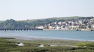
Bideford is a historic port town on the estuary of the River Torridge in north Devon, south-west England. It is the main town of the Torridge local government district.

<span class="mw-page-title-main">United Services College</span> Defunct public school in England

The United Services College was an English boys' public school for the sons of military officers and civil servants, located from 1874 at Westward Ho! near Bideford in North Devon, from 1904 at Harpenden, Hertfordshire, and finally at Windsor, Berkshire. Almost all boys were boarders. The school was founded to prepare pupils for a career as officers in the armed services, many of them going on to the Royal Military College, Sandhurst, or the Royal Naval College, Dartmouth.

<span class="mw-page-title-main">Braunton</span> Village in Devon, England

Braunton is a large village, civil parish, ecclesiastical parish and former manor in Devon. The village is situated 5 miles (8 km) west of Barnstaple. It is one of the largest villages in Devon with a population at the 2021 census of 10,217 people. There are two electoral wards. Their joint population at the above census was 8,218. Within the parish is the fertile, low-lying Braunton Great Field, which adjoins the undulating Braunton Burrows, the Core Area in North Devon Biosphere Reserve, the largest psammosere in England. It confronts the Atlantic Ocean at the west of the parish at the large beach of Saunton Sands, one of the South West's international-standard surfing beaches.

<span class="mw-page-title-main">Northam, Devon</span> Town in Devon, England

Northam is a market town, civil parish and electoral ward in Devon, England, lying north of Bideford. The civil parish also includes the villages of Westward Ho!, Appledore, West Appledore, Diddywell, Buckleigh and Silford, and the residential areas of Orchard Hill and Raleigh Estate.

<span class="mw-page-title-main">Appledore, Torridge</span> Village in Devon, England

Appledore is a village at the mouth of the River Torridge, about 6 miles (10 km) west of Barnstaple and about 3 miles (5 km) north of Bideford in the county of Devon, England. It is the home of Appledore Shipbuilders, a lifeboat slipway and Hocking's Ice Cream, a brand of ice cream only sold in North Devon. There are numerous shops, cafes and galleries. The local football club is Appledore F.C. The ward population at the 2011 census increased to 2,814.

<span class="mw-page-title-main">Clovelly</span> Village in Devon, England

Clovelly is a privately owned harbour village in the Torridge district of Devon, England. The settlement and surrounding land belongs to John Rous who inherited it from his mother in 1983. He belongs to the Hamlyn family who have managed the village since 1738.

<span class="mw-page-title-main">Instow</span> Village in North Devon, England

Instow is a village in north Devon, England. It is on the estuary where the rivers Taw and Torridge meet, between the villages of Westleigh and Yelland and on the opposite bank to Appledore. There is an electoral ward with the same name. The ward's total population at the 2011 census was 1,501.

<span class="mw-page-title-main">Tarka Trail</span> Series of foot and cyclepaths in England

The Tarka Trail is a series of footpaths and cyclepaths around north Devon, England that follow the route taken by the fictional Tarka the Otter in the book of that name. It covers a total of 180 miles (290 km) in a figure-of-eight route, centred on Barnstaple.

<span class="mw-page-title-main">Abbotsham</span> Village in Devon, England

Abbotsham is a village and civil parish in the English county of Devon. In 2001 its population was 434 increasing at the 2011 census to 489.

<span class="mw-page-title-main">Bideford, Westward Ho! and Appledore Railway</span> Former railway in northwest Devon, England

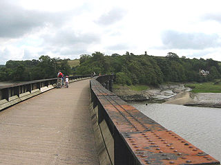
The Bideford, Westward Ho! and Appledore Railway was a railway running in northwest Devon, England. It is unusual in that although it was built as a standard gauge 4 ft 8+12 in line, it was not joined to the rest of the British railway network, despite the London and South Western Railway having a station at Bideford East-the-Water, just on the other side of the river Torridge from the main town. The line was wholly situated on the peninsula made up of Westward Ho!, Northam and Appledore with extensive sand dunes by the Torridge and Taw estuary. The line opened in stages between 1901 and 1908, but closed in 1917, having been requisitioned by the War Office. Re-opening the line after World War I was considered, but dismissed as a viable option. The B.WH!&A.R. was the only railway company in the British Isles to have an exclamation mark in its company title.

<span class="mw-page-title-main">North Devon Football League</span> Association football league in England

The North Devon Football League is a football competition based in England, established in 1904. The top division of this league, the Premier Division, operates at level 12 of the English football league system and has been a feeder to the Devon Football League since 2019, and previously, the South West Peninsula League. The North Devon Gazette sponsors the league and so the full, sponsored name of the league is the North Devon Gazette Football League.

<span class="mw-page-title-main">North Devon Coast</span> Area of Outstanding Natural Beauty in England

The North Devon Coast is a designated Area of Outstanding Natural Beauty in Devon, England, designated in September 1959. The AONB contributes to a family of protected landscapes in the Southwest of England and a total of 38% of the region is classified by the International Union for Conservation of Nature as Category V Protected Landscapes. The twelve Areas of Outstanding Natural Beauty extend to 30% of the region, twice the proportion covered by AONBs in England as a whole and a further two National Parks, Dartmoor and Exmoor, cover an additional 7%.

<span class="mw-page-title-main">Westward Ho! railway station</span> Disused railway station in Devon, England

Westward Ho! railway station was a railway station in north Devon, north-west of Bideford, serving the village of Westward Ho!; a tourist community within the parish of Bideford.

<span class="mw-page-title-main">Northam railway station (Devon)</span> Former railway station in England

Northam railway station was a railway station on the Bideford, Westward Ho! and Appledore Railway in north Devon, close to Appledore. The station served the village of Northam, Parish of Northam, a community within the Appledore peninsula. It was 5 miles 45 chains from Bideford.

<span class="mw-page-title-main">Bideford Bay</span>

Bideford Bay, also known as Barnstaple Bay and often shown on maps as Barnstaple or Bideford Bay, is a large area of water on the northwest coast of Devon in South West England, at the southwestern end of the Bristol Channel where it joins the Celtic Sea. The bay extends from Hartland Point in the southwest to Baggy point the northeast, and is partly sheltered by the island of Lundy, 12 miles (19 km) offshore. It takes its alternative names from the towns of Bideford and Barnstaple, located respectively on the rivers Torridge and Taw which flow into the bay. The alternative spelling Barnstable Bay, in use long after that spelling became obsolete for the town, is also sometimes seen.

<span class="mw-page-title-main">Lovers' Lane Halt railway station</span> Former railway station in Devon, England

Lovers' Lane Halt railway station was a minor railway station or halt in north Devon close to the town of Appledore, a community lying on the peninsula formed by the sea, the River Torridge, and the River Taw.

<span class="mw-page-title-main">Richmond Road Halt railway station</span> Former railway station in Devon, England

Richmond Road Halt was a minor railway station or halt in north Devon, situated fairly close to the town of Appledore, a community lying on the peninsula formed by the sea, the River Torridge, and the River Taw.

<span class="mw-page-title-main">Cornborough railway station</span> Disused railway station in Devon, England

Cornborough railway station was a minor railway station or halt/request stop in north Devon, close to Westward Ho!, serving holiday makers visiting the cliff walks and nearby beach. It lay 3 miles and 30 chains from Bideford Quay.

<span class="mw-page-title-main">North Devon's Biosphere Reserve</span> UNESCO biosphere reserve in North Devon, England

North Devon's Biosphere Reserve is a UNESCO biosphere reserve in North Devon. It covers 55 square miles (140 km2) and is centred on Braunton Burrows, the largest sand dune system (psammosere) in England. The boundaries of the reserve follow the edges of the conjoined catchment basin of the Rivers Taw and the Torridge and stretch out to sea to include the island of Lundy. The biosphere reserve is primarily lowland farmland, and includes many protected sites including 63 Sites of Special Scientific Interest which protect habitats such as culm grassland and broadleaved woodlands. The most populous settlements in its buffer area are Barnstaple, Bideford, Northam, Ilfracombe, and Okehampton.

References

  1. "Ward population 2011" . Retrieved 16 February 2015.
  2. Symons, Mitchell (8 November 2012). The Bumper Book For The Loo: Facts and figures, stats and stories – an unputdownable treat of trivia. Transworld. p. 272. ISBN   978-1-4481-5271-1.
  3. Devon History Society, The ochidore and Westward Ho!
  4. Westward Ho! History Group: Westward Ho! - The Beginning [ permanent dead link ]
  5. Owen-Jones, Peter (11 February 2007). "A wild West country walk" . The Sunday Times . London. Retrieved 5 October 2017. Westward Ho! is an invigorating starting point, because it's the only place in the British Isles with an exclamation mark.
  6. Kingsley, Charles (1855), Westward ho!, or, The voyages and adventures of Sir Amyas Leigh : knight, of Burrough, in the county of Devon, in the reign of Her Most Glorious Majesty Queen Elizabeth, Library of English literature, LEL 21079-80., Macmillan, OCLC   8813367
  7. Smith, P.; et al. (1983), "The investigation of a medieval shell midden in Braunton Burrows", Proceedings of the Devon Archaeological Society, 41, Devon Archaeological Exploration Society: 75–80, OCLC   220919032
  8. https://www.stagecoachbus.com/timetable-pdf?ServiceId=XDAO021.O
  9. J.Evans, R.Walter, E.Palmer, 'A Harbour Goes To War: The Story Of Mulberry And The Men Who Made It Happen'. Publisher - South Machars Historical Society (2000), ISBN   1-873547-30-7. p. 37.
  10. Mason, Nina (5 December 2016). "SureSet: 'If' by Rudyard Kipling for Westward Ho!". Pro Landscaper. Retrieved 13 October 2020.
  11. "Urge for Offal - Westwood Ho!". 28 December 2015. Retrieved 25 December 2015.