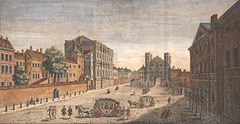
The Palace of Whitehall previously occupied the area and was the residence of Kings Henry VIII through to William III, before it was destroyed by fire in 1698; only the Banqueting House has survived. Whitehall was originally a wide road that led to the gates of the palace; the route to the south was widened in the 18th century, following the destruction of the palace, and the area was largely rebuilt for government offices.
As well as government buildings, the street is known for its memorial statues and monuments, including the UK's primary war memorial, the Cenotaph. South of the Cenotaph the thoroughfare becomes Parliament Street. The Whitehall Theatre (now the Trafalgar Studios) was formerly associated with a series of farces.
Geography and name
The name Whitehall was used for several buildings in the Tudor period.[2] It either referred to a building made of light stone, or as a general term for any festival building. This included the Royal Palace of Whitehall, which in turn gave its name to the street.[3]
The nearest tube stations are Charing Cross at the north end, and Westminster at the south. Numerous London bus routes run along Whitehall, including 12, 24, 88, 159 and 453.[4]
There has been a route connecting Charing Cross to Westminster since the Middle Ages; the 12th-century historian William Fitzstephen described it as "a continued suburb, mingled with large and beautiful gardens, and orchards belonging to the citizens".[5] The name Whitehall was originally only used for the section of road between Charing Cross and Holbein Gate; beyond this it was known as The Street as far as King Street Gate, then King Street thereafter. It had become a residential street by the 16th century, and had become a popular place to live by the 17th, with residents including Lord Howard of Effingham and Edmund Spenser.[2][6]
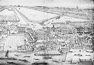
The Palace of Whitehall, to the east of the road, was originally named York Palace, but was renamed during the reign of Henry VIII.[lower-alpha 1] The palace was redesigned in 1531–32 and became the King's main residence later in the decade. He married Anne Boleyn here in 1533, followed by Jane Seymour in 1536, and died at the palace in 1547. Charles I owned an extensive art collection at the palace[3] and several of William Shakespeare's plays had their first performances here.[8] It ceased to be the royal residence after 1689, when William III moved to Kensington Palace for his health to escape what had become dense urban surroundings. The palace was damaged by fire in 1691, following which the front entrance was redesigned by Sir Christopher Wren. In 1698, most of the vast palace burned to the ground accidentally after a fire started by a careless washerwoman.[3]
Wallingford House was constructed in 1572 by William Knollys, 1st Earl of Banbury along the western edge of Whitehall.[9] The Duke of Buckingham bought the house in 1622,[10] and it was subsequently used by Charles I. During the reign of William III, it was bought for the Admiralty.[11] The Old Admiralty Buildings now sit on the house's site.[9]
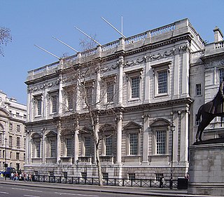
Banqueting House was built as an extension to the Palace of Whitehall in 1622 by Inigo Jones. It is the only surviving portion of the palace after it was burned down, and was the first Renaissance building in London.[12] It later became a museum to the Royal United Services Institute and has been opened to the public since 1963.[13]
Oliver Cromwell moved to the street in 1647, taking up residence in Wallingford House.[11] Two years later, Charles I was carried through Whitehall on the way to his trial at Westminster Hall. Whitehall itself was a wide street and had sufficient space for a scaffold to be erected for the King's execution at Banqueting House.[2] He made a brief speech there before being beheaded.[14][lower-alpha 2] Cromwell died at the Palace of Whitehall in 1658.[3]
During the Great Plague of London in 1665, people boarded coaches at Whitehall, then at the edge of urban London, in an attempt to escape. The King and court temporarily moved to Oxford to avoid the plague, while Samuel Pepys remarked in his diary on 29 June, "By water to Whitehall, where the Court is full of waggons and people ready to go out of town. This end of town every day grows very bad with plague".[16]
By the 18th century, traffic was struggling along the narrow streets south of Holbein Gate, which led to King Street Gate being demolished in 1723. Holbein Gate, in turn, was demolished in 1759. Meanwhile, Parliament Street was a side road alongside the palace, leading to the Palace of Westminster. After the Palace of Whitehall was destroyed, Parliament Street was widened to match Whitehall's width.[17] The present appearance of the street dates from 1899 after a group of houses between Downing Street and Great George Street were destroyed.[2]
On 8 March 1973, the IRA detonated a bomb in front of the Ministry of Agriculture building in Whitehall, injuring a number of bystanders.[18] On 7 February 1991, the IRA launched a mortar attack on 10 Downing Street in an unsuccessful attempt to assassinate Prime Minister John Major and his cabinet.
Government buildings
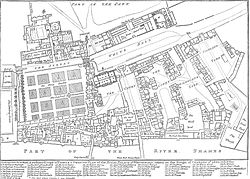
Map of Whitehall and surrounding streets, showing government buildings
By the time the palace was destroyed, separation of crown and state had become important, with Parliament being necessary to control military requirements and pass laws. The government wanted to be some distance from the monarch, and the buildings around Whitehall, physically separated from St James's Palace by St James's Park, seemed to be a good place for ministers to work.[19]
The Horse Guards building was designed by William Kent, and built during the 1750s on a former tiltyard site, replacing an earlier guard-house erected during the Civil War. The building includes an archway for coach traffic and two pedestrian arches that provide access between Whitehall and Horse Guards Parade. The central archway is marked with "SMF" and "StMW", and denotes the boundary between St Martin-in-the-Fields and St Margaret's church parish boundaries.[20]
Scotland Yard, the headquarters of London's Metropolitan Police Service, was originally located in Great Scotland Yard off the north-eastern end of Whitehall. The buildings had been lodgings for the Kings of Scotland, on part of the old Palace of Whitehall's grounds; by the 19th century, Little and Middle Scotland Yard had been merged into Whitehall Place, leaving only Great Scotland Yard. No.4 Whitehall Place had become vacant by the 1820s, which allowed Sir Robert Peel to use it as the main headquarters when forming the police in 1829. It was formally named the Metropolitan Police Office, but became quickly known as Great Scotland Yard, and eventually Scotland Yard. The buildings were damaged in a series of bombings by Irish Nationalists in 1883, and an explosion from a Fenian terrorist attack on 30 May 1884 blew a hole in Scotland Yard's outer wall and destroyed the neighbouring Rising Sun pub. The headquarters was moved away from Whitehall in 1890.[23]
Downing Street leads off the south-west end of Whitehall, just above Parliament Street. It was named after Sir George Downing, who built a row of houses along the street around 1680 leading west from Whitehall. Following a number of terrorist attacks, the road was closed to the public in 1990, when security gates were erected at both ends. On 7 February 1991, the Provisional IRAfired mortars from a van parked in Whitehall towards No.10, one of which exploded in the gardens.[24][25]
Additional security measures have been put in place along Whitehall to protect government buildings, following a £25 million streetscape project undertaken by Westminster City Council. The project has provided wider pavements and better lighting, along with installing hundreds of concrete and steel security barriers.[26]
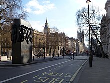
Whitehall, looking north in 1953, with the Earl Haig Memorial in the middle of the carriageway.
Statues and memorials have been built on and around Whitehall, commemorating military victories and leaders. The Cenotaph was designed by Sir Edwin Lutyens and erected at the southern end in 1919, commemorating victory in World War I and later used as a memorial for both World Wars. It is the main war memorial in Britain and an annual service is held here on Remembrance Sunday, led by the reigning monarch and leading politicians.[28] In 2005, a national Monument to the Women of World War II was erected a short distance north of the Cenotaph in the middle of the Whitehall carriageway.[29]
The Royal Tank Regiment Memorial is at the north east end of Whitehall, where Whitehall Court meets Whitehall Place. Erected in 2000, it commemorates the use of tanks in both World Wars and depicts five World War II tank crew members. The Gurkha Memorial is to the south of this, on Horse Guards Avenue to the east of Whitehall.[30]
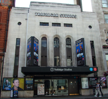
The Whitehall Theatre opened in 1930 at the north west end of the street, on a site that had previously been Ye Old Ship Tavern in the 17th century. The revue Whitehall Follies opened in 1942, which drew controversy over its explicit content featuring the stripper and actress Phyllis Dixey. The theatre became known for its series of farces, reviving a tradition on Whitehall that had begun with court jesters at the palace during the 16th century; these included several plays featuring actor-managerBrian Rix throughout the 1950s and '60s, and 1981's satirical Anyone for Denis, written by John Wells and Private Eye editor Richard Ingrams.[34] The venue was Grade II listed in 1996 and renamed the Trafalgar Studios in 2004.[35]
Because of its importance as the centre of the British government, several political comedies are based in and around Whitehall. These include the BBC television series Yes Minister and The Thick of It.[36]
Whitehall is one of three purple squares on the British Monopoly board, along with Pall Mall and Northumberland Avenue. All three streets converge at Trafalgar Square.[8]
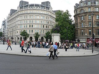
Charing Cross is a junction in Westminster, London, England, where six routes meet. Since the early 19th century, Charing Cross has been the notional "centre of London" and became the point from which distances from London are measured. Clockwise from north, the routes that meet at Charing Cross are: the east side of Trafalgar Square leading to St Martin's Place and then Charing Cross Road; the Strand leading to the City; Northumberland Avenue leading to the Thames Embankment; Whitehall leading to Parliament Square; The Mall leading to Admiralty Arch and Buckingham Palace; and two short roads leading to Pall Mall.
The Mall is a ceremonial route and roadway in the City of Westminster, central London, that travels 1 kilometre (0.62 mi) between Buckingham Palace at its western end and Trafalgar Square via Admiralty Arch to the east. Along the north side of The Mall is green space and St. James's Palace with other official buildings, and to the south is St James's Park. Near the east end at Trafalgar Square and Whitehall it is met by Horse Guards Road and Spring Gardens, near the west end at the Victoria Memorial it is met by the Constitution Hill roadway and the Spur Road to the street of Buckingham Gate. It is closed to traffic on Saturdays, Sundays, public holidays and on ceremonial occasions.
The Palace of Whitehall – also spelled White Hall – at Westminster was the main residence of the English monarchs from 1530 until 1698, when most of its structures, with the notable exception of Inigo Jones's Banqueting House of 1622, were destroyed by fire. Henry VIII moved the royal residence to White Hall after the old royal apartments at the nearby Palace of Westminster were themselves destroyed by fire. Although the Whitehall palace has not survived, the area where it was located is still called Whitehall and has remained a centre of the British government.
The Marble Arch is a 19th-century white marble-faced triumphal arch in London, England. The structure was designed by John Nash in 1827 as the state entrance to the cour d'honneur of Buckingham Palace; it stood near the site of what is today the three-bayed, central projection of the palace containing the well-known balcony. In 1851, on the initiative of architect and urban planner Decimus Burton, a one-time pupil of John Nash, the arch was relocated to its current site, near the northeast corner of Hyde Park, so that expansion of Buckingham Palace could proceed.
A number of military citadels are known to have been constructed underground in central London, dating mostly from the Second World War and the Cold War. Unlike traditional above-ground citadels, these sites are primarily secure centres for defence coordination.
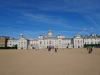
Horse Guards Parade is a large parade ground off Whitehall in central London. It is the site of the annual ceremonies of Trooping the Colour, which commemorates the monarch's official birthday, and the Beating Retreat.
Pall Mall is a street in the St James's area of the City of Westminster, Central London. It connects St James's Street to Trafalgar Square and is a section of the regional A4 road. The street's name is derived from pall-mall, a ball game played there during the 17th century, which in turn is derived from the Italian pallamaglio, literally "ball-mallet".
Horse Guards is a historic building in the City of Westminster, London, between Whitehall and Horse Guards Parade. It was built in the mid-18th century, replacing an earlier building, as a barracks and stables for the Household Cavalry. The current and previous buildings were, between the early 18th century and 1858, the main military headquarters for the British Empire. Horse Guards originally formed the entrance to the Palace of Whitehall and later St James's Palace; for that reason it is still ceremonially defended by the King's Life Guard.
Horse Guards Road is a road in the City of Westminster, London. Located in post code SW1A 2HQ, it runs south from The Mall down to Birdcage Walk, roughly parallel with Whitehall and Parliament Street.
Northumberland Avenue is a street in the City of Westminster, Central London, running from Trafalgar Square in the west to the Thames Embankment in the east. The road was built on the site of Northumberland House, the London home of the Percy family, the Dukes of Northumberland between 1874 and 1876, and on part of the parallel Northumberland Street.
The Banqueting House, on Whitehall in the City of Westminster, central London, is the grandest and best-known survivor of the architectural genre of banqueting houses, constructed for elaborate entertaining. It is the only large surviving component of the Palace of Whitehall, the residence of English monarchs from 1530 to 1698. The building is important in the history of English architecture as the first structure to be completed in the classical style of Palladian architecture which was to transform English architecture.
Great Scotland Yard is a street in Westminster, London, connecting Northumberland Avenue and Whitehall. By the 16th century, this 'yard', which was then a series of open courtyards within the Palace of Whitehall, was fronted by buildings used by diplomatic representatives of the Kingdom of Scotland. In the 19th century, it was a street and open space, which was the location of a public entrance to the original headquarters of the Metropolitan Police Service of London, causing the name "Scotland Yard" to become synonymous with the police service.
Horse Guards Avenue is a road in the City of Westminster, London, linking the major thoroughfares of Whitehall and Victoria Embankment, to the east of the Horse Guards building and parade area. The entrance of the Main Building of the Ministry of Defence (MoD), flanked by its monumental Earth and Water statues, opens onto the Avenue. A statue of a Gurkha soldier, unveiled in 1997, stands as a memorial in front of the Ministry of Defence.
Government Offices Great George Street (GOGGS) is a large UK government office building situated in Westminster between Horse Guards Road, Great George Street, Parliament Street, King Charles Street and Parliament Square. The western end of the building, on Horse Guards Road, is known as 1 Horse Guards Road (1HGR). The Parliament Street end is referred to as 100 Parliament Street (100PS).
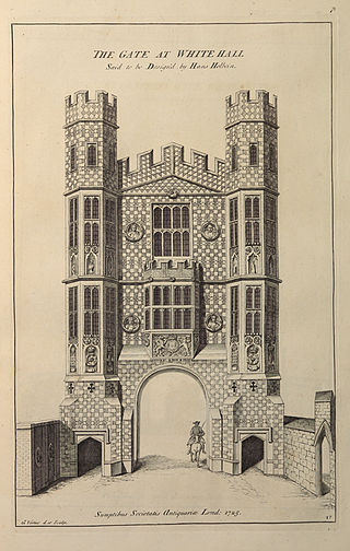
The Holbein Gate was a monumental gateway across Whitehall in Westminster, constructed in 1531–32 in the English Gothic style. The Holbein Gate and a second less ornate gate, Westminster Gate, were constructed by Henry VIII to connect parts of the Tudor Palace of Whitehall to the east and west of the road. It was one of two substantial parts of the Palace of Whitehall to survive a catastrophic fire in January 1698, the other being Inigo Jones's classical Banqueting House. The Holbein Gate was described by Thomas Pennant as "the most beautiful gate at Whitehall". It was demolished in August 1759 to allow better movement of traffic and was possibly going to be re-erected in Windsor Great Park, but its materials were dispersed instead.
The Privy Garden of the Palace of Whitehall was a large enclosed space in Westminster, London, that was originally a pleasure garden used by the late Tudor and Stuart monarchs of England. It was created under Henry VIII and was expanded and improved under his successors, but lost its royal patronage after the Palace of Whitehall was almost totally destroyed by fire in 1698.
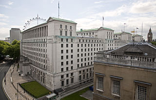
The Ministry of Defence Main Building or MOD Main Building, also known as MOD Whitehall or originally as the Whitehall Gardens Building, is a grade I listed government office building located on Whitehall in London. The building was designed by E. Vincent Harris in 1915 and constructed between 1939 and 1959 on part of the former site of the Palace of Whitehall, specifically Pelham House, Cromwell House, Montagu House, Pembroke House and part of Whitehall Gardens. It was initially occupied by the Air Ministry and the Board of Trade before in 1964 becoming the current home of the Ministry of Defence.
This is a list of the etymology of street names in the London district of Westminster. The Westminster area has no formally defined boundaries - those utilised here are the generally accepted boundaries of: The Mall and Northumberland Avenue to the north, the river Thames and Victoria Embankment/Millbank to the east, Vauxhall Bridge Road to the south and Buckingham Gate, Buckingham Palace Road and Bressenden Place to the west. For convenience Constitution Hill and Spur Road in the Royal Parks, and the area around the Wellington Arch, are included here, as are the streets in the Leicester Square area.
The Admiralty buildings complex lies between Whitehall, Horse Guards Parade and The Mall and includes five inter-connected buildings.
References
Notes
↑ Shakespeare's Henry VIII mentions the name change in Act IV, scene 1: "You must no more call it York Place—that is past: For since the Cardinal fell that title's lost; 'Tis now the King's, and called Whitehall"[7]
↑ The English Civil War Society commemorate the death of Charles I annually on the nearest Sunday to 30 January, the anniversary of the execution. The society retraces the route the King took from St James's Palace to the Banqueting House, where a wreath is laid at the site of the scaffold.[15]
↑ The memorial, designed by Alfred Frank Hardiman and unveiled on 10 November 1937, proved controversial as it took several attempts to design a realistic head and horse. Haig's widow refused to attend the opening ceremony.[31]
↑ John Michael Lee, George William Jones, June Burnham (1998). At the Centre of Whitehall: Advising the Prime Minister and Cabinet. St. Martin's Press. p.42. ISBN0-312-17730-5.{{cite book}}: CS1 maint: multiple names: authors list (link)
↑ "Whitehall". Stone Restoration Services. Retrieved 5 July 2016.
Whitehall Through the Centuries by George S Dugdale (Assistant at the London Museum) with black and white reproductions and plans. A foreword by Sir Edward Bridges. First published by Phoenix House (London) in 1950 with no ISBN.
Stone to Build London: Portland's Legacy, Gill Hackman, Folly Books, Monkton Farleigh, 2014, ISBN978-0-9564405-9-4. Book includes details of many of the Portland stone buildings in Whitehall, including the Cenotaph, Banqueting House, Horse Guards, Foreign and Commonwealth Office and Ministry of Defence.
This page is based on this Wikipedia article Text is available under the CC BY-SA 4.0 license; additional terms may apply. Images, videos and audio are available under their respective licenses.