Willey House (New Hampshire)

Last updated
Drawing by W. H. Bartlett of the Willey House, Crawford Notch. Once the home of Ethan Crawford, it later became a tourist attraction following a storm in 1826 which resulted in the deaths of the Willey family and others. Willey House, Crawford Notch, White Mountains, New Hampshire.png
Drawing by W. H. Bartlett of the Willey House, Crawford Notch. Once the home of Ethan Crawford, it later became a tourist attraction following a storm in 1826 which resulted in the deaths of the Willey family and others.
A stereoscopic slide of the Willey House by Kilburn Brothers, ca. 1872 Willey House, by Kilburn Brothers.jpg
A stereoscopic slide of the Willey House by Kilburn Brothers, ca. 1872

The Willey House at Crawford Notch in the White Mountains of New Hampshire is associated principally with a tragedy of August 28, 1826, in which seven members of the Willey family and two other people died. Out of that event came a boost to the nascent tourism industry of the area.

Contents

Background

The Willey House was originally known as Old Notch House and had been built in 1793. Ethan Crawford acquired it in 1823 for use as an inn to accommodate his growing business as a mountain guide, and in 1826 it was occupied by a family headed by Samuel J. Willey Jr. [1] [2] [3]

1826 disaster

Northern New England experienced a drought in the summer of 1826, which ended with the arrival of a terrific storm on the evening of August 28. Flooding followed, with the valley at Crawford Notch being one place that suffered the consequences. All but two of the bridges on the turnpike that ran through the notch were destroyed, trees suffered a similar fate and the high sides of the valley were gouged by swollen streams and landslides. The Willey House was a scene of desolation due to the effects of an avalanche on a mountain behind it. The house, however, had survived in an island of calm because the surging debris split either side on a low ridge and then unified again beyond it. [1]

Local residents, including Ethan Crawford and the Reverend Benjamin G. Willey, Samuel's brother, visited the house in the aftermath of the storm. It was empty, with signs that there may have been a rapid departure from it, such as unmade beds, clothes strewn around and ashes in the fireplace. [1] There was an open Bible on the table. [3] A search of the devastated area over the next few days revealed the bodies of the Willey parents, two of their daughters and two hired hands; the remains of the other three Willey children were never found. [1] Some livestock had also been killed, including those in a now-destroyed stable. [3]

There followed various theories as to what had happened, the most likely of which is that the occupants abandoned the property as the avalanche approached but in doing so, in darkness, they unwittingly put themselves in the path of it around the point where the flow reunited. [1]

Tourist attraction

News of the disaster spread, initially through many regional newspapers, [1] and also through media such as Theodore Dwight's guidebook, The Northern Traveller. [2] People began to visit the site, drawn to the scene of devastation, human tragedy and the miraculous survival of the structure itself. As well as boosting a nascent tourist industry in the area, in which the Crawford family had already been playing a significant part, it became a source of inspiration for artists and writers. The 4,000-foot (1,200 m) peak on the western wall of the notch became known as Mount Willey. [1]

Dona Brown believes that the artist Thomas Cole and other visitors, such as Nathaniel Hawthorne, used the interest in the tragedy to draw interest to their work, deliberately painting and writing about an area that had suddenly gained national attention. Ethan Crawford, too, exploited it by, for example, ensuring that the Willey House was well signposted. [4] The Crawfords had been directly affected by the storm, with Ethan's property suffering US$1000 of damage and his father's farm being wrecked almost beyond repair, but they were also affected in a positive manner with the subsequent influx of tourists. In 1828, Ethan began construction of a new inn, called the Notch House, at the northern end of the notch, appointing his brother Thomas to run it. The business opened in 1829 and attracted many notable people, including Ralph Waldo Emerson, Hawthorne, Henry David Thoreau and Daniel Webster. [5]

Hawthorne was inspired by the Willey tragedy to write a short story titled "The Ambitious Guest" in 1835, [6] while Cole noted in his diary that "The site of the Willey House, with its little patch of green in the gloomy desolation, very naturally recalled to mind the horrors of the night when the whole family perished beneath an avalanche of rocks and earth." [7]

Horace Fabyan, who was a merchant and a speculator in the emerging tourism industry, took control of the Willey House in 1845 and converted it into a 50-bed hotel. [8] Visitor interest in the effects of the disastrous storm waned over time, despite the efforts of people such as Benjamin Willey to maintain and profit by it by offering guided tours of the house for a fee. It had become old news and nature had taken it course to cover much of the scenic damage. [2]

The site of the house and the landslide is now an interpretive center within Crawford Notch State Park. [9]

See also

Related Research Articles

<span class="mw-page-title-main">Hart's Location, New Hampshire</span> Town in New Hampshire, United States

Hart's Location is a town in Carroll County, New Hampshire, United States. Since 1948, the town has been one of the first places to declare its results for the New Hampshire presidential primary and U.S. presidential elections.

<span class="mw-page-title-main">Crawford's Purchase, New Hampshire</span> Township in Coos County, New Hampshire, United States

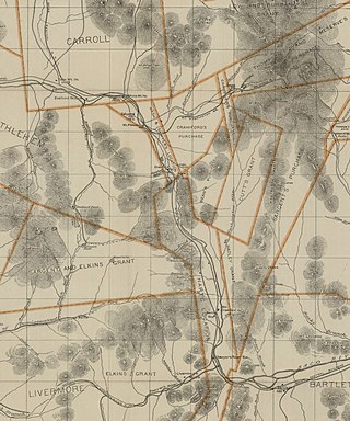
Crawford's Purchase is a township in Coös County, New Hampshire, United States. The purchase lies entirely within the White Mountain National Forest. As of the 2020 census, the purchase had a population of zero.

<span class="mw-page-title-main">Mount Washington</span> Highest mountain in Northeastern United States

Mount Washington, in New Hampshire, is the highest peak in the Northeastern United States at 6,288.2 ft (1,916.6 m) and the most topographically prominent mountain east of the Mississippi River.

<span class="mw-page-title-main">White Mountains (New Hampshire)</span> Mountain range in New Hampshire and Maine, United States

The White Mountains are a mountain range covering about a quarter of the state of New Hampshire and a small portion of western Maine in the United States. They are part of the northern Appalachian Mountains and the most rugged mountains in New England. The range is heavily visited due to its proximity to Boston, New York City, and Montreal.

<span class="mw-page-title-main">Crawford Notch State Park</span> State park in New Hampshire

Crawford Notch State Park is located on U.S. Highway 302, in northern New Hampshire, between Bretton Woods and Bartlett. The 5,775-acre (2,337 ha) park occupies the center of Crawford Notch, a major pass through the White Mountains.

<span class="mw-page-title-main">Crawford Notch</span> Major pass through White Mountains in New Hampshire, US

Crawford Notch is a major pass through the White Mountains of New Hampshire, located in Hart's Location. Roughly half of that town is contained in Crawford Notch State Park. The high point of the notch, at approximately 1,900 feet (580 m) above sea level, is at the southern end of the town of Carroll, near the Crawford Depot train station and Saco Lake, the source of the Saco River, which flows southward through the steep-sided notch. North of the high point of the notch, Crawford Brook flows more gently northwest to the Ammonoosuc River, a tributary of the Connecticut River.

<span class="mw-page-title-main">Bean's Grant, New Hampshire</span> Township in Coos County, New Hampshire, United States

Bean's Grant is a township in southern Coös County, New Hampshire, United States, north of Crawford Notch State Park. The grant lies entirely within the White Mountain National Forest. The population was zero as of the 2020 census.

<span class="mw-page-title-main">White Mountain art</span> 19th-century art depicting New Hampshire, US

White Mountain art is the body of work created during the 19th century by over four hundred artists who painted landscape scenes of the White Mountains of New Hampshire in order to promote the region and, consequently, sell their works of art.

"The Ambitious Guest" is a short story by Nathaniel Hawthorne. First published in The New-England Magazine in June 1835, it was republished in the second volume of Twice-Told Tales in 1841.

<span class="mw-page-title-main">Boott Spur</span>

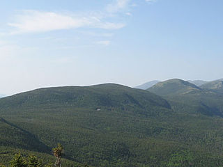
Boott Spur is a minor peak located in Coos County, New Hampshire. The mountain is named after Francis Boott (1792–1863), and is part of the Presidential Range of the White Mountains. Boott Spur stands on the shoulder of Mount Washington, above the south side of the headwall of Tuckerman Ravine.

<span class="mw-page-title-main">Mount Willey</span> Mountain in the state of New Hampshire

Mount Willey is a mountain located in Grafton County, New Hampshire. The mountain is named after Samuel Willey, Jr. (1766–1826) and his family, who in 1825 moved into a house in Crawford Notch. The family was killed a year later in August 1826 during a landslide.

<span class="mw-page-title-main">Mount Tom (New Hampshire)</span>

Mount Tom is a mountain located in Grafton County, New Hampshire, about 1.5 miles (2.4 km) southwest of the height of land of Crawford Notch.

John Wingate Weeks was a U.S. Representative from New Hampshire, great uncle of John Wingate Weeks.

<span class="mw-page-title-main">Crawford House (Crawford Notch, New Hampshire)</span>

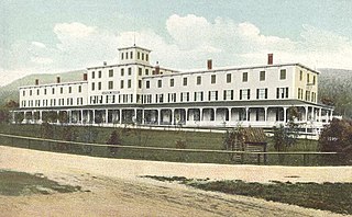
Crawford House was a grand hotel in Crawford Notch, New Hampshire, United States. The original hotel was built in 1850 and destroyed by fire in 1859. It was replaced by a second Crawford House resort that was the largest hotel in the White Mountains at the time. It was further expanded over time to accommodate 400 guests. The hotel featured wide porches and views of Crawford Notch. It eventually fell into disrepair and then closed in 1975. The hotel building was destroyed by fire in November 1977.

<span class="mw-page-title-main">Fabyan House</span> Grand hotel in the United States destroyed by fire in 1951

Fabyan House was a grand hotel in the White Mountains of New Hampshire, constructed by Sylvester Marsh who also built the Mount Washington Cog Railway. The hotel burned during construction in 1868 and was rebuilt in 1873. It was destroyed by fire in 1951.

William Oakes was an American botanist.

<span class="mw-page-title-main">Crawford family of the White Mountains</span> New Hampshire family

The Crawford family of the White Mountains were a family who moved to New Hampshire's White Mountains in the 1790s from Guildhall, Vermont, and were pioneers in establishing a tourist industry in that area. Abel Crawford and his father-in-law, Eleazar Rosebrook, began the effort, and one of Abel's sons, Ethan Allen Crawford, made significant contributions. Another son, Thomas Jefferson Crawford, continued the work; and Ethan's wife, Lucy, also contributed. Their work was in the area then known as White Mountain Notch, subsequently called Crawford Notch.

The History of the White Mountains from the First Settlement of Upper Coos and Pequaket was written by Lucy Crawford and first published in 1846, with a revised and expanded edition written in 1860 but not published until 1966.

<span class="mw-page-title-main">Mount Crawford (New Hampshire)</span>

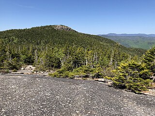
Mount Crawford is a mountain located in Coos County, New Hampshire, in the United States. The mountain is on a spur of Montalban Ridge within the White Mountains and overlooks Crawford Notch. It is accessible via the Davis Path, which climbs from Crawford Notch near the Notchland Inn. The Davis Path continues north up Montalban Ridge to Mount Washington.

<span class="mw-page-title-main">Crawford Path</span> Hiking trail in the White Mountains of New Hampshire

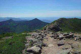
The Crawford Path is an 8.5-mile-long (13.7 km) hiking trail in the White Mountains of New Hampshire that is considered to be the United States' oldest continuously maintained hiking trail. It travels from Crawford Notch to the summit of Mount Washington (Agiocochook). The first iteration of the Crawford Path was cut in 1819 by Ethan Allen Crawford and his father, Abel Crawford. The trail ascends a cumulative 4,900 feet (1,500 m), first through densely wooded forest for about 3.1 miles (5.0 km), then following the exposed southern ridge of the Presidential Range mostly above the treeline.

References

  1. 1 2 3 4 5 6 7 Bennett, Randall H. (2003). The White Mountains: Alps of New England. Arcadia Publishing. pp. 63–68. ISBN   978-0-73852-433-7.
  2. 1 2 3 Avery, Kevin J. (2000). "Selling the Sublime and the Beautiful: Landscape Painting and Tourism". In Voorsanger, Catherine Hoover; Howat, John K. (eds.). Art and the Empire City: New York, 1825–1861. Metropolitan Museum of Art. pp. 115–118. ISBN   978-0-87099-957-4.
  3. 1 2 3 Johnson, Christopher (2006). This Grand & Magnificent Place: The Wilderness Heritage of the White Mountains. UPNE. pp. 55–58. ISBN   978-1-58465-461-2.
  4. Brown, Dona (2014) [1995]. Inventing New England: Regional Tourism in the Nineteenth Century. Smithsonian Institution. pp. 60, 62. ISBN   978-1-58834-430-4.
  5. Johnson, Christopher (2006). This Grand & Magnificent Place: The Wilderness Heritage of the White Mountains. UPNE. pp. 58–59. ISBN   978-1-58465-461-2.
  6. Sears, John F. (October 1982). "Hawthorne's "The Ambitious Guest" and the Significance of the Willey Disaster". American Literature. 54 (3): 354–367. doi:10.2307/2925848. JSTOR   2925848.
  7. Noble, Louis Legrand (1997). The Life and Works of Thomas Cole. Black Dome Press. p. 66. ISBN   978-1-883789-13-8.
  8. Brown, Dona (2014) [1995]. Inventing New England: Regional Tourism in the Nineteenth Century. Smithsonian Institution. p. 65. ISBN   978-1-58834-430-4.
  9. "Crawford Notch State Park". NH Division of Parks and Recreation. Retrieved March 12, 2018.

44°10′56″N71°23′58″W / 44.18222°N 71.39944°W / 44.18222; -71.39944

Further reading