William W. McDonald is an American rancher, and conservationist. He is executive director of the Malpai Borderlands Group. [1] He was a 1998 MacArthur Fellow.
William W. McDonald is an American rancher, and conservationist. He is executive director of the Malpai Borderlands Group. [1] He was a 1998 MacArthur Fellow.
He is the fifth generation on the Sycamore Canyon Ranch, which was homesteaded in 1907. He graduated from Arizona State University and then began managing the ranch full-time. The Sycamore Ranch is in Southeastern Arizona. [2]

Springerville is a town in Apache County, Arizona, United States, within the White Mountains. Its postal ZIP Code is 85938. As of the 2010 census, the population of the town was 1,961.

Badlands are a type of dry terrain where softer sedimentary rocks and clay-rich soils have been extensively eroded. They are characterized by steep slopes, minimal vegetation, lack of a substantial regolith, and high drainage density. Ravines, gullies, buttes, hoodoos and other such geologic forms are common in badlands.
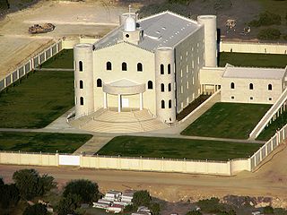
The Fundamentalist Church of Jesus Christ of Latter-Day Saints is a religious sect of the fundamentalist Mormon denominations whose members practice polygamy. The fundamentalist Mormon movement emerged in the early 20th century, when its founding members were excommunicated from The Church of Jesus Christ of Latter-day Saints, largely because of their refusal to abandon the practice of plural marriage after it was renounced in the "Second Manifesto" (1904). The FLDS Church as a distinct group traces its origins to the 1950s in the Short Creek community, where the group is still based.

The Chihuahuan Desert is a desert and ecoregion designation covering parts of northern Mexico and the southwestern United States. It occupies much of West Texas, the middle and lower Rio Grande Valley, the lower Pecos Valley in New Mexico, and a portion of southeastern Arizona, as well as the central and northern portions of the Mexican Plateau. It is bordered on the west by the Sonoran Desert and the extensive Sierra Madre Occidental range, along with northwestern lowlands of the Sierra Madre Oriental range. On the Mexican side, it covers a large portion of the state of Chihuahua, along with portions of Coahuila, north-eastern Durango, the extreme northern part of Zacatecas, and small western portions of Nuevo León. With an area of about 501,896 km2 (193,783 sq mi), it is the largest desert in North America.

Sycamore Valley Ranch, formerly Neverland Ranch or Neverland, is a developed property in Santa Barbara County, California, located at 5225 Figueroa Mountain Road, Los Olivos, California, on the edge of Los Padres National Forest. It was the home and private amusement park of American entertainer Michael Jackson from 1988 until 2005.
The New Alliance Party (NAP) was an American political party formed in New York City in 1979. Its immediate precursor was an umbrella organization known as the Labor Community Alliance for Change, whose member groups included the Coalition of Grass Roots Women and the New York City Unemployed and Welfare Council. These groups were all associated with controversial psychologist and political activist Fred Newman, whose radical healthcare collectives, Centers for Change and Marxist International Workers Party, were active in grassroots politics in New York City.

The Madrean Sky Islands are enclaves of Madrean pine–oak woodlands, found at higher elevations in a complex of small mountain ranges in southern and southeastern Arizona, southwestern New Mexico, and northwestern Mexico. The sky islands are surrounded at lower elevations by the Sonoran and Chihuahuan deserts. The northern west–east perimeter of the sky island region merges into the higher elevation eastern Mogollon Rim and the White Mountains of eastern Arizona.

Joseph Isaac Clanton was a member of a loose association of outlaws known as The Cowboys who clashed with lawmen Wyatt, Virgil and Morgan Earp as well as Doc Holliday. On October 26, 1881, Clanton was present at the Gunfight at the O.K. Corral in the boomtown of Tombstone, Arizona Territory but was unarmed and ran from the gunfight, in which his 19-year-old brother Billy was killed.

Newman Haynes Clanton, also known as "Old Man" Clanton, was a cattle rancher and father of four sons, one of whom was killed during the Gunfight at the O.K. Corral. Two of his sons were involved in multiple conflicts in Cochise County, Arizona Territory including stagecoach robbery and cattle rustling. His son Ike Clanton was identified by one witness as a participant in the murder of Morgan Earp. Billy Clanton and Ike were both present at the Gunfight at the O.K. Corral in which Billy was killed. "Old Man" Clanton was reportedly involved with stealing cattle from Mexican ranchers and re-selling them in the United States. Records indicate he participated in the Skeleton Canyon Massacre of Mexican smugglers. In retaliation, Mexican Rurales are reported to have ambushed and killed him and a crew of Cowboys in the Guadalupe Canyon Massacre.
A movie ranch is a ranch that is at least partially dedicated for use as a set in the creation and production of motion pictures and television shows. These were developed in the United States in southern California, because of the climate. The first such facilities were all within the 30-mile (48 km) studio zone, often in the foothills of the San Fernando Valley, Santa Clarita Valley, and Simi Valley in the U.S. state of California.
Gary Paul Nabhan is an agricultural ecologist, Ethnobotanist, Ecumenical Franciscan Brother, and author whose work has focused primarily on the plants and cultures of the desert Southwest. He is considered a pioneer in the local food movement and the heirloom seed saving movement.
Malpai Borderlands is a region, or areal feature, along the U.S.-Mexico border at the Arizona and New Mexico state line. It encompasses the extreme southeast corner of Arizona and the southwest corner of New Mexico describe the general vicinity. It includes areas inside the U.S. states of Arizona and New Mexico as well as the Mexican states of Chihuahua and Sonora.

Boney Mountain in Ventura County, California is one of the highest peaks in the Santa Monica Mountains. The prominent mountain visible from Newbury Park, California is 2,825 feet (861 m). It is also known as Boney Peak. The mountain contains four of the highest peaks in the coastal range of the Santa Monica Mountains: Boney Peak, Sandstone Peak, Exchange Peak, and Tri Peaks. The highest summit in the Santa Monica Mountains is Sandstone Peak, situated less than a mile northeast of Boney Peak along the same ridge of volcanic rock. It is the top section of a mass of volcanic rock which solidified around 15 million years ago, and was later uplifted to its dominant position, overshadowing western Conejo Valley. The Chumash Native Americans have a long and deeply spiritual history of interaction at and near the mountain, and the peak is considered a sacred mountain to the Chumash people.

Casa Malpaís is an archaeological site of the Ancestral Puebloans located near the town of Springerville, Arizona. The site is a nationally recognized archaeological site and was declared a National Historic Landmark in 1964.
The Animas Mountains are a small mountain range in Hidalgo County, within the "Boot-Heel" region of far southwestern New Mexico, in the United States. They extend north–south for about 30 miles (50 km) along the Continental Divide, from near the town of Animas to a few miles north of the border with Mexico. The range is about 12 miles (20 km) wide at its widest. The highest point of the range is the southern summit of the mile-long Animas Peak massif, 8,565 feet (2,611 m). The Animas Mountains lie between the Animas Valley on the west and the Playas Valley on the east. Nearby ranges include the Peloncillo Mountains, across the Animas Valley, and the Big Hatchet and Little Hatchet Mountains, across the Playas Valley. Physiographically, the range divides into two parts. The compact southern part, which includes Animas Peak, is higher and wider, rising up to 4,000 ft above the nearby valleys. It has a sky island character, with dense coniferous forests at the higher elevations. The longer, narrow northern portion is lower, reaching only 7,310 ft at Gillespie Peak, and is characterized by grassland and piñon-juniper woods and shrubs. The Animas Mountains lie near the Chihuahuan Desert, the Sonoran Desert, the Sierra Madre Occidental of Mexico, and the mountains surrounding the headwaters of the Gila River. Biotic influences from these regions, as well as the more distant Rocky Mountains, give the southern portion of the range a great diversity of species, including "approximately 130 species of birds, 60 species of mammals, and 40 species of reptiles."

Malpaís, in the Southwestern United States, Spain, Mexico, and other Spanish-speaking regions, are rough and barren landscapes that consist of relict and largely uneroded lava fields exhibiting recognizable lava flows, volcanic cones, and other volcanic landforms. This type of volcanic landscape is extremely rough and difficult to traverse. It is characteristic of arid environments because in more humid climates, such rough terrains are smoothed by erosion and vegetation.
Adam Thomas Smith is Distinguished Professor of Arts and Sciences in Anthropology at Cornell University. He is also co-founder of The American-Armenian Project for the Archaeology and Geography of Ancient Transcaucasian Societies and co-director of The Aragats Foundation. He is a co-director (with Lori Khatchadourian and Ian Lindsay of Caucasus Heritage Watch, a research group monitoring cultural heritage in the South Caucasus in the wake of the 2020 Nagorno-Karabakh war. In 2021, Smith and Khatchadourian joined with Gerard Aching to launch a community excavation program at the St. James AME Zion Church in Ithaca NY, the oldest active AME Zion church in the world.
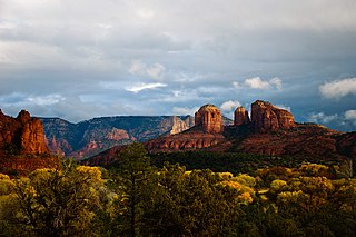
Red Rock State Park is a state park of Arizona, United States, featuring a red sandstone canyon outside the city of Sedona. The main mission of this day-use park is the preservation of the riparian habitat along Oak Creek. Red Rock State Park serves as an environmental education facility for the public and for school or private groups, and provides limited passive recreational opportunities.

The raid on Bear Valley was an armed conflict that occurred in 1886 during Geronimo's War. In late April, a band of Chiricahua Apaches attacked settlements in Santa Cruz County, Arizona over the course of two days. The Apaches raided four cattle ranches in or around Bear Valley, leaving four settlers dead, including a woman and her baby. They also captured a young girl, who was found dead several days after the event, and stole or destroyed a large amount of private property. When the United States Army learned of the attack, an expedition was launched to pursue the hostiles. In May, two small skirmishes were fought just across the international border in Sonora, Mexico but both times the Apaches were able to escape capture.
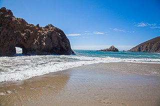
Pfeiffer Beach is located in the Big Sur region of California. It is one of the most popular beaches on the Central Coast and is well known for Keyhole Rock, a popular photography subject. On a limited number of days in December and January each year, photographers crowd the beach to obtain pictures of the setting sun visible through the arch. Due to the steep terrain prevalent along the Big Sur coast, it is one of the few ocean access points within Big Sur