Winnebago County, Wisconsin

Last updated

Winnebago County
WinnebagoCountyWisconsinCourthouse.jpg
Map of Wisconsin highlighting Winnebago County.svg
Location within the U.S. state of Wisconsin
Wisconsin in United States.svg
Wisconsin's location within the U.S.
Coordinates: 44°04′N88°38′W / 44.06°N 88.64°W / 44.06; -88.64
CountryFlag of the United States.svg United States
StateFlag of Wisconsin.svg  Wisconsin
Founded1848
Named for Winnebago people
Seat Oshkosh
Largest cityOshkosh
Area
  Total579 sq mi (1,500 km2)
  Land434 sq mi (1,120 km2)
  Water144 sq mi (370 km2)  25%
Population
 (2020) [1]
  Total171,730
  Density395.1/sq mi (152.5/km2)
Time zone UTC−6 (Central)
  Summer (DST) UTC−5 (CDT)
Congressional districts 6th, 8th
Website www.co.winnebago.wi.us

Winnebago County is a county in the U.S. state of Wisconsin. As of the 2020 census, the population was 171,730. Its county seat is Oshkosh. [2] It was named for the historic Winnebago people, a federally recognized Native American tribe now known as the Ho-Chunk Nation. Chief Oshkosh was a Menominee leader in the area. Winnebago County comprises the Oshkosh-Neenah, WI Metropolitan Statistical Area, which is included in the Appleton-Oshkosh-Neenah, WI Combined Statistical Area.

Contents

History

The region was occupied by several Native American tribes in the period of European encounter, including the Sauk, Fox, Menominee, and Ojibwa (known as Chippewa in the US). French traders from what is now Canada had early interaction with them, as did French Jesuit missionaries, who sought to convert them to Catholicism. European and American settlement encroached on their traditional territories, and the United States negotiated treaties in the mid-19th century to keep pushing the Indians to the west.

Winnebago County was created in 1840 by European Americans and organized in 1848. [3] The name Winnebago is of Algonquin origin, with variations used by the Fox and Potowatomi to refer to the Fox River below Lake Winnebago, which sometimes got muddy and full of fish. [4] It means 'people dwelling by the fetid or ill-smelling water', which may also refer to a sulfur spring. [5] The county seat, Oshkosh, was incorporated as a city in 1853, when it already had a population of nearly 2,800. [6]

Chief Oshkosh was the namesake for the county seat. A leader of the Menominee in the region, he was successful in gaining authorization from the federal government for 2500 of his people to remain in Wisconsin, at a time when the government was pushing for their removal west of the Mississippi River.

Geography

According to the U.S. Census Bureau, the county has a total area of 579 square miles (1,500 km2), of which 434 square miles (1,120 km2) is land and 144 square miles (370 km2) (25%) is water. [7]

Adjacent counties

Major highways

Railroads

Buses

Airports

Wittman Regional Airport (KOSH) serves the county and surrounding communities.

Brennand Airport (79C) in the Town of Clayton is a major recreational aircraft hub year-round.

Commercial airline service for Winnebago County is provided by Appleton International Airport in the neighboring Outagamie County.

Demographics

Historical population
CensusPop.Note
1840 135
1850 10,1677,431.1%
1860 23,770133.8%
1870 37,27956.8%
1880 42,74014.6%
1890 50,09717.2%
1900 58,22516.2%
1910 62,1166.7%
1920 63,8972.9%
1930 76,62219.9%
1940 80,5075.1%
1950 91,10313.2%
1960 107,92818.5%
1970 129,93120.4%
1980 131,7031.4%
1990 140,3206.5%
2000 156,76311.7%
2010 166,9946.5%
2020 171,7302.8%
U.S. Decennial Census [8]
1790–1960 [9] 1900–1990 [10]
1990–2000 [11] 2010–2020 [12]

2020 census

As of the census of 2020, [1] the population was 171,730. The population density was 395.1 people per square mile (152.5 people/km2). There were 76,046 housing units at an average density of 174.9 units per square mile (67.5 units/km2). The racial makeup of the county was 86.2% White, 3.3% Asian, 3.0% Black or African American, 0.7% Native American, 1.8% from other races, and 5.1% from two or more races. Ethnically, the population was 4.8% Hispanic or Latino of any race.

2000 Census Age Pyramid for Winnebago County USA Winnebago County, Wisconsin age pyramid.svg
2000 Census Age Pyramid for Winnebago County

2000 census

As of the census [13] of 2000, there were 156,763 people, 61,157 households, and 39,568 families residing in the county. The population density was 357 people per square mile (138 people/km2). There were 64,721 housing units at an average density of 148 units per square mile (57 units/km2). The racial makeup of the county was 94.92% White, 1.12% Black or African American, 0.46% Native American, 1.84% Asian, 0.02% Pacific Islander, 0.72% from other races, and 0.92% from two or more races. 1.96% of the population were Hispanic or Latino of any race. 52.4% were of German, 6.2% Irish and 5.7% Polish ancestry. 94.6% spoke English, 2.5% Spanish and 1.0% Hmong as their first language.

There were 61,157 households, out of which 31.00% had children under the age of 18 living with them, 53.00% were married couples living together, 8.30% had a female householder with no husband present, and 35.30% were non-families. 27.60% of all households were made up of individuals, and 9.90% had someone living alone who was 65 years of age or older. The average household size was 2.43 and the average family size was 2.99.

By age, 23.80% of the population was under 18, 11.80% from 18 to 24, 30.40% from 25 to 44, 21.50% from 45 to 64, and 12.50% were 65 or older. The median age was 35 years. For every 100 females there were 99.40 males. For every 100 females age 18 and over, there were 97.80 males.

In 2017, there were 1,833 births, giving a general fertility rate of 56.5 births per 1000 women aged 15–44, the 15th lowest rate out of all 72 Wisconsin counties. [14] Additionally, there were 123 reported induced abortions performed on women of Winnebago County residence in 2017. [15]

Government

Winnebago County is governed by the 36-member Winnebago County Board of Supervisors. Supervisors are elected to the board in a nonpartisan election held the first Tuesday of April in even numbered years and serve two-year terms. The board has several committees. It meets on the third Tuesday of each month at the Winnebago County Courthouse in Oshkosh.

Politics

Winnebago County has become a swing county in recent decades. It has voted for the winning presidential candidate in every election since 1980, except in 1992 when it supported George Bush, and in 2020, when it supported Donald Trump.

United States presidential election results for Winnebago County, Wisconsin [16] [17]
Year Republican Democratic Third party
No.%No.%No.%
2020 47,79650.83%44,06046.86%2,1762.31%
2016 43,44549.86%37,04742.52%6,6437.62%
2012 42,12247.24%45,44950.97%1,6021.80%
2008 37,94643.28%48,16754.94%1,5641.78%
2004 46,54252.53%40,94346.21%1,1111.25%
2000 38,33050.38%33,98344.67%3,7674.95%
1996 27,88042.73%29,56445.31%7,80311.96%
1992 33,70943.56%27,23435.19%16,44321.25%
1988 35,08554.82%28,50844.54%4100.64%
1984 39,01462.74%22,79136.65%3780.61%
1980 34,28653.28%24,20337.61%5,8649.11%
1976 32,14955.35%24,48542.16%1,4482.49%
1972 29,48857.28%20,45039.72%1,5443.00%
1968 25,36153.84%18,60539.50%3,1386.66%
1964 21,08447.03%23,63652.72%1150.26%
1960 28,59861.72%17,65638.11%800.17%
1956 28,75971.44%11,11527.61%3800.94%
1952 28,17268.17%13,01631.49%1400.34%
1948 17,16555.18%13,11642.16%8292.66%
1944 19,31059.56%12,84139.61%2690.83%
1940 18,69754.14%15,57045.08%2680.78%
1936 11,67936.93%18,52258.57%1,4204.49%
1932 11,50541.31%15,59155.98%7562.71%
1928 16,19161.10%9,99537.72%3151.19%
1924 11,23948.70%1,8017.80%10,03843.50%
1920 12,03569.53%3,39719.63%1,87610.84%
1916 5,92350.49%5,24244.69%5664.82%
1912 1,92217.01%4,63141.00%4,74341.99%
1908 6,79752.24%5,51142.36%7035.40%
1904 7,72062.63%4,00632.50%6004.87%
1900 7,46755.67%5,60541.78%3422.55%
1896 7,89859.23%5,08938.17%3472.60%
1892 5,35445.06%5,89349.60%6355.34%

Communities

Cities

Villages

Towns

Census-designated places

Unincorporated communities

Ghost towns/neighborhoods

Notable people

See also

Related Research Articles

<span class="mw-page-title-main">Shawano County, Wisconsin</span> County in Wisconsin, United States

Shawano County is a county located in the U.S. state of Wisconsin. As of the 2020 census, the population was 40,881. Its county seat is Shawano.

<span class="mw-page-title-main">Outagamie County, Wisconsin</span> County in Wisconsin

Outagamie County is a county in the Fox Cities region of the U.S. state of Wisconsin, located in the northeast of the state. As of the 2020 Census, the population was 190,705. Its county seat is Appleton.

<span class="mw-page-title-main">Fond du Lac County, Wisconsin</span> County in Wisconsin, United States

Fond du Lac County is a county in the U.S. state of Wisconsin. As of the 2020 census, the population was 104,154. Its county seat is Fond du Lac. The county was created in the Wisconsin Territory in 1836 and later organized in 1844. Fond du Lac is French for "bottom of the lake", given so because of the county's location at the southern shore of Lake Winnebago. Fond du Lac County comprises the Fond du Lac, Wisconsin Metropolitan Statistical Area. The Holyland region is in northeastern Fond du Lac County.

<span class="mw-page-title-main">Calumet County, Wisconsin</span> County in Wisconsin, United States

Calumet County is a county located in the U.S. state of Wisconsin. As of the 2020 census, the population was 52,442. The county seat is Chilton. The county was created in 1836 and organized in 1850.

<span class="mw-page-title-main">Brown County, Wisconsin</span> County in Wisconsin, United States

Brown County is a county in the U.S. state of Wisconsin. As of the 2020 census, the population was 268,740, making it the fourth-most populous county in Wisconsin. The county seat is Green Bay. Brown County is part of the Green Bay, WI Metropolitan Statistical Area.

<span class="mw-page-title-main">Grand Chute, Wisconsin</span> Town in Wisconsin, United States

Grand Chute is a town in Outagamie County, Wisconsin, United States. The population was 23,831 at the 2020 census. The unincorporated community of Apple Creek is partially located in the town. It was the birthplace of U.S. Senator Joseph McCarthy.

<span class="mw-page-title-main">Hortonville, Wisconsin</span> Village in Wisconsin, United States

Hortonville is a village in Outagamie County, Wisconsin, United States. The population was 2,711 at the 2010 census.

<span class="mw-page-title-main">Shiocton, Wisconsin</span> Village in Wisconsin, United States

Shiocton is a village in Outagamie County, Wisconsin, United States. The population was 921 at the 2010 census. It is wholly surrounded by the Town of Bovina.

<span class="mw-page-title-main">Appleton, Wisconsin</span> City in Wisconsin, United States

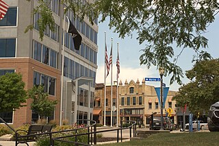
Appleton is a city in and the county seat of Outagamie County in the U.S. state of Wisconsin. A small portion of the city also extends into Calumet and Winnebago counties. One of the Fox Cities, it is situated on the Fox River, 30 miles (48 km) southwest of Green Bay and 100 miles (160 km) north of Milwaukee. As of the 2020 census, it had a population of 75,644, making it the sixth-most populous city in Wisconsin. Appleton is a part of the Fox Cities metropolitan area, the third-largest metro area in the state.

<span class="mw-page-title-main">Menasha, Wisconsin</span> City in Wisconsin, United States

Menasha is a city in Calumet and Winnebago counties in the U.S. state of Wisconsin. The population was 18,268 at the 2020 census. Of this, 15,144 were in Winnebago County, and 2,209 were in Calumet County. The city is located mostly in Winnebago County; only a small portion is in the Town of Harrison in Calumet County. Doty Island is located partially in Menasha. The city's name comes from the Winnebago word meaning "thorn" or "island". In the Menominee language, it is known as Menāēhsaeh, meaning "little island".

<span class="mw-page-title-main">Kaukauna, Wisconsin</span> City in Wisconsin, United States

Kaukauna is a city in Outagamie and Calumet counties, Wisconsin, United States. It is situated on the Fox River, approximately 100 miles (160 km) north of Milwaukee. The population was 17,089 at the 2020 census. It is a part of the Appleton, Wisconsin Metropolitan Statistical Area.

<span class="mw-page-title-main">Neenah, Wisconsin</span> Human settlement in Wisconsin, USA, since 1835

Neenah is a city in Winnebago County, Wisconsin, in the north central United States. It is situated on the banks of Lake Winnebago, Little Lake Butte des Morts, and the Fox River, approximately forty miles (64 km) southwest of Green Bay. Neenah's population was 27,319 at the 2020 census.

<span class="mw-page-title-main">Oshkosh, Wisconsin</span> City in Wisconsin, United States

Oshkosh is a city in and the county seat of Winnebago County, Wisconsin, United States. The city had a population of 66,816 in 2020, making it the ninth-most populous city in Wisconsin. It is also adjacent to the much less populous Town of Oshkosh in the north.

Winneconne is a town in Winnebago County, Wisconsin, United States. The population was 2,350 at the 2010 census. The Village of Winneconne is located within the town, on both sides of the Wolf River. The unincorporated community of Butte des Morts, named for a French and Native American trading war, is also located in the town. The town's water resources of rivers and lakes makes it a center of hunting and fishing, including winter ice fishing.

<span class="mw-page-title-main">Winneconne, Wisconsin</span> Village in Wisconsin, United States

Winneconne is a village in Winnebago County, Wisconsin. The population was 2,383 at the time of the 2010 census. The village is located within the Town of Winneconne. Developed along the Wolf River, the city is in the middle of the Wolf Chain of lakes, including Poygan, Winneconne, and Butte des Morts. It is host to numerous bass fishing tournaments.

<span class="mw-page-title-main">Lake Winnebago</span> Lake in Wisconsin

Lake Winnebago is a shallow freshwater lake in the north central United States, located in east central Wisconsin. At 137,700 acres, it is the largest lake entirely within the state, covering an area of about 30 miles by 10 miles with 88 miles of shoreline, an average depth of 15.5 feet, and a maximum depth of 21 feet. It has many shallow reefs along the west shore and a drop-off type shoreline on the east. There are several islands along the west shore.

<span class="mw-page-title-main">Wolf River (Fox River tributary)</span> Principal tributary of Fox River of Green Bay in eastern Wisconsin

The Wolf River is a 225 mi (362 km) long tributary of the Fox River in northeastern Wisconsin in the Great Lakes region of the United States. The river is one of the two National Scenic Rivers in Wisconsin, along with the St. Croix River. The scenic portion is 24 miles (39 km) long. The river and its parent the Fox River and associated lakes are known for their sturgeon which spawn every spring upstream on the lower river until blocked by the Shawano Dam. The river flows through mostly undeveloped forestland southerly from central Forest County in the north to Lake Poygan in the south. The lake is part of the Winnebago Pool of lakes fed by both the Fox and Wolf Rivers. The Fox-Wolf basin is usually considered to be a single unified basin and the rivers themselves may be referred to as the Fox-Wolf River system.

<span class="mw-page-title-main">Fox Cities</span> Combined Statistical Area in Wisconsin, United States

The Fox Cities of Northeastern Wisconsin are the cities, towns and villages along the Fox River as it flows from Lake Winnebago northward into Green Bay.

Wisconsin's 6th congressional district is a congressional district of the United States House of Representatives in eastern Wisconsin. It is based in the rural, suburban and exurban communities between Madison, Milwaukee, and Green Bay. It also includes the village of River Hills in far northern Milwaukee County. The district is currently represented by Glenn Grothman (R-Glenbeaulah) who took office in January 2015.

<span class="mw-page-title-main">Delhi, Wisconsin</span> Ghost Town in Wisconsin, United States

Delhi, Wisconsin is a ghost town in the town of Rushford, Winnebago County, Wisconsin, United States. It is located on County Highway E between Omro and Eureka at the junction of the Fox River and Waukau Creek. Delhi was also known as La Borde's Landing. 1890 census records identify Delhi as Island Park. Delhi had an established post office between 1850-1893.

References

  1. 1 2 "2020 Decennial Census: Winnebago County, Wisconsin". data.census.gov. U.S. Census Bureau. Retrieved July 3, 2022.
  2. "Find a County". National Association of Counties. Retrieved June 7, 2011.
  3. "Wisconsin: Individual County Chronologies". Wisconsin Atlas of Historical County Boundaries. The Newberry Library. 2007. Archived from the original on April 14, 2017. Retrieved August 15, 2015.
  4. "Winnebago", Dictionary.com
  5. "Winnebago Took Its Name from an Indian Tribe". The Post-Crescent. December 28, 1963. p. 14. Retrieved August 25, 2014 via Newspapers.com. Open Access logo PLoS transparent.svg
  6. City of Oshkosh. About Us.
  7. "2010 Census Gazetteer Files". United States Census Bureau. August 22, 2012. Retrieved August 9, 2015.
  8. "U.S. Decennial Census". United States Census Bureau. Retrieved August 9, 2015.
  9. "Historical Census Browser". University of Virginia Library. Retrieved August 9, 2015.
  10. Forstall, Richard L., ed. (March 27, 1995). "Population of Counties by Decennial Census: 1900 to 1990". United States Census Bureau. Retrieved August 9, 2015.
  11. "Census 2000 PHC-T-4. Ranking Tables for Counties: 1990 and 2000" (PDF). United States Census Bureau. April 2, 2001. Archived (PDF) from the original on October 9, 2022. Retrieved August 9, 2015.
  12. "State & County QuickFacts". United States Census Bureau. Archived from the original on February 24, 2016. Retrieved January 24, 2014.
  13. "U.S. Census website". United States Census Bureau . Retrieved May 14, 2011.
  14. "Annual Wisconsin Birth and Infant Mortality Report, 2017 P-01161-19 (June 2019): Detailed Tables". Archived from the original on June 19, 2019. Retrieved June 19, 2019.
  15. Reported Induced Abortions in Wisconsin, Office of Health Informatics, Division of Public Health, Wisconsin Department of Health Services. Section: Trend Information, 2013-2017, Table 18, pages 17-18
  16. Leip, David. "Dave Leip's Atlas of U.S. Presidential Elections". uselectionatlas.org. Retrieved November 11, 2020.
  17. The leading "other" candidate, Progressive Theodore Roosevelt, received 4,098 votes, while Socialist candidate Eugene Debs received 478 votes, Prohibition candidate Eugene Chafin received 146 votes, and Independent candidate Arthur Reimer received 21 votes.
  18. "Madison, Martin". Political Graveyard. Retrieved December 21, 2013.

Further reading

44°04′N88°38′W / 44.06°N 88.64°W / 44.06; -88.64