Related Research Articles

Georgetown County is a county located in the U.S. state of South Carolina. As of the 2020 census, the population was 63,404. Its county seat is Georgetown. The county was founded in 1769. It is named for George III of the United Kingdom.
The Pee Dee River, also known as the Great Pee Dee River, is a river in the Carolinas of the United States. It originates in the Appalachian Mountains in North Carolina, where its upper course, above the mouth of the Uwharrie River, is known as the Yadkin River. The river empties into Winyah Bay, and then into the Atlantic Ocean near Georgetown.
The Santee River is a river in South Carolina in the United States, and is 143 miles (230 km) long. The Santee and its tributaries provide the principal drainage for the coastal areas of southeastern South Carolina and navigation for the central coastal plain of South Carolina, emptying into the Atlantic Ocean about halfway between Myrtle Beach and Charleston near the community of McClellanville. The farthest headwaters lie 440 miles (708 km) away on the Catawba River in North Carolina. Besides the Catawba, other principal rivers of the Santee watershed include the Congaree, Broad, Linville, Saluda and the Wateree. The watershed drains a large portion of the Piedmont regions of South and North Carolina. The Santee River is the second largest river on the eastern coast of the United States, second only to the Susquehanna River in drainage area and flow. Much of the upper river is impounded by the expansive, horn-shaped Lake Marion reservoir, formed by the 8-mile (13 km)-long Santee Dam. The dam was built during the Great Depression of the 1930s as a Works Progress Administration (WPA) project to provide a major source of hydroelectric power for the state of South Carolina.

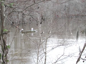
The Waccamaw River is a river, approximately 140 miles (225 km) long, in southeastern North Carolina and eastern South Carolina in the United States. It drains an area of approximately 1,110 square miles (2886 km²) in the coastal plain along the eastern border between the two states into the Atlantic Ocean. Along its upper course, it is a slow-moving, blackwater river surrounded by vast wetlands, passable only by shallow-draft watercraft such as canoe. Along its lower course, it is lined by sandy banks and old plantation houses, providing an important navigation channel with a unique geography, flowing roughly parallel to the coast.
The Waccamaw people were an Indigenous people of the Southeastern Woodlands, who lived in villages along the Waccamaw and Pee Dee rivers in North and South Carolina in the 18th century.
The Yamasee War was a conflict fought in South Carolina from 1715 to 1717 between British settlers from the Province of Carolina and the Yamasee, who were supported by a number of allied Native American peoples, including the Muscogee, Cherokee, Catawba, Apalachee, Apalachicola, Yuchi, Savannah River Shawnee, Congaree, Waxhaw, Pee Dee, Cape Fear, Cheraw, and others. Some of the Native American groups played a minor role, while others launched attacks throughout South Carolina in an attempt to destroy the colony.
The Cape Fear Indians were a small, coastal tribe of Native Americans who lived on the Cape Fear River in North Carolina.

The Pee Dee people, also Pedee and Peedee, are American Indians of the Southeast United States. Historically, their population has been concentrated in the Piedmont of present-day South Carolina. In the 17th and 18th centuries, English colonists named the Pee Dee River and the Pee Dee region of South Carolina for the tribe.
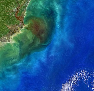
Winyah Bay is a coastal estuary that is the confluence of the Waccamaw River, the Pee Dee River, the Black River, and the Sampit River in Georgetown County, in eastern South Carolina. Its name comes from the Winyaw, who inhabited the region during the eighteenth century. The historic port city of Georgetown is located on the bay, and the bay generally serves as the terminating point for the Grand Strand.

The Wateree River, about 75 mi (120 km) long, is a tributary of the Santee River in central South Carolina in the United States, which flows to the Atlantic Ocean. It was named for the Wateree Native Americans, a tribe who had migrated to this area from western North Carolina. They lived here until the early 18th century, when they were set upon and displaced by mostly English settlers during the Yamasee War. Survivors merged with the larger Catawba people, becoming extinct as a tribe.

The Cheraw people, also known as the Saraw or Saura, were a Siouan-speaking tribe of Indigenous people of the Southeastern Woodlands, in the Piedmont area of North Carolina near the Sauratown Mountains, east of Pilot Mountain and north of the Yadkin River. They lived in villages near the Catawba River. Their first European and African contact was with the Hernando De Soto Expedition in 1540. The early explorer John Lawson included them in the larger eastern-Siouan confederacy, which he called "the Esaw Nation."
The Wateree were a Native American tribe in the interior of the present-day Carolinas. They probably belonged to the Siouan-Catawba language family. First encountered by the Spanish in 1567 in Western North Carolina, they migrated to the southeast and what developed as South Carolina by 1700, where English colonists noted them.
The Congaree were a historic group of Native Americans who once lived within what is now central South Carolina, along the Congaree River. They spoke a language distinct from and not mutually intelligible with other local Siouan languages. The language today is generally considered unclassified, though, some linguists believe that the language was related to Catawba. The tribe joined the Catawba Nation in company of the Wateree several years after temporarily migrating to the Waccamaw River in 1732. During the middle of the eighteenth century, Congaree was considered one of the languages spoken within the Catawba Nation.

The Cusabo or Cosabo were a group of American Indian tribes who lived along the coast of the Atlantic Ocean in what is now South Carolina, approximately between present-day Charleston and south to the Savannah River, at the time of European colonization. English colonists often referred to them as one of the Settlement Indians of South Carolina, tribes who "settled" among the colonists.
The Waxhaw people were a tribe native to what are now the counties of Lancaster, in South Carolina; and Union and Mecklenburg in North Carolina, around the area of present-day Charlotte. The Waxhaw were related to other nearby Southeastern peoples, such as the Catawba people and the Sugeree. It is speculated that they were culturally influenced by the Mississippian culture.
King Yanabe Yalangway was the eractasswa (chief) of the Catawba Indian Nation, sometime around the 1740s. Not much is known about him other than the fact that he preceded King Hagler as chief. His training was evidently under "king" Whitmannetaughehee's leadership.
Francisco de Chicora was the baptismal name given to a Native American kidnapped in 1521, along with 70 others, from near Winyah Bay by Spanish explorer Francisco Gordillo and slave trader Pedro de Quexos, based in Santo Domingo and the first Europeans to reach the area. From analysis of the account by Peter Martyr, court chronicler, the ethnographer John R. Swanton believed that Chicora was from a Catawban group.
The Sewee or "Islanders" were a Native American tribe that lived in present-day South Carolina in North America.
References
- South, Stanley (1972). "The Unabridged Version of Tribes of the Carolina Lowland: Pedee - Sewee - Winyaw - Waccamaw - Cape Fear - Congaree - Wateree - Santee". Research Manuscript Series. Columbia: The South Carolina Institute of Archeology and Anthropology--University of South Carolina: 31–32.
- Swanton, John Reed (1952). The Indian Tribes of North America. Genealogical Publishing Com. pp. 102–03. ISBN 9780806317304.