
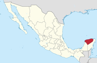
Xculoc is a village in Campeche, Mexico. [1] This settlement of Maya people is located 20 kilometres south of Uxmal and the same distance west of Sayil. [2]
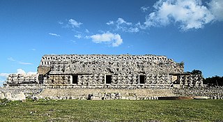
Ancient Mayan Classic Period Puuc style Mayan building ruins are located in Xculoc.
Xculoc is a village in Campeche, Mexico. [1] This settlement of Maya people is located 20 kilometres south of Uxmal and the same distance west of Sayil. [2]
Ancient Mayan Classic Period Puuc style Mayan building ruins are located in Xculoc.
Yucatán, officially the Free and Sovereign State of Yucatán, is one of the 31 states which comprise the federal entities of Mexico. It comprises 106 separate municipalities, and its capital city is Mérida.

Orange Walk District is a district in the northwest of the nation of Belize, with its district capital in Orange Walk Town.

Becan is an archaeological site of the Maya civilization in pre-Columbian Mesoamerica. Becan is located near the center of the Yucatán Peninsula, in the present-day Mexican state of Campeche, about 150 km (93.2 mi) north of Tikal. The Maya sites of Balamku, Calakmul, Chicanna and Xpuhil are nearby. The name Becan was bestowed on the site by archaeologists who rediscovered the site, meaning "ravine or canyon formed by water" in Yukatek Maya, after the site's most prominent and unusual feature, its surrounding ditch.

Uxmal is an ancient Maya city of the classical period located in present-day Mexico. It is considered one of the most important archaeological sites of Maya culture, along with Palenque, Chichen Itza and Calakmul in Mexico, Caracol and Xunantunich in Belize, and Tikal in Guatemala. It is located in the Puuc region of the eastern Yucatán Peninsula, and is considered one of the Maya cities most representative of the region's dominant architectural style. It has been designated a UNESCO World Heritage Site in recognition of its significance.

Champotón is a small city in Champotón Municipality in the Mexican state of Campeche, located at 19°21′N90°43′W, about 60 km south of the city of Campeche where the small Champotón river meets the coast of the Gulf of Mexico. At the 2010 census it had a population of 30,881.

Tekax, sometimes spelled Tecax, is a small city in the Mexican state of Yucatán, located at 20°12′07″N89°17′17″W in the southernmost part of the state. Tekax means "Place of the Forests" in the Yucatec Maya language. Tekax was briefly declared the capital of Yucatán in 1845. Tekax is also the name of the surrounding municipality of which the city of Tekax serves as municipal seat of government.

The Maya peoples are an ethnolinguistic group of indigenous peoples of Mesoamerica. The ancient Maya civilization was formed by members of this group, and today's Maya are generally descended from people who lived within that historical civilization. Today they inhabit southern Mexico, Guatemala, Belize, El Salvador and Honduras. "Maya" is a modern collective term for the peoples of the region, however, the term was not historically used by the indigenous populations themselves. There was no common sense of identity or political unity among the distinct populations, societies and ethnic groups because they each had their own particular traditions, cultures and historical identity.
Kabah is a Maya archaeological site in the Puuc region of western Yucatan, south of Mérida.

Campeche, officially the Free and Sovereign State of Campeche, is one of the 31 states which make up the 32 Federal Entities of Mexico. Located in southeast Mexico, it is bordered by the states of Tabasco to the southwest, Yucatán to the northeast, and Quintana Roo to the east; to the southeast by the Orange Walk district of Belize, and by the Petén department of Guatemala to the south. It has a coastline to the west with the Gulf of Mexico. The state capital, also called Campeche, was declared a World Heritage Site in 1997. The formation of the state began with the city, which was founded in 1540 as the Spanish began the conquest of the Yucatán Peninsula. The city was a rich and important port during the colonial period, but it declined after Mexico's independence. Campeche was part of the province of Yucatán but split off in the mid-19th century, mostly due to political friction with the city of Mérida. Much of the state's recent economic revival is due to the discovery of petroleum offshore in the 1970s, which has made the coastal cities of Campeche and Ciudad del Carmen important economic centers. The state has important Mayan and colonial sites; however, these are not as well-known or visited as others in the Yucatán.

Jaina Island is a pre-Columbian Maya archaeological site in the present-day Mexican state of Campeche. A small limestone island on the Yucatán Peninsula's Gulf coast with only a tidal inlet separating it from the mainland, Jaina served as an elite Maya burial site, and is notable for the high number of fine ceramic figurines excavated there.
Xcaret is a Maya civilization archaeological site located on the Caribbean coastline of the Yucatán Peninsula, in the state of Quintana Roo in Mexico. The site was occupied by the pre-Columbian Maya and functioned as a port for navigation and an important Maya trading center. Some of the site's original structures are contained within a modern-day tourism development, the privately owned Xcaret Park.
Acanceh is a town and ancient Maya archaeological site located in Mexico's Yucatán State, 21 kilometers from Mérida, the capital of Yucatán. It is the seat of Acanceh Municipality. The modern town of Acanceh, is partially atop the pre-Columbian site, and occupation seems to have been continuous. Acanceh means "groan of the deer" in the Yucatec Maya language.
The Petén Basin is a geographical subregion of Mesoamerica, primarily located in northern Guatemala within the Department of El Petén, and into Campeche state in southeastern Mexico.
Maxcanú is a large town in the western part of the Mexican state of Yucatán; it also functions as the seat for the Maxcanú Municipality. It is located on Federal Highway 180, approximately 62 km (38.5 mi) south of Mérida.

Chicanná was a Maya town that was built during the Classic period. The site was named after its most famous building, Structure II, which means "House of the Serpent Mouth" in Mayan. In the Mayan language chi means "mouth", can means "serpent" and na means "house". The site is located two kilometers west of Becán in the Mexican state of Campeche on the Yucatán peninsula. It is one of 45 other ruin sites located within that area.
Calkiní is a city in the Mexican state of Campeche. It is situated at the northern tip of the state, on the central western coast the Yucatán Peninsula. It serves as the municipal seat for the surrounding municipality of the same name. As of 2010, the city of Calkiní had a population of 14,934.

Chactún is the name of an archaeological site of the Mesoamerican Maya civilization in the state of Campeche, Mexico, in the northern part of the Calakmul Biosphere Reserve. The site of approximately 54 acres (22 ha) is located in the lowlands of the Yucatán Peninsula, between the regions of Rio Bec and Chenes. There are some significant differences that have yet to be explained completely, which distinguish it from some of the other nearby sites.

Tekantó Municipality is a small (47.25 km²) municipality in the Mexican state of Yucatán. The municipality was formed in 1900 and its municipal seat is the homonymous locality of Tekantó, at the end of highway 80, 54 km east of Merida.
Hormiguero was a Mayan city which was at its peak in the Late Classic Period (650–850). It is located 22 kilometers south of Xpuhil in the Mexican state of Campeche. Only a few of its 84 known structures have been excavated. Structure II is the most completely excavated building at the site and one of the most wildly theatrical of all Rio Bec buildings. It is a rectangular platform, with two soaring, false-staircase towers either side of a colossal Chenes-style monster-portal. Inside there are several large chambers. Nearby is the Central Group, a complex of large temples, most of which are not excavated. Of those that are, Structure V is the most impressive. It is a towering pyramid with a well-preserved Chenes-style temple at the top.
Uxul is an ancient Maya settlement in the Campeche region of Mexico. It was at the pinnacle of its existence in the classical period, and was located in a densely populated area between the larger Maya cities of El Mirador to the south and Calakmul to the northeast. Uxul is a Mayan term meaning “at the end”, signifying its remoteness, however this was not the original name for the settlement, but a name coined by the two men who rediscovered it in 1934, Karl Ruppert and John H. Denison.
Campeche (capital) | ||
| Municipalities (municipal seats) |  | |