Y Gaer (cultural hub)

Last updated

Y Gaer
Y Gaer cultural hub, Brecon.jpg
Y Gaer
LocationGlamorgan Street, Brecon
Coordinates 51°56′46″N3°23′22″W / 51.9462°N 3.3895°W / 51.9462; -3.3895
Built1843
Architect Thomas Henry Wyatt and David Brandon
Architectural style(s) Neoclassical style
Website www.ygaerpowys.org.uk
Listed Building – Grade II*
Official nameBrecknock Museum
Designated16 January 1952
Reference no.7116
Powys UK location map.svg
Red pog.svg
Shown in Powys

Y Gaer (English: The Fortress) is a municipal structure in Glamorgan Street, Brecon, Powys, Wales. The complex, which includes a museum, an art gallery and a library and incorporates a structure which was once the shire hall for Brecknockshire, is a Grade II* listed building. [1]

Contents

History

The original shire hall building was commissioned by the justices as accommodation for the quarter sessions and for the regular assizes. [2] [3] It was designed by Thomas Henry Wyatt and David Brandon in the neoclassical style, built in ashlar stone and was completed in 1843. [1] The design involved a symmetrical main frontage with five bays facing the corner of Bulwark and Danygaer Road; the central section of three bays featured a full height tetrastyle portico with Doric order columns supporting an entablature inscribed with the words "Victoria Regina MDCCCXLII", as well as a frieze with triglyphs and a modillioned pediment. [1] The outer bays contained single-storey blocks with three-light windows. [1] Internally, the principal room was the courtroom. [1]

Following the implementation of the Local Government Act 1888, which established county councils in every county, it became necessary to establish a meeting place for the newly formed Brecknockshire County Council and facilities in the shire hall were identified for this purpose. [4] The shire hall continued to host court hearings until 1971 [3] and to host meetings of the county council until it was abolished in 1974. [5] The county council's main offices were at Watton Mount, a large house directly opposite the shire hall, until 1962 when New County Hall was built immediately behind the shire hall. Following the local government reorganisation in 1974, the New County Hall became an area office for Powys County Council and also served as offices for the Brecon Beacons National Park Authority, but the old shire hall was left vacant. [6] [7] [8]

The Brecknock Museum, which had been established in an old chapel further to the west along Glamorgan Street in 1928, [9] [10] moved into the vacant shire hall in 1974. [11] Highlights of the collection included a tombstone of a young cavalryman called Candidus, found at Y Gaer, a local Roman fort. [12]

After funding had been secured from the Heritage Lottery Fund, a major programme of works to create a new cultural hub for the area was initiated in August 2016. The project involved demolition of the New County Hall and an adjoining Victorian police station and the construction of a modern building on the site, linked to the retained old shire hall. [8] The works, which were carried out by Kier Group at a cost of £14 million, [13] [14] [15] included the refurbishment of the shire hall, the creation of a new art gallery and the construction of a new library building for Brecon Library which relocated from Ship Street. The complex was named Y Gaer to recall the name of the local Roman fort. [16] The works were completed in December 2019. [17]

See also

Related Research Articles

<span class="mw-page-title-main">Brecon Beacons</span> Region and national park in south Wales

The Brecon Beacons, or Bannau Brycheiniog ( ), is a mountainous region and national park in Wales. The name 'Brecon Beacons' was originally applied only to the mountain range south of Brecon, Powys, which is now also known as the Central Beacons. The range includes South Wales' highest mountain, Pen y Fan, its twin summit Corn Du, and Craig Gwaun Taf, which are the three highest peaks in the range.

<span class="mw-page-title-main">Llansantffraed</span> Human settlement in Wales

Llansantffraed (Llansantffraed-juxta-Usk) is a parish in the community of Talybont-on-Usk in Powys, Wales, near Brecon. The benefice of Llansantffraed with Llanrhystud and Llanddeiniol falls within the Diocese of St Davids in the Church in Wales.

<span class="mw-page-title-main">Powys</span> County and preserved county in Wales

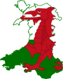
Powys is a county and preserved county in Wales. It borders Gwynedd, Denbighshire, and Wrexham to the north; the English ceremonial counties of Shropshire and Herefordshire to the east; Monmouthshire, Blaenau Gwent, Merthyr Tydfil, Caerphilly, Rhondda Cynon Taf, and Neath Port Talbot to the south; and Carmarthenshire and Ceredigion to the west. The largest settlement is Newtown, and the administrative centre is Llandrindod Wells.

<span class="mw-page-title-main">Brecon</span> Town in Powys, Mid Wales

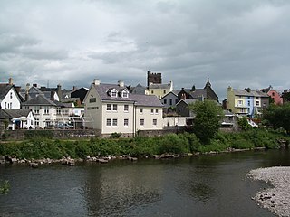
Brecon, archaically known as Brecknock, is a market town in Powys, mid Wales. In 1841, it had a population of 5,701. The population in 2001 was 7,901, increasing to 8,250 at the 2011 census. Historically it was the county town of Brecknockshire (Breconshire); although its role as such was eclipsed with the formation of the County of Powys, it remains an important local centre. Brecon is the third-largest town in Powys, after Newtown and Ystradgynlais. It lies north of the Brecon Beacons mountain range, but is just within the Brecon Beacons National Park.

<span class="mw-page-title-main">Brecknockshire</span> Historic county of Wales

Brecknockshire, also known as the County of Brecknock, Breconshire, or the County of Brecon is one of thirteen historic counties of Wales, and a former administrative county. Named after its county town of Brecon, the county is mountainous and primarily rural.

<span class="mw-page-title-main">Crickhowell</span> Town in Wales

Crickhowell is a town and community in southeastern Powys, Wales, near Abergavenny, and is in the historic county of Brecknockshire.

<span class="mw-page-title-main">Talgarth</span> Market town and community in Powys, Wales

Talgarth is a market town, community and electoral ward in southern Powys, Mid Wales, about 12 miles (19 km) north of Crickhowell, 19 miles (31 km) north-east of Brecon and 15 miles (24 km) south-east of Builth Wells. Notable buildings in the town include the 14th-century parish church and a defensive tower house. According to traditional accounts, Talgarth was the capital of the early medieval kingdom of Brycheiniog. It is in the historic county of Brecknockshire. In 2011, it had a population of 1,724.

<span class="mw-page-title-main">Pen y Fan</span> Welsh mountain peak of the Brecon Beacons, Powys

Pen y Fan is the highest peak in South Wales, situated in Brecon Beacons National Park. At 886 metres (2,907 ft) above sea-level, it is also the highest British peak south of Cadair Idris in Snowdonia. It is the highest point of the historic county of Brecknockshire. The twin summits of Pen y Fan and Corn Du at 873 metres (2,864 ft) were formerly referred to as Cadair Arthur or 'Arthur's Seat'.

<span class="mw-page-title-main">Trecastle</span> Village in Powys, Wales

Trecastle is a village in Powys, Wales, situated on the edge of the Brecon Beacons National Park (Welsh: Parc Cenedlaethol Bannau Brycheiniog) and in the community of Llywel. The village has a population of about 200.

<span class="mw-page-title-main">Bronllys</span> Human settlement in Wales

Bronllys is a village and community in Powys, Wales between the nearby towns Brecon and Talgarth. Bronllys is also the name of an electoral ward to Powys County Council. The community includes Llyswen.

<span class="mw-page-title-main">Borough of Brecknock</span> Former district of Powys, Wales

The Borough of Brecknock was one of the three local government districts of the county of Powys, Wales from 1974 until 1996. It covered the majority of the former administrative county of Brecknockshire. The borough was abolished in 1996, with Powys County Council taking over its functions.

<span class="mw-page-title-main">Powys County Council</span> Local government of Powys, Wales

Powys County Council is the local authority for Powys, one of the administrative areas of Wales. The County Hall is in Llandrindod Wells.

Glasbury, also known as Glasbury-on-Wye, is a village and community in Powys, Wales. The village lies at an important crossing point on the River Wye, connecting the historic counties of Brecknockshire and Radnorshire, and is located just outside the Brecon Beacons National Park, north of the Black Mountains. The village is split between the communities of Glasbury and Gwernyfed. The nearest town is Hay-on-Wye, some 4 miles (6 km) to the north east. The nearest city is Hereford in England, some 25 miles (40 km) to the east. Glasbury is a popular location for river fishing, canoeing and kayaking. The population of Glasbury community in Radnorshire was 994, in 1841 it was 838.

<span class="mw-page-title-main">Y Gaer</span>

Y Gaer is a Roman fort situated near modern-day Brecon in Mid Wales, United Kingdom. Y Gaer is located at grid reference SO00332966.

<span class="mw-page-title-main">Llangattock, Powys</span> Village and community in Powys, Wales

Llangattock is a village, community and electoral ward in the Brecon Beacons National Park in Powys, Wales. It lies in the Usk Valley just across the river from the town of Crickhowell. The Monmouthshire and Brecon Canal passes through the village en route between Brecon and Pontypool. It is in the historic county of Breconshire.

Pipton is a small settlement and former civil parish in Powys, Wales on the Afon Llynfi near its confluence with the River Wye. It was formerly in the county of Brecknockshire and is now part of the community of Bronllys. The nearest town is Hay-on-Wye some 5 miles (8.0 km) to the east.

<span class="mw-page-title-main">Defynnog</span> Village in Wales

Defynnog, also known as Devynock in some historical documents, is a small village in the community of Maescar in the historic county of Brecknockshire, Wales, now lying within the unitary authority area of Powys. It lies immediately south of Sennybridge and about ten miles west of Brecon within the Brecon Beacons National Park.

<span class="mw-page-title-main">Glyntawe</span> Human settlement in Wales

Glyntawe is a hamlet and parish on the upper reaches of the River Tawe in Powys, Wales, in the community of Tawe-Uchaf. It has always been sparsely populated. Today it attracts tourists for outdoor activities in the Brecon Beacons National Park and for caving.

<span class="mw-page-title-main">Crickhowell Market Hall</span> Municipal Building in Crickhowell, Wales

Crickhowell Market Hall, formerly Crickhowell Town Hall, is a municipal building in the High Street, Crickhowell, Powys, Wales. The structure, which accommodates market stalls on the ground floor and a café on the first floor, is a Grade II* listed building.

References

  1. 1 2 3 4 5 Cadw. "Brecknock Museum (7116)". National Historic Assets of Wales . Retrieved 7 October 2021.
  2. The Law Times Reports of Cases Decided in the House of Lords, The Privy Council and The Court of Appeal. Vol. 28. Butterworth. 19 July 1873. p. 698.
  3. 1 2 "Part of the reconstructed Brecon Assize court of 1880". Gathering the Jewels. Archived from the original on 1 October 2005. Retrieved 7 October 2021.
  4. "Brecknockshire County Council". South Wales Daily News. 8 February 1889. Retrieved 7 October 2021.
  5. "Brecknockshire County Council". Gwent Archives. Retrieved 7 October 2021.
  6. "Watton Mount". Coflein. Royal Commission on the Ancient and Historical Monuments of Wales. Retrieved 2 October 2022.
  7. "Listed building consent report 14/11209/LBC" (PDF). Brecon Beacons National Park Authority. p. 138. Retrieved 2 October 2022.
  8. 1 2 "Planning application 14/11208/FUL: Demolition of the former County Hall building and Grade II* listed former Police Station and the erection of a two storey Cultural Hub building with glass atrium linked to the existing Grade II* listed Brecknock Museum..." Brecon Beacons National Park Authority. Retrieved 2 October 2022.
  9. Cadw. "The Old Museum (6892)". National Historic Assets of Wales . Retrieved 7 October 2021.
  10. Foster, Janet; Sheppard, Julia (2014). British Archives: A Guide to Archive Resources in the UK. Palgrave. p. 68. ISBN   978-1349118144.
  11. "About the Museum & Art Gallery". Brecknock Museum & Art Gallery. Retrieved 7 October 2021.
  12. "The Maiden stone from Brecon Gaer (Roman fort), 1809". Gathering the Jewels. Retrieved 7 October 2021.
  13. "Kier Group cash call prompts Powys councillors' concern". BBC. 13 December 2018. Retrieved 7 October 2021.
  14. "Y Gaer: Brecon cultural scheme investigation to resume". BBC. 5 September 2020. Retrieved 7 October 2021.
  15. "Y Gaer project report highlights knowledge and experience". Powys County Times. 6 October 2021. Retrieved 7 October 2021.
  16. "The Maiden stone from Brecon Gaer (Roman fort), 1809". Gathering the Jewels. peoplescollectionwales.co.uk. Retrieved 7 October 2021.
  17. "Brecon museum and library complex Y Gaer to open in December". BBC. 17 October 2019. Retrieved 7 October 2021.