Related Research Articles
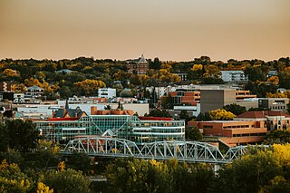
Medicine Hat is a city in southeast Alberta, Canada. It is located along the South Saskatchewan River. It is approximately 169 km (105 mi) east of Lethbridge and 295 km (183 mi) southeast of Calgary. This city and the adjacent Town of Redcliff to the northwest are within Cypress County. Medicine Hat was the sixth-largest city in Alberta in 2016 with a population of 63,230. It is also the sunniest place in Canada according to Environment and Climate Change Canada, averaging 2,544 hours of sunshine a year.

Lloydminster is a Canadian city which has the unusual geographic distinction of straddling the provincial border between Alberta and Saskatchewan. The city is incorporated by both provinces as a single city with a single municipal administration.
Fort Saskatchewan is a mid-sized city along the North Saskatchewan River in Alberta, Canada. It is 25 kilometres (16 mi) northeast of Edmonton, the provincial capital. It is part of the Edmonton census metropolitan area and one of 24 municipalities that constitute the Edmonton Metropolitan Region Board. Its population in the 2016 federal census was 24,149, and this has since increased to 26,942 according to the city's 2019 municipal census.

The United States census of 1880 conducted by the Census Bureau during June 1880 was the tenth United States census. It was the first time that women were permitted to be enumerators. The Superintendent of the Census was Francis Amasa Walker. This was the first census in which a city—New York City—recorded a population of over one million.
Statistics Canada conducts a national census of population and census of agriculture every five years and releases the data with a two-year lag.
The 1911 Canadian census was a detailed enumeration of the Canadian population. The census was started on June 1, 1911. All reports had been received by February 26, 1912. The total population count of Canada was 7,206,643. This was an increase of 34% over the 1901 census of 5,371,315.

Gainsborough is a village in the Canadian province of Saskatchewan within the Rural Municipality of Argyle No. 1 and Census Division No. 1. A farming community, the village is located on Highway 18 in the southeastern corner of Saskatchewan. Gainsborough is approximately 6 km (3.7 mi) from the Manitoba border, and 19 km (12 mi) from the North Dakota, United States border. The first post-office was established on April 1, 1884 as the community of Antler. On September 1, 1885 the name of the community changed to Gainsborough, after Gainsborough, Lincolnshire in England, which was the former home of J. J. Sadler, an early settler.

Goodwater is a village in the Canadian province of Saskatchewan within the Rural Municipality of Lomond No. 37 and Census Division No. 2. The village is located approximately 50 km (31 mi) south of the City of Weyburn. Goodwater is located on Treaty 4 land, negotiated between the Cree, Saulteaux, and Assiniboine first peoples, and Alexander Morris, second Lieutenant Governor of Manitoba (1872–1877). Goodwater is currently part of the Souris - Moose Mountain federal riding.
The 1906 Canadian census was the first of a series of special conducted by the Government of Canada conducted covering the rapidly expanding Northwest Provinces of Alberta, Saskatchewan, and Manitoba. These censuses were conducted every ten years from 1906 to 1946.

Mankota is a village in the Canadian province of Saskatchewan within the Rural Municipality of Mankota No. 45 and Census Division No. 3. The village is located on Highway 18, about 150 km southeast of the City of Swift Current. It is also near the villages of Kincaid, Ferland, Hazenmore, and Glentworth.
The economy of Saskatchewan has been associated with agriculture resulting in the moniker "Bread Basket of Canada" and Bread Basket of the World. According to the Government of Saskatchewan, approximately 95% of all items produced in Saskatchewan, depend on the basic resources available within the province. Various grains, livestock, oil and gas, potash, uranium, wood and their spin off industries fuel the economy.
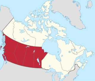
Western Canada, also referred to as the Western provinces and commonly known within Canada as the West, is a Canadian region that includes the four western provinces just north of the Canada-United States border, namely British Columbia, Alberta, Saskatchewan and Manitoba. The people of the region are often referred to as "Western Canadians" or "Westerners", and though diverse from province to province are largely seen as being collectively distinct from other Canadians along cultural, linguistic, socioeconomic, geographic, and political lines. They account for approximately 32% of Canada's total population.

In the 2011 Census, the City of Calgary had a population of 1,096,833 residents, representing 30% of the 3,645,257 residents in all of Alberta, and 3% compared to a population of 33,476,688 in all of Canada. The total population of the Calgary census metropolitan area (CMA) was 1,214,839. Calgary is the largest city in Alberta, and the third-largest municipality and fourth-largest metropolitan area in Canada, as of 2016.
The Canada 1921 census was a detailed enumeration of the Canadian population. The census count was taken as at 1 June 1921. The total population count was 8,788,483 representing a 22% increase over the 1911 Census population count of 7,206,643. The 1921 Census was the sixth comprehensive decennial census since Canadian Confederation on 1 July 1867. The previous census was the Northwest Provinces of Alberta, Saskatchewan, and Manitoba 1916 census and the following census was the Northwest Provinces of Alberta, Saskatchewan, and Manitoba 1926 census.
The 1926 Canadian census was the third of a series of special censuses conducted by the Government of Canada covering the rapidly expanding Northwest Provinces of Alberta, Saskatchewan, and Manitoba. These censuses were conducted every ten years from 1906 to 1946. This census was conducted as at June 1, 1926.
The 1936 Canadian census was the fourth of a series of special censuses conducted by the Government of Canada covering the rapidly expanding Northwest Provinces of Alberta, Saskatchewan, and Manitoba. These censuses were conducted every ten years from 1906 to 1946. This census was conducted as at June 1, 1936.
The 1946 Canadian census was the fifth, and last, of a series of special censuses conducted by the Government of Canada covering the rapidly expanding Northwest Provinces of Alberta, Saskatchewan, and Manitoba. These censuses were conducted every ten years from 1906 to 1946, and ceased when the nationwide census switched from decennial to quinquennial in 1956. This census was conducted as of June 1, 1946.
The 1951 Canadian Census was a detailed enumeration of the Canadian population. The total population count was 14,009,429, representing a 21.8% increase over the 1941 Census population count of 11,506,655. The 1951 Census was the ninth comprehensive decennial census since Canadian Confederation on 1 July 1867.
References
- ↑ "About the 1916 Census". Library and Archives Canada. Retrieved March 14, 2015.
| Ethnic ancestry |
| ||||||||||||||||||||||||||||||||||||||||||||||||||
|---|---|---|---|---|---|---|---|---|---|---|---|---|---|---|---|---|---|---|---|---|---|---|---|---|---|---|---|---|---|---|---|---|---|---|---|---|---|---|---|---|---|---|---|---|---|---|---|---|---|---|---|
| Demographics |
| ||||||||||||||||||||||||||||||||||||||||||||||||||
| Culture and society | |||||||||||||||||||||||||||||||||||||||||||||||||||
| List of Canadians |
| ||||||||||||||||||||||||||||||||||||||||||||||||||