An intraplate earthquake is an earthquake that occurs in the interior of a tectonic plate, in contrast to an interplate earthquake on the boundary of a tectonic plate. It is also called an intraslab earthquake, especially when occurring in a microplate.
Events in the year 1993 in the Republic of India.

The 2001 Gujarat earthquake, also known as the Bhuj earthquake, occurred on 26 January at . The epicentre was about 9 km south-southwest of the village of Chobari in Bhachau Taluka of Kutch (Kachchh) District of Gujarat, India.

Vilasrao Dagadojirao Deshmukh was an Indian politician who served as the 14th Chief Minister of Maharashtra, first term from 18 October 1999 to 16 January 2003 and second term, from 1 November 2004 to 5 December 2008. He also served in the Union cabinet as the Minister of Science and Technology and Minister of Earth Sciences.

Osmanabad District, officially known as Dharashiv District, is an administrative district in the Marathwada region in the Indian state of Maharashtra. The district headquarter is located at Osmanabad. The District of Osmanabad derives its name from the last ruler of Hyderabad, the 7th Nizam, Mir Osman Ali Khan, of which the region was a part till 1947. This region was earlier part of The Hyderabad State until Independence.This primarily rural district occupies an area of 7,569 km2 (2,922 sq mi) of which 241.4 km2 (93.2 sq mi) is urban and has a population of 1,657,576 of which 16.96% were urban.

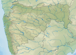
Latur district is a district in Maharashtra state of India. Latur city is the district headquarters and is the 16th largest city in the state of Maharashtra. The district is primarily agricultural. Urban population comprises 25.47% of the total population.
The 1999 Chamoli earthquake occurred on 29 March in the Chamoli district in the Indian state of Uttar Pradesh. Approximately 103 people died in the earthquake.
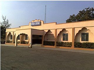
Latur Airport is a public airport located near Chincholiraowadi, 12 kilometres (7.5 mi) west of the city of Latur, in the Marathwada region of the Maharashtra state in India.

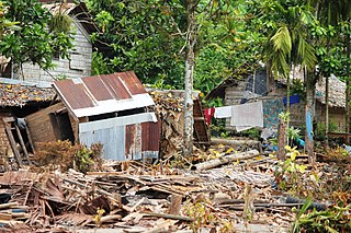
Latur is a city in the Indian state of Maharashtra, and is one of the largest cities of the Marathwada region. It is the administrative headquarters of Latur district and Latur Taluka. The city is a tourist hub surrounded by many historical monuments, including Udgir Fort and Kharosa Caves. The people in Latur are called Laturkar. The most spoken language in Latur is Marathi. The city's quality of education attracts students from all over Maharashtra. It is a drought prone area with acute water shortage in its city and rural areas. The economy is agriculture intensive, but in recent years is also dependent on Educational sector & its allied activities. Industrial development is minimal in the district. Latur is 43 kilometers from the epicenter of the devastating 1993 Latur earthquake.
Latur railway station is a railway station in Central Railway zone which serves the city of Latur, Maharashtra. It is the start of the Latur–Miraj section of the Solapur (SUR) Division of Central Railway (CR). Latur is well connected to Latur Road Junction, Parli Vaijnath, Purna, Hingoli, Washim, Akola, Amravati, Wardha, Nagpur, Nanded, Nizamabad, Osmanabad, Pune, Lonavla, Karjat, Panvel, Thane, Kalyan, Mumbai, Pandharpur, Miraj, Kolhapur, Udgir, Bidar, Vikarabad, Secunderabad, Hyderabad, Yeshwantpur, Bangalore.
Chittenipattu Puthenveettil Rajendran, also known among his peers as CP, is an Indian geoscientist who has worked mainly on the Indian earthquakes and tectonics.
The 2013 Solomon Islands earthquake struck Temotu Province within Solomon Islands on 6 February with a moment magnitude of 8.0 and a maximum Mercalli intensity of VIII (Severe). The epicentre was close to the Santa Cruz Islands within Temotu Province at the boundaries of the Indo-Australian and Pacific tectonic plates, causing local evacuations, a tsunami of 11 m (36 ft) and killing at least ten people.
The 2013 drought in Maharashtra in India came about after the region received lower rainfall during the monsoon season June to September 2012. It is considered as the region's worst drought in 40 years. The worst-hit areas in Maharashtra were Solapur, Parbhani, Ahmednagar, Latur, Pune, Satara, Beed and Nashik. Residents of Latur, Osmanabad, Nanded, Aurangabad, Jalna, Jalgaon and Dhule districts were also affected by this famine.
Umarga (Omerga) Tehsil is a tehsil/ taluka/ subdistrict in Osmanabad district, Maharashtra on the Deccan Plateau of India. The town of Umarga is the administrative headquarters of the tehsil. There are 79 panchayat villages in Umarga Tehsil.
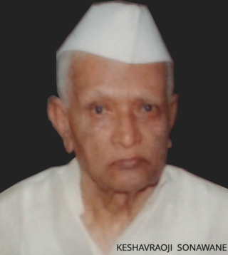
Keshavrao Sonawane (1925–2006) was an Indian politician, who served four terms in the Maharashtra Legislative Assembly, and was a Co-operative minister in Yashwantrao Chavan's cabinet and later Vasantrao Naik's cabinet during 1962–1967. He was elected as Member of Maharashtra Legislative Assembly for 4 times, twice from Latur constituency and twice from Ausa constituency.
Yenegur is a major village located in Omerga tehsil of Osmanabad district, which is part of the Marathwada region of the state of Maharashtra in India.
The 1988 Myanmar–India earthquake, also known as the Indo–Burma earthquake struck the Sagaing Region of Myanmar, about 30 kilometres (19 mi) from the border with India on 6 August at 7:06 am MMT with a moment magnitude (Mw ) of 7.3 or Richter magnitude (ML ) of 7.5. At least five people were killed, more than 30 were injured, and another 30 were missing as a result. Serious damage was reported in India and Bangladesh, while some minor damage occurred in Myanmar. The earthquake was reportedly felt in the Soviet Union.
The 1983 Hindu Kush earthquake occurred south of Fayzabad, Badakhshan in northeast Afghanistan at 03:52 PST on December 31, 1983, near the border with Pakistan and the USSR. Striking 214.5 km beneath the Hindu Kush mountains, the moment magnitude 7.4 quake affected three countries, killing at least 26 people and injuring several hundred.
The 1803 Garhwal earthquake occurred in the early morning of September 1 at 01:30 local time. The estimated 7.8-magnitude-earthquake had an epicenter in the Garhwal Himalaya near Uttarkashi, British India. Major damage occurred in the Himalaya and Indo-Gangetic Plain, with the loss of between 200 and 300 lives. It is among the largest Himalaya earthquakes of the 19th-century, caused by thrust faulting.