Nura is a village in Alay District, Osh Region of Kyrgyzstan, at the point where the A371 road from China turns northwest to go over the pass into the Alay Valley. Its population was 1,101 in 2021. It is at the mouth of a valley that goes south into some glaciated mountains on the Chinese border.

The 2004 Al Hoceima earthquake occurred on 24 February at 02:27:47 local time near the coast of northern Morocco. The strike-slip earthquake measured 6.3 on the moment magnitude scale and had a maximum perceived intensity of IX (Violent) on the Mercalli intensity scale. Between 628 and 631 people were killed, 926 were injured, and up to 15,000 people were made homeless in the Al Hoceima-Imzourene-Beni Abdallah area.
The 2002 Bou'in-Zahra earthquake occurred on 22 June 2002. The epicenter was near the city of Bou'in-Zahra in Qazvin Province, a region of northwestern Iran which is crossed by several major faults that is known for destructive earthquakes. The shock measured 6.5 on the scale, had a maximum Mercalli intensity of VIII (Severe), and was followed by more than 20 aftershocks. At least 230 people were killed and 1,500 more were injured.
The 1997 Ardabil earthquake occurred on 28 February with a moment magnitude of 6.1 and a maximum Mercalli intensity of VIII (Severe). The strike-slip earthquake occurred in northern Iran, near the city of Ardabil.

The 2008 Ziarat earthquakes hit the Pakistani province of Balochistan on October 29 with a moment magnitude of 6.4. The US Geological Survey reported that the first earthquake occurred 60 km (37 mi) north of Quetta and 185 km (115 mi) southeast of the Afghanistan city of Kandahar at 04:09 local time at a depth of 15 km (9.3 mi), at 30.653°N, 67.323°E. It was followed by another shallower magnitude 6.4 earthquake at a depth of 14 km (8.7 mi) approximately 12 hours after the initial shock, at 30.546°N, 67.447°E. 215 people were confirmed dead. More than 200 were injured, and 120,000 were homeless. Qamar Zaman Chaudhry, director general of Pakistan Meteorological Department, stated the quake epicenter was 70 miles (110 km) north of Quetta, and about 600 km (370 mi) southwest of Islamabad.
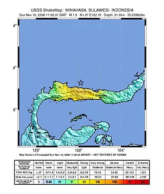
The 2008 Sulawesi earthquake struck Sulawesi, Indonesia, on 16 November at 17:02:31 UTC. A 7.4 earthquake, it was followed by seven aftershocks higher than 5.0 Mw . Tsunami warnings were issued for the region, but later cancelled. Four people were killed in the quake and 59 injured.
The 2009 Cinchona earthquake occurred at on January 8 with an magnitude of 6.1 and a maximum Mercalli intensity of VII. The shock took place in northern Costa Rica, 30 kilometres (19 mi) north-northwest of San José and was felt throughout Costa Rica and in southern central Nicaragua.
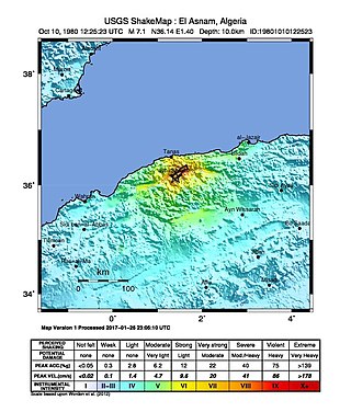
The 1980 El Asnam earthquake occurred on October 10 at with a moment magnitude of 7.1 and a maximum Mercalli intensity of X (Extreme). The shock occurred in the Algerian town of El Asnam. The shocks were felt over 550 km (340 mi) away, with the initial earthquake lasting 35 seconds. It was the largest earthquake in Algeria, and was followed three hours later by a magnitude 6.2 aftershock. The earthquake created about 42 km (26 mi) of surface rupture and had a vertical slip of up to 4.2 m (14 ft). No foreshocks were recorded. The earthquake was found to have occurred very close to the epicenter of the 1954 Chlef earthquake using joint epicenter determination techniques. It occurred at a previously unknown reverse fault.
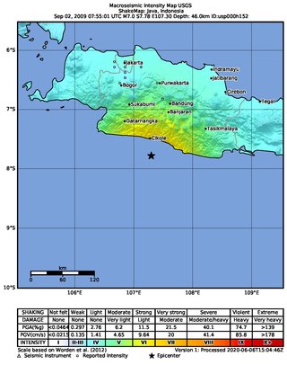
An earthquake occurred on September 2, 2009 at 14:55:01 local time in West Java, Indonesia. The magnitude 7.0 earthquake killed at least 81 people, injured over 1,297, and displaced over 210,000. The quake was felt in the capital Jakarta, although damage there was minimal, and it was Indonesia's deadliest earthquake since the 2006 Pangandaran earthquake and tsunami.
The 2010 Elazığ earthquake was a 6.1 Mw earthquake that occurred on 8 March 2010 at 02:32 UTC. The epicentre was Başyurt in Elazığ Province, in eastern Turkey. Initial reports in global media said as many as 57 people had died. By 10 March, reports in the Turkish media placed the death toll at 41 and later, the death toll rose to 42. Another 74 were injured, many after falling and jumping from buildings. A stampede through the streets led to further injuries.
The 2010 Papua earthquake occurred on June 16 at 12:16 local time in Papua province of Indonesia. The magnitude 7.0 mainshock was preceded by an 6.2 foreshock 10 minutes earlier, and was followed 42 minutes later by an Mw 6.6 aftershock.
The 1982 Flores earthquake struck the island of Flores in Indonesia on December 25. Registering a moment magnitude of 5.9, according to the International Seismological Centre, it created landslides and was reportedly accompanied by a tsunami. The earthquake killed thirteen people and left 390 injured, also destroying 1,875 houses and 121 other buildings. The villages of Layahong and Oyong Barang were damaged by seven seconds of shaking.

The 2013 Bushehr earthquake occurred with a moment magnitude of 6.3 on April 9 in Iran. The shock's epicenter was in the province of Bushehr, near the city of Khvormuj and the towns of Kaki and Shonbeh. At least 37 people were killed, mostly from the town of Shonbeh and villages of Shonbeh-Tasuj district, and an estimated 850 people were injured.

The 2014 Orkney earthquake occurred at 12:22:33 SAST on 5 August, with the epicentre near Orkney, a gold mining town in the Klerksdorp district in the North West province of South Africa. The shock was assigned a magnitude of 5.5 on the Richter scale by the Council for Geoscience (CGS) in South Africa, making it the biggest earthquake in South Africa since the 1969 Tulbagh earthquake, which had a magnitude of 6.3 on the Richter scale. The United States Geological Survey (USGS) estimated a focal depth of 5.0 km (3.1 mi). The CGS reported 84 aftershocks on 5 August and 31 aftershocks on 6 August, with a magnitude of 1.0 to 3.8 on the Richter scale. According to the CGS, the earthquake is the biggest mining-related earthquake in South African history.

The October 2015 Hindu Kush earthquake was a magnitude 7.5 earthquake that struck South Asia on 26 October 2015, at 13:39 AFT with the epicenter 45 km north of Kuran wa Munjan, Afghanistan, at a depth of 231.0 km.
On December 7, 2015, an earthquake measuring 7.2 on the moment magnitude scale struck Tajikistan 105 km (65 mi) west of Murghab at 07:50 UTC at a depth of 26.0 km (16.2 mi). The earthquake was also felt in neighboring Xinjiang in China, India, Afghanistan, Pakistan and Kyrgyzstan.

On May 4, 2018, an earthquake with a magnitude of 6.9 struck Hawaii island in the Hawaii archipelago at around 12:33 p.m. local time. The earthquake's epicenter was near the south flank of Kīlauea, which has been the site of seismic and volcanic activity since late April of that year. According to the United States Geological Survey the quake was related to the new lava outbreaks at the volcano, and it resulted in the Hilina Slump moving about two feet. It was the largest earthquake to affect Hawaii since the 1975 earthquake, which affected the same region, killing two people and injuring another 28.
The 2019 Cotabato earthquakes were an earthquake swarm which struck the province of Cotabato on the island of Mindanao in the Philippines in October 2019. Three of these earthquakes were above 6.0 on the moment magnitude scale with a Mercalli intensity of VIII. More than 40 people have been reported dead or missing and nearly 800 were injured as a result of these events.
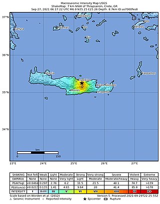
A moment magnitude 6.0 earthquake struck the island of Crete in Greece at a depth of 6 km on 27 September 2021. The epicenter of the earthquake was located southeast of Heraklion. The quake killed one person, injured 36 and damaged over 5,000 old buildings on the island.
