2014 Orkney earthquake

Last updated

2014 Orkney earthquake
ShakeMap Orkney 5 August 2014.jpg
USGS ShakeMap illustrating the intensity of the earthquake
South Africa relief location map.svg
Blue pog.svg
Orkney
UTC  time2014-08-05 10:22:33
ISC  event 610571677
USGS-ANSS ComCat
Local date5 August 2014 (2014-08-05)
Local time12:22:33 SAST (UTC+02:00) [1]
Magnitude5.5 ML [2]
Depth5.0 km (3.1 mi) [1] [3]
Epicenter 26°58′18″S26°42′34″E / 26.9717°S 26.7094°E / -26.9717; 26.7094 Coordinates: 26°58′18″S26°42′34″E / 26.9717°S 26.7094°E / -26.9717; 26.7094 [1]
Areas affected South Africa, also felt in Botswana, Swaziland, Lesotho and Mozambique
Max. intensity VI (Strong) [1]
Foreshocks4.9 MW at 16:16:25 SAST on 15 June 2014 [4]
Aftershocks3.8 ML at 16:58:42 SAST on 5 August 2014 [5]
Casualties1 dead [6] 34 injured [6] [7]

The 2014 Orkney earthquake occurred at 12:22:33 SAST on 5 August, with the epicentre near Orkney, a gold mining town in the Klerksdorp district in the North West province of South Africa. The shock was assigned a magnitude of 5.5 on the Richter scale by the Council for Geoscience (CGS) in South Africa, [2] [8] [9] making it the biggest earthquake in South Africa since the 1969 Tulbagh earthquake, [10] which had a magnitude of 6.3 on the Richter scale. [11] The United States Geological Survey (USGS) estimated a focal depth of 5.0 km (3.1 mi). [1] The CGS reported 84 aftershocks on 5 August and 31 aftershocks on 6 August, with a magnitude of 1.0 to 3.8 on the Richter scale. [5] According to the CGS, the earthquake is the biggest mining-related earthquake in South African history. [3]

Contents

Cause

USGS seismicity map for South Africa Seismicity map South Africa.jpg
USGS seismicity map for South Africa

Historical seismicity

While earthquakes are uncommon in South Africa in general, [12] the earthquake occurred in a mining belt where earthquakes are relatively common. [13] The CGS had described a 2005 earthquake with a magnitude of 5.3 on the Richter scale in the same area as Orkney as "the largest mining-related earthquake in South Africa". [14] The earthquake occurred on 9 March 2005 at DRDGOLD's Hartebeesfontein mine in Stilfontein, [15] killing two miners underground and resulting in the closure of the mine. [8] [13] [16] [17] An investigation by the mining regulator following the incident found that it was caused by mining and further seismic events would occur while mining continued. The report on the investigation recommended improvements in seismic monitoring among other things, [18] [19] and some of the recommendations had been implemented before the 2014 earthquake. [20] The USGS recorded a 4.9 moment magnitude earthquake on 15 June 2014 in the same area, which earth science consultant Dr Chris Hartnady believes may have been a foreshock. [13] [16]

Expert opinions

While both mining activity and natural faults could be causative factors, it is difficult to establish a precise cause. [10] [21] According to Professor Andrzej Kijko from the University of Pretoria's Natural Hazard Centre, mining can activate natural faults. He believes that more than 90% of South Africa's earthquakes are caused by mining, especially around the areas of Klerksdorp, Carletonville and Welkom. [13] [20] [22] According to Hartnady, "This part of Africa is in the vicinity of the East African Rift system, which is being pulled apart by a few millimetres annually." He says "earthquakes are caused by a slip on a fault line and the release of stored elastic energy" and mining activity could have triggered the earthquake. [13] [23] Kijko and Hartnady believe that – unlike the 1969 Tulbagh earthquake – this event was a mining-related earthquake which is a relatively more common occurrence than a natural earthquake in South Africa. [16] [22] [23] Professor Ray Durrheim, a seismologist at Wits University, said seismic events will continue while there is mining activity in the area, [3] and even long afterwards. He said the flooding of inactive mines could also compound pressure on geological faults, triggering further seismic events. [20] According to Durrheim, the link between mining and earthquakes lies "on a continuum, from where it's purely induced by mining activities to where you are triggering a natural earthquake". [24]

Council for Geoscience

According to Michelle Grobbelaar from the CGS, "There's a rule of thumb that if you experience an earthquake with a certain magnitude in the past, you can always expect an earthquake of a similar magnitude in that same area." [25] Grobbelaar and Denver Birch, also from the CGS, said that the cause of the earthquake was difficult to determine given that it occurred in a mining area and the lack of historical seismic data for the area. [26] [27] Ian Saunders from the CGS confirmed that a team would be sent to the area for further investigation, [13] and Eldridge Kgaswane from the CGS said they should be able to determine the cause within a month. According to Kgaswane, "The fact that the deepest mine shafts are shallower than the epicentre doesn't mean mining can be ruled out as a cause. Blasting in the vicinity of a big fault could have activated seismic activity." [10] On 18 August 2014 at a Council for Scientific and Industrial Research (CSIR) seminar in Pretoria, the CGS confirmed that the earthquake was caused by mining-related activity, making it the biggest ever mining-related earthquake recorded in South Africa. [3]

Impact

Orkney, North West Station Orkney NW.JPG
Orkney, North West

The earthquake occurred at 12:22:33 SAST on 5 August 2014, with the epicentre near Orkney, a gold mining town in the Klerksdorp district in the North West province of South Africa. The shock was assigned a magnitude of 5.5 on the Richter scale by the Council for Geoscience (CGS) in South Africa, [2] [8] [9] making it the biggest earthquake in South Africa since the 1969 Tulbagh earthquake, [10] which had a magnitude of 6.3 on the Richter scale. [11] The United States Geological Survey (USGS) estimated a focal depth of 5.0 km (3.1 mi). [1] The CGS reported 84 aftershocks on 5 August and 31 aftershocks on 6 August, with a magnitude of 1.0 to 3.8 on the Richter scale. [5]

Areas affected

The earthquake was felt as far as 600 km (370 mi) from Orkney. [13] [28] It was felt in neighbouring countries Botswana, Swaziland, Lesotho and Mozambique. [22] [29] [30] The two tallest buildings in Bloemfontein, the former CR Swart Building and the Lebohang building, [31] as well as tall buildings and University of Pretoria halls in Pretoria and offices of the South African Revenue Service in Durban were evacuated. [13] [32] [33] According to Michelle Grobbelaar, manager of the CGS's seismology unit, the earthquake was felt in Durban because "the beach sand tends to amplify the ground motion". [34] Buildings in Maputo in Mozambique were also evacuated. [35] The Meteorological Services of Zimbabwe confirmed that Zimbabwe was not affected by the earthquake. [36]

Casualties

There was a single fatality, 31-year-old Mosotho man Leshomo Makhaola, who died when a wall of an old mining house collapsed on him in Kanana, North West. [22] [28] [37] [38] An ER24 spokesperson said that miners had reportedly been trapped in 11 mine shafts at a mine in Orkney; [39] however, subsequent inspections revealed that the miners at that location were safe. [7] [30] All 3,300 AngloGold Ashanti miners underground at its Great Noligwa and Moab Khotsong mines near Orkney had been brought to the surface by 19:30 SAST on 5 August, including 34 who had been injured. [7] [40] All 34 miners were treated for minor injuries, including lacerations, contusions and a broken leg, [13] [40] and discharged from hospital on 6 August. [41] AngloGold Ashanti management had proceeded with the evacuation after their temporarily interrupted power supply was mostly restored, mine management had contacted the mine crew underground by telephone and mine engineers had ensured that the shaft infrastructure was in working order. [40] [42] AngloGold Ashanti emergency medical staff had treated injured miners, [13] and counsellors had treated some employees for shock. [42] Mining operations at their Great Noligwa and Moab Khotsong mines were subsequently suspended pending safety checks. [22] [41] [42]

Damage

There was extensive damage to buildings in Orkney and the surrounding areas, partly due to inadequate building construction vulnerable to earthquake damage. [20] [43] The Khuma township near Stilfontein was one of the worst affected areas, with more than 600 homes damaged by the earthquake. [44] [45] An aftershock occurred in Khuma in the afternoon of 5 August while residents were assessing the damage to their homes. [46] [47] Three clinics in the North West province were damaged, leading to the closure of two of them. [7] [48] Two schools were damaged and some pupils were unable to attend classes as the classrooms were too badly damaged. [49]

In the days following the earthquake, most of South Africa's major banks and insurance companies had begun receiving insurance claims. [45] By 6 August 2014, ABSA had received 200 claims, Standard Bank had received 129 claims and Mutual & Federal had received 11 claims. [50] A survey of 17 insurance companies done by finance website Justmoney showed that 5 out of the 17 companies surveyed would reject insurance claims related to the earthquake if it was proven to be mining-related. [51] In a response to the Survey, ABSA, who was on the list of 5, affirmed that they have received approximately 1100 claims and were in the process of finalising them. [52]

Response

The CGS warned that aftershocks were expected in the days following the earthquake and they could possibly continue for months. They recommended that buildings be evacuated in the event of an aftershock. [8] [22] The mining regulator's chief inspector of mines David Msiza asked mining companies in affected areas, including Klerksdorp, Carletonville and Rustenburg, to undertake underground inspections to ensure no miners were trapped and the working conditions were safe for miners. [40] AngloGold Ashanti denied responsibility for the earthquake, saying it occurred away from its mining infrastructure. [10]

Premier of North West Supra Mahumapelo promised residents that all who were affected by the earthquake would receive help. [53] Mahumapelo said that counselling, social relief and temporary accommodation were being provided, [44] and that the buildings and infrastructure damaged in the earthquake might take years to repair. [54] The North West provincial government started the North West Disaster Relief Fund to help residents affected by the earthquake. [38] Teams were sent to investigate damage to parts of the Dr Kenneth Kaunda District Municipality by the municipality. [55] The Cabinet of South Africa sent its condolences to the family of the man who was killed by the earthquake. [38]

On 30 September 2014, the Inkatha Freedom Party expressed its concern for the residents of Khuma as repairs to their homes were delayed and had not yet commenced. Provincial government spokesperson, Bonolo Mohlakoana said that construction was delayed partly due to a lack of structural engineers, which were needed to assess the structural damage caused to the houses. [56] Several families affected by the earthquake moved to a community centre while waiting for their houses to be repaired after affected families were instructed to move to safer locations. [57]

See also

Related Research Articles

<span class="mw-page-title-main">Earthquake swarm</span> Series of localized seismic events within a short time period

In seismology, an earthquake swarm is a sequence of seismic events occurring in a local area within a relatively short period of time. The length of time used to define a swarm varies, but may be days, months, or years. Such an energy release is different from the situation when a major earthquake is followed by a series of aftershocks: in earthquake swarms, no single earthquake in the sequence is obviously the main shock. In particular, a cluster of aftershocks occurring after a mainshock is not a swarm.

<span class="mw-page-title-main">Orkney, North West</span> Place in North West, South Africa

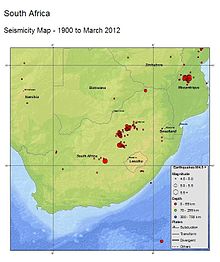
Orkney is a gold mining town situated in the Klerksdorp district of the North West province, South Africa. It lies on the banks of the Vaal River approximately 180 km from Johannesburg near the N12.

The 1989 Newcastle earthquake was an intraplate earthquake that occurred in Newcastle, New South Wales on Thursday 28 December. The shock measured 5.6 on the Richter magnitude scale and was one of Australia's most serious natural disasters, killing 13 people and injuring more than 160. The damage bill has been estimated at A$4 billion, including an insured loss of about $1 billion.

<span class="mw-page-title-main">2005 Fukuoka earthquake</span> Earthquake in Japan

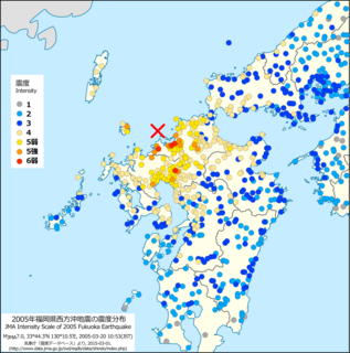
The Fukuoka earthquake struck Fukuoka Prefecture, Japan at 10:53 am JST on March 20, 2005, and lasted for approximately 1 minute. The Japan Meteorological Agency (JMA) measured it as peaking at a magnitude of 7.0, whereas the United States Geological Survey (USGS) reported a magnitude of 6.6. The quake occurred along a previously unknown fault in the Genkai Sea, North of Fukuoka city, and the residents of Genkai Island were forced to evacuate as houses collapsed and landslides occurred in places. Investigations subsequent to the earthquake determined that the new fault was most likely an extension of the known Kego fault that runs through the centre of the city.

<span class="mw-page-title-main">1886 Charleston earthquake</span> Earthquake in South Carolina, United States

The 1886 Charleston earthquake occurred about 9:50 p.m. local time August 31. It caused 60 deaths and $5–6 million in damage to 2,000 buildings in the Southeastern United States. It is one of the most powerful and damaging earthquakes to hit the East Coast of the United States.

<span class="mw-page-title-main">1993 Scotts Mills earthquake</span> Earthquake in Oregon

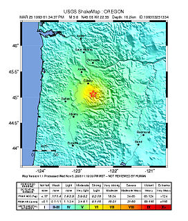
The 1993 Scotts Mills earthquake, also known as the "Spring break quake", occurred in the U.S. state of Oregon on March 25 at 5:34 AM Pacific Standard Time. With a moment magnitude of 5.6 and a maximum perceived intensity of VII on the Mercalli intensity scale, it was the largest earthquake in the Pacific Northwest since the Elk Lake and Goat Rocks earthquakes of 1981. Ground motion was widely felt in Oregon's Willamette Valley, the Portland metropolitan area, and as far north as the Puget Sound area near Seattle, Washington.

The 2008 Illinois earthquake was one of the largest earthquakes ever recorded in the Midwest state of Illinois. This moderate strike-slip shock measured 5.2 on the moment magnitude scale and had a maximum Mercalli intensity of VII (Very strong). It occurred at 04:36:59 local time on April 18 near West Salem and Mount Carmel, Illinois, within the Wabash Valley Seismic Zone. Earthquakes in this part of the country are often felt at great distances.

<span class="mw-page-title-main">1983 Coalinga earthquake</span> Earthquake affecting Central California

The 1983 Coalinga earthquake struck at 4:42 p.m. Monday, May 2 of that year, in Coalinga, California.

<span class="mw-page-title-main">2008 Chino Hills earthquake</span>

The 2008 Chino Hills earthquake occurred at 11:42:15 am PDT on July 29 in Southern California. The epicenter of the magnitude 5.4 earthquake was in Chino Hills, c. 28 miles (45 km) east-southeast of downtown Los Angeles. Though no lives were lost, eight people were injured, and it caused considerable damage in numerous structures throughout the area and caused some amusement park facilities to shut down their rides. The earthquake led to increased discussion regarding the possibility of a stronger earthquake in the future.

<span class="mw-page-title-main">2010 Baja California earthquake</span> Earthquake in Mexico

The 2010 Baja California earthquake occurred on April 4 with a moment magnitude of 7.2 and a maximum Mercalli intensity of VII. The shock originated at 15:40:41 local time south of Guadalupe Victoria, Baja California, Mexico.

<span class="mw-page-title-main">2010 Pichilemu earthquakes</span> 6.9 and 7.0 MW intraplate earthquakes 2010 in Chile

The 2010 Pichilemu earthquakes, also known as the Libertador O'Higgins earthquakes, were a pair of intraplate earthquakes measuring 6.9 and 7.0 Mw that struck Chile's O'Higgins Region on 11 March 2010 about 16 minutes apart. The earthquakes were centred 15 kilometres (9.3 mi) northwest of the city of Pichilemu.

<span class="mw-page-title-main">2011 Virginia earthquake</span> Earthquake in Virginia, U.S.

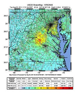
On August 23, 2011, a magnitude 5.8 earthquake hit the Piedmont region of the U.S. state of Virginia at 1:51:04 p.m. EDT. The epicenter, in Louisa County, was 38 mi (61 km) northwest of Richmond and 5 mi (8 km) south-southwest of the town of Mineral. It was an intraplate earthquake with a maximum perceived intensity of VIII (Severe) on the Mercalli intensity scale. Several aftershocks, ranging up to 4.5 Mw in magnitude, occurred after the main tremor.

<span class="mw-page-title-main">2011 Oklahoma earthquake</span> 2011 earthquake near Prague, Oklahoma

The 2011 Oklahoma earthquake was a 5.7 magnitude intraplate earthquake which occurred near Prague, Oklahoma on November 5 at 10:53 p.m. CDT in the U.S. state of Oklahoma. The epicenter of the earthquake was in the vicinity of several active wastewater injection wells. According to the United States Geological Survey (USGS), it was the most powerful earthquake ever recorded in Oklahoma; this record was surpassed by the 2016 Oklahoma earthquake. The previous record was a 5.5 magnitude earthquake that struck near the town of El Reno in 1952. The quake's epicenter was approximately 44 miles (71 km) east-northeast of Oklahoma City, near the town of Sparks and was felt in the neighboring states of Texas, Arkansas, Kansas and Missouri and even as far away as Tennessee and Wisconsin. The quake followed several minor quakes earlier in the day, including a 4.7 magnitude foreshock. The quake had a maximum perceived intensity of VIII (Severe) on the Mercalli intensity scale in the area closest to the epicenter. Numerous aftershocks were detected after the main quake, with a few registering at 4.0 magnitude.

The 1993 Klamath Falls earthquakes took place in Klamath Falls, Oregon, beginning on Monday, 20 September at 8:28 p.m. The doublet earthquake registered respective magnitudes of 6.0 and 5.9 on the moment magnitude scale. The earthquakes were located at a depth of 5.6 miles (9 km) and tremors continued to be felt more than three months after the initial shocks.

The 1965 Valparaíso earthquake struck near the city of La Ligua in the Valparaíso Region, Chile, about 140 kilometers from the capital Santiago on Sunday, March 28 at 12:33 p.m. (UTC−03:00). The moment magnitude Mw  7.4–7.6 temblor killed an approximate 500 people and caused damages amounting to some US$1 billion. Many of the deaths were from El Cobre, a mining location that was wiped out after a series of dam failures caused by the earthquake spilled mineral waste onto the area, burying hundreds of residents. The shock was so powerful that it could be felt throughout the country and even across the continent to the Atlantic coast of Argentina.

The 1990 Carlentini earthquake occurred off the Sicilian coast, 20 km east northeast from the town of Augusta, Sicily on 13 December at 01:24 local time. The moderately-sized earthquake measuring 5.6 on the moment magnitude scale (Mw ) resulted in the deaths of 19 people and caused at least 200 injuries. It also inflicted significant damage in the region, leaving 2,500 homeless.

An earthquake struck approximately 53 kilometres SSE of the town of Mansfield, in the Victorian Alps of Australia on 22 September 2021, at 09:15 local time. The earthquake measured 5.9 on the moment magnitude scale. The earthquake caused minor structural damage in parts of Melbourne and left one person injured. The earthquake was also felt in New South Wales, Australian Capital Territory, South Australia and Tasmania. The earthquake was substantially stronger than the 1989 Newcastle earthquake that measured 5.6 and killed 13 people.

The 2021 Lasithi earthquake was a magnitude 6.4 Mw earthquake with a maximum intensity of VIII (Severe) on the Modified Mercalli Intensity Scale which occurred on October 12, 2021, 12:24 (UTC+3:30) off the island of Crete. The quake was also felt at low intensity as far as Cairo and Istanbul.

References

  1. 1 2 3 4 5 6 "M5.4 – 3km ENE of Orkney, South Africa". United States Geological Survey. Archived from the original on 8 August 2014. Retrieved 16 October 2014.
  2. 1 2 3 "5.5 Magnitude Quake hits South Africa". CGS. Archived from the original on 12 August 2014. Retrieved 7 August 2014.
  3. 1 2 3 4 Bateman, Barry (18 August 2014). "SA earthquake was mine-related". EWN. Archived from the original on 19 August 2014. Retrieved 18 August 2014.
  4. "M4.9 – 8km E of Orkney, South Africa (BETA)". United States Geological Survey. Archived from the original on 16 August 2014. Retrieved 16 August 2014.
  5. 1 2 3 "Today, the third day after the earthquake, the aftershocks continue". CGS. Archived from the original on 19 August 2014. Retrieved 16 August 2014.
  6. 1 2 "More aftershocks expected". News24. 6 August 2014. Archived from the original on 10 August 2014.
  7. 1 2 3 4 "Quake injures 34 AngloGold miners". Fin24. SAPA. 6 August 2014. Archived from the original on 12 August 2014. Retrieved 6 August 2014.
  8. 1 2 3 4 Raaff, Miranda (5 August 2014). "Quake measured 5.5: SA council". IOL. Archived from the original on 8 August 2014. Retrieved 6 August 2014.
  9. 1 2 "Intensity". CGS. Archived from the original on 14 August 2014. Retrieved 14 August 2014. The Seismology Unit of the Council for Geoscience uses the Richter Scale, also known as the local magnitude scale, to determine the size of earthquakes.
  10. 1 2 3 4 5 Crowley, Kevin (11 August 2014). "AngloGold Rejects Blame for Quake Even as Scientists Await Proof". Bloomberg. Archived from the original on 19 August 2014. Retrieved 17 August 2014.
  11. 1 2 Gifford, Gill (5 August 2014). "Disaster teams out in full after SA quake". eNCA . Archived from the original on 8 August 2014. Retrieved 6 August 2014.
  12. "More tremors rock Stilfontein after quake". IOL. SAPA. 9 March 2005. Archived from the original on 19 August 2014. Retrieved 18 August 2014.
  13. 1 2 3 4 5 6 7 8 9 10 Hosken, Graeme; Smillie, Shaun; Child, Katharine; Louw, Poppy; Masombuka, Sipho (6 August 2014). "Quake of shaky things to come". Times LIVE. Archived from the original on 19 August 2014. Retrieved 6 August 2014.
  14. "The Stilfontein Earthquake". CGS. Archived from the original on 19 August 2014. Retrieved 15 August 2014.
  15. Templeton, Alameen; Tau, Poloko; Ancer, Jonathan (23 March 2005). "DRDGold 'doing the dirty' to Stilfontein". IOL. Archived from the original on 19 August 2014. Retrieved 18 August 2014.
  16. 1 2 3 le Cordeur, Matthew (6 August 2014). "Did mining cause SA quake?". Fin24. Archived from the original on 12 August 2014. Retrieved 14 August 2014.
  17. "Media Update: 5.5 magnitude earthquake – tremors continue". CGS. Archived from the original on 14 August 2014. Retrieved 14 August 2014.
  18. Mawson, Nicola (9 October 2005). "Expert team to tackle SA mining's seismic challenges". Mining Weekly. Archived from the original on 4 March 2016. Retrieved 18 August 2014.
  19. Webb, Mariaan (21 August 2006). "Study calls for improved seismic monitoring". Mining Weekly. Archived from the original on 4 March 2016. Retrieved 18 August 2014.
  20. 1 2 3 4 Kolver, Leandi (18 August 2014). "More than 90% of SA seismic events are mining related – professor". Mining Weekly. Archived from the original on 22 December 2015. Retrieved 19 August 2014.
  21. "Earthquakes – mining or nature?". CSIR. 25 August 2014. Archived from the original on 7 January 2015. Retrieved 7 January 2015.
  22. 1 2 3 4 5 6 "Brace for more quake shakes". The Star. SAPA. 6 August 2014. Archived from the original on 14 August 2014. Retrieved 14 August 2014.
  23. 1 2 Seale, Lebogang (6 August 2014). "Quake triggered by mine activity – expert". The Star. Archived from the original on 14 August 2014. Retrieved 14 August 2014.
  24. Wakefield, Adam (18 August 2014). "Quake possibly linked to mining – prof". Business Report. Archived from the original on 19 August 2014. Retrieved 19 August 2014.
  25. Kubheka, Thando; Kalenga, Aurelie (6 August 2014). "Earthquake: Aftershocks Imminent". EWN. Archived from the original on 10 August 2014. Retrieved 15 August 2014.
  26. "Update: Cause of the earthquake difficult to determine". Sandton Chronicle. 5 August 2014. Archived from the original on 7 August 2014. Retrieved 15 August 2014.
  27. Mosamo, Sebabatso (6 August 2014). "Cause of SA Earthquake Uncertain". EWN. Archived from the original on 10 August 2014. Retrieved 15 August 2014.
  28. 1 2 "Quake kills one and injures multiple mineworkers". Mining News. 6 August 2014. Archived from the original on 16 August 2014. Retrieved 16 August 2014.
  29. "Miners treated for injuries following quake". SABC News. 5 August 2014. Archived from the original on 14 August 2014. Retrieved 14 August 2014.
  30. 1 2 "Earthquake shakes South Africa killing one". BBC News. 5 August 2014. Archived from the original on 8 August 2014. Retrieved 6 August 2014.
  31. "Quake empties Bloem's tall buildings". IOL. SAPA. 5 August 2014. Archived from the original on 8 August 2014. Retrieved 7 August 2014.
  32. "SA earthquake claims first life". EWN. 5 August 2014. Archived from the original on 9 August 2014. Retrieved 5 August 2014.
  33. Rondganger, Lee (6 August 2014). "Quake sets off ripple of fear". Daily News. Archived from the original on 14 August 2014. Retrieved 14 August 2014.
  34. Coan, Stephen (6 August 2014). "Why Durban felt the quake". The Witness. Archived from the original on 19 August 2014. Retrieved 18 August 2014.
  35. "SA earthquake big, but not uncommon". Mail & Guardian. SAPA. 5 August 2014. Archived from the original on 10 August 2014. Retrieved 15 August 2014.
  36. Chikwati, Elita (6 August 2014). "Zimbabwe: SA Earthquake – Zim Safe". The Herald . Archived from the original on 8 August 2014. Retrieved 8 August 2014.
  37. "Man rescued from collapsed house after quake". News24. SAPA. 5 August 2014. Archived from the original on 10 August 2014.
  38. 1 2 3 "Cabinet sends condolences to family of quake victim". South African Government News Agency. 7 August 2014. Archived from the original on 11 August 2014. Retrieved 7 August 2014.
  39. "Miners trapped after 5.3 earthquake hits South Africa". News24. South African Press Association. 5 August 2014. Archived from the original on 8 August 2014. Retrieved 5 August 2014.
  40. 1 2 3 4 Cokayne, Roy; Faku, Dineo (6 August 2014). "Miners, markets survive earthquake". Business Report. Archived from the original on 26 August 2014. Retrieved 18 August 2014.
  41. 1 2 "34 Miners discharged from hospital after earthquake". The Sowetan. SAPA. 6 August 2014. Archived from the original on 10 August 2014. Retrieved 7 August 2014.
  42. 1 2 3 "Safety protocols worked in quake evacuation says Anglogold". Business Day. 7 August 2014. Archived from the original on 4 July 2015. Retrieved 7 August 2014.
  43. "Mining to blame for major quake". Pretoria News. 19 August 2014. Archived from the original on 26 August 2014. Retrieved 22 August 2014.
  44. 1 2 "Relief fund opened for North West quake victims". News24. SAPA. 7 August 2014. Archived from the original on 10 August 2014. Retrieved 8 August 2014.
  45. 1 2 Shevel, Adele (10 August 2014). "Insurers brace for a wave of quake claims". Business Day. Archived from the original on 19 August 2014. Retrieved 15 August 2014.
  46. "Residents scramble as aftershock hits". News24. 5 August 2014. Archived from the original on 7 August 2014. Retrieved 5 August 2014.
  47. "Earthquake aftershock hits Orkney township". City Press. 5 August 2014. Archived from the original on 10 August 2014. Retrieved 6 August 2014.
  48. "Three North West clinics damaged in SA quake". eNCA . 6 August 2014. Archived from the original on 8 August 2014. Retrieved 7 August 2014.
  49. "Pupils miss class due to quake damage". News24. SAPA. 6 August 2014. Archived from the original on 10 August 2014. Retrieved 6 August 2014.
  50. Molosankwe, Botho (7 August 2014). "Claims pouring in after quake". IOL. SAPA. Archived from the original on 14 August 2014. Retrieved 7 August 2014.
  51. "South African insurers won't pay for quake damage". Times Live. SAPA. 27 August 2014. Retrieved 28 August 2014.
  52. "Absa: We do cover quake damage". fin24. 28 August 2014.
  53. Mosamo, Sebabatso (6 August 2014). "Cause of SA earthquake uncertain". EWN. Archived from the original on 8 August 2014. Retrieved 6 August 2014.
  54. "Disaster relief fund to assist earthquake victims". EWN. 6 August 2014. Archived from the original on 9 August 2014. Retrieved 8 August 2014.
  55. Sello, Lenyaro (6 August 2014). "Fear grips Orkney community after earthquake". eNCA. Archived from the original on 19 August 2014. Retrieved 16 August 2014.
  56. "IFP concerned over quake victims". News24. SAPA. Archived from the original on 6 October 2014. Retrieved 4 October 2014.
  57. "Govt abandoned us after earthquake – Khuma residents". The Citizen. SAPA. 23 September 2014. Archived from the original on 21 October 2014. Retrieved 17 October 2014.