Saskatchewan Highway 7 is a major paved undivided provincial highway in the Canadian province of Saskatchewan, running from the Alberta border to Saskatoon. Highway 7 continues west into Alberta where it becomes Alberta Highway 9.
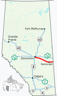
Alberta Provincial Highway No. 14, commonly referred to as Highway 14, is an east-west highway in central Alberta, Canada. It stretches from Edmonton through Wainwright to the Alberta–Saskatchewan border, running parallel to the more northern Highway 16. Highway 14 is about 257 kilometres (160 mi) long.
Highway 219 is a secondary highway in the Canadian province of Saskatchewan, running from the Gardiner Dam development and the north end of Lake Diefenbaker north to Saskatoon.
Highway 14 is a highway in the Canadian province of Saskatchewan. It runs from the Alberta border where it becomes Highway 13 to intersection of Circle Drive and 22nd Street in Saskatoon. It is approximately 250 km (160 mi) long.
Highway 684 is the name given to two different highways in the Canadian province of Saskatchewan.
Confederation Suburban Centre is a community in the city of Saskatoon, Saskatchewan, which consists primarily of commercial development.

Blairmore Suburban Development Area (SDA) is an area in Saskatoon, Saskatchewan (Canada). It is a part of the west side community of Saskatoon. It lies (generally) north of the outskirts of the City and the Rural Municipality of Corman Park No. 344, west of downtown Saskatoon, and the Core Neighbourhoods SDA, south of the North West Industrial SDA, and west of the Confederation SDA. Most of the Blairmore SDA consists of undeveloped land annexed by the city in the mid-2000s. A total of nine neighbourhoods, primarily residential in nature, are ultimately planned for the SDA. As of late 2019, two are in the process of development: the commercial/residential Blairmore Suburban Centre and the residential community Kensington. A third residential area, Elk Point, is also in its early stages.

The Blairmore Suburban Centre is a community service/commercial/residential community currently under development in western Saskatoon, Saskatchewan. It is part of the city's Blairmore Suburban Development Area, a large region annexed from the Rural Municipality of Corman Park No. 344 in 2005. Ultimately, the SDA will consist of seven new neighbourhoods, plus the Blairmore Suburban Centre, which is the first component of the SDA to be developed.
8th Street East is an arterial road serving the city of Saskatoon, Saskatchewan. It begins as a continuation of a minor residential street at Lorne Avenue in Saskatoon, and runs through the eastern part of city, eventually exiting the city limits as a country road.

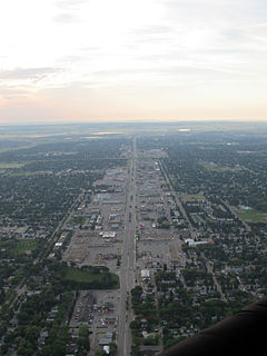
Circle Drive is a major road constructed as a ring road in Saskatoon, Saskatchewan, Canada. Its route constitutes both part of the Yellowhead Highway and Highway 11, signed as both along the entire length. It was first conceived in 1913 by the city commissioner and completed exactly 100 years later in 2013. Most of the route is a fully-controlled access freeway, however the segment between Airport Drive and Millar Avenue has at-grade intersections.

Idylwyld Drive is an arterial road in Saskatoon, Saskatchewan. It is one of the main roads in and out of the downtown area of the city.
Terwillegar Drive is a developing freeway in south-west Edmonton, Alberta. It is under construction, with the majority of its intersection at-grade, it retains its arterial road status. Once completed, it will be the third freeway in Edmonton not to have a highway designation after Groat Road and Wayne Gretzky Drive. South of Windermere Boulevard the roadway goes by 170 Street SW.
97/98/101 Avenue and Baseline Road is a major arterial road in central Edmonton and north Sherwood Park, Alberta. It connects Downtown Edmonton with the mature residential neighborhoods on the city's eastern edge, as well as Refinery Row and Sherwood Park.
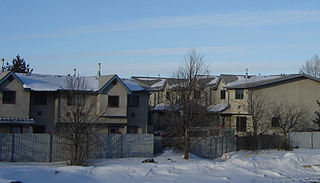
Kensington is a neighbourhood located in west Saskatoon, Saskatchewan, Canada that began construction in 2013. Around 2028, Kensington will reach completion and have an estimated population of 8,300. Kensington will feature Saskatoon's first application of the fused grid street network.
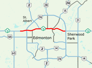
Yellowhead Trail is a 24.6-kilometre (15.3 mi) expressway segment of the Yellowhead Highway in northern Edmonton, Alberta, Canada. It carries a significant amount of truck traffic to and from the industrial areas of north Edmonton and serves as a key commuter route for the bedroom communities of Stony Plain, Spruce Grove, and Sherwood Park, carrying nearly 80,000 vehicles per weekday in 2015. A suburban bypass of the route was completed when the northeast leg of Anthony Henday Drive (Highway 216) opened in late 2016, providing an alternate route through north Edmonton.
Calgary Trail and Gateway Boulevard are a pair of major arterial roadways in Edmonton, Alberta. Gateway Boulevard carries northbound traffic while Calgary Trail carries southbound traffic. From south of 31 Avenue, they form a two-way freeway separated by a median; for this portion, the roadway maintains the separate names for northbound and southbound traffic. Near 31 Avenue, Calgary Trail and Gateway Boulevard separate and become parallel one-way arterial roadways to Saskatchewan Drive, at the edge of the North Saskatchewan River valley. Designated as part of Highway 2 south of Whitemud Drive, it is Edmonton's main southern entrance and is both a major commuter route, connecting to the Edmonton International Airport and Leduc, as well as a regional connection to Red Deer and Calgary.
The Saskatoon Freeway is a proposed four-lane limited access highway in and adjacent to Saskatoon, Saskatchewan. The 55-kilometre (34 mi) route will connect Highway 11 (south) with Highway 7, forming a partial ring road around the city of Saskatoon. When complete, it will serve as a replacement bypass route for the existing Circle Drive.
Marine Drive is the name for three major roadways in Greater Vancouver, British Columbia, Canada. The roads are known for running parallel to major bodies of water, with some sections being a major arterial road, while other serve local traffic. Marine Way is the name applied to a section of Marine Drive that was bypassed in the early 1980s.