Related Research Articles

Geomatics is defined in the ISO/TC 211 series of standards as the "discipline concerned with the collection, distribution, storage, analysis, processing, presentation of geographic data or geographic information". Under another definition, it consists of products, services and tools involved in the collection, integration and management of geographic (geospatial) data. It is also known as geomatic(s) engineering. Surveying engineering was the widely used name for geomatic(s) engineering in the past.
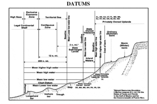
A chart datum is the water level surface serving as origin of depths displayed on a nautical chart. A chart datum is generally derived from some tidal phase, in which case it is also known as a tidal datum. Common chart datums are lowest astronomical tide (LAT) and mean lower low water (MLLW). In non-tidal areas, e.g. the Baltic Sea, mean sea level (MSL) is used. A chart datum is a type of vertical datum and must not be confused with the horizontal datum for the chart.
Geoscience Australia is an agency of the Australian Government. It carries out geoscientific research. The agency is the government's technical adviser on all aspects of geoscience, and custodian of the geographic and geological data and knowledge of the nation.
The Surveyor-General of New South Wales is the primary government authority responsible for land and mining surveying in New South Wales.
Victor John Perton is a former parliamentarian in the Australian state of Victoria, and formerly the Victorian Government's Commissioner to the Americas, based in San Francisco, USA.
Geospatial metadata is a type of metadata applicable to geographic data and information. Such objects may be stored in a geographic information system (GIS) or may simply be documents, data-sets, images or other objects, services, or related items that exist in some other native environment but whose features may be appropriate to describe in a (geographic) metadata catalog.

Anthony Bernard Kelly is an Australian former politician, who was a member of the New South Wales Legislative Council representing the Australian Labor Party from 1997 until 2011.
The United Nations Spatial Data Infrastructure (UNSDI) is an institutional and technical mechanism for establishing system coherence for the exchange and applications of geospatial data and information for UN activities and supporting SDI development activities in Member Countries.
OMB Circular A-16, revised August 19, 2002, is a Government circular that was created by the United States Office of Management and Budget (OMB) to provide guidance for federal agencies that create, maintain or use spatial data directly or indirectly through the establishment of the National Spatial Data Infrastructure (NSDI) and the Federal Geographic Data Committee (FGDC).
The National Biological Information Infrastructure (NBII) was a program coordinated by the United States Geological Survey's Biological Informatics Office within the USGS Biological Resources Discipline. Its purpose was to facilitate access to data and information on the biological resources of the United States, utilizing government agencies, academic institutions, non-government organizations, and private industry. It was terminated 15 January 2012.
The Permanent Committee on Place Names (PCPN) created from the various Australian and New Zealand committees on geographical names. The PCPN started in 1984 as the Committee for Geographical Names in Australia (CGNA) and it was renamed in 2005. It was integrated within the Intergovernmental Committee on Surveying and Mapping (ICSM) in 1993. It is also associated with the Geospatial and Earth Monitoring Division of Geoscience Australia. It contributes to the United Nations Group of Experts on Geographical Names.
Geographic Information Systems (GIS) are an increasingly important component of business, healthcare, security, government, trade, media, transportation and tourism industries and operations in China. GIS software is playing an increasing role in the way Chinese companies analyze and manage business operations.
Sherryl Maree Garbutt is a former Australian politician. Garbutt was awarded the Medal in the Order of Australia in the 2020 Australia Day Honours.
The Western Australian Land Information System (WALIS) was established by the Western Australian (WA) Government in 1981. It is responsible for co-ordinating the discovery of, and access to, location-based or geographic data generated by WA Government agencies. WALIS achieves this through partnerships between organisations, projects, committees and working groups; coordinated through the WALIS Office at Landgate.
The Surveying and Spatial Sciences Institute (SSSI) is the professional association for surveyors and spatial science workers, including cartography, hydrography, remote sensing, engineering and mining surveying, photogrammetry and spatial information in Australia. The Institute's members are involved in communities of practice such as land administration, land development, natural resource management, forestry, agriculture, defence, marine environment, local government, health, education, transport, tourism, and many more. The institute deals with policy, administration, collection, measurement, analysis, interpretation, portrayal and dissemination of spatially- related land and sea information, together with associated planning, design and management.
Andrew Leigh Clarke is a former senior Australian public servant who served as Secretary of several departments and as Chief of Staff to Prime Minister Malcolm Turnbull, before his retirement in April 2017. Since his retirement from the public service he has been appointed to the board of nbn™ and is to become chairman of the Australian Energy Market Operator (AEMO).
Surveying in Australia is triangulation-based and shares many similarities with the United Kingdom, including the title deed system. However, a distinctive feature of surveying in Australia is the Torrens System, where real estate records are held in a central deposit and guaranteed by the state.
Chloe Munro was an Australian energy expert.
Elizabeth O’Keeffe is a former senior public servant in the State Government of Victoria. She was Executive Director of Land Victoria from the early 1990s until 2002 and then the Chief Operating Officer of the National Gallery of Victoria until 2005. After leaving the public service she was a Director of Transparency International Australia until 2013.
Warwick Arthur Watkins (1950–2019) was a senior New South Wales public servant and former member the Australia national rugby union team, the Wallabies.
References
- ↑ "Reference at www.anzlic.gov.au".
- ↑ Masser, I. (2003). Governments And Geographic Information. Taylor & Francis. p. 64. ISBN 978-0-203-21287-5 . Retrieved 2021-01-04.
- ↑ Williamson, Ian P.; Rajabifard, Abbas; Feeney, Mary-Ellen F., eds. (2003-07-10). "Development of the Australian Spatial Data Infrastructure". Developing Spatial Data Infrastructures. CRC Press. doi:10.1201/9780203485774. ISBN 978-0-429-20492-0.
- ↑ Masser, Ian (2011). "Emerging Frameworks in the Information Age: The Spatial Data Infrastructure (SDI) Phenomenon". The SAGE Handbook of GIS and Society. London: SAGE Publications, Inc. pp. 270–286. doi:10.4135/9781446201046.n14. ISBN 978-1-4462-9581-6.
- ↑ "Spatial data infrastructure for Australia and New Zealand".
- ↑ "ANZLIC Strategic Plan 2020-2024" (PDF).
- ↑ Macauley, Craig (2005). "Australia and New Zealand ANZLIC Metadata Guidelines". World Spatial Metadata Standards. Elsevier. pp. 201–218. doi:10.1016/b978-008043949-5/50014-0. ISBN 978-0-08-043949-5.
- ↑ "ANZLIC Council".
- ↑ "Reference at www.anzlic.gov.au".
- ↑ "Michael Bradford, CEO Landgate elected ANZLIC Chair | ANZLIC". www.anzlic.gov.au.
- ↑ "Senior public servant sacked over Currawong".
- ↑ "Senior public servant sacked over Currawong | The Examiner | Launceston, TAS".
- ↑ "Senior public servant sacked over Currawong | The Courier | Ballarat, VIC".
- ↑ "ICAC launches attack on fat cats | PerthNow".
- ↑ "ParlInfo - Entsch welcomes spatial industry initiative". parlinfo.aph.gov.au. Retrieved 2020-03-22.
- ↑ "Reference at www.crcsi.com.au" (PDF).
- ↑ Estate Agents Fund Bureaucrat linked to alleged fraud bid resigns, The Age, 12 July 2020
- ↑ Elizabeth O’Keeffe, DNRE email-memo, "Article in the Age", 12 July 2002
- ↑ "About". Intergovernmental Committee on Surveying and Mapping. Retrieved 2021-01-04.
- ↑ "About | Intergovernmental Committee on Surveying and Mapping".