Related Research Articles
The Defense Advanced Research Projects Agency (DARPA) is a research and development agency of the United States Department of Defense responsible for the development of emerging technologies for use by the military.

Surveillance is the monitoring of behavior, many activities, or information for the purpose of information gathering, influencing, managing or directing. This can include observation from a distance by means of electronic equipment, such as closed-circuit television (CCTV), or interception of electronically transmitted information like Internet traffic. It can also include simple technical methods, such as human intelligence gathering and postal interception.
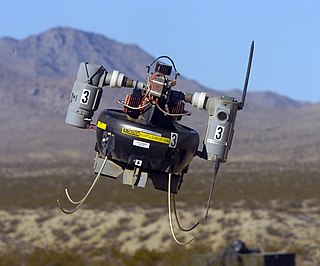
A micro air vehicle (MAV), or micro aerial vehicle, is a class of miniature UAVs that has a size restriction and may be autonomous. Modern craft can be as small as 5 centimeters. Development is driven by commercial, research, government, and military purposes; with insect-sized aircraft reportedly expected in the future. The small craft allows remote observation of hazardous environments inaccessible to ground vehicles. MAVs have been built for hobby purposes, such as aerial robotics contests and aerial photography.

An unmanned ground vehicle (UGV) is a vehicle that operates while in contact with the ground and without an onboard human presence. UGVs can be used for many applications where it may be inconvenient, dangerous, or impossible to have a human operator present. Generally, the vehicle will have a set of sensors to observe the environment, and will either autonomously make decisions about its behavior or pass the information to a human operator at a different location who will control the vehicle through teleoperation.

A miniature UAV, small UAV (SUAV), or drone is an unmanned aerial vehicle small enough to be man-portable. Smallest UAVs are called micro air vehicle.
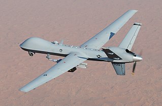
The General Atomics MQ-9 Reaper is an unmanned aerial vehicle (UAV) capable of remotely controlled or autonomous flight operations developed by General Atomics Aeronautical Systems (GA-ASI) primarily for the United States Air Force (USAF). The MQ-9 and other UAVs are referred to as Remotely Piloted Vehicles/Aircraft (RPV/RPA) by the USAF to indicate their human ground controllers.
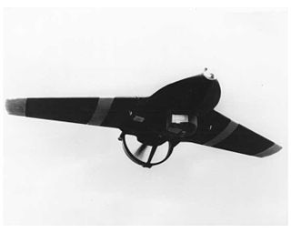
The Lockheed MQM-105 Aquila (Eagle) was the first small battlefield drone developed in the United States during the 1970s to act as a target designator for the US Army.
The Honeywell RQ-16A T-Hawk is a ducted fan VTOL miniature UAV. Developed by Honeywell, it is suitable for backpack deployment and single-person operation.
The DARPA FORESTER is a technology development program sponsored jointly by the Defense Advanced Research Projects Agency (DARPA) and the U.S. Army intended to produce an advanced airborne UHF radar system that can track personnel and vehicles on the ground when they are hidden by foliage. FORESTER is an acronym for FOPEN Reconnaissance, Surveillance, Tracking and Engagement Radar.

The Heterogeneous Aerial Reconnaissance Team (HART)—formerly known as the "Heterogeneous Urban RSTA Team (HURT)"—program was an aerial surveillance project funded by the Information Processing Technology Office of the Defense Advanced Research Projects Agency with program managers John Bay and Michael Pagels. The purpose of the program was to develop systems that could provide continuous, real-time, three-dimensional surveillance of large urbanized areas, using unmanned aerial vehicles. The project team was led by Northrop Grumman Corporation, and involved several other academic and corporate researchers.

The AeroVironment Wasp III Small Unmanned Aircraft System is a miniature UAV developed for United States Air Force special operations to provide a small, light-weight vehicle to provide beyond-line-of-sight situation awareness. The aircraft is equipped with two on-board cameras to provide real-time intelligence to its operators. It is also equipped with GPS and an Inertial Navigation System enabling it to operate autonomously from takeoff to recovery. It was designed by AeroVironment Inc., and was first added to the Air Force inventory in 2007. There are two Wasp variants: the traditional version that lands on land, and a version that lands into the sea or fresh water. The Air Force accepted the Wasp AE in late May 2012, and the U.S. Marine Corps revealed in January 2013 that they had ordered the Wasp AE. The Wasp AE is designated as the RQ-12A.
Gorgon Stare is a video capture technology developed by the United States military. It is a spherical array of nine cameras attached to an aerial drone. The US Air Force calls it "wide-area surveillance sensor system".
The Blue Devil blimp was a proposed reconnaissance airship that was built for the United States Air Force for use in the War in Afghanistan. It was designed to capture and process data from onboard sensors before delivering it to ground troops.
Kestrel is a wide-area motion imagery system used on aerostats at U.S. forward operating bases in Afghanistan to monitor the surrounding areas. Developed by Logos Technologies, the system is equipped with electro-optical and infrared cameras, providing day/night force protection and overwatch to troops.
Constant Hawk is a United States Army wide-area motion imagery system flown on manned reconnaissance aircraft in Iraq and Afghanistan.

The DRDO Netra is an Indian, light-weight, autonomous UAV for surveillance and reconnaissance operations. It has been jointly developed by the Research and Development Establishment (R&DE), and IdeaForge, a Mumbai-based private firm.
The practice of mass surveillance in the United States dates back to wartime monitoring and censorship of international communications from, to, or which passed through the United States. After the First and Second World Wars, mass surveillance continued throughout the Cold War period, via programs such as the Black Chamber and Project SHAMROCK. The formation and growth of federal law-enforcement and intelligence agencies such as the FBI, CIA, and NSA institutionalized surveillance used to also silence political dissent, as evidenced by COINTELPRO projects which targeted various organizations and individuals. During the Civil Rights Movement era, many individuals put under surveillance orders were first labelled as integrationists, then deemed subversive, and sometimes suspected to be supportive of the communist model of the United States' rival at the time, the Soviet Union. Other targeted individuals and groups included Native American activists, African American and Chicano liberation movement activists, and anti-war protesters.
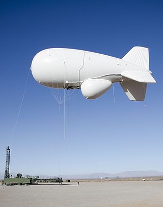
The Joint Land Attack Cruise Missile Defense Elevated Netted Sensor System, or JLENS, was a tethered aerial detection system designed to track boats, ground vehicles, cruise missiles, manned and unmanned aircraft, and other threats. The system had four primary components: two tethered aerostats which utilized a helium/air mix, armored mooring stations, sophisticated radars, and a processing station designed to communicate with anti-missile and other ground and airborne systems. Each system was referred to as an "orbit", and two orbits were built. The Army-led joint program which fielded JLENS was designed to complement fixed-wing surveillance aircraft, saving money on crew, fuel, maintenance and other costs, and give military commanders advance warning to make decisions and provide notifications. Following cost overruns, underperformance, declining support in Congress, and public scrutiny following a snapped tether which allowed one craft moored at Aberdeen Proving Ground, Maryland to drift on a 100-mile uncontrolled descent across Pennsylvania, dragging its cable tether which damaged power lines and cut power to 20,000 homes, the program was suspended in October 2015, and completely discontinued by 2017.
Wide-area motion imagery (WAMI) is an approach to surveillance, reconnaissance, and intelligence-gathering that employs specialized software and a powerful camera system—usually airborne, and for extended periods of time—to detect and track hundreds of people and vehicles moving out in the open, over a city-sized area, kilometers in diameter. For this reason, WAMI is sometimes referred to as wide-area persistent surveillance (WAPS) or wide-area airborne surveillance (WAAS).
References
- ↑ "Drone 'Nightmare Scenario' Now Has A Name: ARGUS". 20 February 2013.
- ↑ "DARPA-BAA-09-55: Persistent Stare Exploitation and Analysis System (PerSEAS)". fbo.gov. 18 September 2009. Archived from the original on 27 June 2019. Retrieved 3 March 2023.
- ↑ "Using 3D Scene Structure to Improve Tracking". 21 February 2012. Archived from the original on 15 December 2021 – via YouTube.
- ↑ "Disclaimer" (PDF).
- ↑ "Persistics Data Processing". Archived from the original on 23 July 2014. Retrieved 16 November 2013.
- ↑ "Persistent Surveillance Systems". Archived from the original on 16 November 2013. Retrieved 16 November 2013.
- ↑ "Home | Pss Preview". pss-1.com.
- ↑ "Archived copy" (PDF). Archived from the original (PDF) on 28 March 2014. Retrieved 16 November 2013.
{{cite web}}: CS1 maint: archived copy as title (link) - ↑ "Pixia and PV Labs Join Forces on Commercially Operated Persistent Surveillance Solution". 5 November 2011. Archived from the original on 11 June 2014.
{{cite journal}}: Cite journal requires|journal=(help) - ↑ "Hiper Stare - PIXIA". pixia.com.
- ↑ "Report Details Government's Ability to Analyze Massive Aerial Surveillance Video Streams". 5 April 2013.
- ↑ "Teame Zazzu - Facebook". Facebook .[ user-generated source ]
- ↑ "1.8 gigapixel ARGUS-IS. World's highest resolution video surveillance platform by DARPA". 27 January 2013. Archived from the original on 15 December 2021 – via YouTube.
- ↑ Bezier, Doug (12 November 2007). "BAE to Develop Surveillance System". The Washington Post . Retrieved 19 February 2010.
- ↑ "BAE has success with ARGUS-IS". UPI. 9 February 2010. Archived from the original on 11 February 2010. Retrieved 19 February 2010.
- ↑ "ARGUS - DARPA's All-Seeing Eye" . Retrieved 1 December 2011.
- ↑ Sierra Nevada fields ARGUS-IS upgrade to Gorgon Stare pod - Flightglobal.com, 2 July 2014
- ↑ "Overview: Autonomous Real-time Ground Ubiquitous Surveillance - Imaging System (ARGUS-IS)". DARPA. Archived from the original on 15 June 2010. Retrieved 19 February 2010.
- ↑ "S&TR April-May 2011 From Video to Knowledge". LLNL. Archived from the original on 11 May 2012. Retrieved 8 May 2012.
- ↑ Smith, Ms. (29 January 2013). "DARPA's unblinking, all-seeing 1.8-gigapixel camera stare on PBS Rise of the Drones". CSO Online.