History
Archeologists have found proof of settlement as early as 4500 BC. The site was a small Roman vicus , flourishing in the second and third centuries AD, where the foundations have been uncovered of a small Celto-Roman temple. After the Second World War restorations to damaged buildings uncovered fragments of Roman rooftiles, of which some bear the markings of a Roman military post, as well as black vases and Roman sandals. The most significant find, however, was that of a Roman building with a foundation of 18 by 10 meters. The Roman Castellum was in use from 175 to 270 AD. [3]
On top of the foundations of this Roman building there were the remains of a Medieval building, which was destroyed in 1383 according to later accounts. Rodenburgh was granted city rights in 1127 and is thus one of the oldest cities in the Netherlands and is the oldest city in Zealand.
On June 25-26 1672 it was the French tried to take over but the citizens resisted bravely
Until January 1, 1995, Aardenburg was a separate municipality. Until January 1, 2003, it was then in the municipality of Sluis-Aardenburg. In 2003 Sluis-Aardenburg and nearby Oostburg were combined into an enlarged Sluis municipality.
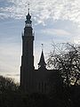
Aardenburg was walled at the end of the thirteenth century: the present Kaaipoort at the old town's western entrance dates only from the sixteenth century. The name of the gate recalls Aardenburg's former harbour, the site of which is now dominated by a bank. The blue banner decorating the Kaaipoort in this picture is a temporary embellishment, celebrating the carnival that precedes Lent.

Ghent is a city and a municipality in the Flemish Region of Belgium. It is the capital and largest city of the East Flanders province, and the third largest in the country, after Brussels and Antwerp. It is a port and university city.
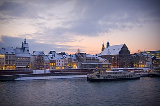
Maastricht is a city and a municipality in the southeastern Netherlands. It is the capital and largest city of the province of Limburg. Maastricht is located on both sides of the Meuse, at the point where the Jeker joins it. Mount Saint Peter (Sint-Pietersberg) is largely situated within the city's municipal borders. Maastricht is adjacent to the border with Belgium and is part of the Meuse-Rhine Euroregion, an international metropolis with a population of about 3.9 million, which includes the nearby German and Belgian cities of Aachen, Liège, and Hasselt.

Haarlem is a city and municipality in the Netherlands. It is the capital of the province of North Holland. Haarlem is situated at the northern edge of the Randstad, one of the more populated metropolitan areas in Europe; it is also part of the Amsterdam metropolitan area. Haarlem had a population of 162,543 in 2021.

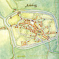
Oostburg is a city in the south-western Netherlands. It is located in the municipality of Sluis, in the province of Zeeland. As of 1 January 2015, its population is 4731, down from 5008 in January 2005. It received city rights in 1237. Before 1 January 2003, Oostburg was also the name of a municipality. It merged with Sluis-Aardenburg to form the new municipality of Sluis. The municipality covered an area of 224.93 km², of which 1.05 km² was water. As well as the town of Oostburg, the former municipality also included the following towns, villages and townships:

Sluis-Aardenburg was a municipality in the province of Zeeland, in the south-western part of the Netherlands. It was created from a merger of Sluis and Aardenburg in 1995, and it merged with the municipality of Oostburg, on 1 January 2003, to form the new municipality of Sluis. Sluis-Aardenburg covered an area of 83.48 km², of which 0.89 km² was water.

Valkenburg aan de Geul is a municipality situated in the southeastern Dutch province of Limburg. The name refers to the central town in the municipality, Valkenburg, and the small river Geul passing through it.

Dilbeek is a municipality in the province of Flemish Brabant, in the Flemish region of Belgium. The municipality comprises the villages of Dilbeek proper, Groot-Bijgaarden, Itterbeek, Schepdaal, Sint-Martens-Bodegem, and Sint-Ulriks-Kapelle. Dilbeek is located just outside the Brussels-Capital Region, in the Pajottenland, hence the local name Poort van het Pajottenland. Even though Dilbeek is located in the Dutch language area of Belgium, there is a French-speaking minority represented by 3 members on the 35-seat local council. It is a mostly residential community with some preserved rural areas and some industrial zones.

Sluis is a town and municipality located in the west of Zeelandic Flanders, in the south-western Dutch province of Zeeland.

Maaseik is a city and municipality in the Belgian province of Limburg. Both in size and in population, it is the 8th largest municipality in Limburg. The town is the seat of the administrative arrondissement of Maaseik (kieskanton). Internationally, Maaseik is known as the assumed birthplace of the famous Flemish painters Jan and Hubert van Eyck.

Lindos is an archaeological site, a fishing village and a former municipality on the island of Rhodes, in the Dodecanese, Greece. Since the 2011 local government reform it is part of the municipality Rhodes, of which it is a municipal unit. The municipal unit has an area of 178.9 km2. It lies on the east coast of the island. It is about 40 km south of the city of Rhodes and its fine beaches make it a popular tourist and holiday destination. Lindos is situated in a large bay and faces the fishing village and small resort of Charaki.

Sint Anna ter Muiden is a small city in the province of Zeeland, Netherlands. It is administratively a part of municipality of Sluis, and the town of Sluis lies about 1 km east. It is located on the westernmost point of the Netherlands. It has a population of 50.
Portmahomack is a small fishing village in Easter Ross, Scotland. It is situated in the Tarbat Peninsula in the parish of Tarbat. Tarbat Ness Lighthouse is about three miles from the village at the end of the Tarbat Peninsula. Ballone Castle lies about one mile from the village.

Zaamslag is a village in the Dutch province of Zeeland. It is a part of the municipality of Terneuzen, and lies about 28 km southeast of Vlissingen.

Sint Kruis is a village in the Dutch province of Zeeland. It is located about 4 km east of Aardenburg, in the municipality of Sluis.
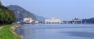
Mount Saint Peter, also referred to as Caestert Plateau, is the northern part of a plateau running north to south between the valleys of the river Geer to the west, and the Meuse to the east. The plateau runs from Maastricht in the Netherlands, through Riemst in Belgian Limburg almost to the city of Liège in Belgium, thus defining the topography of this border area between Flanders, Wallonia and the Netherlands. The name of the hill, as well as the nearby village and church of Sint Pieter and the fortress of Sint Pieter, refers to Saint Peter, one of the Twelve Apostles.

Saint Bavo of Ghent is a Roman Catholic and Eastern Orthodox saint. He was the son of Pepin of Landen and the brother of saints Begga and Gertrude of Nivelles.
Ename is a Belgian village in the Flemish province of East Flanders. It stands on the right side of the river Scheldt and it is part of the municipality of Oudenaarde. The territory was inhabited during Prehistoric and Roman times, and became a trade settlement during the 10th century. From the 11th century it was part of the domain of the Benedictine abbey of Saint Salvator, until its 1795 dissolution in the aftermath of the French Revolution. The remains of the Saint Salvator abbey are today part of a major heritage project in Flanders, established by the Province of East-Flanders. The Provincial Archaeological Museum of Ename displays the major finds that have been excavated on the abbey site. Today the village of Ename hosts the Museumnacht in July and the Feeste t' Ename with the traditional horse market that has been held for centuries during the celebrations of the patron hallow Saint Laurentius, on the 10th of August.

Saint Bavo's Abbey is a former abbey in the currently Belgian city of Ghent. It was founded in the 7th century by Saint Amand, who also founded Saint Peter's Abbey, Ghent, near the confluence of the Leie and Scheldt rivers. Originally, the abbey was also called Ganda, a name of Celtic origin, meaning "river mouth", referring to the Leie river debouching into the Scheldt river.

The Saint Bavo Church is a Dutch Reformed church building in Aardenburg, Netherlands.

Burg Square is a square and former fortress in Bruges. It is one of the main squares of the city.