
East Falmouth is a census-designated place (CDP) in the town of Falmouth in Barnstable County, Massachusetts, United States. It is located at the base of Massachusetts' "fishhook" peninsula. The population was 6,038 at the 2010 census, making East Falmouth the most populous of the six CDPs in Falmouth.

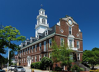
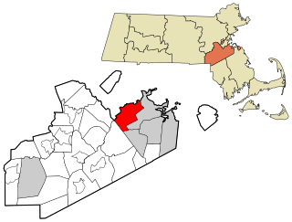
Quincy is a U.S. city in Norfolk County, Massachusetts. It is the largest city in the county and a part of Metropolitan Boston as one of Boston's immediate southern suburbs. Its population in 2010 was 92,271, making it the eighth-largest city in the state. Known as the "City of Presidents", Quincy is the birthplace of two U.S. presidents—John Adams and his son John Quincy Adams—as well as John Hancock, a President of the Continental Congress and the first signer of the Declaration of Independence, as well as being the first and third Governor of Massachusetts.

Swampscott is a town in Essex County, Massachusetts, United States, located 15 miles (24 km) up the coast from Boston in an area known as the North Shore. The population was 13,787 as of 2010. A former summer resort on Massachusetts Bay, Swampscott is today a fairly affluent residential community and includes the village of Beach Bluff, as well as part of the neighborhood of Clifton.

Holbrook is a town in Norfolk County, Massachusetts, United States. As of 2010, the town's population was 10,791.

The town of Randolph is a suburban city in Norfolk County, Massachusetts, United States. At the 2010 census, the city population was 32,158. Randolph adopted a new charter effective January 2010 providing for a council-manager form of government instead of the traditional town meeting. Randolph is one of thirteen Massachusetts municipalities that have applied for, and been granted, city forms of government but wish to retain "The town of" in their official names.
Weymouth is a city in Norfolk County, Massachusetts, and one of 13 municipalities in the state to have city forms of government while retaining "town of" in their official names. It is named after Weymouth, Dorset, a coastal town in England, and is the second-oldest settlement in Massachusetts, second only to Plymouth. It is one of the South Shore's more affordable towns and offers a short commute into Boston, MBTA bus and rail service, and a town beach.
Milton is a town in Norfolk County, Massachusetts, United States, and an affluent suburb of Boston. The population was 27,003 at the 2010 census. Milton is the birthplace of former U.S. President George H. W. Bush and architect Buckminster Fuller. In 2007, 2009, and 2011, Money magazine listed Milton as 7th, 5th, and 2nd, respectively, on its annual list of the "Best Places to Live" in the United States.

Quincy Adams station is a rapid transit station in Quincy, Massachusetts. It serves the Braintree Branch of the MBTA's Red Line. Located in southern Quincy on Burgin Parkway near the Braintree Split, the station features a large park and ride garage, with space for 2,538 automobiles, built over the station tracks and platforms. It is fully accessible.

Quincy Center station is an intermodal transit station in Quincy, Massachusetts. It is a transfer station between the MBTA Red Line subway, MBTA Commuter Rail's Old Colony Lines and Greenbush Line, and a number of MBTA bus routes. It is located between Hancock Street and Burgin Parkway in the Quincy Center district. Opened in 1971, the station was covered by a large parking garage which was closed in 2012 due to structural problems. A project to remove and replace the garage is under way.

Houghs Neck is a one-square-mile (2.6 km2) peninsula in Quincy, Massachusetts. It is surrounded by Quincy Bay, Hingham Bay and Rock Island Cove. It is lined by Perry Beach, which runs along Manet Avenue; Nut Island, which is just beyond Great Hill at the very end of the peninsula; and Edgewater Drive.

Quincy Point is a neighborhood of Quincy, Massachusetts. "The Point" is generally defined as the land east of Quincy Center, the downtown district. Quincy Point is bordered on the west by Elm Street, on the east by Weymouth Fore River and the Braintree city line, on the north by Town River and on the south by Quincy Avenue. The area altitude averages about 30 feet (9.1 m) above sea level. The population of this neighborhood in 2000 was 11,414.
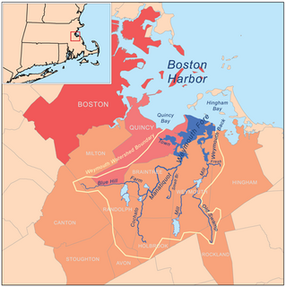
Weymouth Fore River is a small bay or estuary in eastern Massachusetts and is part of the Massachusetts Bay watershed.

Germantown is a primarily residential neighborhood in the city of Quincy, Massachusetts. The neighborhood is located on a peninsula surrounded by Town River Bay on the west and Rock Island Cove on the east. This peninsula was known since the 1640s as “Shed's Neck”.

Merrymount is a primarily residential neighborhood of Quincy, Massachusetts, USA, located between the neighborhoods of Quincy Center and Adams Shore. Although it was the site of Quincy's initial settlement, Merrymount was not substantially developed for residential use until the first half of the 20th century, and most of the neighborhood's houses date from that period.

Quincy Bay is the largest of the three small bays of southern Boston Harbor, part of Massachusetts Bay and forming much of the shoreline of the city of Quincy, Massachusetts. Locally in the Wollaston neighborhood of Quincy it is known as Wollaston Bay. The bay is home to Moon Island, Long Island, and Hangman Island.

Furnace Brook Parkway is a historic parkway in Quincy, Massachusetts. Part of the Metropolitan Park System of Greater Boston, it serves as a connector between the Blue Hills Reservation and Quincy Shore Reservation at Quincy Bay. First conceived in the late nineteenth century, the state parkway is owned and maintained by the Massachusetts Department of Conservation and Recreation (DCR) and travels through land formerly owned by the families of John Adams and John Quincy Adams, passing several historic sites. It ends in the Merrymount neighborhood, where Quincy was first settled by Europeans in 1625 by Captain Richard Wollaston. The road was started in 1904, completed in 1916 and added to the National Register of Historic Places (NRHP) in 2004.
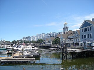
Marina Bay is a mixed-use development neighborhood of condominium, commercial and entertainment facilities in Quincy, Massachusetts. It includes five housing complexes and one assisted living complex, office complexes, numerous restaurants, a 685-slip marina and a seaside boardwalk. It is situated on the northwestern part of Squantum Peninsula at the mouth of the Neponset River where it meets Dorchester Bay in Boston Harbor. The permanent residential population of Marina Bay in 2000 was about 1,300 according to the United States Census Bureau,; however, the Boston Globe reported in 2004 that the complex had 2,000 residents.
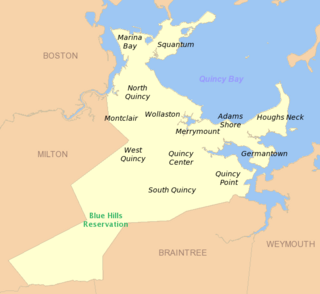
South Quincy is a neighborhood of Quincy, Massachusetts. Located in the south central portion of the city, South Quincy is bordered on the north by Quincy Center and West Quincy, on the east by Quincy Avenue and the Quincy Point neighborhood, on the south by Braintree and on the west by Interstate 93.

Squantum is a neighborhood of Quincy, Massachusetts, connected to the mainland by a causeway that crosses over a wetland area of the bay. Often thought of as a peninsula, Squantum proper is technically a barrier island as it is surrounded on all four sides by water and is only connected to the mainland and Moon Island via causeways. Located in the northernmost portion of the city, Squantum is bordered on the north by Dorchester Bay and Boston Harbor, on the east by Moon Island and Quincy Bay, on the south by Quincy Bay and North Quincy, and on the west by the Marina Bay development. The population of the neighborhood in 2000 according to the United States Census Bureau was 2,626. Squantum has scenic, waterfront views of Boston Harbor and the Boston skyline and has many of Quincy’s most expensive homes. Squantum residents are the wealthiest of any neighborhood in Quincy, according to the 2010 United States Census Bureau, and the home ownership rate is approximately 92%. The neighborhood is further characterized by its tree-lined streets, its "island getaway" feel, close-knit community, and its annual Squantum Fourth of July Parade. As described in a 2020 book, "One road leads in and out of a square mile of land that is a playground for children and a haven for adults." Squantum also has one of the largest Irish populations, on a per capita basis, of any neighborhood in the United States
West Quincy is a neighborhood of Quincy, Massachusetts. It is bordered on the north by Wollaston, on the east by Quincy Center, on the south by South Quincy and on the west by the town of Milton and the Blue Hills Reservation.

