
Newfoundland and Labrador is the easternmost province of Canada, in the country's Atlantic region. The province comprises the island of Newfoundland and the continental region of Labrador, having a total size of 405,212 square kilometres. In 2023, the population of Newfoundland and Labrador was estimated to be 533,710. The island of Newfoundland is home to around 94 per cent of the province's population, with more than half residing in the Avalon Peninsula. Labrador borders the province of Quebec, and the French overseas collectivity of Saint Pierre and Miquelon lies about 20 km (12 mi) west of the Burin Peninsula.

Labrador is a geographic and cultural region within the Canadian province of Newfoundland and Labrador. It is the primarily continental portion of the province and constitutes 71% of the province's area but is home to only 6% of its population. It is separated from the island of Newfoundland by the Strait of Belle Isle. It is the largest and northernmost geographical region in the four Atlantic provinces.

Nain is the northernmost permanent settlement in the Canadian province of Newfoundland and Labrador, within the Nunatsiavut region, located about 370 km (230 mi) by air from Happy Valley-Goose Bay. The town was established as a Moravian mission in 1771 by Jens Haven and other missionaries. As of 2021, the population is 1,204 mostly Inuit and mixed Inuit-European. Nain is the administrative capital of the autonomous region of Nunatsiavut.
The 1929 Grand Banks earthquake occurred on November 18, 1929. The shock had a moment magnitude of 7.2 and a maximum Rossi–Forel intensity of VI and was centered in the Atlantic Ocean off the south coast of Newfoundland in the Laurentian Slope Seismic Zone.
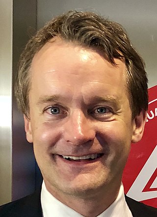
Seamus Thomas Harris O'Regan is a Canadian politician who has been the federal minister of labour since October 26, 2021 and minister of seniors since July 26, 2023. A member of the Liberal Party, O'Regan was elected to the House of Commons in 2015, representing St. John's South—Mount Pearl. He has been in Cabinet since 2017, previously serving as minister of natural resources from 2019 to 2021, minister of Indigenous services in 2019, and minister of veterans affairs and associate minister of national defence from 2017 to 2019. Before he entered politics, O'Regan was a correspondent with CTV National News, and a host of Canada AM, which he co-hosted from 2003 to 2011 with Beverly Thomson.
St. George's Bay - informally referred to as Bay St. George due to its French translation Baie St-George - is a large bay in the province of Newfoundland and Labrador, Canada. It is located on the west coast of the island of Newfoundland and comprises a sub-basin of the Gulf of St. Lawrence.
Ramea is a small village in Newfoundland and Labrador located on Northwest Island, one of a group of five major islands located off the south coast of Newfoundland, Canada. The island is approximately 3.14 km long by 0.93 km wide. The other major islands in the archipelago are Great Island, Middle Island, Harbour Island, and South West Island.

Boyd's Cove, also known as Boyd's Harbour, is a local service district and designated place in the Canadian province of Newfoundland and Labrador that is near Lewisporte. There is an interpretive centre dedicated to the earlier indigenous Beothuk settlement at this location.
Baie Verte is a town located on the north coast of the island portion of the Canadian province of Newfoundland and Labrador on the Baie Verte Peninsula.

The history of post-confederation Canada began on July 1, 1867, when the British North American colonies of Canada, New Brunswick, and Nova Scotia were united to form a single Dominion within the British Empire. Upon Confederation, the United Province of Canada was immediately split into the provinces of Ontario and Quebec. The colonies of Prince Edward Island and British Columbia joined shortly after, and Canada acquired the vast expanse of the continent controlled by the Hudson's Bay Company, which was eventually divided into new territories and provinces. Canada evolved into a fully sovereign state by 1982.
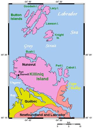
Killiniq Island is a remote island in southeastern Nunavut and northern Newfoundland and Labrador, Canada. Located at the extreme northern tip of Labrador between Ungava Bay and the Labrador Sea, it is notable in that it contains the only land border between Nunavut and Newfoundland and Labrador. Most other islands off the northern coast of Quebec and Labrador belong exclusively to Nunavut. Some cartographic sources do not correctly show the island's geopolitical boundaries; for instance, the Commission de toponymie du Québec seems to show it as belonging to Quebec.

Newfoundland and Labrador is the easternmost province in Canada. The Strait of Belle Isle separates the province into two geographical regions, Labrador and the island of Newfoundland. The province also includes over seven thousand small islands.

Frederickton is a designated place in the Canadian province of Newfoundland and Labrador.
Purcell's Harbour is a local service district and designated place in the Canadian province of Newfoundland and Labrador. It is on the southern Twillingate island, about 4 km (2.5 mi) outside the town of Twillingate, near the community of Little Harbour.

Newfoundland is a large island situated off the eastern coast of the North American mainland and the most populous part of the Canadian province of Newfoundland and Labrador. The island contains 29 percent of the province's land area. The island is separated from the Labrador Peninsula by the Strait of Belle Isle and from Cape Breton Island by the Cabot Strait. It blocks the mouth of the Saint Lawrence River, creating the Gulf of Saint Lawrence, the world's largest estuary. Newfoundland's nearest neighbour is the French overseas collectivity of Saint Pierre and Miquelon.
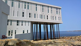
Fogo Island is a town located on Fogo Island, the largest of the offshore islands in the province of Newfoundland and Labrador, Canada.

The border between the province of Quebec and the province of Newfoundland and Labrador is the longest interprovincial border in Canada. It stretches for more than 3,500 kilometres (2,200 mi) on land, and, according to both provincial governments, also contains a maritime part. Starting from the north, the border follows the Laurentian Divide on the Labrador Peninsula for the majority of the border's length, then follows the divide between the Côte-Nord-Gaspé and Newfoundland-Labrador drainage basins as far as Brûlé Lake, then follows the Romaine River downstream to the 52nd parallel, which it follows east to its southeastern terminus at Blanc-Sablon.
Main Point-Davidsville is a local service district and designated place in the Canadian province of Newfoundland and Labrador. It consists of the communities of Main Point and Davidsville.
Random Sound West, previously known as Hillview-Adeytown-Hatchet Cove-St. Jones Within, is a local service district and designated place in the Canadian province of Newfoundland and Labrador.
